


 nova página do texto(beta)
 Inglês (pdf)
 Artigo em XML
 Referências do artigo
 Enviar este artigo por email
 Citado por SciELO
  Similares em
SciELO
Similares em
SciELO 
 Permalink
Mexican conifer and oak forests support high levels of biodiversity (Rzedowski, 1978; Challenger, 1998), concentrate > 95 % of wood production in Mexico (Pérez-Salicrup et al., 2006; Balvanera et al., 2009), and provide important environmental services that benefit human welfare far beyond their geographical limits. There are, however, few studies on the regeneration and patch dynamics of these forests in Mexico, and about the relationships between patch dynamics and tree diversity (Fulé et al., 2000; Gonzalez-Tagle et al., 2008). Conifer and oak forests were largely converted to agriculture since the beginning of Spanish colonization (1521) on the plateaus and montane valleys of central Mexico (Challenger, 2003). Where such forests are still dominant, their structure, composition and area remain affected by natural and human disturbances, particularly cattle grazing, and forest management (Minnich et al., 2000; Mas et al., 2004, Calderon-Aguilera et al., 2012). In this study we analyze patch dynamics in a conifer and oak forest in Aguascalientes State in Central Mexico, and evaluate the implications for these dynamics in terms of tree diversity preservation.
Disturbances in conifer and oak forests in Mexico, and the variable nature of vegetation recovery, have imposed a dynamic mosaic upon the landscape, comprising vegetation patches of different sizes and degrees of vegetation cover (Minnich et al., 2000; Jardel-Peláez et al., 2004). Within the landscape, a patch is defined as a surface that can be differentiated from its surroundings by differences in properties such as plant species composition or percentage of vegetation cover (Pickett and White, 1985; Forman and Godron, 1986). Understanding the transitions, pathways, and dynamics of vegetation cover in these patches is fundamental for the implementation of appropriate management practices in these forests, particularly in areas under conservation.
The Sierra Fria, located in the southern part of the Sierra Madre Occidental in Central Mexico, was declared a Natural Protected Area by the Aguascalientes State Government (Gobierno del Estado de Aguascalientes, 1994). This region apparently was not heavily affected by agricultural conversion or by timber and firewood extraction during the period between the arrival of the Spaniards and the beginning of the 20th century, probably because access from the main population centers of the time was difficult and no major human settlements had been established within these mountains (Minnich et al., 1994). However, this situation changed drastically between 1920 and 1950, when roads were built, connecting these mountains to the city of Aguascalientes, and tree felling in the Sierra Fria forests increased in order to produce posts, charcoal, and timber (Minnich et al., 1994). At least two saw mills were established within the Sierra Fria during that period. Nevertheless, as fossil fuels replaced charcoal for domestic use during the 1950s, and also partly as a consequence of a nation wide ban on timber harvesting in the same decade, timber extraction in the forests of the Sierra Fria was drastically reduced, and the forests began to regenerate. This history of human disturbances, and associated vegetation recovery processes, has produced a heterogeneous mosaic of vegetation patches in the Sierra Fria (Minnich et al., 1994; Chapa-Bezanilla et al., 2008). Today, the vegetation is dominated by white oaks and conifers (see below). Although Sierra Fria is a State protected area, most of the land is still privately owned. Land owners work together with State authorities to plan and implement a management plan.
Several studies have evaluated plant succession in response to changes in land use across different ecosystems. For example, in the temperate forests of the northeastern United States of America (Foster, 1992; Foster et al., 1997) and the tropical forests of Puerto Rico (Marcano-Vega et al., 2002; Grau et al., 2003), human migration from rural to urban areas has allowed plant succession to re-establish forest cover. The rate and degree to which these secondary forests acquire a composition and structure similar to that of old growth forests can vary drastically across ecosystems, and as a consequence of the intensity of land use practiced (Martin et al., 2004; Kleijn et al., 2006).
In Mexico, there have been very few studies documenting and characterizing the recovery of vegetation as a consequence of reduction in the pressure on forest resources, or as a consequence of land use change (Turner II et al., 2001; Klooster, 2003; López et al., 2006; Mendoza et al., 2011). Because this lack of knowledge is particularly dramatic in conifer and oak forests, in this study we combine analyses of temporal changes in the size and cover of vegetation patches, with an assessment of the current canopy vegetation of patches of different vegetation cover classes, to understand forest patch dynamics and its relation to tree and shrub diversity. This information should provide useful to advice on management objectives for the Study area, and will provide new information of conifer and oak forest patch dynamics.
Material and methods
Study site. The present study was conducted in dry conifer-oak forest within the Sierra Fria Natural Protected Area (SF-NPA), decreed in 1994, and located in the northwest of the State of Aguascalientes, Central Mexico, at 21° 31’- 23° 52’ N and 102° 22’- 102° 50’ W (Gobierno del Estado de Aguascalientes, 1994). Elevations in the studied region range between 2,200 and 3,050 m, where the geoforms are dominated by volcanic mesas and their associated ravines, covering around 70,000 ha. Mean annual temperature is 17 ºC, and the region receives 600 mm of rain year-1, concentrated mostly during June - August. Mature forest vegetation is dominated by Pinus leiophylla Schltdl. & Cham. and P. teocote Cham. & Schltdl, Quercus potosina Trel., Q. eduardii Trel., and Q. sideroxyla Bonpl (Siqueiros, 1989). Despite its protected status, low density breeding of domestic cattle, firewood extraction, and hunting are still conducted in the SFPNA. The first two activities are concentrated mostly on sites with slopes < 10 % and close to roads, while the latter is practiced throughout most of the reserve, but with little impact on vegetation, except in a few small (< 0.5 ha) scattered oat plantations established to attract wild turkey.
Selection and interpretation of images. We analyzed aerial photographs and a satellite image to evaluate the changes in number, size and cover of canopy vegetation in patches (sensu Kennedy and Spies, 2004, 2005). We used three different series of aerial photograph from different dates. The first series was taken in March 1956 and had a scale of 1:50,000; the second series was from April 1970, with a scale of 1:37,500; and the third series were 1:20,000 scale orthophotos taken in March 1993. For the year 2003, we used a satellite Spot® image with 10 m of spatial resolution. The 1956 and 1970 aerial photographs were digitized at 600 dpi and georeferenced by the polynomial adjustment method using control points identified in the 1993 orthophoto mosaic (Lillesand, 1982). The digitalization of photographs gave a resolution of 2 m for each of the aerial photographs, which could be adjusted to the resolution of the 2003 Spot satellite image. All images were projected to NAD 27. Processing, georeferencing and geographical correction of aerial photographs were conducted in the Laboratory of Analysis of Agroecosystems and Natural Resources of the Center of Agricultural Sciences of the Autonomous University of Aguascalientes during 2007 (see Chapa-Bezanilla et al., 2008). The resulting photographic mosaics for the years 1956, 1970 and 1993, and the 2003 Spot satellite image were overlaid in order to detect and study the area and cover of all vegetation patches. Patches were defined as components in the landscape that differed in vegetation cover relative to their surrounding vegetation. The minimum mapping area was 6.5 ha.
Number, size and class of canopy vegetation cover. Vegetation patches were identified in each year of analysis (Figure 1). Patches in each of the four dates for which it had images were classified into one of four categories according to their canopy vegetation cover: 1 < 10 %, 2 = 11- 30 %, 3 = 31- 50 %, and 4 > 50 % . Spatial analysis of images was conducted with the program ArcView® Ver. 3.3 (ESRI, 2009) to identify patches and classify their vegetation cover, and the module ArcEdit to measure their patch area.

Figure 1 The figure shown the dynamic in the landscape of Sierra Fria Natural Protected Area. A) The figure shown the changes in area of patches in the period 1956-1993. B) Changes in the coverage in patches of landscape analized
To compare changes in patch size in the study region, we counted the number of patches that maintained, reduced or increased their area during each one of the three study periods, i.e.: 1956 - 1970, 1970 - 1993, and 1993 - 2003, and also reported the number of patches that experienced a significant change in an area for each of the three periods . We used the typology of Oliver and Larson (1996) to characterize changes within a patch area, which includes increases or reductions in the size of the patches, or having gaps of a different type of vegetation within its limits. We compared the averages size of the patches using a one-way analysis of variance.
To analyze the changes in the canopy vegetation cover of patches in the mixed forest, the number of patches that remained within the same vegetation cover class, or that changed to a lower or higher vegetation cover class are reported in a compound Matrix format, which allows the visual inspection of transition changes in each individual time period, and over the whole study period. We evaluated whether the number of patches that changed or remained in the same vegetation cover class was independent of the period of study with a χ 2 independence test (Sokal and Rohlf, 1995). We evaluated which of the three periods of analysis was most dynamic in terms of the number of patches that changed in canopy vegetation cover class over the number of years for each particular period.
Description of vegetation of patches with different canopy cover class. We established one vegetation plot in at least five patches for each cover class during the summer of 2008. Plots were squares of 16 × 16 m, following the recommendations of Daget and Godron (1982), and were established by randomly selecting patches a given vegetation cover class, and then randomly locating each plot within the vegetation patch.
In each plot, we counted, identified and measured the diameter at breast high (DBH; at 1.3 m) of all individual trees ≥ 1.5 m, hereafter considered overstory trees (sensu Fulé and Covington, 1998; Fulé et al., 2000). We also identified and counted trees 0.5 - 1.5 m in height, hereafter considered understory trees (sensu Fulé and Covington, 1998; Fulé et al., 2000). In addition, we counted, identified and measured the diameter of all shrubs > 0.5 m in height. We considered shrubs as those individuals with multiple stems at the base of each trunk and lacking a clear single vertical axis (Mabberley, 1997). In shrubs with multiple stems with a DBH of more tan 5 cm, we measured the diameter in each stem. With the diameter of trees was estimated the basal area (BA). Species were identified in situ according to the keys proposed by De la Cerda (1989) for oaks, and Siquéiros (1989) for conifers. Identities were corroborated in the herbarium of the Autonomous University of Aguascalientes (HBUAA). We estimated the mean density, basal area, tree diameter, and total species richness, and identified the dominant tree species for overstory trees and shrubs in all vegetation cover classes. For the understory trees, we estimated mean density and species richness. For mean density and basal area of overstory trees, we conducted a simple linear regression, using vegetation cover class as the independent variable, in order to determine whether there was a significant tendency to increase. In addition, we estimated the Shannon-Wiener diversity index as an indicator of alpha tree diversity for overstory trees in all plots, and compared it across classes with a one-way ANOVA. Means and standard errors of the mean are reported throughout this manuscript.
Results
Number, Size and Canopy Cover of Patches. The overall number of patches remained almost constant throughout the entire period of study (1956 = 56, 1970 = 57, 1993 = 58, and 2003 = 59). One third of all patches changed their size over the 47 years of analysis. During the first study period (1956-1970), 38 patches maintained their size, two decreased in area, and 15 increased in area; in this period, two new patches appeared different of the first date of analysis (1956), for a total patch area of 12,309.2 ha. During the second period (1970-1993), the number of patches that maintained their size was similar to the first period (n = 36), however, although more patches (n = 8) decreased in size and less patches increased in size (n = 14) compared to the previous period, the total area covered by patches increased by only 321.3 ha. Finally, during the last period (1993-2003) most patches maintained their area (n = 52), only three decreased in area, and five increased. In this final period the total area covered by vegetation patches changed less than the minimum mapping area, so we can consider that no change occurred.
During the period 1956-1970, 1.21 patches changed in area per year, while 0.96 and 0.80 patches per year changed in area during 1970 - 1993 and 1993 - 2003, respectively. The types of changes observed in patch size were either reductions or increases in patch area (sensu Kennedy and Spies, 2004; Hummel and Cunningham, 2006). We did not observe changes in patch area associated with the development of a different patch within a patch, nor patches that increased in size and then decreased, or vice versa. Mean patch size over the four dates of observation was not significantly different, 1956 = 201.8 (Standard error of the mean, SE = 7.88 ha), 1970 = 212.7 (SE = 7.68 ha), 1993 = 220.3 (SE = 7.48 ha), and 2003 = 217.3 (SE= 7.48 ha).
Similar to patch size, vegetation cover class was also very dynamic over the four different years of observation. From the 59 patches present in the final period of analysis, only 17 (28.8 %) remained unchanged from the first year of observation (Table 1). Twelve of these unchanged patches remained within the lowest vegetation cover category. The number of patches that changed in the canopy vegetation cover category was not independent of the period of study analyzed (χ 2 = 14.1, d.f. = 2, P = 0.001). Over the first period, 1956-1970, 39 patches remained in the same canopy vegetation cover class, 18 advanced to a higher cover class, while none regressed to a lower class category. During 1970 - 1993, 22 patches remained in the same canopy vegetation cover class, 31 advanced to a higher class, and 5 regressed to a lower class. During the final period, 1993 - 2003, 21 patches remained in the same canopy vegetation cover class, 33 advanced and 5 regressed in class, respectively (Table 1). The number of patches that changed in vegetation cover per year increased from 1.3 in 1956 - 1970, to 1.6 in 1970 - 1993, and to 1.8 from 1993 - 2003. The number of patches that advanced to a higher vegetation cover class per year remained almost equal at 1.3 patches per year during the first two studied periods, but increased to 3.3 during 1993- 2003.
Table 1 Matrices representing transitions of patches to different vegetation cover class through three different periods of analysis in the Sierra Fria Protected Natural Area, Mexico. Shaded cells in the diagonal represent number of patches that did not change in vegetation cover through the period. In horizontal comparison of matrices (i.e.: 1970 vs. 1993 and 2003) cells above the diagonal represent the number of patches that moved to a higher class of vegetation cover, while cells below the diagonal represent the number of patches that moved to a lower vegetation cover class. In vertical comparison (i.e.: 1956 vs. 1970, 1993 and 2003) cells above the diagonal represent the number of patches that moved to a lower vegetation cover class, and cells below the diagonal represent the number of patches that moved to a higher vegetation cover class.

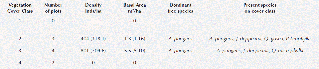
Vegetation in Patches with Different Cover Class. We did not find any overstory trees in vegetation patches of canopy cover class 1 (Table 2). For the other three canopy cover categories, we found a significant increase in tree density (r 2 = 0.16, F = 4.15, P < 0.05), and basal area (r 2 = 0.27, F = 8.12, P < 0.01) as canopy vegetation cover class increased. Species richness and diversity, however, did not differ between the three vegetation cover classes where trees were found (Table 2). In all of these, the dominant species was Juniperus deppeana Steud. The density of understory trees increased significantly in vegetation patches with higher categories of canopy vegetation cover (r 2 = 0.27, F = 9.88, P = 0.04), but the number of species did not differ (Table 3). Interestingly, J. deppeana was the dominant tree species for both over- and understory trees across all canopy vegetation cover classes where trees were found. We did not find any shrubs in canopy cover classes 1 and 4 (Table 4). In the intermediate canopy cover classes (categories 2 and 3), shrub density, basal area, and number of species did not differ. The dominant shrub species was Arctostaphylos pungens Kunth. (Table 4).
Table 2 Overstory tree (trees ≥1.5 m in height) community characteristics in plots representing vegetation patches of different canopy cover class in the Sierra Fria Protected Natural Area, Mexico. Numbers in parenthesis represent 1 standard error of the mean.

Table 3 Understory tree (trees 0.5 - 1.5 m in height) community characteristics in plots representing vegetation patches of different canopy cover class in the Sierra Fria Protected Natural Area, Mexico. Numbers in parenthesis represent 1 standard error of the mean.

Table 4 Shrub community characteristics in plots representing vegetation patches of different canopy cover class in the Sierra Fria Protected Natural Area, Mexico. Numbers in parenthesis represent 1 standard error of the mean.
Overall, in all plots we recorded two juniper species (Juniperus deppeana Steud, and J. flaccida Schltdl.), five species of oaks (Quercus rugosa Née, Q. potosina, Q. grisea Liemb., Q. chihuahuensis Trel., and Q. eduardii Trel), and three species of pines (Pinus leiophylla, P. chihuahuana Engelm, and P. cembroides Zucc.). Shrubs were represented by Arbutus xalapensis Kunth, Arctostaphylos pungens, Prunus serotina Ehrh., and Pithecellobium leptophyllum (DC.) Daveau.
Discussion
During the 47 years period analyzed in this study, we observed a relatively constant number of vegetation patches in the SFNPA which had a general tendency to increase in vegetation cover. This general trend is consistent with the decreased intensity of human activity in the region and the subsequent recovery of natural vegetation, particularly after the 1950´s when large scale timber extraction was reduced significantly (Minnich et al., 1994).
Human activity and catastrophic natural disturbances can increase the number and extension of patches within a matrix of mature vegetation during discrete events and over relatively short time periods (Foster, 1988; Kennedy and Spies, 2004, 2005). In this study, both the number of patches and the area covered by patches remained practically unchanged during the whole period of analysis, reflecting the fact that most human activities conducted after 1956 did not involve the removal of large expanses of natural vegetation, and that no large scale catastrophic natural disturbances affected this region during any of the three periods of study.
Although the surface covered by patches and the mean patch area were practically constant, almost one third of all analyzed patches changed their size beyond the minimum mapping area. Both the number of patches changing in area per year, and the proportion of patches that enlarged their area decreased in the three consecutive study periods. This trend suggests that, although large scale timber harvesting was reduced significantly just before the first study period, edge effect related disturbances in some patches (see Laurance et al., 2007) or selective low scale timber extraction might have caused some patches to increase in area, but these processes became less common as time advanced from 1956. Because the average patch area of patches did not change over the three study periods, the effects of patch size increases did not affect the landscape to any considerable degree.
Vegetation recovery is evident from the general trend towards increases in patch canopy cover categories. However, the rate of change was not constant over the three periods of study, since more patches changed vegetation cover classes per year during 1993 - 2003 than in the previous two periods. Minnich et al. (1994) suggested that human pressure exerted on Sierra Fria ceased towards the 1950’s, and that the landscape would be expected to be undergoing a clear recovery by 1970. Our results suggest that recovery, as expressed in terms of canopy cover increase in patches, was detectable even from the first period of study (1956 - 1970), but this process occurred at higher rates with each consecutive period.
The governmental decree established the Sierra Fria as a protected area was made in 1994, shortly after the beginning of the last period of analysis evaluated in this study (1993 - 2003), and hence coinciding with the period when more patches per year increased in canopy vegetation cover. However, it is difficult to evaluate whether the increased rate of transition of patches to higher vegetation cover classes in this final period is related directly to the decree, or if it reflects a continuing trend of increasing canopy density as time and succession progressed in vegetation patches following the cessation of timber extraction. It has been observed that in only 17 % of the 93 natural protected areas analyzed in different parts of the world there has been a clear detectable process of vegetation recovery (Nagendra, 2008). It appears that in SFNPA, as in other parts of Mexico, the establishment of protected areas in sites where there had been a previous change in land use is an effective strategy towards reducing deforestation, and increasing vegetation recovery (Bray et al., 2008).
While there was a general trend of vegetation recovery in the Sierra Fria, especially in the coniferous and oak vegetation, a number of patches presented reductions in vegetation cover. From our visits to some of these vegetation patches, and from previous work in the region, we observed that patches that changed to a category with less vegetation cover were those affected by incidences of insects (Díaz-Núñez et al., 2006) and wood diseases (Oliver and Larson, 1996), and had undergone the associated extraction of infected individuals as a management practice. We saw no evidence that these patches were affected by cattle or other direct human activity.
Natural recovery of canopy vegetation through secondary succession is a process that still needs to be fully described and understood in Mexican conifer and oak forests growing in sites where timber harvesting was practiced (Park, 2001; Jardel-Peláez et al., 2004; González-Tagle et al., 2008). Secondary succession involves the sequential turnover of species and the establishment of a plant canopy following disturbance (Chazdon et al., 2008), and it proceeds at different rates in different ecosystems. Because Mexican conifer and oak forests grow in a wide diversity of conditions (Rzedowski, 2006; Sánchez-Velásquez et al., 2009), it is likely that the process of succession will have important variations associated with local site effects. In our study, we assumed that a description of vegetation in patches of the four analyzed canopy cover classes would resemble different phases of canopy recovery through succession.
As would be expected, density and basal area of overstory trees, as well as density of understory trees, increased substantially with increasing canopy cover class. However, the number of species and diversity (this last parameter only recorded for overstory trees) did not present such an increase. In all vegetation patches where trees were present, Juniperus deppeana was the dominant species, both for overstory and understory trees. In the study zone, this species is clearly a pioneer tree which can establish in open, disturbed sites, but apparently it remains a dominant component of the canopy for as long as 50 years. In contrast, in other pine forests in Mexico, where succession has been evaluated, pine species become the dominant species after 18 years, and then oak trees eventually gain dominance (Quintana-Ascencio et al., 1992; Jardel-Pelaez et al., 2004; González-Tagle et al., 2008). In certain sites, some of which are affected by fires, pine trees remain dominant (Fulé and Covington, 1998; Fulé et al., 2000; Park, 2001).
One probable explanation for the permanence of Juniperus deppeana as the dominant tree species in patches with different canopy cover at our site is the presence of cattle, that inhibit the establishment of oak and oak-pine seedlings in the Sierra Fria. In Mexico, there are not many studies about the ecological conditions of J. deppeana; nevertheless, Rzedowsky (1978) and Vázquez-Yanes et al. (2002) suggest that the dominance of the species is consequence of the overgrazing and wild fires. It has been reported that several pine and oak species are very sensitive to cattle grazing and, in the case of the latter, to direct solar radiation (Quintana-Ascencio et al., 1992; Gribko et al., 2002; Foster and Tilman, 2003). Therefore, the removal of livestock from the forest region, and the establishment of a J. deppeana canopy could result in the eventual establishment of pine and oak species in these regenerating vegetation patches (Van Lear, 2004; Borman, 2005). By the other hand, is probable that the dominance of Arctostaphylos pungens in some ecological sites, is due to wild fires occurrence in the SFNPA, similar that appear in the Michilia, Durango State (Márquez-Linares et al., 2005).
We expected that shrubs would be more abundant in patches in the more open canopy cover categories (1 and 2), and that their abundance would then decrease as overstory tree density increased in canopy vegetation classes 3 and 4. However, we only found shrubs in vegetation patches with a canopy cover of 11- 50 %. This suggests that the shrub species encountered in our site may require a minimum quantity of trees to become established, but they disappear as the canopy closes and trees become dominant.
Although we found four species of shrubs, Arctostaphylos pungens was clearly the most dominant species. It is important to note that in our study site Arbutus xalapensis and Prunus serotina grew as shrubs, but these species can grow as trees in more mesic sites outside of our study region.
Of the 25 patches of vegetation with < 10 % canopy cover in 1956, 12 had not increased their canopy cover by 2003. Because we did not conduct a land use assessment of all patches, we cannot determine whether these patches remained with such low canopy cover values as a consequence of repeated human related disturbances, or as a consequence of an impediment with secondary succession. Differentiating between these two possible causes would be necessary in order to identify the appropriate actions towards ensuring that these patches recover their tree cover over time, but it is apparent that active restoration might be required in these sites (Hobbs and Norton, 1996; Chazdon, 2008).
Although most of the patches have experienced a recovery in vegetation cover class in the study region, the displacement of those believed to be originally oak (Quercus spp.) and pine (Pine spp.) groves, and the colonization of these sites by Juniperus deppeana and Arctostaphylos pungens communities might reduce habitat and food availability for fauna that depend on conifers and oaks, such as the dotted owl (Strix occidentalis lucida; Márquez-Olivas et al., 2002), wild turkey (Meleagris gallopavo), and the white tail deer (Odoicoleus virginianus) (Gribko et al., 2002).
From this study, we can conclude that management and future research on vegetation patches in SFNPA should concentrate on two important restoration objectives: first, for those sites where canopy cover has apparently increased in the past five decades, it is important to understand why pines and oaks have not regained dominance. In this sense, it would be appropriate to evaluate whether the dominance of Juniperus deppeana and Arctostaphylos pungens inhibits the establishment and survival of pine and oak seedlings. Similarly, it is important to evaluate qualitatively the impact of cattle on the establishment of seedlings of these two genera in this site. Second, it is important to identify the barriers that have impeded the regeneration of a tree and shrub canopy in some patches for almost 50 years.

