


 texto em
  Inglês (pdf)
 Artigo em XML
 Referências do artigo
 Enviar este artigo por email
 Citado por SciELO
  Similares em
SciELO
Similares em
SciELO 
 Permalink
Introduction
Growth rings of woody vegetation are a source of information for scientific disciplines such as biology, ecology or even the Earth sciences such as geomorphology (Miranda, Puy, & Martínez, 2007). From the exact date of the disturbances marked on the growth rings of trees, dendrogeomorphology analyses geomorphic processes such as flash floods, temporally and spatially (Miranda et al., 2007).
Flash floods in rivers consist of the sudden increase in water level caused by intense rainfall. During a torrential event, a mixture of blocks, sediment and vegetation is moved at great speed in the direction of the slope (Ballesteros-Cánovas et al., 2011; Roca, Martín-Vide, & Moreta, 2008). Flash floods are unpredictable; the area and volume of the flow can change dramatically in very short periods and can be controlled by atmospheric, hydrological and geomorphological factors (Borga, Stoffel, Marchi, Marra, & Jacob, 2014).
Interest in natural risk studies and, specifically, geomorphological risks has increased in recent decades, due to population growth in geomorphologically active areas and to climatic anomalies that can generate large geomorphological processes (Ballesteros-Cánovas et al., 2016). The implementation and use of scientific methods from dendrogeomorphological analysis can contribute to the improvement of estimates of frequency and magnitude of geomorphological processes, in order to establish the most appropriate preventive measures in the mitigation of risks (Ballesteros-Cánovas, Stoffel, George, & Hirschboeck, 2015; Bodoque et al., 2015; Diez-Herrero et al., 2007).
The studies that deal with the reconstruction of historical flash floods, from disturbances in growth rings, have provided knowledge (proxies) regarding the frequency of these (Ballesteros-Cánovas et al., 2015; Garrote et al., 2018; Quesada-Román, Ballesteros-Cánovas, Granados, Birkel, & Stoffel, 2020). Even in some mountain environments it has been possible to combine bi-dimensional water models and dendrogeomorphological evidence (height of impact scars) to model volume, depth and energy of torrential events (Ballesteros-Cánovas et al., 2011, 2016).
In Mexico, the study of the relationship between geomorphological processes and disturbances in the growth rings of trees (conifers) has focused on the mountainous areas of central Mexico, particularly to analyze syneruptive and poseruptive lahars (Bollschweiler, Stoffel, & Vázquez-Selem, 2010; Franco-Ramos, Castillo, & Muñoz-Salinas, 2016; Franco-Ramos, Stoffel, & Ballesteros-Cánovas, 2019a; Franco-Ramos, Stoffel, Vázquez-Selem, & Capra, 2013); however, dendrogeomorphology has not been used to date and reconstruct flash floods or floods.
In order to extend this type of studies to other regions of Mexico and generate more knowledge on the potential of tree species for the reconstruction of geomorphological processes, the present study aimed to determine the dendrogeomorphological potential of Pinus ponderosa Douglas ex C. Lawson to date and reconstruct flash floods in Los Picos de Davis, Coahuila. Also, the possible influence of intense rains associated with hurricanes on the generation of flash floods was analyzed.
Materials and methods
Study area
The study of reconstruction of geomorphological events based on annual growth of P. ponderosa was carried out in Los Picos de Davis mountain, northeast of Múzquiz, in the north-central part of the state of Coahuila de Zaragoza, Mexico (Instituto Nacional de Estadística y Geografía [INEGI], 2009) (Figure 1a). The study sites El Oso canyon (OSO) and Ojo de Agua canyon (OJO) are located between the coordinates 28° 58' 12.45" (28.9701°) N and -102° 01' 27.99" (-102.0244°) W (Figure 1b).

Figure 1 a) Geographic location of the study area Los Picos de Davis, Múzquiz, Coahuila, Mexico; b) distribution of the sampling points in the two canyons; and c) panoramic view of Los Picos de Davis.
Los Picos de Davis is located in the physiographic province of Sierra Madre Oriental (SMO) (Figure 1c). Within the eight sub-provinces that make up the SMO and the three sub-provinces that are within the municipality of Múzquiz, the area is located in the sub-province called Serranía del Burro, in the hydrological region Bravo-Conchos (RH24), within the Falcón-Río Salado dam watershed and in the Alamos river sub-basin (RH24Df) (INEGI, 2009); the intermittent water flow surrounding the area is called Los Picos (INEGI, 2017).
A type B (dry) climate predominates in Los Picos de Davis: dry semi-warm (BS0hw) and semi-dry temperate (BS1kw(x´)). The average annual temperature ranges from 14 to 22 °C and rainfall varies from 300 to 700 mm (INEGI, 2009).
The vegetation of the study area is composed of pine-oak forest (40 %) and oak forest (38 %) mainly, chaparral (17 %) and in a low percentage (5 %) is found pasture vegetation dominated by the species Bouteloua oligostachya (Nutt.) Torr. ex A. Gray (zacate navajita) (INEGI, 2018). The pine species distributed in the study area is P. ponderosa (Farjon, Pérez-de la Rosa, & Styles, 1997; Callabam, 2015).
Sample design
The sampling was selective. Tree specimens were selected based on clear evidence of external damage, most likely caused by flash floods (Figure 2). The damage indices considered in the analysis were: trunk injuries with callus formation or similar anomalies, trees with loss of stem and replacement by forked or secondary branch(es), leaning trees, as well as those sunk by dragged materials. Trees were located with a global positioning system (GPS) and contextualized in geomorphological units such as mountain slopes, terraces, lobes and alluvial fans.

Figure 2 a) Tree with macroscopic indication and potential for detecting flash flood events in the center of El Oso Canyon on the Los Picos de Davis Mountain; b) tree with dendrogeomorphological disturbance: debarking by solid load impact of the stream; and c) wedge prepared for analysis with evidence of scarring by rock impact (arrows).
Collection of dendrochronological samples
Dendrochronological samples were extracted with the support of a chainsaw. Small wedges were extracted from live and dead standing trees (Figure 2c); in the case of felled trees, a cross section was cut. Samples were obtained close to where the damage indicator was observed, and care was taken to ensure that they were as complete as possible and with the best possible evidence from the damage records. An identification key was assigned to each sample: OSO, OJO, indicating the site where it was collected; followed by a number (01, 02, 03...) indicating the tree. The following additional information was also recorded in a field format: key, geographical coordinates, height above sea level, type of environmental disturbance, damage index (external or internal) and exposure of each individual.
Sample preparation
The samples were polished with several sandpaper grains, progressively from the coarsest to the finest (120-1200), until a smooth surface with good contrast of the structure of the growth rings was reached. Subsequently, the pre-dating was done which consisted of a visual count of the growth rings of each sample under a stereoscopic microscope. Then, skeleton-plots (growth charts) were made for each sample; this technique was used to relate and compare growth series of all samples and to define a common pattern that would allow an exact dating (Stokes & Smiley, 1996). Additionally, each growth series was compared with a master reference timeline of the site to detect anomalies (missing, double and false rings). This chronology was developed from growth curves that were better correlated with each other and without significant ring disturbances. Once the synchronization of growth patterns among samples was observed, dates were assigned to each of the annual growths, as well as the precise date of the growth ring where disturbance or damage was identified.
The next step was the measurement of each annual growth per sample, with a Velmex tree ring measurement system (model TA4030H1-S6, Velmex Inc., New York, USA) that allows an accuracy of 0.001 mm. This equipment with sliding phase is coupled to a computer and linked to the MeasureJ2X measurement software for Windows that serves to capture and read measurements (Robinson & Evans, 1980).
The quality of the dating and measurement of samples was verified with the program COFECHA, which is based on the statistical analysis of correlation among series, comparing segments of 50 years with overlaps of 25 years; the program also compares each of the samples with the average series (Holmes, 1983).
Dating and dendrogeomorphological analysis
The principles of Shroder (1978) were applied for the dendrogeomorphological analysis, which focus on the systematic process/event/response relationship between terrestrial surface phenomena and botanical effects of trees. In this case of study, flash floods are the process; impacts, burials and tilting of trees by the process are the event; and anomalies inside rings and in the growth pattern of P. ponderosa are the response. According to the methodologies proposed by Kogelnig-Mayer, Stoffel, Schneuwly-Bollschweiler, Hübl, and Rudolf-Miklau (2011) and Stoffel and Corona (2014), a table of dendrogeomorphological events of the two study sites (OSO and OJO) was elaborated regarding the following variables: sample key; height of the tree from which the sample was collected; UTM coordinates (X,Y); sample characterization; date corresponding to the innermost and outer ring; age; year, type and intensity of disturbance; year of event; and, in some cases, intrannual position of disturbance.
The type of disturbance in each sample was identified with a stereomicroscope detecting if it was impact, callus tissue, eccentric growth, compression wood, suppressed growth and growth enhancement. These disturbances are the most common in dendrogeomorphological investigations (Stoffel & Corona, 2014); furthermore, Schweingruber, Eckstein, Serre-Bachet, and IndBrfu (1990) mention that visual analysis is an important tool for the identification of sudden decrease or increase in growth.
Depending on the type of disturbance or response, and based on the criteria proposed by Kogelnig-Mayer et al. (2011), the intensity in trunks of debarked trees was determined, which was divided into very weak, weak, moderate, strong and very strong. For growth suppression, the levels categorized correspond to weak, when ring width was less than 60 % with duration equal to or greater than two years; moderate, when ring width was equal to or greater than 60 % with duration between two and five years; and strong, when ring width was greater than 60 % with duration equal to or greater than five years (Stoffel & Corona, 2014).
In the case of the scars, their location within the annual ring was defined and associated with the approximate time or season of the year of occurrence of the event. The growth stage in which the disturbance was perceived was identified using the stereomicroscope and categorized as earlywood and late wood. Early wood is the lighter-colored, less dense part of the growth ring, which is subdivided into three growth stages: Early Earlywood or EE, Middle Earlywood or ME, and Late Earlywood or LE. Late Earlywood corresponds to the darker, denser structure that is visually discernible at the end of the growth ring and is subdivided into two growth stages: Early Latewood or EL and Late Latewood or LL.
Finally, the year of the event of flash floods was defined. The reconstruction of flash floods was based on the analysis of replication and intensity of disturbances within the tree ring series and the spatial distribution of trees affected.
Analysis of historical climate information
Historical climate information was collected from different sources for validation of the dates of geomorphological events reconstructed in the study area. 1) Information on hurricanes that affected the study area and may have been associated with flash floods, which was extracted from the National Hurricane Center (NHC) and the U.S. National Oceanic and Atmospheric Administration (NOAA). 2) Historical information from the National Meteorological Service on tropical cyclones that made landfall in Mexico. The trajectory of hurricanes and cyclones and the proximity to the study area were analyzed for each of the years in which a flash flood was recorded. 3) Historical meteorological information on precipitation, and average monthly precipitation from the point closest to the study area, obtained from the precipitation grid for all of Mexico (Terán, 2010). Geomorphological events were associated with increases or extraordinary rainfall events.
Results and discussion
Tree-ring chronology
The record of the rings reached a series of 67 years covering the period from 1949 to 2015. The average age was 45 years; the trees sampled grew in active lobes of flash floods and were located in young terraces and near the sector of the main riverbed, to which their short age is attributed. According to Franco-Ramos, Vázquez-Selem, Stoffel, and Villanueva-Díaz (2018), the areas close to escarpments (areas of rock falls) or under unstable conditions limit tree development, finding young individuals (<50 years), in contrast to more stable areas, where more long-lived trees are usually located. This study did not show long-lived individuals in unstable areas, possibly due to the occurrence of some natural (fire) or geomorphological phenomenon that suppresses tree development. In areas affected by flash floods in Andean Patagonia, Casteller et al. (2015) reported that the age of trees tends to be longer in areas with low slopes (stable), as opposed to those with steep slopes (unstable).
Of the total samples analyzed with evidence of disturbance (19 trees), 68 % were dated (Figure 3a); the correlation between growth series was significant (r = 0.403; P < 0.001). This was statistically acceptable compared with the minimum significant correlation (r = 0.328; P < 0.001) established by the COFECHA program to achieve an exact date (Holmes, 1983). These results show the dendrochronological potential of P. ponderosa in northern Mexico, as previously reported by Dieterich and Swetnam (1984), who determined the potential of this species for the date and fire scar analysis in Arizona, USA.
The remaining samples (32 %) could not be included in the database to validate the dates with the COFECHA program, because they showed different growth patterns, which is attributed to the fact that the events affected the study area and generated a high degree of disturbance in the growth rings.

Figure 3 a) Series of ring width of Pinus ponderosa in the canyons of Los Picos de Davis, Múzquiz, Coahuila. The individual series are shown in black and the average series in red. Arrows in blue indicate growth increases attributable to increased rainfall from hurricanes, and in red, suppressions due to damage caused by flash floods. b) Example of the intrannual position of a scar as dendrogeomorphological evidence caused by a flash flood. c) Close-up of a scar produced by impact between the middle and the end of early wood of 2010.
Analysis of tree-rings disturbances by flash floods
The growth rings of the 19 samples analyzed had 25 disturbances caused by flash floods. El OSO canyon had more disturbances (68 %) compared to OJO canyon (32 %). The most common disturbance was in the form of a scar caused by direct impact on the tree with 72 % of the total, divided into 52 % and 20 % for El OSO canyon and OJO canyon, respectively. The second most common disturbance (20 %) was the ring growth suppression, recording 8 % for El OSO canyon and 12 % for OJO canyon. Finally, 8 % of the samples recorded eccentric rings and compression wood; these types of disturbance were only observed for El OSO canyon (Table 1).
Table 1 Disturbances found in the growth rings of Pinus ponderosa in two canyons of the mountain Los Picos de Davis, Múzquiz, Coahuila.
| Type of disturbance | El Oso canyon | Ojo de Agua canyon | Total | |||
|---|---|---|---|---|---|---|
| Number | % | Number | % | Number | % | |
| Impact scars | 13 | 52 | 5 | 20 | 18 | 72 |
| Growing suppression | 2 | 8 | 3 | 12 | 5 | 20 |
| Compression wood | 2 | 8 | 0 | 0 | 2 | 8 |
| Growth release | 0 | 0 | 0 | 0 | 0 | 0 |
| Callus tissue | 0 | 0 | 0 | 0 | 0 | 0 |
| Total | 17 | 68 | 8 | 32 | 25 | 100 |
In the case of lahars (Franco-Ramos et al., 2018) and floods (Ballesteros-Cánovas, Stoffel, & Bodoque, 2010), impact scars and callus tissue, in Pinus trees, are anomalies of greater dendrogeomorphological significance because they have a strong signal and certainty. The greater the intensity of any disturbance in growth rings, the greater the reliability of geomorphological processes recorded, while the uncertainty due to other factors, such as climate and pests, is reduced (Stoffel & Corona, 2014).
According to the dendrochronological methods used, the scars were dated with a seasonal or subannual resolution. The highest number of scars was recorded at Late Earlywood (LE) and in Latewood (Table 2), corresponding to the summer rainy season or flash flood events; soil water saturation could favor the occurrence of debris flows. According to Casteller et al. (2015) in the mountains of Patagonia, flash floods usually occur in periods of intense rain during one or three consecutive days. In volcanic areas of central Mexico, Franco-Ramos et al. (2016) and Franco-Ramos, Vázquez-Selem, Stoffel, Cerano-Paredes, and Villanueva-Díaz (2019b) have reported that most of the disturbances in the rings associated with lahars are found in late wood (July to October), due to the presence of torrential rains favored by the Atlantic and Pacific hurricane season. Nevertheless, Muñoz-Salinas and Castillo (2015) have detected that flood events with the greatest flow for southeast Mexico are related to climatic anomalies such as ENSO (El Niño-Southern Oscillation) and that the greatest flash floods occur during La Niña, resulting in floods.
Table 2 Intensity of the types of disturbance according to Stoffel and Corona (2014) and intrannual position of the disturbance in the rings of Pinus ponderosa in Los Picos de Davis, Múzquiz, Coahuila.
| Type of disturbance | Intensity | Ring position | Total | |||||||||
|---|---|---|---|---|---|---|---|---|---|---|---|---|
| 1 | 2 | 3 | 4 | 5 | EE | ME | LE | EL | LL | N/A | ||
| Growth suppression | 4 | 1 | 5 | |||||||||
| Compression wood | 2 | 2 | ||||||||||
| Impact scars | 18 | 1 | 2 | 7 | 3 | 4 | 1 | 18 | ||||
| Total | 25 | |||||||||||
Disturbance intensity: 1 = very weak, 2 = weak, 3 = moderate, 4 = strong when growth suppression or eccentricity is present; scars represent intensity, 5 = very strong. Ring position: Early earlywood (EE), Middle Earlywood (ME) and Late Earlywood (LE); and Early Latewood (EL) and Late Latewood (LL). N/A = Not available
In 8 % of the samples with eccentric growth on leaning trees, the intensity of disturbance was classified as strong (Table 2), as they showed a dramatic increase in ring width of more than 50 % compared to the other rings. This eccentricity lasted for at least five years. This fact could also influence the low correlation between series of 32 % of the samples that were not included in the database verified by COFECHA. Compression wood identified in P. ponderosa trees, within the dynamics of flash floods, could be caused by the weight of the materials (blocks and debris) on the base of trunks in both study canyons. According to Gottesfeld (1996), tree trunks in riparian areas are commonly sloped, sunken, bark-free and have exposed roots due to flash floods. These botanical evidences are useful to date and reconstruct geomorphological processes. On the other hand, Stoffel and Corona (2014)) mention that the tilting of tree trunks also suggests other geomorphological processes such as debris flows and landslides.
Of the 20 % of the disturbances shown as growth suppression, 16 % showed ring suppression at weak intensity and the other 4 % showed growth suppression at moderate intensity (Table 2). Sixteen percent of the samples had width rings reduced by less than 60 % in relation to the ring pattern before suppression and lasted for more than two years. The rest of the series had the width of each ring decreased by more than 60 % in relation to the pre-event ring pattern and lasted for five years. Suppression is caused by the sinking of logs due to debris and blocks or by the decapitation of tree crowns (Stoffel, Bollschweiler, Butler, & Luckman, 2010).
Reconstruction of flash floods
Based on the date of growth-ring disturbances and degree of intensity, 10 flash floods were reconstructed in Los Picos de Davis during the period 1990 to 2015 (Figure 4). The low-magnitude flash floods (related to the number of trees affected) damaged one to four trees. On the other hand, three flash floods were dated; the first occurred in 2010 with the maximum number of trees damaged (five trees with impacts) and was the most synchronized event, as it occurred in both canyons. The second event occurred in 2008 with four trees with rock impacts in the two canyons. The third occurred in 2003 with five trees affected, four of which had rock and sediment impacts. Other possible flash floods were dated in 1992 (one impact) and 1993 (impact and buried trunks), suggesting that these are the oldest events in the chronology of the study area (Figure 4). Franco-Ramos et al. (2019a) reported peak debris flow events at La Malinche volcano of 20, 20 and 21 disturbances for the years 1998, 2005 and 2009, respectively. According to Franco-Ramos et al. (2018), the number of trees affected can give an idea of the magnitude of the event; however, the number of damaged individuals also has to do with the type and dynamics of the geomorphological process, position of the trees with respect to the channel flow, age and availability of the trees for sampling.
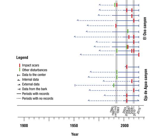
Figure 4 Reconstruction of flash floods in two canyons in Los Picos de Davis, Múzquiz, Coahuila. The horizontal lines in blue represent the length of each of the samples; in red, the impact scars; and in green, suppressions and eccentric growths. Gray bars indicate events with the highest number of trees affected.
Influence of Hurricanes on flash floods
According to historical information, extreme hydrometeorological events (hurricanes and cyclones) have affected the region of Los Picos de Davis by means of major flash floods (Table 3).
Table 3 Debris flows identified by dendrogeomorphological methods in the canyons of Los Picos de Davis, Múzquiz, Coahuila, and relation to hurricanes and torrential rains.
| Year with flash floods | Number of events | Type of tree damage | Weather data | |
|---|---|---|---|---|
| Annual rainfall (mm) | Tropical cyclones | |||
| 1990 | 1 | Loss of apex or burial | 728 | --- |
| 1991 | 1 | Tilting | 579 | --- |
| 1992 | 1 | Impact | 658 | --- |
| 1993 | 4 | Impact, los of apex or burial | 383 | --- |
| 2003 | 5 | Impact and tilting | 257 | "Claudette" tropical depression |
| 2004 | 2 | Impact, loss of apex or burial | 311 | --- |
| 2005 | 1 | Impact | 194 | --- |
| 2008 | 4 | Impact | 391 | "Dolly" hurricane (H1) |
| 2010 | 5 | Impact | 790 | "Alex" hurricane (H2) and “DOS” tropical depression |
| 2015 | 1 | Impact | 662 | |
Note: Historical data showed an average cumulative rainfall of 413 mm. The tropical cyclone record in the highest category was obtained from the NOAA database (https://www.nhc.noaa.gov/data/#tcr). H2 = Category II hurricane, H1 = Category I hurricane, Saffir-Simpson scale.
The most important and largest event due to the process of flash floods occurred in 2010. This year had the largest number of trees affected in both canyons of Los Picos de Davis (Figure 4) and the maximum intensity of the disturbance. The intrannual position showed that the event occurred at Middle Earlywood and Late Earlywood (ME and LE) (Figure 3b), which synchronize with intense rainfall of 691 mm (cumulative monthly average from April to September). These humidity conditions coincide with the presence of the category II Hurricane "Alex", the first hurricane of season 2010 in the Atlantic Ocean, coming from the Caribbean Sea (Table 3; Figure 5). Hurricane "Alex" crossed the state of Tamaulipas as a Category II hurricane, through the state of Nuevo León as a Category I hurricane and followed through San Luis Potosí with lower intensity. The hurricane also affected the state of Coahuila, where it caused torrential rains and significant flood damage. In Nuevo León, the hurricane caused human losses; therefore, it is considered one of the most powerful that has impacted northeastern Mexico in the last 40 years (Hernández & Bravo, 2010). In addition, after the hurricane, the tropical depression "DOS" made landfall in Texas and crossed the states of Tamaulipas, Nuevo León and Coahuila, causing extreme rains that intensified the damage caused by Hurricane "Alex" (Bravo, 2010).
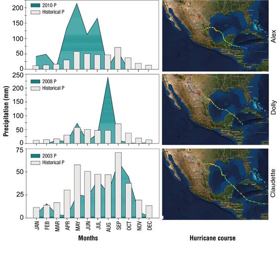
Figure 5 Relationship between historical average precipitation (PP) (1972-2013) and annual PP for the years 2010, 2008 and 2003, during the major events in Los Picos de Davis (left). Trajectory of Hurricanes Alex in 2010, Dolly in 2008 and Claudette in 2003 (right, images taken from NOAA, https://www.nhc.noaa.gov/data/#tcr). The red circle indicates the area of study.
The second flash flood was dated in 2008, the impact scars were dated at the Early Latewood (EL). Rainfall and hydrometeorological records suggest that this flash flood was triggered by the category I hurricane "Dolly" (Figure 5) which impacted directly on Los Picos de Davis. This hurricane was generated in July 2008 in the Atlantic Ocean, it entered the Gulf of Mexico and moved northwest, where it intensified to a Category II hurricane (Hernández & Bravo, 2008).
The third flash flood occurred in 2003 (Figure 5), with impact scars dated at Late Earlywood (LE). This event showed spatial-temporal synchronization, because it was identified in the two canyons. The triggering factor could have been the intense rain caused by Hurricane "Claudette", originating in the Atlantic, which kept its trajectory directly towards Los Picos de Davis in northwest Mexico (Figure 5). However, rainfall did not record a significant increase in relation to the historical average for that year (Figure 5).
This could be due to two aspects: (i) soil water saturation due to previous accumulated rainfall and (ii) rain caused by Hurricane "Claudette" could have been recorded in a short period, together with the occurrence of an extensive fire in the spring of 2003 affecting the two canyons, which consumed the vegetation that supported the soil and favored the triggering of the present floods.
The oldest flash floods were dated in 1992 and 1993; in both cases impact scars were identified (maximum dendrogeomorphic evidence). Although there is no record of hurricanes for those years in the region, annual rainfall of 658 mm and 383 mm, respectively, suggests the possible occurrence of two flash floods.
Conclusions
Growth rings of Pinus ponderosa recorded disturbances (impact scars, abrupt suppressions and compression wood) caused by flash floods in Los Picos de Davis, Múzquiz, Coahuila; therefore, the species has dendrogeomorphological potential. Extreme hydrometeorological events such as hurricanes and torrential summer rains are factors that could have triggered flash floods in the canyons. The results are novel for the northern region of Mexico and represent a starting point for further studies. The results are new to the north part of Mexico and represent a starting point for further studies. This type of dendrogeomorphological studies in the north of the country, which are considered border studies, can be useful in management plans, territorial planning and prevention of natural hazards, if the number of trees sampled is increased and other species are explored in order to extend the chronologies of geomorphological events in the region.

