


 texto en
  Inglés (pdf)
 Artículo en XML
 Referencias del artículo
 Enviar artículo por email
 Citado por SciELO
  Similares en
SciELO
Similares en
SciELO 
 Permalink
Introduction
The southwestern region of the state of Chihuahua, in the Sierra Madre Occidental (SMO), is an area of importance for forestry, biodiversity and the production of hydrological services (Comisión Nacional del Agua [CONAGUA], 2018). The forest management region of Guachochi, A.C. is located in this area, to which the forest management unit 0807 (UMAFOR 0807) involving the municipalities of Guachochi, Balleza, Batopilas, Urique, Guadalupe y Calvo, Nonoava and Rosario correspond, with a total area of 978 380 ha (Comisión Nacional Forestal [CONAFOR], 2009). In this region, mixed coniferous forests dominated by Pinus species of timber interest favor commercial exploitation, whose volumetric stocks are estimated at 60 million m3. The municipality of Guachochi owns 61.1 % of the total stocks of UMAFOR 0807, which is why it is considered one of the largest contributors for the state of Chihuahua to occupy the first places in the supply of volumes, which in some years reaches up to 1.2 million m3. At the same time, another aspect that occurs in the region, which covers 66 % of the state of Chihuahua, is the provision of water resources to both the Hydrological Region Bravo-Conchos (RH-24) and the Hydrological Region 10 (RH-10). The latter provides water resources to the irrigation districts of the state of Sinaloa through the basins of the Culiacan, Sinaloa and Fuerte rivers. The volumes of water produced in the region are approximately 3 800 million m3, of which about 693 million m3 are used for agricultural, livestock and domestic purposes (CONAGUA, 2018).
Changes in land use caused by intensive forest use and overgrazing, among other disturbances of anthropogenic origin, affect the hydrological cycle and, therefore, the drained volumes (Descroix, Nouevelot, & Vauclin, 2002). Based on the above, the determination of interannual and multiannual climate variability, its trends and the impact on water availability, as well as the influence that global warming may have in the region, is paramount (Feng & Fu, 2013).
Several precipitation reconstructions have been performed for some areas of Chihuahua (Diaz, Therrell, Stahle, & Cleaveland, 2002; Irby, Fulé, Yocom, & Villanueva, 2013; Villanueva et al., 2015a); however, there is still no information for the southwest of the state, particularly in UMAFOR 0807. Such information is important to define the impact that climate variability could have on biomass production of commercial species that, apparently, would be affected by climate change, as has already been determined for certain species in Chihuahua (Bickford, Fulé, & Kolb, 2011; Castruita-Esparza et al., 2019).
The objective of this study was to develop a climate reconstruction with dendrochronological series distributed in the southwest of Chihuahua and that have influence on the volumes of water that drains to the irrigation districts in the state of Sinaloa and to the eastern slope of the Conchos river basin. In addition, the influence that general circulation modes exert on historical climate behavior was determined, and the possible relationship between drought indices, such as the Standardized Precipitation Evapotranspiration Index (SPEI) and the Palmer Drought Severity Index (PDSI), and regional dendrochronological indices was analyzed.
Materials and methods
Study area
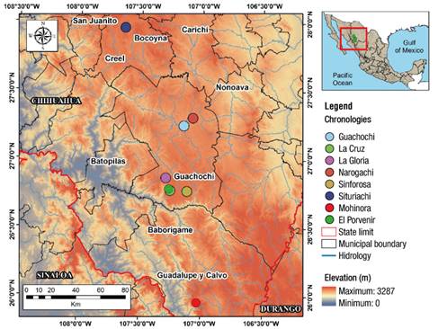
The study area is located in the mixed temperate forest of the SMO in the southwest of Chihuahua (Figure 1). The dominant climate is of the types C(E)w1, C(E)w2 and C(E)w2 (x’), which correspond to semi-cold climates, sub-humid with summer rains, subtype of medium humidity, where the winter precipitation is greater than 10.2 % (Garcia, 2004). The average annual precipitation is 700 mm with fluctuations between 400 and 1 100 mm (Instituto Mexicano de Tecnología del Agua [IMTA], 2013). The area is dominated by acidic and basic extrusive igneous rocks that give rise to soils classified as regosols; the dominant vegetation is pine forest (50 %), followed by pine-oak (12 %) and the rest by oak woodlands, oak-pine forests, grasslands, and crop growing areas (CONAFOR, 2009).
Sampling of growth cores
Eight sampling sites were located in the southwest of the state of Chihuahua; the selected sites have mixed temperate forest vegetation dominated by pine and oak species; in two of them Pinus lumholtzii B. L. Rob. & Fernald dominates, three more with Pinus arizonica Engelm., one with Pinus leiophylla Schiede ex Schltdl. & Cham., and two with Pseudotsuga menziesii (Mirb.) Franco (Table 1). In regional studies, the integration of various species in a basin or hydrological region allows to capture hydroclimatic fluctuations with greater accuracy and substantiate the influence that global circulatory phenomena exert (Woodhouse & Lukas, 2006).
Table 1 Geographic location of study sites in the southwest of the state of Chihuahua.
| Site | Key | North latitude | West Greenwich Longitude | Elevation (m) | Sampled species |
|---|---|---|---|---|---|
| Guachochi | GUA | 27° 14' 48" | 107° 08' 50.5" | 2 113 | Pinus lumholtzii |
| Narogachi | NAR | 27° 18' 12" | 107° 04' 29.0" | 2 285 | P. lumholtzii |
| La Cruz | LAC | 26° 46' 20" | 107° 15' 14.0" | 2 495 | Pinus arizonica |
| Porvenir | POR | 26° 48' 52" | 107° 15' 49.1" | 2 495 | P. arizonica + Abies durangensis |
| Sinforosa | SIN | 26° 45' 59" | 107° 06' 55.0" | 2 490 | Pinus leiophylla |
| La Gloria | GLO | 28° 51' 52" | 107° 17' 21.6" | 2 313 | Pseudotsuga menziesii |
| Situriachi | SIT | 27° 57' 35" | 107° 38' 20.3" | 2 412 | P. arizonica |
| Cerro Mohinora | MOH | 25° 57' 16" | 107° 01' 38.0" | 2 900 | P. menziesii |
The sampling of the trees was selective and obtained from two to three increment cores per tree; the cross sections were obtained from dead trees or stumps from previous logging. The number of trees sampled per site fluctuated between 40 and 60 individuals. The samples were processed in the Laboratorio de Dendrocronología del Instituto Nacional de Investigaciones Forestales, Agrícolas y Pecuarias (INIFAP) according to conventional dendrochronological methods (Stokes & Smiley, 1968). The quality of the dating of the series was determined with the COFECHA program (Holmes, 1983) and the process of standardization of the series to obtain total ring width, earlywood width and latewood width (RW, EW and LW, respectively) was performed with the ARSTAN program (Cook, 1987). The quality of the dendrochronological series was based on the values of series intercorrelation, mean sensitivity and signal-to-noise ratio (Fritts, 1976).
To analyze the common climate response between the series, a simple correlation and a Principal Component Analysis were developed to determine the series with the same variability (those loaded in the first principal component and with high correlation), in order to generate a series with regional representativeness. From each dendrochronological series gridded precipitation was obtained from the area closest to the collection site, based on records and estimated values of rain from CONAGUA and covering the period 1950-2015; the grids selected were 42985, 42986, 43304, 44586, 44906 and 42140 (Terán, 2010). Rainfall records were averaged at a monthly level to generate a regional series of precipitation representative of the southwest of Chihuahua.
The response function between the regional total ring-width chronology and the average rainfall series was analyzed using both the DENDROCLIM program (Biondi & Weikul, 2004) and simple correlations, considering a seasonal period of 18 months of rain (six months prior to the year of growth and 12 months during the year of growth). The cumulative precipitation of the seasonal period with significant association (P < 0.01) was correlated with the total ring-width indices in their standard and residual version and a linear model was generated for reconstruction purposes.
The generated model was calibrated in half of the climate records and verified in the other half, using the Verify subroutine of the Dendrochronology Program Library of the University of Arizona (Holmes, 2001). The calibrated and verified regression equation was used in seasonal rain reconstruction, to which a flexible ten-year spline was adjusted to highlight high and low frequency events (Esper, Cook, Krusk, Peters, & Schweingruber, 2003); a Power Spectrum Analysis was also performed to determine the presence of significant frequencies (Bunn et al., 2018).
The reconstructed precipitation series was correlated with El Niño Southern Oscillation (ENSO) indices such as the Southern Oscillation Index (SOI), the Multivariate ENSO Index (MEI) and the Tropical Rainfall Index (TRI) (Wolter & Timlin, 2011; Wright, 1979), as well as with the Pacific Decadal Oscillation (PDO) (Mantua, 2017) and the Atlantic Multidecadal Oscillation (AMO) indices (Endfield, Mestas-Núñez, & Trimble, 2001).
In order to determine whether the annual growths of the tree species involved are a proxy for the intensity and duration of documented historical droughts in the region, the total ring growth series was related to drought indices such as the Reconstructed Palmer Drought Severity Index (PDSI) (Stahle et al., 2016) and the Standardized Precipitation Evapotranspiration Index (SPEI) (Vicente-Serrano, Begueria, & Lopez-Moreno, 2010).
Finally, the normalized volumes of runoff recorded in the basins of the Fuerte, Sinaloa and Conchos rivers in Chihuahua were related to the indices of the southwest Chihuahua growth series by simple correlation analysis with hydrometric data obtained from the Banco Nacional de Aguas Superficiales (CONAGUA, 2019). For the Fuerte river, data was obtained from station 10037 Huites, whose recording period includes 1942-1992, and for the Conchos river data was used from stations 24195 San Antonio and 36060 Los Angeles with recording periods of 1943-1986 and 1954-2014, respectively. These data were used to determine the degree of association of interannual variation in runoff and growths of the tree species involved.
Results
Dendrochronological Series
Eight ring-width chronologies were generated involving between 40 and 135 increment cores. These showed intercorrelations between series in a range of 0.54 to 0.73 (>0.328 required by COFECHA for suitable dating) and lengths of 108 to 347 years (Table 2). Figure 2 shows that the series had a similar climatic behavior for the common period (1910-2005). Correlations in reference to the chronology of the GUA site were greater than 0.5 (P < 0.01), although the lowest correlations corresponded to the MOH sites (r = 0.238, P < 0.01) and POR (r = 0.344, P < 0.01), respectively.
Table 2 Extension of the dendrochronological series distributed in the northwest of the state of Chihuahua.
| Site | Site key | Sampled species | Series length (years) | Chronology type |
|---|---|---|---|---|
| Guachochi | GUA | Pinus lumholtzii | 1806-2016 (211) | RW |
| Narogachi | NAR | P. lumholtzii | 1875-2017 (143) | RW |
| La Cruz | LAC | Pinus arizonica | 1907-2016 (110) | RW, EW, LW |
| Porvenir | POR | P. arizonica + Abies durangensis | 1897-2013 (117) | RW, EW, LW |
| Sinforosa | SIN | Pinus leiophylla | 1887-2016 (130) | RW, EW, LW |
| La Gloria | GLO | Pseudotsuga menziesii | 1790-2014 (225) | RW, EW, LW |
| Situriachi | SIT | P. arizonica | 1910-2017 (108) | RW, EW, LW |
| Cerro Mohinora | MOH | P. menziesii | 1659-2005 (347) | RW, EW, LW |
RW = total ring width, EW = earlywood width, LW = latewood width.
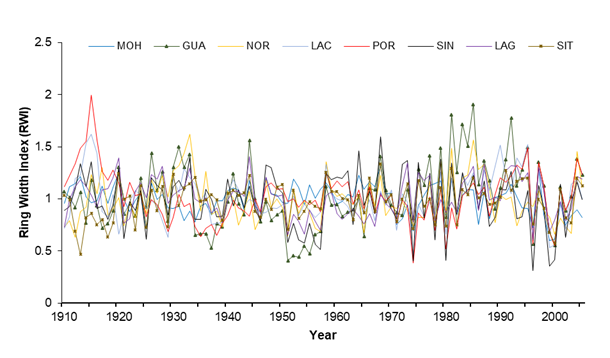
Figure 2 Behavior of the total ring-width series of the common period (1910-2005) at sites in the southwest of the state of Chihuahua. GUA = Guachochi, NAR = Narogachi, LAC = La Cruz, POR = Porvenir, SIN = Sinforosa, GLO = La Gloria, SIT = Situriachi, MOH = Cerro Mohinora.
According to the Principal Component Analysis shown in Figure 3, the first component accounts for 51.8 % of the common variance, with an eigenvalue of 4.5, while components 2 and 3 contributed 14.5 % and 10.2 % of the variance, respectively, representing 76.5 % of the cumulative total variance. The MOH and POR series showed different behavior to the rest of the chronologies; therefore, in order to integrate the regional chronology, they were excluded from this analysis. The LAC series was not ruled out because it presented high correlation together with the other series, which translates into the same variability.

Figure 3 Main components of the chronologies generated in the southwest of the state of Chihuahua. The first component explains 51.8 % of the common variance.
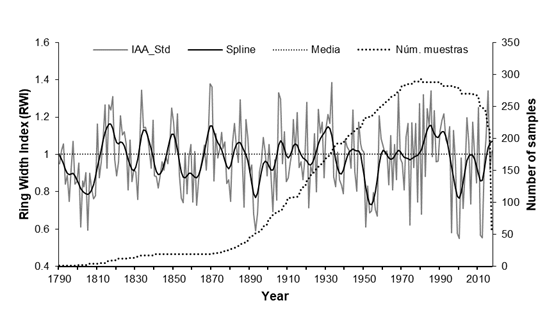
According to Figure 4, the regional series of total ring-width extends from 1790 to 2017 (228 years), where the number of samples to generate the annual indices was 310 and only 16 of them (5 %) came from cross sections. The sample size increases from 1820 with more than 12 radii, and the Expressed Population Signal (EPS) exceeds 0.85 (Wigley, Brifa, & Jones, 1984). This series shows high interannual and multi-year variation, supported by the intercorrelation parameters between series (0.59), average sensitivity (0.352) and signal-to-noise ratio (27.7).
Response function analysis
The DENDROCLIM program determined that the months of precipitation with positive influence on the annual growth series were from August of the previous year to July of the current year of growth; however, the significant association (P < 0.05) happened from August of the previous year to May of the current year of growth, with correlation values of 0.298, 0.357, 0.349, 0.341, 0.497, 0.461, 0.446, 0.408, 0.425 and 0.328, respectively. Based on this information, using simple correlation analysis, it was determined that the period of accumulated precipitation with the greatest influence on annual growth was from September of the previous year to July of the current year of growth. For reconstruction purposes, a calibration was performed in the total climate records (1951-2015), as well as in half of them (1951-1982, 1983-2015); the information is shown in Table 3.
Table 3 Calibration and statistical periods of regression between precipitation records and indices of the standard total ring-width chronology, for the southwest of the state of Chihuahua.
| Period | Adjusted R2 | Coefficient (mm) | Standard Error (mm) | T-statistic (Ho: Β = 0) | Regression (probability) | |||
|---|---|---|---|---|---|---|---|---|
| Β 0 | Β 1 | Β o | Β 1 | Β 0 | Β 1 | |||
| 1951-2015 | 0.651 | 28.9 | 522.0 | 47.2 | 47.5 | 0.61 | 10.98** | 0.000 |
| 1951-1982 | 0.780 | -103.1 | 655.9 | 60.2 | 62.4 | -1.7* | 10.5** | 0.000 |
| 1983-2015 | 0.537 | 142.8 | 413.2 | 68.4 | 66.9 | 2.08** | 6.20** | 0.000 |
Adjusted R2 according to degrees of freedom. Significance: * P < 0.05; ** P < 0.01.
The estimated values of precipitation were used in the verification process of the model; that is to say, the subperiod of 1951-1982 was used to calibrate the model and the 1983-2015 to validate it, then the 1983-2015 subperiod was calibrated and the 1951-1982 was verified (Table 4). Because the verification process was significant for all statistical parameters in both subperiods, the total precipitation records were used to generate the following linear reconstruction model:
where,
Yi |
reconstructed precipitation of the period from September of the previous year to July of the current year of growth for a specific year |
Xi |
annual total ring-width index of the standard regional chronology representative of the southwestern region of Chihuahua |
Table 4 Verification statistics for the cumulative seasonal precipitation in September of the previous year to July of the current year of growth, for the southwest of the state of Chihuahua.
| Period | Pearson Correlation Coefficient | Reduction of Error1 | t value | Sign test2 | First negative difference3 |
|---|---|---|---|---|---|
| 1951-1982 | 0.89 | 0.69 | 5.20 | 4 | 3 |
| 1983-2015 | 0.74 | 0.41 | 4.63 | 7 | 8 |
1There is no test of significance for this statistic, but any positive results indicate that the reconstruction contributes with unique paleoclimatic information (Fritts, 1976). 2It relates the number of coincidences and disagreements between the observed and reconstructed data and applies an association statistic between the two, known as the "t-test" (Fritts, 1976). 3First difference between observed and reconstructed data (t- t-1); the transformation removes trends that may affect the correlation coefficient (Fritts, 1976). All values were significant (P < 0.05).
Figure 5 shows that the reconstruction of precipitation extends from 1790 to 2015 with high interannual and multiannual variation. The dry periods detected in the reconstruction were from 1795 to 1809, 1854 to 1864, 1892 to 1896, 1951 to 1957, 1996 to 2003 and 2011 to 2013, where the drier years (one standard deviation below the mean, estimated in 540.2 mm for the period September-July) are 1801, 1805, 1887, 1893, 1894, 1902, 1921, 1951, 1957, 1974, 1980, 1996, 1999, 2000, 2011 and 2012. The wetter periods occurred from 1812 to 1825, 1832 to 1839, 1848 to 1852, 1866 to 1875, 1928 to 1933 and from 1982 to 1993, with the wettest years (a standard deviation above average) being 1818, 1833, 1869, 1870, 1885, 1905, 1906, 1920, 1933, 1968, 1981, 1985 and 2015.
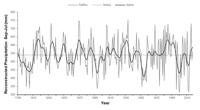
Figure 5 Reconstruction of seasonal precipitation September-July, representative of the southwestern region of the state of Chihuahua.
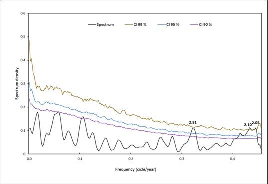
According to the Power Spectrum Analysis of Figure 6, the reconstructed precipitation series shows significant frequencies in periods close to 2.0 years.
Response of the reconstructed series to indices of general circulation modes and drought indices
Table 5 shows that the association between the regional total ring-width series, circulatory mode indices (ENSO, PDO and AMO) and drought indices (PDSI and SPEI) was significant. The ability to generate maps of reconstructed PDSI at the local, regional or national level, for a year or period of years, makes it possible to determine the dominant hydrological condition at an annual or multi-annual level during the extremely dry and wet periods, as occurred for the extraordinary drought from 1951 to 1957 and the wet period from 1928 to 1933 (Figure 5).
Table 5 Association between indices of general circulation modes and indices of the regional ring-width chronology for the Southwest of Chihuahua.
| Index | Months | Period (years) | Correlation (r) | |
|---|---|---|---|---|
| RWI | Probability | |||
| Reconstructed SOI | November-February | 1791-1977 (187) | -0.58 | 0.000 |
| SOI | July-April | 1857-2017 (151) | -0.48 | 0.000 |
| MEI | October-April | 1951-2017 (67) | 0.46 | 0.000 |
| TRI | July-April | 1895-1994 (100) | 0.49 | 0.000 |
| PDO | August-October | 1949-2015 (67) | 0.47 | 0.000 |
| AMO | March-June | 1857-2015 (159) | 0.18 | 0.020 |
| PDSI | June-August | 1900-2012 (113) | 0.68 | 0.000 |
| SPEI | August-June | 1951-2017 (67) | 0.71 | 0.000 |
RWI = ring width index. SOI = Southern Oscillation Index (Stahle et al ., 1998); instrumental SOI (Allan et al., 1996); MEI = ENSO multivariate Index (El Niño Southern Oscillation) (Wolter & Tilmin, 1993); TRI = Tropical rain Index (Wright, 1979); PDO = Pacific Decadal Oscillation (Mantua, 2017); AMO = Atlantic Multidecadal Oscillation (van Oldenborgh, te Raa, Dijkstra, & Philip, 2009); reconstructed PDSI = Palmer Drought Severity Index (Stahle et al., 2016); SPEI = Standardized Precipitation Evapotranspiration Index (Vicente-Serrano et al ., 2010).
Regional series response to water production volumes
The representative regional chronology of the Southwest of Chihuahua showed significant association with the volumes of water draining to the Pacific coastal plain, in the seasonal period September-August (r = 0.77, P = 0.000, n = 50, 1943-1992); in particular, with the volumes recorded in the Fuerte river basin. This association, although significant, was lower for runoff recorded in tributaries of the Conchos river basin, where the association was only 0.46 (P = 0.001, n = 44, 1943-1986).
Discussion
Coniferous species present in the slopes of the SMO of the Southwest of Chihuahua, among which are P. lumholtzii, P. arizonica, P. leiophylla, P. menziesii and A. durangensis, have similar growth in dendrochronological terms, since their growth series showed associations greater than 0.5 with respect to the Guachochi chronology, which was considered as a reference in this study. This similar response between the series implies that the species involved capture the influence of climatic phenomena that impact an entire region. Although interannual radial growths vary by species, they show similar fluctuations in function of a common limiting factor such as precipitation (Fritts, 1976). This common response has made it possible to reconstruct historical droughts with national or international impact (Stahle et al., 2011).
The analysis of principal components in a dendrochronological network, for the selection of the series that most contribute to a common climate variance in hydroclimatic reconstruction, is a methodology used for several decades; its use has been magnified, since an individual chronology can hardly capture all climate variability in a wide region, where ecological and topographic conditions usually generate fluctuations in behavior (Duchesne, D'Orangeville, Ouimet, Joule, & Kneeshaw, 2017). The integration of various chronologies increases the sample size, dilutes the influence of disturbances of natural and anthropogenic origin (St. George, 2014) and allows the prediction of the growth response of forest species to environmental changes in a region (Drobyshev, Gewehr, Berninger, & Bergeron, 2013).
In Mexico, the integration of dendrochronological series through principal components has been used for precipitation reconstructions in the Chihuahua-Durango region (Cleaveland, Stahle, Therrell, Villanueva-Diaz, & Burns, 2003; Diaz et al., 2002; Villanueva et al., 2015a) and other parts of the country (Stahle et al., 2016; Villanueva et al., 2015b). Thus, the use of dendrochronological networks has allowed the reconstruction of streamflows in basins of northern Mexico (Villanueva et al., 2017; Woodhouse, Stahle, & Villanueva, 2012), particularly those that drain to the Pacific coast, where irrigation districts are located, whose water originates in SMO basins (CONAGUA, 2018).
The hydroclimatic variability in the southwest of Chihuahua, particularly in UMAFOR 0807, had not been documented; however, its behavior is similar to that found in other regions of the state (Villanueva et al., 2015b). The discrepancy in other reconstructions of seasonal precipitation in the state of Chihuahua lies in the location of the study and in the reconstructed period; for example, the seasonal reconstruction performed by Diaz et al. (2003) covers the November-April period and doesn’t get to detect some of the most intense droughts that occurred in the southwest of Chihuahua during the summer. A similar situation is observed in the study of the Basaseachi National Park region, where the reconstruction of seasonal precipitation October-April does not agree with most of the driest periods detected in the present study that includes a larger seasonal period (Irby et al., 2013).
The historic impact of drought in the state of Chihuahua, prior to the 20th century, is based heavily on colonial archives (Endfield & Tejedo, 2006); however, this information may not be representative of other regions of the state, where the impact of drought could be different in terms of food production and its impact on the population (Easterling et al., 2001). In this way, it is important to determine the events and periods of drought in regions such as the southwest of Chihuahua that are sources of water provision to agricultural areas of great economic importance; in addition, in this region of forestry excellence, biomass production, translated in timber yield, largely depends on the dominant climatic conditions (CONAFOR, 2009) and could be reduced by the effect of global warming (Bickford et al., 2011; Castruita-Esparza et al., 2019).
The climatic significance of the region is manifested by the influence that atmospheric circulatory modes have and that determine the interannual variability and multiannual climate in the region; for example, the ENSO phenomenon through its indices (SOI, MEI, and TRI) shows significant effects on the annual radial increase of forest species, with a significant association close to 0.5, from July of the previous year to April of the current year of growth and of 0.58 from November to February, only surpassed by some of the sites of Durango, where the association reaches a value of 0.63 (Villanueva et al., 2017). The association with this phenomenon, which is presented indirectly in the region, through its teleconnection, is one of the most clear and meaningful in North America, which favors the presence of increased precipitation during the warm phase of this phenomenon, and drought conditions in its cold phase (Mendez & Magaña, 2010; Stahle et al., 1998; Torbenson et al., 2019). The presence of significant frequencies in the reconstruction around two and three years is within the normal frequencies described for ENSO in the range of two to ten years (Li et al., 2011), which may explain the high variability of precipitation.
The association between the PDO Index, in the period from August of the previous year to October of the current year of growth, and the dendrochronological indices showed a significant value of 0.47. ENSO's interaction with PDO is well known in Mexico (Pavia, Graef, & Reyes, 2006) and its influence has been demonstrated in dendroclimatic reconstructions in Baja California (Meko et al., 2013). Recent studies have determined the influence of ENSO on the sea surface temperature in the tropical Pacific, in both interannual and decadal levels (Kumar & Hu, 2014). The latter is better known as PDO (Mantua, 2017), a pattern that results from fluctuations in the low pressure center “Aleutian Low” in the North Pacific, either intrinsically or through ENSO teleconnection (Jia & Ge, 2017). The relationship between the two circulatory phenomena could be determined in detail for this region of the country, involving a greater number of climatic variables.
The relationship between the regional dendrochronological series of total ring-width in the southwest of Chihuahua with drought indices was highly significant with the reconstructed PDSI from the June-August period (r = 0.68, P < 0.01, 1900-2012), indicating that tree species in this region constitute a historical proxy of the dominant drought conditions. This result is corroborated by the association of the growth series with average indices of the SPEI for the period August of the previous year-June of the current year of growth (r = 0.71, P < 0.01, 1951-2017). The results are more relevant considering that the growths are significantly correlated with the streamflow in the Fuerte river basin which are used for irrigation purposes, as well as with the streamflow that feed tributaries of the Conchos river and that constitute the source of water for various irrigation districts.
Conclusions
The southwest of the state of Chihuahua is a climatically homogeneous region and the development of a dendrochronological network, composed by various tree species and integrated into a regional chronology, allowed to capture the interannual and multiannual variability of the climate. The dendrochronological series had significant influence from ENSO (El Niño Southern Oscillation) in the period from July of the previous year to April of the current year of growth. The PDO (Pacific Decadal Oscillation) index had a significant influence on precipitation from August of the previous year to October of the current year of growth. The relationship between the regional ring-width series and drought indices (Standardized Precipitation Evapotranspiration Index [SPEI] and Palmer Drought Severity Index [PDSI]) was significant. This relationship indicates the potential of the growth rings to define drought conditions of the last centuries in the region and, therefore, of the production of water resources in irrigation districts of basins that drain into the Pacific coast and the plateau of the Chihuahua desert.

