


 texto en
  Inglés (pdf)
 Artículo en XML
 Referencias del artículo
 Enviar artículo por email
 Citado por SciELO
  Similares en
SciELO
Similares en
SciELO 
 Permalink
Introduction
Ethnopedology is the science dealing with how peasants, indigenous people or local farmers perceive, know, use and manage soils and other natural resources (Bautista & Zinck, 2010). Soil sciences have been developed for less than 150 years (Hartemink, Krasilnikov, & Bockheim, 2013). Throughout this period, scientific progress has been made to solve numerous problems; however, since man first appeared on the face of the earth (more than 40,000 years ago), wisdom and experience have been developed to face a variety of agricultural and environmental problems in a broad sense (Brevik & Hartemink, 2010; Hartemink et al., 2013).
The virtues of local knowledge about soils have been recognized over time. For example, in the past, local knowledge about soil corresponded mainly to the arable layer (Bautista, Jiménez-Osornio, Navarro-Alberto, Manu, & Lozano, 2003, Ettema, 1994), while currently there is knowledge about the sub-surface horizons (Bautista, Diáz-Garrido, Castillo-González, & Zinck, 2005, Bautista & Zinck, 2010, Cruz, Ortiz, Gutiérrez, & Villegas, 2008, Licona-Vargas, Ortiz-Solorio, Gutiérrez-Castorena, & Manzo-Ramos, 2006, Mariles-Flores, Ortiz-Solorio, Gutiérrez-Castorena, Sánchez-Guzmán, & Cano-García, 2016). Local knowledge about soils is of great importance in adopting and adapting agricultural practices (Bautista, García, & Mizrahi, 2005, Bautista & Zinck, 2010, Krasilnikov & Tabor, 2003); in addition, it can be organized into classification schemes such as international ones (Bautista & Zinck, 2010).
In the state of Michoacán, Mexico, there is local and peasant knowledge about soil; for example, spatial relationships between land classes and soils have been reported (Barrera-Bassols, Zinck, & Van Ranst, 2009); there have been reports on the similarities and differences between land classes and soil classification according to the FAO (Ortiz-Solorio & Gutiérrez-Castorena, 1999; Sotelo-Ruiz & Ortiz-Solorio; 2001), as well as on the P'urhépechas names of soils (Alarcón-Cháires, 2010; Bedolla-Ochoa, Bautista, & Gallegos, 2018). However, with the exception of Alcalá, Ortiz, & Gutiérrez (2001), there are few studies comparing and harmonizing the denomination or description that peasants make of various soil classes based on properties determined in the laboratory.
The municipality of La Huacana, Michoacán, is located within the transverse volcanic system, where there are several soils buried due to volcanic ash emissions; thus, it is to be expected that local residents have knowledge about the surface soils and perhaps about the buried soils. The Zicuirán-Infiernillo Biosphere Reserve is located in La Huacana, and it is a globally important biological conservation area (Ihl, Bautista, & Mendoza, 2017), so it is vital to use the soil carefully in the buffer area.
The objectives of this study were to establish whether the names peasants use for soil classes are associated with their physical and chemical properties, as well as to identify the main properties that allow the formation of soil classes. It is expected that the harmonization of local knowledge with that obtained systematically will contribute to a faster understanding of soils.
Materials and methods
Study area
This study was conducted in the municipality of La Huacana, Michoacán, Mexico. The agricultural area is located at an average elevation of 481 m a.s.l.; the climate is warm sub-humid (Aw0) with rain during the summer. The average annual temperature is 28 °C (minimum of 10 °C and maximum of 44 °C), and the average annual rainfall is 767 mm (Comisión Nacional del Agua [CONAGUA], 2014). Soil cover is mainly low deciduous forest (Ihl et al., 2017). Inhabitants are mainly peasants, who are a mixture of descendants of P'urhépechas, Italians and Spaniards. The main productive activities are livestock breeding (extensive and, to a lesser extent, stabled), self-consumption agriculture and fishing (Ihl et al., 2017).
Peasant and technical knowledge
The 35 peasants interviewed had a low level of technical skills, average elementary school completion and 38 years’ field experience on average. The interview was semi-structured on the use, management, names, characteristics and attributes of soil classes (Ortiz, Pájaro-Huertas, & Ordaz, 1990; Santos & Molina, 2011); the number of interviews accounted for 10 % of the peasant population.
Together with the farmers, 31 trial pits were dug 1.5 m deep or to where rock was found, including all geoforms (mountains, hills, plains and valleys) and land uses (agriculture, pasture and forest). Thirty-one soil profiles were described using the Food and Agriculture Organization of the United Nations handbook (FAO, 2009), including peasant soil classes such as Tocura, Charanda, Barrosa, Polvilla and others. In the 31 profiles, samples were taken by horizons or stratum according to each case, obtaining a total of 122 samples. The samples were dried at room temperature and in the shade, and sieved with a 10-mesh sieve (particles of 2 mm or less).
The analyses were: bulk density (Gandoy, 1991), particle size distribution (Okalebo, Gathua, & Woomer, 1993), dry and wet color (Gandoy, 1991), pH (Lean, 1982), organic matter (OM) (Nelson & Sommers, 1982), cation exchange capacity (CEC) and interchangeable cations (United States Department of Agriculture [USDA], 1996).
Data analysis
A discriminant analysis was used to verify whether the names assigned to soil classes in the horizons of the profiles, used by the peasants, were related to 15 measured physical and chemical soil properties. The names of the classes were the dependent variables, and the chemical and physical properties were the independent variables. A principal component analysis was also made to identify the physical and chemical properties of soils that allow the formation of groups, in this case, peasant soil classes. In addition, a graph was constructed with the 31 profiles indicating their soil classes by horizon and substrate using the "Algorithms for quantitative pedology" package in R program (Beaudette, Roudier, & O'Geen, 2013).
The analysis of variance was performed with the Kruskal-Wallis test (P = 0.05), in which the medians are compared because the populations were not Gaussian (Kruskal & Wallis, 1952).
Results and discussion
Validation of traditional knowledge
Table 1 presents the eight soil classes that peasants identified at horizon or substrate level: Barrosa, Cementante, Charanda, Polvilla, Tocura, Tepetate, Cascajo and Balastre. The properties of the soils that the peasants used in the field were: dry and wet consistency, texture, color and coarse fragments. In addition, the peasants defined soil use by the accessibility of the land and water availability.
Table 1 Attributes used by the peasants of La Huacana, Michoacán, to define soil classes.
| Attribute | Soil classes | ||||
|---|---|---|---|---|---|
| Tocura | Barrosa | Polvilla | Charanda | Cementante | |
| Consistency | "Rigid.” Slightly hard laminar structure. | "Heavy, cracks when dry." Very plastic and extremely hard. | "Loose and soft." Non-coherent, with semi-spherical aggregates easy to disintegrate. | "Hard, tight and with lots of stone." Its structure resists pressure. | "Firm, very hard." It can break apart in your hands into smaller structures. |
| Texture | Muddy-sandy | Clay | Sandy | Clay | Sandy |
| Color | Reddish brown | Dark gray | Black | Reddish | Yellow |
| Moisture | Slightly moist | Excess moisture | Very dry | Moist | Dry |
| Drainage | "Absorbs water moderately”. Moderate drainage. | "Absorbs a lot of water; even ponds it." Deficient drainage. | "It lets water run fast." Good drainage. | "It’s hungry for water." Absorbs water. Deficient drainage. | "Water runs, it hardly absorbs it." Good drainage. |
The discriminant analysis revealed that 76.23 % of all cases (soil horizons with their traditional names) were correctly assigned; thus, it can be said that the names of the soil classes are supported by their physical and chemical properties (Table 2). The discriminant analysis indicated that the Cementante and Tocura classes were 100 % correctly assigned because they are not mixed with sand from the El Jorullo volcano; it also allowed mathematically validating that the traditional empirical knowledge, to assign soil class names, does consider physical and chemical properties.
Table 2 Cross validation of cases of assigning soil classes to groups formed on the basis of physical and chemical soil properties. Cases classified correctly: 76.23 %.
| Soil class | Samples | Barrosa | Cementante | Charanda | Polvilla | Tocura |
|---|---|---|---|---|---|---|
| Barrosa | 45 | 36 | 0 | 3 | 3 | 3 |
| (80.00 %) | (0.00 %) | (6.67 %) | (6.67 %) | (6.67 %) | ||
| Cementante | 6 | 0 | 6 | 0 | 0 | 0 |
| (0.00 %) | (100 %) | (0.00 %) | (0.00 %) | (0.00 %) | ||
| Charanda | 34 | 3 | 1 | 26 | 3 | 1 |
| (8.82 %) | (2.94 %) | (76.47 %) | (8.82 %) | (2.94 %) | ||
| Polvilla | 33 | 1 | 4 | 7 | 21 | 0 |
| (3.03 %) | (12.12 %) | (21.21 %) | (63.64 %) | (0.00 %) | ||
| Tocura | 4 | 0 | 0 | 0 | 0 | 4 |
| (0.00 %) | (0.00 %) | (0.00 %) | (0.00 %) | (100 %) |
On the other hand, the principal component analysis revealed that the first component explained 41.3 % and was defined by sand, Na, pH and clay (Figure 1). According to the second component, which explained 12.9 %, the properties that formed the groups by soil class were pH, OM, Na and sand. The third component explained 9.4 % and the properties of greatest weight were pH, OM, Na, CEC, sands and clay. These three components explained a total of 63.6 % of the variance.
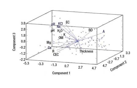
Figure 1 Analysis of the three principal components that explain the formation of soil groups. BD = bulk density, EC = electrical conductivity, OM = organic matter, CEC = cation exchange capacity, C = clay, S = sand, K = interchangeable potassium, Mg = interchangeable magnesium, Ca = interchangeable calcium, Na = interchangeable sodium, pH H2O = pH value measured in water, pH KCl = pH value measured in KCl.
Description of peasant soil classes
The name Polvilla is assigned to black sand emitted by the El Jorullo volcano during the 1759-1774 period. Polvilla, therefore, is found in the upper part of the soils, covering the Barrosa and Charanda classes (Figure 2).

The Polvilla and Barrosa soil classes have wide-ranging sand and clay percentages because they are buried soils; the contact point between them is a mixture. Pedogenetic processes have already formed horizons (upper and lower) different from those of origin; in other places in Michoacán, these horizons are called "Revuelta" (Maldonado, Alcalá, González, & Ayala, 2014).
The term Polvilla used in this text is very different from that reported by Maldonado et al. (2014) for soil classes surrounding the city of Morelia, Michoacán. The Barrosa soil class corresponds to Vertisols (Krasilnikov et al., 2013; Torres-Guerrero, Gutiérrez-Castorena, Ortiz-Solorio, & Gutiérrez-Castorena, 2016), clay soils with high cation exchange capacity. However, the Barrosa soil class (peasants call it Barro) escapes the typical concept of Vertisols, since some horizons contain less clay and, therefore, a lower capacity for cation exchange due to contact with the Polvilla soil class. The Barrosa class has the highest electrical conductivity, pH, magnesium and sodium values.
The term Charanda "Echeri charanda", of P'urhépecha origin, corresponds to reddish and clay soils, often corresponding to Luvisols (Carney, 1990), but they are also reported as Acrisols (Bravo et al., 2011), which are red soils with Bt horizon. The Charanda soil class varies considerably in particle size distribution (Figure 3), due to contact horizons with Polvilla. It also has wide intervals in Mg (Figure 4), K (Figure 5), EC and pH. In most cases there is a Bt horizon, hence this soil class corresponds to Luvisols and to a lesser extent to Cambisols. The Charanda class is a highly erodible soil; the name is also given to reddish sediments (Fisher, Pollard, Israde-Alcántara, Garduño-Monroy, & Banerjee, 2003).
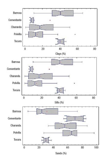
Figure 3 Analysis of variance (Kruskal-Wallis, P = 0.05) of particle percentages by soil class in La Huacana, Michoacán.
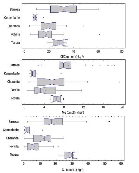
Figure 4 Analysis of variance (Kruskal-Wallis, P = 0.05) of cation exchange capacity (CEC) and interchangeable calcium and magnesium by soil classes in La Huacana, Michoacán.
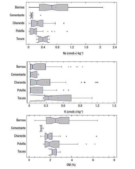
Figure 5 Analysis of variance (Kruskal-Wallis, P = 0.05) of organic matter (OM) and interchangeable sodium and potassium by soil classes in La Huacana, Michoacán.
The Tocura soil class has not been reported; it corresponds to reddish brown soil with laminar structure, a median of 40 % in sand and silt (Figure 3), CEC around 25 cmol·kg-1 and has the highest contents of interchangeable calcium (Figure 4) and potassium (Figure 5). This soil class has a Bt horizon, so it qualifies as a Luvisol.
The Cementante soil class is yellow, and has hard consistency, strong aggregates and sandy texture (Table 1). This soil has the lowest percentages of clay and silt (Figure 3), its CEC is the lowest (Figure 4), and it has the lowest contents of interchangeable cations (Figure 5) and organic matter. This soil class had not been reported; it corresponds to an Arenosol according to the IUSS Working Group WRB (2014).
Other soil classes with a smaller surface area were found in the study area, such as: Balastre, which corresponds to gravel and coarse fragments with a scant quantity of particles smaller than 2 mm in diameter; eroded Tepetates without fine earth, and Cascajo, which consists of coarse fragments without fine earth.
Conclusions
The methodology allowed determining that the peasants of La Huacana, Michoacán, have a three-dimensional perspective of the soil because they recognize the subsurface horizons, an aspect reported for the first time. The soil class names correspond to horizons and have a physical and chemical basis; the properties that define them were sand and clay percentages, organic matter, cation exchange capacity, pH and interchangeable Na. The Tocura and Cementante soil classes are characterized for the first time, according to their chemical and physical properties. Polvilla, which is black sand from the volcano, is being incorporated into the Barrosa and Charanda classes, which has already given rise to a horizon called "mezclada" that not all peasants recognize, but that in other parts of the state they call "revuelta". Proven local knowledge can be a very useful resource for local soil inventory purposes, both in attributes and spatial distribution.

