


 texto en
  Inglés (pdf)
 Artículo en XML
 Referencias del artículo
 Enviar artículo por email
 Citado por SciELO
  Similares en
SciELO
Similares en
SciELO 
 Permalink
Introduction
Wetlands are humid and flooded areas in which water is the main factor that determines the type of plants and animals that inhabit these ecosystems (Moreno-Casasola, 2016). Due to their high complexity, high biodiversity indices and a wide range of ecological attributes and functions, coastal wetlands define one of the ecosystems that provide the most environmental services to human beings (Moreno-Casasola & Infante, 2016). Such is the case of the tropical forested wetlands in Mexico, located in areas with freshwater influence (Infante, Moreno-Casasola, Madero-Vega, Castillo-Campo, & Warner, 2011; Silva, Alves, Matos, & Bruno, 2012), but in some areas they are found with mangrove species forming mangrove-swamp associations.
Wetlands can be affected by several factors. In Mexico, one of the causes is forest fires, caused mainly by anthropogenic activities. An example of this are the coastal wetlands of the La Encrucijada Biosphere Reserve, where fires of great ecological impact have occurred, which are related mainly to the extraction of wild fauna or the opening of areas for cultivation and pastures (Instituto Nacional de Ecología [INE], 1999; Kaal et al., 2011). In addition, coastal wetlands have a large amount of organic matter (Adame et al., 2013) and the variation in flood levels throughout the year decreases the decomposition process (Campos et al., 2011), causing the combustible material, mainly the woody type, to accumulate (Rodríguez-Trejo, Ramírez, Tchikoué, & Santillán, 2008). This situation favors the spread of forest fires (Vélez, 2009), also determining their behavior and effects on these ecosystems (Castillo & Correa, 2012).
Knowledge of the quantity and quality of fuels (logs, standing dead trees, branches, twigs and leaves distributed in the soil) is indispensable in wildland fire planning and management activities (Keane & Wagtendonk, 2001). Forest fuel is one of the factors that, in a certain way, can be controlled (Flores & Omi, 2003), which requires estimating the loads in order to establish the potential fire regime (behavior, intensity and impact) (Arnaldos, Navalón, Pastor, Planas, & Zarate, 2003; Morfin-Ríos, Jardel, Alvarado, & Michel-Fuentes, 2012); however, despite the importance, few studies have been conducted in Mexico aimed at evaluating the fuels in wetland ecosystems. Therefore, this research aimed to determine the woody fuel load (t·ha-1) in three sites of mangrove- tropical freshwater forested wetland association. It is hypothesized that there are no significant differences between the woody fuel loads of mangroves and tropical freshwater forested wetlands because the structure and composition of these ecosystems have common characteristics.
Materials and methods
Study area
The research was carried out in the La Encrucijada Biosphere Reserve (EBR), located in southern Chiapas, Mexico, between 14° 43’ - 15° 40’ NL and 92° 26’ - 93° 20’ WL (INE, 1999), comprising part of the municipalities of Pijijiapan, Mapastepec, Acapetahua, Huixtla, Villa Comaltitlán and Mazatán. Due to its high biodiversity and the environmental services it provides, the reserve is one of the most important protected natural areas in Mexico. The EBR encompasses an area of 144 868 ha, of which 36 216 ha correspond to two core areas (La Encrucijada and Palmarcito) and 108 651 ha correspond to the buffer zone (Secretaría de Medio Ambiente, Recursos Naturales y Pesca [SEMARNAP], 1995).
The region has a warm-humid Am(w)-type climate with abundant rainfall in summer. The minimum annual rainfall is 1 300 mm and the maximum is 3 000 mm, distributed between 100 and 200 rainy days per year. The rainy season includes the months of May to November and the intra-summer drought occurs from July to August; the rest of the year is dry or with occasional rains in February or March. The average annual temperature is 28 °C, being constant all year round and generally higher than 22 °C. According to the INE (1999), the types of vegetation present are: mangrove, tropical freshwater forested wetlands, popal, tular, medium semi-evergreen forest, low deciduous forest, floating and underwater vegetation, coastal dune vegetation and palm groves.
Vegetation studied
Wetlands are water-covered areas or extensions of marshlands, swamps and peat bogs. They can be of either a natural or artificial regime, permanent or temporary, stagnant or running, with fresh or salt water; they include seawater extensions whose depth at low tide does not exceed 6 m (Secretaría de la Convención de Ramsar, 2006). The EBR wetlands comply with the three characteristics of a wetland mentioned by Mitsch and Gosselink (2015): a) they have a shallow, permanent or temporary layer or sheet of water, b) they have hydromorphic soils (saturated with water and not drained during part of the year), and c) they have aquatic vegetation (hydrophytes) that requires flooding to reproduce. There are 10 types of wetlands in the EBR, two of which are of the arboreal type and have great importance, namely mangroves and tropical freshwater forested wetlands.
Mangroves are the type of wetland that characterizes the EBR and are recognized as the highest in the American Pacific, reaching a height of more than 45 m and occupying an area of approximately 16 000 ha (Tovilla-Hernández & Romero-Berny, 2012). There are four mangrove species in this type of vegetation: Rhizophora mangle L. which is the most abundant, followed by Conocarpus erectus L., Laguncularia racemosa (L.) Gaerth and Avicennia germinans L. In the reserve, R. mangle attains its best development in sites exposed to constant changes in water level and salinity.
On the other hand, tropical freshwater forested wetlands are plant communities that occupy gently-sloping swampy terrains and riverbanks where the influence of fresh water is greater (Infante et al., 2011). The predominant species is Pachira aquatica Aubl., which is distributed in dense clusters, mainly on the banks of the mouth of the Huixtla River and the junction with the Mazateco River. The largest formations of P. aquatica tropical freshwater forested wetlands are in the municipality of Mazatán, as well as in the Villa Comaltitlán, Vado Ancho-Cintalapa, Agostaderos areas in Pijijiapan and at the mouth of the Margarita, Bobo and Pijijiapan rivers.
Sampling sites
Sampling sites were selected in three areas: Brisas del Hueyate (CG1), municipality of Huixtla, between 15° 01’ 41’’ - 15° 01’ 53’’ NL and 92° 42’ 23’’ - 92° 43’ 31’’ WL; El Castaño (CG2), municipality of Mapastepec, between 15° 16’ 51’’ - 15° 17’ 24’’ NL and 92° 57’ 18 ’’ - 92° 57’ 58’’ WL; and Río Arriba (CG3), municipality of Villa Comaltitlán, between 15° 08’ 30’’ - 15° 09’ 1’’ NL and 92° 43’ 10’’ and 92° 44’ 47’’ WL. These sites are located between the La Encrucijada core area and its border with the reserve’s buffer zone (Figure 1).

Figure 1 Distribution of study sites in the mangrove and tropical freshwater forested wetland areas of the La Encrucijada Biosphere Reserve in the state of Chiapas, Mexico: Brisas del Hueyate, municipality of Huixtla (CG1); El Castaño, municipality of Mapastepec (CG2); Río Arriba, municipality of Villa Comaltitlán (CG3).
The sites were located and established through aerial photographs, satellite images and land-use and vegetation maps, and through field experience. The fundamental criterion to define the location of the sites was the connectivity and association between the mangrove and tropical freshwater forested wetlands, as well as the fire history in the study areas.
Sampling design
An inventory of woody fuels was made in mangroves and tropical freshwater forested wetlands in the Brisas del Hueyate, El Castaño and Río Arriba sites, from January to May 2015. Four sampling units (SUs) were established by vegetation type in each site, for a total of 24 SUs. The SU size was used by Morfin-Ríos et al. (2012) in rainforests, where it is common to work with circular plots of 0.05 ha (12.62 m radius). In these plots the density of adult standing trees and stumps with a diameter at breast height (DBH) or diameter at stump height (DSH) greater than 2.5 cm was estimated. Twenty percent of the total trees counted within the circular plot were selected to estimate total height and crown diameter. The vegetation structure was described by calculating the basal area, frequency, density and relative dominance of each species. With this information, the relative importance value (RIV) of the determinant species in the accumulation of woody fuels was obtained.
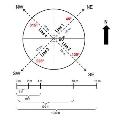
For the evaluation of fuels, in each SU a tree was chosen as the center or reference point and, from this, four 15-m transect lines were marked out, orienting them with a 90º separation pattern and recording the direction or azimuth of each line (Figure 2). Specifically, the planar intersect counting technique was used to estimate the fuel load by counting branches or logs intersecting the vertical plane defined by a transect (Brown, 1971; Sánchez & Zerecero, 1983). The fuel diameter size classes of 0.01-0.60 cm, 0.61-2.50 cm and 2.51-7.50 cm (1, 10 and 100 h timelag, respectively) were chosen by measuring the intersections, while the larger pieces of 7.50 cm (1 000 h timelag) were recorded by their diameters. Four sampling lines (transects) were worked with in order to be able to capture the existing variance and reduce the error, this in case the pieces of downed woody material were not randomly distributed. Accordingly, a total of 96 transect lines were established (48 in the mangroves and 48 in the tropical freshwater forested wetlands).
Quantification of dead fuels
The sampling lines established at each site were sectioned to count fuel intersections on the basis of diameter (Figure 2). The dead fuel material was measured including everything from twigs to logs lying on the ground in the established linear transect (Flores, Xelhuantzi-Carmona, & Chávez-Durán, 2010). Figure 2 shows the distance at which each fuel category was quantified. The woody fuels of 1 h (≤0.60 cm), 10 h (0.61 to 2.50 cm) and 100 h (2.51 to 7.50 cm) were recorded by counting on the basis of the number of intersected pieces using a forest fuel sizing gauge. Fuels of 1 000 h (>7.50 cm in diameter) were measured in the 15 m length of the transect line with the use of a flexometer, separating those found in a sound state from those that had some state of putrefaction.
Data processing
The weight of the woody fuels per diameter class was calculated with the formulas described by Sánchez and Zerecero (1983) indicated in Table 1. The fuel data and calculations were extrapolated to obtain the total amount (t·ha-1). The results were analyzed in a randomized block experimental design, where the stratification criteria were the types of wetlands. The comparison of the mangrove and tropical freshwater forested wetland loads was made through the Student's t-test. On the other hand, the effect within and among the sites of each wetland was analyzed through the corresponding ANOVA (one and two way); subsequently, based on the results, a comparison of means of the variables evaluated was performed with the Tukey-Kramer test. Data analysis was conducted in JMP Pro 12.1 (Statistical Analysis System [SAS], 2015) with a 95 % confidence level.
Table 1 Formulas for calculating the weight of woody fuels (Brown, 1971) adapted by Sánchez and Zerecero (1983).
| Type of fuel | Diameter class (cm) | Formula |
|---|---|---|
| Fine | 0.01-0.60 |
|
| Fine | 0.61 - 2.50 |
|
| Medium | 2.51 - 7.50 |
|
| Coarse | > 7.50 (without rot) |
|
| Coarse | > 7.50 (with rot) |
|
W = fuel weight (t·ha-1), f = frequency or number of intersections, c = terrain slope correction factor, d2 = sum of the squares of the diameters of the branches and logs greater than 7.50 cm, N = number of lines, l = total length of the sampling line or sum of the lengths of the lines (given in linear feet [ft]: 1 m = 3.28 ft, 4 m = 13.12 ft, 10 m = 32.8 ft, 15 m = 49.20 ft).
Results and discussion
Total woody fuel load
The largest amount of combustible woody material corresponds to 1 000 h fuels (>7.50 cm in diameter) with a range of 46.58 to 96.78 t·ha-1 in mangroves and of 32.49 to 101.69 t·ha-1 in tropical freshwater forested wetlands. It is important to mention that, in this category, the largest proportion of woody pieces were found in a state of decomposition or rotting, which indicates that in a short time they will be part of the soil organic layer. Table 2 contains the average values for each category of woody fuels based on their timelag, and the total load per type of vegetation in each of the sites.
Table 2 Total amount of woody fuels by timelag for mangroves and tropical freshwater forested wetlands at three sites in the La Encrucijada Biosphere Reserve. Each site had 16 lines distributed in four sampling units by vegetation type.
| Wetland | Site | Timelag (h) | Total fuel (t·ha-1) | |||
|---|---|---|---|---|---|---|
| 1 | 10 | 100 | 1 000 | |||
| Mangrove | Brisas del Hueyate | 2.85 | 8.08 | 44.67 | 96.78 | 152.39 |
| Mangrove | El Castaño | 3.74 | 9.91 | 32.37 | 78.03 | 124.05 |
| Mangrove | Río Arriba | 5.39 | 13.65 | 23.19 | 46.58 | 88.81 |
| T. F. Forested | Brisas del Hueyate | 2.75 | 7.01 | 18.58 | 34.85 | 63.19 |
| T.F. Forested | El Castaño | 4.16 | 10.06 | 35.96 | 101.69 | 151.87 |
| T.F. Forested | Río Arriba | 4.57 | 10.3 | 33.80 | 32.49 | 81.16 |
T.F. Forested = Tropical freshwater forested wetlands.
Woody fuel load in mangroves and tropical freshwater forested wetlands
Table 3 shows the results of the total woody fuel load by type of vegetation and site in the EBR. According to the results, the Student's t test shows that there is no statistically significant difference between the loads found in mangroves (121.75 ± 44.42 t·ha-1) and tropical freshwater forested wetlands (98.74 ± 55.53 t·ha-1) (F = 1.05; P = 0.31). However, at site level, the Tukey-Kramer test indicates that there is a greater accumulation in El Castaño with 137.96 ± 53.51 t·ha-1 compared to Río Arriba with 84.98 ± 13.37 t·ha-1 (F = 3.29; P = 0.006). The interaction between vegetation type and site was statistically significant (F = 4.48; P = 0.02). According to the two-way ANOVA, the Brisas del Hueyate mangroves (152.39 ± 42.6 t·ha-1) and the El Castaño tropical freshwater forested wetlands (151.87 ± 60.84 t·ha-1) have a greater accumulation of woody fuels compared to the other study areas. The Río Arriba mangroves (88.81 ± 15.84 t·ha-1) and tropical freshwater forested wetlands (81.16 ± 10.5 t·ha-1) show statistically equal loads; on the other hand, the Brisas del Hueyate swamp has the lowest loads (63.19 ± 27.49 t·ha-1).
Table 3 Total woody fuel load of mangroves and tropical freshwater forested wetlands in three sites within the La Encrucijada Biosphere Reserve, Chiapas.
| Factor/level | Mean (t·ha-1) | Statistics |
|---|---|---|
| Wetlands vegetation | ||
| Mangrove | 121.75 ± 44.42 ns | F 1,21 = 1.05 P = 0.31 |
| Tropical freshwater forested | 100.39 ± 55.53 ns | |
| Site | ||
| Brisas del Hueyate | 107.79 ± 58.09 ab | F 2,17 = 3.29 P = 0.006 |
| El Castaño | 137.96 ± 53.51 a | |
| Río Arriba | 84.98 ± 13.37 b | |
| Vegetation*site | ||
| Mangrove, Brisas del Hueyate | 152.39 ± 42.60 a | F 2,17 = 4.48 P = 0.02 |
| Mangrove, El Castaño | 124.05 ± 49.62 ab | |
| Mangrove, Río Arriba | 88.81 ± 15.84 bc | |
| Tropical freshwater forested, Brisas del Hueyate | 63.19 ± 27.49 c | |
| Tropical freshwater forested, El Castaño | 151.87 ± 60.84 a | |
| Tropical freshwater forested, Río Arriba | 81.16 ± 10.50 bc | |
± Standard deviation of the mean. ns = not significant (Student’s t, P < 0.05). Different letters in sites and vegetation*site indicate significant differences (Tukey-Kramer test, P < 0.05).
This indicates that the Brisas del Hueyate mangroves and the El Castaño tropical freshwater forested wetlands are more likely to burn under favorable conditions and elements for fires to spread, due to the greater accumulation of woody fuels. Although the Brisas del Hueyate swamps have the lowest fuel load (63.19 t·ha-1), these quantities are high when compared with studies in some temperate ecosystems (Castañeda, Endara, Villers, & Nava, 2015; Flores & Omi, 2003). In the case of Rio Arriba, the arrival of water currents is less than the other sites due to the soil accumulation caused by meteorological phenomena such as storms and hurricanes. This has led to greater sedimentation, longer droughts and high availability of fuels to catch fire in the event of any human activity related to the use of fire, mainly in the dry season.
The accumulation of combustible material is due to structural elements, expressed through the RIV of the associated species. In the case of mangroves, 10 and 100 h fuels are produced mainly by the old branches and roots of R. mangle. In the case of tropical freshwater forested wetlands, there is a greater production of 1 h fuels formed by the branches of P. aquatica, associated with Cynometra oaxacana Brandegee. The 1 000 h (heavy) fuels originate from the downing of trees due to strong winds and hurricanes, causing vulnerability of the mangrove (Tovilla-Hernández & Romero-Berny, 2012) and tropical freshwater forested wetlands in the presence of fire. All this leads to a greater accumulation of woody fuels that, in the January-May fire season, are available to start ignition.
From the standpoint of necromass production, the shrub and herbaceous elements do not accumulate much material; however, their biomass (mainly of the shrubs) represents an important source of fuel. Specifically, shrubs, herbaceous species and grasses as living fuels favor surface fire spread, which is more marked if the environmental conditions cause dryness of the material. In addition, it should be considered that some shrubs produce highly flammable structures, so their importance lies in their quantity (t·ha-1) and quality (content of flammable elements).
Fuel load per diameter class
Mangroves and tropical freshwater forested wetlands did not show significant differences in average dead fuel loads by diameter class (Figure 3). The average fuel accumulation of the three sites evaluated shows that mangroves and tropical freshwater forested wetlands have similar fuel loads, which may be determined by the same species association.

Figure 3 Comparison of woody fuel load by diameter class between mangroves and tropical freshwater forested wetlands in the La Encrucijada Biosphere Reserve. According to the Student's t test (P > 0.05), there were no significant differences; the standard deviation of the mean is represented on the bars.
Fuel load by diameter classes among sites
At site level, the comparison of fuel loads between mangroves and tropical freshwater forested wetlands, by diameter class, is summarized in Table 4. In the mangroves of the three study sites, the following was found: the fine fuel load (0.01 a 0.60 cm) was significantly different between Brisas del Hueyate and Río Arriba (F = 3.05, P = 0.09); El Castaño had accumulations with characteristics in common with the two areas mentioned; and fine fuel classes of 0.61 to 2.50 cm, medium of 2.51 to 7.50 cm and coarse >7.50 cm (rotten and good) did not show significant differences, as shown in Figure 4. According to the results, the Río Arriba mangroves have greater 1 h fuel loads, due to their high density of mature trees, which generates a fall of leaf litter and twigs, thereby producing large accumulations. On the other hand, in the tropical freshwater forested wetlands of the three sites, the following was found: fine fuels of 0.01 to 0.60 cm and of 0.61 to 2.50 cm, and coarse fuels >7.50 did not show significant differences in average load; however, in the medium class from 2.51 to 7.50 cm there were significant differences between the Brisas del Hueyate load with 18.58 t∙ha-1 (F = 9.93, P = 0.006) and that of El Castaño (35.96 t∙ha-1) and Río Arriba (33.8 t∙ha-1). The latter two show similarity in total average load, as can be seen in Figure 5.
Table 4 Fuel load by diameter class in mangroves and tropical freshwater forested wetlands of three sites in the Encrucijada Biosphere Reserve, Chiapas.
| Sampling units | Mangrove | Tropical freshwater forested | ||
|---|---|---|---|---|
| Average (t∙ha-1) | Statistics | Average (t∙ha-1) | Statistics | |
| 0.01-0.61 cm | ||||
| CG1 Brisas del Hueyate | 2.85 ± 0.45 b | F 2,9 = 3.05 P = 0.04 | 2.75 ± 0.45 ns | F 2,9 =2.75 P = 0.12 |
| CG2 El Castaño | 3.74 ± 1.85 ab | 4.16 ± 1.40 ns | ||
| CG3 Río Arriba | 5.39 ± 1.00 a | 4.57 ± 0.65 ns | ||
| 0.61-2.50 cm | ||||
| CG1 Brisas del Hueyate | 8.08 ± 2.04 ns | F 2,9 = 2.36 P = 0.14 | 7.01 ± 1.65 ns | F 2,9 =2.35 P = 0.15 |
| CG2 El Castaño | 9.91 ± 4.61 ns | 10.06 ± 0.83 ns | ||
| CG3 Río Arriba | 13.65 ± 1.57 ns | 10.30 ± 5.58 ns | ||
| 2.51-7.50 cm | ||||
| CG1 Brisas del Hueyate | 44.67 ± 23.77 ns | F 2,9 = 1.38 P = 0.30 | 18.58 ± 7.22 b | F 2,9 = 9.93 P = 0.006 |
| CG2 El Castaño | 32.37 ± 14.45 ns | 35.96 ± 5.13 a | ||
| CG3 Río Arriba | 23.19 ± 8.38 ns | 33.80 ± 5.35 a | ||
| >7.50 cm rotten | ||||
| CG1 Brisas del Hueyate | 59.67 ± 21.64 ns | F 2,9 = 1.00 P = 0.40 | 20.67 ± 16.22 ns | F 2,9 = 2.60 P = 0.13 |
| CG2 El Castaño | 62.70 ± 40.03 ns | 85.29 ± 64.00 ns | ||
| CG3 Río Arriba | 33.48 ± 6.24 ns | 22.19 ± 5.63 ns | ||
| >7.50 good | ||||
| CG1 Brisas del Hueyate | 37.11 ± 25.97 ns | F 2,9 = 2.57 P = 0.13 | 14.18 ± 9.33 ns | F 2,9 = 0.31 P = 0.73 |
| CG2 El Castaño | 15.33 ± 6.20 ns | 16.40 ± 9.46 ns | ||
| CG3 Río Arriba | 13.10 ± 10.59 ns | 10.30 ± 7.40 ns | ||
± standard deviation of the mean. Different letters indicate significant differences (Tukey-Kramer test, P < 0.05) per diameter class among the Brisas del Hueyate, El Castaño and Río Arriba sites.

Figure 4 Comparison of the woody fuel load by diameter class among mangrove sites in the La Encrucijada Biosphere Reserve. Different letters indicate significant differences (Tukey-Kramer test, P < 0.05). The standard deviation of the mean is represented on the bars.

Figure 5 Comparison of the woody fuel load by diameter class among tropical freshwater forested wetland sites in the La Encrucijada Biosphere Reserve. Different letters indicate significant differences (Tukey-Kramer test, P < 0.05). The standard deviation of the mean is represented on the bars.
The greater amount of 100 h fuels in the swamps of El Castaño and Río Arriba is due to the influence of mature vegetation that generates a constant fall of twigs, mainly when there are strong winds, storms and hurricanes. This accumulated material disintegrates over time, being available in the dry season as a fire spread factor. Ignition originates in the 1 and 10 h fine fuels; the possibility of intensifying the fire and spreading it towards the coarse fuels (1 000 h), which are the most dangerous, is increased through the medium fuel class (100 h). In this context, Villers and López (2004) emphasize that although the amount and proportion may vary, the combination of dead fuel diameter classes is a factor that affects fire spread and intensity, considering that fine fuels (1 h) have greater influence on the distribution.
Loads obtained in temperate forests vary from 0.54 to 3.11 t∙ha-1 for 1 h fuels and from 1.26 to 3.98 t∙ha-1 for 10 h fuels (Castañeda et al., 2015; Chávez et al., 2016; Flores & Omi, 2003), which are lower than those obtained in this study, since the mangroves generated 2.85 to 5.39 t∙ha-1 (1 h) and 8.08 to 13.65 t∙ha-1 (10 h) and the tropical freshwater forested wetlands accumulated 2.75 to 4.57 t∙ha-1 (1 h) and 7.01 to 10.3 t∙ha-1 (10 h). On the other hand, Estrada and Cervantes (2007) determined loads in a temperate climate forest with predominance of Abies in El Chico National Park, Hidalgo, obtaining a total load of 65.85 t·ha-1, considered high for temperate ecosystems. This accumulation is low compared to those of the present study, which range from 88.81 to 152.39 t∙ha-1 for mangroves and from 63.19 to 151.87 t∙ha-1 for swamps. In short, this shows that mangroves and tropical freshwater forested wetlands can accumulate 50 % more fuel than temperate forests.
Within the studies oriented to average carbon stocks, carried out in the EBR, Adame et al. (2015) found downed woody material loads ranging from 11 to 205 t∙ha-1 with an average biomass of 26 to 59.4 t∙ha-1. This value is low compared to the range obtained in the mangroves and swamps. In another study conducted in tropical freshwater forested wetlands in Yucatán, Reyes and Coli (2009) reported fuel loads equivalent to 16.46 t∙ha-1, which are low compared to those obtained in the present study; however, the largest amount corresponds to fine fuels (7.45 t∙ha-1) that constitute significant accumulations, even greater than those obtained in the tropical freshwater forested wetlands evaluated in this work. On the other hand, in the tropical forests of Calakmul in Campeche, Neri-Pérez, Rodríguez-Trejo, and Contreras-Aguado (2009) reported total loads of 43.15 to 154.5 t∙ha-1, which are within the range obtained in the tropical freshwater forested wetlands of the EBR. In general, however, there are few studies that allow comparing the amount of dead fuels in wetlands, and that are aimed at establishing relationships with the presence of fires. It is hoped that the present research will contribute to the state of the art of evaluating dead fuel loads in wetlands and, most importantly, serve as a basis for subsequent studies aimed at fire management in the reserve.
The study of woody fuels classified by size is necessary to understand the dangerousness of the fuel element and fire behavior in forest ecosystems (Villers & López, 2004). The Rio Arriba site has a significant fine fuel load (0.01 to 0.60 cm) in its mangroves, which would give rise to a surface fire and one with greater displacement. This is different in the swamps of Brisas del Hueyate and El Castaño, where there are larger accumulations of medium-sized fuels (2.51 to 7.50 cm), which when burned and associated with coarse fuels can generate fires of greater magnitude and intensity.
Although there are variations in the woody fuel load among sites, we accepted the hypothesis that there are no significant differences in fuel accumulation between mangroves and tropical freshwater forested wetlands, because both systems have common characteristics, are structurally arboreal and share some species (Adame et al., 2015; Infante-Mata, Moreno-Casasola, & Madero-Vega, 2014). Table 5 summarizes the composition and structure at the level of vegetation and sites evaluated. Relative frequency and the RIV demonstrate the association of four species in common: P. aquatica, R. mangle, Inga laurina (Sw.) Willd. and C. oaxacana in mangroves and tropical freshwater forested wetlands. Only the El Castaño mangrove, dominated extensively by R. mangle (RIV = 293.7), shows the absence of these species, which determines an intermediate woody fuel load in this study area.
Table 5 Relative frequency (RF) and relative importance value (VIR), structural parameters of density and basal area that show the similarity in the association of arboreal species between mangroves and tropical freshwater forested wetlands in the three study sites within the La Encrucijada Biosphere Reserve.
| Species | Brisas del Hueyate | El Castaño | Río Arriba | |||||||||
|---|---|---|---|---|---|---|---|---|---|---|---|---|
| Mangrove | Tropical freshwater forested | Mangrove | Tropical freshwater forested | Mangrove | Tropical freshwater forested | |||||||
| RF | RIV | RF | RIV | RF | RIV | RF | RIV | RF | RIV | RF | RIV | |
| Pachira aquatica | 87.13 | 226.34 | 94.10 | 285.28 | - | - | 89.58 | 258.75 | 79.80 | 190.46 | 89.64 | 275.84 |
| Rhizophora mangle | 9.20 | 64.47 | 0.67 | 3.08 | 96.94 | 293.70 | 0.54 | 17.76 | 8.00 | 81.42 | - | - |
| Cynometra oaxacana | 2.76 | 5.93 | 0.34 | 0.70 | - | - | 9.07 | 21.46 | - | - | - | - |
| Inga laurina | 0.46 | 1.97 | 2.70 | 5.72 | - | - | 0.68 | 1.53 | 12.20 | 28.13 | 9.67 | 22.28 |
| Laguncularia racemosa | - | - | - | - | 3.06 | 6.30 | - | - | - | - | - | - |
| Anonna glabra | 0.46 | 1.30 | 0.67 | 2.03 | - | - | - | - | - | - | - | - |
| Coccoloba barbadensis | - | - | - | - | - | - | - | - | - | - | 0.67 | 1.88 |
| Lianas: Dalbergia ecastaphyllum, Vitis caribaea | - | - | 1.52 | 3.19 | - | - | - | - | - | - | - | - |
| Total | 100 | 300 | 100 | 300 | 100 | 300 | 100 | 300 | 100 | 300 | 100 | 300 |
| Density (ind∙ha-1) | 1 740 | 2 965 | 490 | 3 695 | 2 500 | 2 945 | ||||||
| Basal area (m2∙ha-1) | 54.62 | 68.54 | 28.13 | 57.14 | 42.95 | 38.48 | ||||||
Relative frequency and the RIV provide a certain degree of knowledge about the species that give rise to the woody fuels on the ground. In order of importance, the mangroves are mainly home to R. mangle, P. aquatica, C. oaxacana, I. laurina, L. racemosa and Anonna glabra L., while the tropical freshwater forested wetlands mainly have P. aquatica, R. mangle, C. oaxacana, I. laurina, L. racemosa, A. glabra, Coccoloba barbadensis Jacq. and lianas such as Dalbergia ecastaphyllum (L.) Taub. and Vitis caribaea DC.
It is clear that the two ecosystems (mangroves and tropical freshwater forested wetlands) have the same potential to catch fire as they do not show significant differences in their woody fuel load, which is considered a favorable element for ignition. Although only a few studies have focused on temperate ecosystems in Mexico, in general, the decomposition time of combustible material can be considered as follows: organic matter (1 to 2 years), leaf litter (3 to 5 years), fine woody material (8 to 10 years) and coarse woody material (20 to 60 years). This will be strongly conditioned by environmental factors, especially temperature and humidity, as well as contents and concentrations of chemical components (lignins, cellulose and hemicellulose) and wood density. According to this, a more accelerated fuel decomposition rate would be expected in tropical ecosystems, mainly due to high humidity and temperature; however, in the specific case of mangroves, the high relative density of their wood and the tannin content imply a slower decomposition rate. This indicates that studies must be carried out that not only determine the decomposition rates of combustible material in different ecosystems and conditions, but also evaluate the rate of recovery of the material. This will assist in the determination of the cycle of fuel load dynamics and, in turn, the reduction of uncertainty in aspects such as the fire regime (frequency, intensity, behavior and impact).
On the other hand, it is advisable to implement fuel management actions fomented by an integrated fire management plan, which includes physical prevention activities. These may include the establishment of firebreaks, green fuel barriers to stop fire, firewood extraction, transfer of combustible material, pruning and removal of low branches with horizontal continuity. Finally, because fire originates in the herbaceous wetlands - tular and popal areas- of the reserve, prescribed fires in those areas adjacent to the mangroves (Hogarth, 2007; Tovilla-Hernández & Romero-Berny, 2012) and tropical freshwater forested wetlands would be a viable alternative to reduce the accumulation of these herbaceous fuels.
Conclusions
Quantification of forest fuels is possible in coastal wetlands, such as mangroves and tropical freshwater forested wetlands, finding loads up to three times higher than those in other temperate ecosystems. The mangroves and tropical freshwater forested wetlands of the La Encrucijada Biosphere Reserve share some dominant tree species such as R. mangle and P. aquatica, which is reflected in the similarity of the loads obtained in both types of arboreal wetlands. The results obtained provide guidelines for subsequent studies and can favor decision-making for the prevention of fires in the reserve’s wetlands, supporting the prioritization of zones vulnerable to forest fires.

