


 texto en
  Inglés (pdf)
 Artículo en XML
 Referencias del artículo
 Enviar artículo por email
 Citado por SciELO
  Similares en
SciELO
Similares en
SciELO 
 Permalink
Introduction
The importance of soils for sustaining human life has been recognized during the last half century by both national (Secretaría de Medio Ambiente y Recursos Naturales [SEMARNAT], 2002) and international organizations (Food and Agriculture Organization of the United Nations [FAO], 1999, 2006, 2009). One of the strategies for protecting soil from degradation is by evaluating its environmental functions (Banwart et al., 2012; Bouma, 2009; Lehmann, 2006; Lehmann, David, & Stahr, 2008), which must be quantitatively defined through replicable procedures. Likewise, it is important to analyze these functions in terms of relative importance, which makes it possible to establish the particular level of capital and services in a specific social context, where the ultimate goal is to provide well-being to human beings and the environment (Bautista, Gallegos, & Álvarez, 2015; Blum, 2005; Lehmann et al., 2008).
Through different action plans or strategies, various authors have recognized and evaluated the following environmental, economic, social and cultural soil functions: filtration and regulation of heavy metals, as a component of the water cycle, food and biomass production, as a component of the nutrient cycle, habitat for flora, fauna and human life, transformation medium, natural and cultural archive, filtration and infiltration, and organic carbon fixation (Bautista et al., 2015; Bouma, 2009; Brady & Weil, 1999; Lehmann et al., 2008).
Lehmann et al. (2008) and Lehmann and Stahr (2010) developed models and software for evaluating soil functions based on data from soil profiles (TUSEC); however, the software is impractical and of limited use. Bautista, Gallegos, and Pacheco (2016) reviewed these evaluation models and designed a more functional software called Soil & Environment® that operates in two directions, as a database for recording information on soil profiles and for evaluating their functions, quantitatively, through interpretative models.
Knowledge of soil properties and characteristics is of great importance; appropriate crop selection and practices suitable for soil conservation depend on having this knowledge, thereby ensuring continuous soil use with minimum loss of quality. Much of this information is held by farmers, who have accumulated extensive knowledge about their natural environment over generations. In this way, based on the knowledge of farmers, suitable strategies can be designed and developed to achieve sustainable production systems. The use of smallholder farmer land classes is very useful as a means of communication at the local level (Bautista & Zinck, 2010) and of technology transfer (Nethononda & Odhiambo, 2011; Segura-Castruita et al., 2011).
The Zicuirán-Infiernillo Biosphere Reserve (ZIBR) has great geodiversity, expressed in geoforms, climatic types and subtypes, and soil groups. However, it is marked by land-use conflicts and threats, due to the migration of the rural population into the interior of the reserve to occupy new lands. Population growth and immigration cause conflicts that affect different aspects; on the one hand, the preservation of the environment, the protection of landscapes and the conservation of biodiversity and geodiversity and, on the other, the satisfaction of the basic needs of the population in this area. Therefore, it is necessary to offer alternatives to ensure the conservation and protection of the biodiversity, as well as the social and economic development of the community. The objective of this study is to evaluate the environmental functions of the soils in the Zicuirán-Infiernillo Biosphere Reserve (ZIBR), using the land classes identified by peasants.
Materials and methods
The study site comprises two zones belonging to the ZIBR, one a buffer area and the other an area of influence. The site is located in the municipality of La Huacana, Michoacán, Mexico, between coordinates 19° 0’ 0” and 18° 52’ 0’’ NL and 101° 56’ 0” and 101° 42’ 0” EL (Figure 1), with elevation levels ranging from 200 to 800 m. The climate is warm subhumid (Aw0) with rain during the summer; the average annual rainfall is 655 mm and the average annual temperature is 28 °C (Comisión Nacional del Agua [CONAGUA], 2000).

Technicians and producers jointly described 35 soil profiles of 1.5 m in depth or as far as the parent material allowed. The profiles corresponded to seven land classes: Barrosa, Polvilla, Charanda, Tocura, Cementante, Polvilla/Barrosa and Polvilla/Charanda. The main characteristics of the physical environment and the morphology of the soil profile were recorded based on the criteria established by Siebe, Janh, and Stahr (2006) and FAO (2009). The physical and chemical analyses carried out were bulk density, texture, wet and dry color, pH, organic matter, exchangeable cations (Ca, Mg, Na, K) and electrical conductivity (SEMARNAT, 2002).
Using the Soil & Environment® software, information on soil profiles was evaluated for the following environmental functions: the water cycle component, food and biomass production, nutrient cycle component, habitat for flora and fauna, habitat for human life and torrential rainfall filtration (Bautista et al., 2015; Gallegos, Bautista, & Dubrovin, 2016). The evaluations were interpreted based on five classes representing the capacity of soil functions: very high (5), high (4), medium (3), low (2) and very low (1).
A geopedological map was made that has the geoforms as a cartographic base and the land class associations as a legend (Zinck, Metternicht, Bocco, & Del Valle, 2016). The map, developed in ArcGIS 9.3.1 (Environmental Systems Research Institute [ESRI], 2009, WGS 1984 datum, Universal Transverse of Mercator [UTM] projection), was used for mapping the environmental functions of the land classes.
Results and discussion
Environmental functions of the land classes
The physical and chemical properties of the soils by horizon (Figure 2) were transformed into measurements of the properties by profile (Table 1), which allowed a better understanding of the functioning of the soil in an integrated manner, enabling the evaluation of its environmental functions.
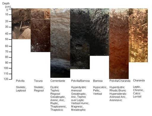
Figure 2 Profiles of the smallholder farmer land classes identified and classified according to farmer knowledge and IUSS Working Group WRB (2006) for soils of the Zicuirán-Infiernillo Biosphere Reserve, Mexico.
Table 1 Properties of the soils by full profile in the Zicuirán-Infiernillo Biosphere Reserve, Mexico.
| Profile key | Land Use | Depth (cm) | FE (kg·m-2) | FC (L·m-2) | CEC (mol·m-2) | SOC (t·ha-1) | pH | OM |
|---|---|---|---|---|---|---|---|---|
| Polvilla/Cobano-001 | IG and SV | 29 | 150.8 | 35.58 | 40.48 | 16.12 | 7.6 | 1.3 |
| Barrosa/P7 | ENCR and LDF | 50 | 554.71 | 229.91 | 241.23 | 156.14 | 7.2 | 4.3 |
| Cementante/0013 | RA, LDF and MF | 135 | 1 675.5 | 305.81 | 163.48 | 108.05 | 7.6 | 1.1 |
| Polvilla-Barrosa/P20 | C | 110 | 1 099.8 | 297.9 | 241.56 | 95.87 | 7.5 | 1.5 |
| Polvilla-Charanda /0028 | SV and EG | 124 | 710.72 | 165.8 | 37.58 | 73.89 | 5.1 | 2.1 |
| Charanda/0033 | RA, EG and SL | 96 | 663.6 | 214.18 | 152.15 | 88.38 | 7.4 | 2.4 |
| Tocura/0037 | C and LDF | 110 | 1 344.9 | 334.97 | 204.18 | 210.59 | 8.3 | 2.4 |
FE = fine earth, FC = field capacity, CEC = cation exchange capacity, SOC = soil organic carbon, OM = organic matter. Land uses: IG = intensive grazing, ENCR = extensive nomadic cattle ranching, LDF = low deciduous forest, MF = medium forest, C = crops, RA = rainfed agriculture, EG = extensive grazing, SL = selective logging, SV = secondary vegetation.
According to Table 2, the Barrosa land class, distributed in the valley, has the most suitable environmental levels, followed by the Polvilla-Barrosa class with very high capacity in terms of torrential rainfall infiltration and the Tocura and Polvilla-Charanda classes with high suitability in the same environmental function. Next is the Charanda class, suitable for food and biomass production and as a nutrient cycle component; finally, with more restricted suitability, in general terms, there is the Polvilla class that stands out as a habitat for flora and fauna.
The habitat for flora and fauna is a measure of the "naturalness" of the site because the degree of disturbance is evaluated. In this sense, the Polvilla/Barrosa class exhibits favorable conditions as habitat for flora and fauna; it is also suitable as a water cycle component and for aquifer recharge. This land class is located in the altiplano; therefore, the most suitable function is as a conservation area. However, it is also reported as suitable for human life, a situation that would conflict with the environmental functions.
Table 2 Evaluation of the environmental functions of the soil profiles in the Zicuirán-Infiernillo Biosphere Reserve, Mexico.
| Land classes | FB | NC | WC | FFH | TRI | HHL | Suitability | Suggested use |
|---|---|---|---|---|---|---|---|---|
| Tocura (foothills) | 2 | 2 | 4 | 3 | 4 | 1 | 16 | Conservation |
| Barrosa (valley) | 5 | 5 | 3 | 2 | 2 | 1 | 18 | Agriculture |
| Polvilla/Barrosa (altiplano) | 2 | 1 | 3 | 3 | 5 | 3 | 17 | Conservation |
| Polvilla (hill) | 1 | 2 | 1 | 5 | 1 | 1 | 11 | Conservation |
| Cementante (plain) | 3 | 3 | 3 | 1 | 4 | 1 | 15 | Urbanism |
| Charanda (plain) | 4 | 4 | 3 | 2 | 2 | 1 | 16 | Agriculture |
| Polvilla/Charanda (plain) | 2 | 2 | 3 | 3 | 5 | 1 | 16 | Urbanism |
FB = food and biomass, NC = nutrient cycle, WC = water cycle, FFH = flora and fauna habitat, TRI = torrential rainfall infiltration, HHL = habitat for human life. Suitability classes: very high (5), high (4), medium (3), low (2) and very low (1).
The environmental functions of the land classes and their current uses
The Polvilla/Charanda, Cementante and Charanda land classes are located in the plains (Table 2). The Polvilla/Charanda class with secondary vegetation is used for extensive semi-nomadic grazing; based on the evaluations, the ideal function is torrential rainfall infiltration. The Cementante class is used mainly in rainfed agriculture and is suggested as a rainfall infiltrator, food and biomass producer, and nutrient cycle component, while Charanda, with rainfed agriculture, extensive nomadic grazing and selective logging, presents qualities as a nutrient cycle component and for food and biomass production.
In the valley, the Barrosa class is located in low deciduous forest with extensive nomadic cattle ranching. This type of land has the suitability to be used as a means of producing food and biomass or as a nutrient cycle component; it is not desirable for it to be used as habitat for human life because it would undermine the food supply and affect the water quality of the rivers, as is already seen today.
The Polvilla/Barrosa class dominates the high plateau and is currently used for the cultivation of pastures; this land use could be compatible with the infiltration capacity in torrential rains; on the plain, this class is suitable as habitat for human life.
In the hill areas, the Polvilla class is reported to have secondary vegetation and to be used for intensive cattle grazing. Based on the evaluation of soil functions, it is suggested that this type of land be used as a habitat for flora and fauna.
Finally, the Tocura land class, located in the foothills and used for pasture cultivation, could be used as a torrential rainfall infiltrator or as a water cycle component.
Land evaluation is "the process of assessment of land performance when used for specific purposes" (FAO, 1999), although it can also be "all the methods to explain or predict land-use potential" (De la Rosa, Mayol, Díaz-Pereira, Fernández, & De la Rosa, 2004.) A land assessment should consider the following factors: climate, soil, relief, market, technological level to apply and current land use. For each factor, an interpretative method and the assignment of ranges (suitable, moderately suitable, marginally suitable and unsuitable) are needed. In this sense, an analysis of the soil profile in relation to its environmental functions, carried out in a systematic and orderly way by means of software, is a contribution to the process of assessing its capacities.
Assessing the environmental functions of soils through Soil & Environment® adds to the diversity of interpretive soil models (FAO, 1999, 2009; Segura-Castruita, Sánchez-Guzmán, Ortiz-Solorio, & Gutiérrez-Castorena, 2005; United States Department of Agriculture [USDA], 2014). According to Bautista et al. (2016), the automation of interpretive soil methods using specialized software provides the following advantages: a) reduces errors in the capture of base information, b) avoids potential data loss, c) decreases data query time, d) avoids introducing errors in the application of evaluation techniques and e) improves the handling of information emanating from the evaluation.
The soil function map (Figure 3) represents a model of integration and interaction of some of the soil-forming factors. This proposed land-use model must be discussed among authorities, technicians and the productive and environmental sector.
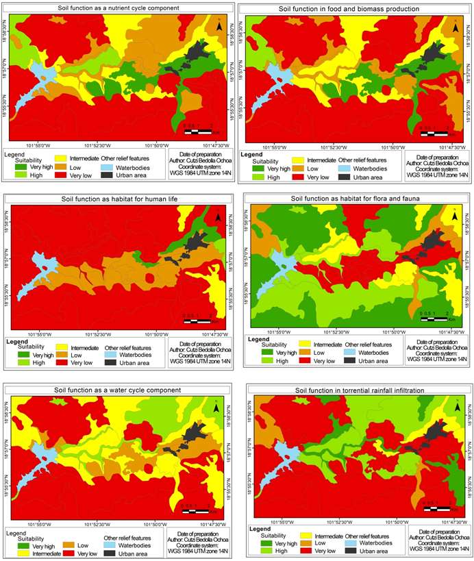
Figure 3 Suitability of soil classes based on environmental functions, using Soil & Environment®, in soils of the Zicuirán-Infiernillo Biosphere Reserve, Mexico.
This study represents the first contribution in terms of evaluating soil functions carried out in Mexico. Similar to the conclusion formed by Liang, Lehmann, Wu, and Stahr (2014), evaluations aimed at an appropriate use of natural resources allow for a global understanding of the soil and provide references for the planning of its use.
Conclusions
In the Zicuirán-Infiernillo Biosphere Reserve, the Barrosa and Charanda land classes have the greatest potential in terms of their function as food and biomass producers, and as a component of the nutrient cycle. However, these classes correspond to the area with the largest human settlements; that is, they are located in fertile, flat, deep and more moist soils, a situation that could cause problems in the supply of agricultural and livestock products. Therefore, there is a need to form an effective evaluation and conservation mechanism to balance land uses, considering their best environmental suitabilities and functions. On the other hand, Soil & Environment® uses information on the climate and slope of the terrain or geoform for the estimation of some models; for this reason, the software requires the incorporation of climate and relief databases, as well as of the uses of the land and its proximity to roads and waterbodies.

