


 texto en
  Inglés (pdf)
 Artículo en XML
 Referencias del artículo
 Enviar artículo por email
 Citado por SciELO
  Similares en
SciELO
Similares en
SciELO 
 Permalink
Introduction
Subsidies granted to forest plantations in Chile have increased since 1974 with the enactment of Decree Law 701, which was aimed at developing high-yield plantations covering between 75 and 90 % of the costs of planting. Initially, the main beneficiaries were large landowners; later in 1998, Decree Law 19.561 reformulated the subsidy system so that small landowners could obtain the benefits and strengthen to some extent soil conservation. Due to the lack of availability of large tracts of land and an increase in their commercial value, forest farms were created by encouraging the occupation of marginal farmland with forest plantations. Thus, in 2004, smallholders had more than 40,000 hectares planted and were organized to take advantage of economies of scale during the planting, maintenance and harvesting processes (Organización de Cooperación y Desarrollo Económico [OCDE] & Comisión Económica para América Latina y el Caribe [CEPAL], 2005).
Forest product exports rank third with 13 %, after mining and the food industry with its derivatives, making up 3.5 % of gross domestic product (Donoso & Otero, 2005). Pulp accounts for 47.5 % of forest exports, followed by lumber with 43.1 % and paper and paperboard with 9.4 % (Banco Central de Chile, 2015; OCDE & CEPAL, 2005). Demand for forest products has led to an increase in exotic pine and eucalyptus plantations, and forest plantations in Chile have grown at an annual rate of 2.17 % in the last 14 years (Corporación Nacional Forestal [CONAF], 2011). These plantations occupied 2,119,005 ha in 1997, representing 13.55 % of the forest cover; in 2011, the area increased to 2,872.007 ha, representing 17.22 % of the forest cover (CONAF, 2011).
The main market for forest plantation products is the pulp and paper industry. This industry is found from the Maule Region to the Los Ríos Region with a total of nine active mills with a production capacity of 6 million tons per year. The Maule Region is characterized by having the highest concentration of forestry activity with the presence of pulp industries. On the other hand, the Los Ríos Region, declared a tourist area and characterized by its richness in native forest and biodiversity, has not been left out of the process of pulp mill construction. In 1995 construction began on the Valdivia plant in Mariquina county, located 10 km from the city center. The plant started in 2004 with a capacity of 550,000 t∙year-1 of bleached Kraft pulp, derived from radiata pine and eucalyptus, demanding large tracts of forest plantations as raw material (Comisión Regional del Medio Ambiente de la Región de los Lagos, 1998).
The temperate rainforest area of southern Chile is the only example of a temperate forest biome in South America, making it one of the most important biodiversity sites worldwide due to the endemism of its species (Armesto, Rozzi, Smith-Ramirez, & Arroyo, 1998; Smith-Ramírez, 2004). Other important factors involving these forests are related to the provision of ecosystem services such as water production and quality, temperature regulation, soil protection, oxygen production, CO2 sinks and landscape beauty.
According to Donoso and Otero (2005), Chile is still faced with the task of improving levels of environmental sustainability due to the lack of a strong institutional framework that ensures good management of industrial plantations and native forests, thereby safeguarding biodiversity, productivity and domestic services. This research describes pine and eucalypt forest plantation land use in an area of southern Chile where a pulp mill has been operating since 2005. The objectives were to: a) perform a spatial analysis to test the hypothesis that polygons that fragment land use with forest plantations are not spatially related, which would explain why the forest industry undertakes land-use conversions without following the existing use pattern and why private owners perform this action in isolation; b) construct local indicators to determine the relevance of plantation polygons with similarities in their environment; c) explain the effect of plantations on the dynamics of land-use change, which would prove the pressure to which the different land uses, especially the native forests, have been subjected as a result of the replacement of native by exotic species by forest plantations.
Materials and methods
Study are
The study area was Mariquina county (known in Chile as a comuna, being the country’s smallest administrative unit), located in the Los Ríos Region in southern Chile (Figure 1). The county is located between 39° 31” 0’ SL and 72° 58” 0’ WL, at an average height of 1,430 m; it is bordered to the North by the Lanco and Loncoche counties, to the South by the Valdivia county, to the West by the Pacific Ocean and to the East by the Máfil county. Mariquina county has a population of 19,823 in an area of 132,100 ha (Instituto Nacional de Estadísticas [INE], 2002). The area is characterized by three physiographic units represented by the Andes mountain range, the Intermediate Depression and the Chilean Coastal Range (in Spanish, the Cordillera de la Costa), which runs from north to south. The climate is rainy with Mediterranean influence and annual temperatures range between 9 and 10 ºC on the coast and the coastal range areas. The area is characterized by a West-East precipitation gradient that on average ranges between 1,200 and 1,600 mm annually, being concentrated mainly between March to August, with a drier period between January and February, when precipitation does not exceed 60 mm.

Figure 1 Location of Mariquina county (study area). On the left is the location of the Los Ríos Region in southern Chile and on the right the county under study.
The native temperate rainforests are characterized by the presence of endemic arboreal species with dominance of species classified as evergreen; their greatest presence is transversal between the Andean summit and the Coastal range. There are also mixed forests composed of native and exotic species. The environmental conditions of the territory have allowed for the proliferation of forest plantations, based on fast-growing exotic species such as eucalyptus and pine. In the Intermediate Depression there is an important area (45 %) consisting of grasslands and shrublands (CONAF et al., 1999).
Databases
Data were obtained from a broader project that consisted of updating the land-use cover of the Los Ríos Region in the period 2006-2013. High-resolution images available on Google Earth (http://earth.google.com) were used; in the georeferencing, control points obtained from the vectorial covers from the cadastre and national land-use monitoring (CONAF, 2008) were used. The polygons with the classification of uses were digitized on the georeferenced images of the year 2013, assigning a unique identification number to each new polygon, in addition to the cover number of the previous period.
The typology for the classification of land-use/cover was based on the methodology developed by the Louis Emberger Center for Phytosociological and Ecological Studies (CEPE/CNRS of Montpellier, France), known as the Land Occupancy Chart (Etienne & Prado, 1982). This chart was adapted and validated in Chile, extending it to 44 subcategories in the cadaster and evaluation of Chile’s native vegetation resources (CONAF et al., 1999). The main types of use are: urban and industrial areas, agricultural land, grasslands and shrublands, forest plantations, native forest, mixed forest, wetlands, and areas devoid of vegetation, snow, glaciers and water bodies.
Field visits allowed ratifying the cartographic classification of the polygons and describing them with land-use changes. Forms were used to describe each polygon in relation to current use, causes of change and presence of species (Sandoval, 2008). The forms were inputted into an information system built for monitoring and updating land-use change (Vergara & Sandoval, 2010). The field information was validated and later joined to the graphical database through the unique polygonal identifier, using ArcMap 10.1 software (Environmental Systems Research Institute [ESRI], 201s were crossed and a cover with administrative limits was also included, obtaining an alphanumeric and graphical base with the current land use in the Los Ríos Region. A polygon cover in shape file format was also generated for the study area. The data in each polygon with the forest plantation area were used to measure spatial autocorrelation through Moran’s index, using GeoDa software (Anselin, 2003). The neighborhood between plantation polygons was defined in the first-order contiguity by the queen-type criterion; that is, if any part of the borders or vertices that make up the irregular plantation polygons are touched, then they are considered neighbors.
Spatial analysis
The global Moran area autocorrelation coefficient (I) (Moran, 1950) is similar to the correlation coefficient proposed by Pearson (1896), but includes the spatial concept, indicating the covariance between different areas in the numerator, variance in the denominator and a matrix with distance or contiguity weights defining the neighboring areas. The index varies between -1 and 1, where values close to 0 indicate a lack of spatial relationship or presence of a random pattern, which would prove our hypothesis; other values indicate the presence of autocorrelation. Negative values indicate a spatial conglomerate of territorial units with different analysis values, and positive values indicate a spatial conglomerate of territorial units with similar analysis values, whether high or low. The global Moran’s index (I) was obtained from:
where:
n |
Case number |
x i |
Value of the variable in a given place |
x j |
Value of the variable in another place (i ≠ j) |
𝑥 |
Mean of the analysis variable |
w ij (d) |
Weight applied to the comparison between the distance of location i and the location j, determined by d |
The value of w ij (d) is equal to 1 if the location j is within the location distance measured from point i, while w ij (d) is equal to 0 if the above assumption is not satisfied. The matrix of spatial weights {w ij (d)} has a diagonal that is worth 0 and the elements outside of it are worth 0 or 1, depending on whether it is inside or outside the distance d (Anselin, 2003).
The global Moran index represents a statistical summary, indicating the intensity of autocorrelation between territorial groups, but does not identify the pattern of spatial relationships. The local Moran index (Ii), local index of spatial association index (LISA), was calculated to know the relevance of similar values with respect to their environment. In order to characterize the spatial configuration of the plantations, the index that allows evaluating the degree of grouping of similar and dissimilar observations is defined as:
This index allows identifying polygons in the territory where the analysis values (area of high or low value plantations [ha]) are grouped spatially, as well as polygons with plantation area very different from those of the surrounding areas (Anselin, 1995).
Temporal analysis
Land-use changes in the period 2006-2013 were quantified with a double-entry transition matrix, where the rows and columns represent the land-use types for both periods; each cell, the area of the zones that presented changes in the period, and the diagonal is left represented by the area of the use types that did not present changes (Aguayo, Pauchard, Azocar, & Parra, 2009). The matrix was constructed with an information system developed in the geomatics laboratory at the Universidad Austral de Chile (Vergara & Sandoval, 2010). The rate of change in the period was calculated using the formula proposed by Puyravaud (2003):
P = Annual rate of change (%)
A1 = Area of the use class at the initial time (ha)
A2 = Area of the use class at the final time (ha)
t1 = Year of initial evaluation
t2 = Year of final evaluation
Results and discussion
Results show that the forest plantations are spread throughout the whole territory, with emphasis towards the northern sector (Lanco and Loncoche counties) and the east sector with the boundary of Máfil county, where the best road network is found and the pulp mill is located nearby. Plantations near wetlands were observed, and in some cases they are demarcated without separation corridors; there is a herringbone-shaped penetration into the native forest, causing degradation, where forest use remains as such, but it loses density in its crown cover (e.g. from native forest it went to arborescent shrubland and to mixed forest), and is also fragmented with different-sized polygons (Figure 2). Nahuelhual, Carmona, Lara, Echeverría, and González (2012) conducted a study in south-central Chile to assess the vulnerability of native forests in unprotected areas prone to conversion to forest plantations. The authors determined that the forest plantations do not have a distribution pattern, but expand in different directions, establishing themselves in the secondary native forest, further generating biodiversity loss. Coinciding with the results of this research, Wilson, Newton, Echeverría, Weston, and Burgman (2005) determined that climate, topography, soil and proximity to roads, cities and industrial areas are relevant spatial distribution factors in the likelihood of conversion.
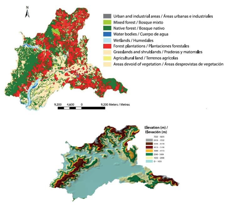
Figure 3 shows that the global Moran index for forest plantations is 0.06 (P < 0.01), indicating the presence of a random pattern throughout the whole territory with the existence of many isolated polygons of various sizes and without neighbors. Van Holt, Binford, Portier, and Vergara (2016) analyzed a wide area encompassing two regions in southern Chile and verified that plantations were established in foothills of predominantly agricultural watersheds rather than in watersheds dominated by native forests or in flat, agriculturally productive areas.
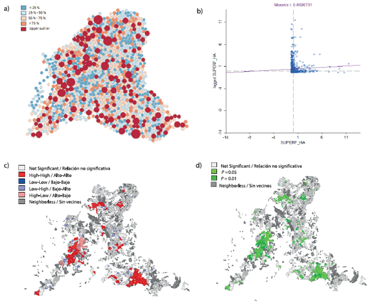
Figure 3 a) Territorial fragmentation and size of forest plantation polygons in Mariquina county, Chile, b) global Moran index for the variable plantation polygon, c) Conglomerate map of plantation polygons, d) Significance map of plantation polygons.
The random distribution of exotic species by natural regeneration also occurred in the Chilean Patagonia, where exotic plantations were initially established to control erosion caused by fires and livestock. Later, these plantations were introduced for commercial purposes, and because of the ease of adaptation to local conditions, a natural regeneration occurred that invaded native forests and generated different spatial patterns (Langdon, Pauchard, & Aguayo, 2010). A similar situation was reported in the Argentinian Patagonia, where exotic species with productive purposes such as the lodgepole pine showed an invasive expansion on the steppe, and the Douglas fir on cypress forests (Sarasola, Rusch, Schllichter, & Ghersa, 2006).
As the global Moran index is only a statistical summary indicating the intensity of autocorrelation between territorial groups, it is necessary to identify some spatial relationship patterns. For this reason, the local Moran index was constructed to identify territorial units (plantation polygons) that are grouped together. High (large polygons) or low (small polygons) analysis values are grouped spatially, as well as polygons with values very different from the surrounding areas. Thus, in our study we can distinguish the following types of spatial conglomerates
High-High. Plantation polygons with above-average area, significantly surrounded by neighboring polygons that also have an above-average area, correspond to forest company areas that occupy large tracts of land with forest plantations in the county (Figure 3). Some conglomerates of this type also appear, extending towards the limits of Máfil county in an easterly direction and Valdivia county towards the South. Altamirano and Lara (2010) studied the Andean foothills of south-central Chile and determined that 63 % of forest plantations were found in covers corresponding to native forest, areas with intermediate elevation levels and a short distance from the road network. González, Lara, Urrutia, and Bosnich (2011) warn that the extensive areas of forest plantations and ecosystems highly fragmented and invaded by exotic species, together with the decrease in precipitation and the increase in recurrent droughts, generate a high continuity of fuel prone to forest fires.
Low-High. It refers to plantation polygons with a small area, significantly surrounded by neighboring polygons with a larger than average area (Figure 3). This situation occurs when smallholders, neighbors to the forest plantations, are left surrounded by forestry companies and decide to devote their lands to the forestry activity, as a result of the previous degradation of native forest by the extraction of firewood. The study by Aguayo et al. (2009), in south-central Chile, explains the transformation of native forest into shrublands and, later, a large percentage of the latter is converted into forest plantations. Other research attributes a large percentage of the replacement of native forest to forest plantations directly (Lara, Solari, Prieto, & Peña, 2012; Nahuelhual et al., 2012).
High-Low. It refers to the presence of polygons with large-scale plantations, significantly surrounded by polygons of neighboring plantations with below-average area; that is, smallholders who neighbor large plantation owners and decide to devote their property to forest use.
Neighborless. When considering in the analysis only the polygons with forest plantations, a territorial fragmentation with many different-sized, neighborless polygons is produced. This is confirmed by the global Moran index, which indicates a random plantation pattern; it also coincides with the study of Nahuelhual et al. (2012), who mention the proliferation of a number of polygons fragmented into different sizes and distributed throughout the landscape.
Not significant. It is produced by the presence of plantation polygons, where the variable polygon area is not significantly related to the values presented by their neighbors. This is due to fragmentation and the presence of other uses as neighbors.
Spatial analysis using Moran’s index is a technique not widely used in the field of natural resources; however, its use in research related to spatial analysis of forest fires (Ávila-Flores, Pompa-García, & Vargas-Pérez, 2010; Pompa-García, & Hernández-González, 2012) and changes in plant cover (Rodríguez, Pompa-García, Hernández-Díaz, & Juárez-Reyes, 2010) should be highlighted. The change matrix reveals that the land-use covers that presented the greatest transformations were the urban and industrial areas, forest plantations, agricultural land and grasslands-shrublands, dynamics coinciding with that found by Aguayo et al. (2009). Urban and industrial areas grew at an annual rate of 12.5 %, followed by forest plantations at 2.7 % (Table 1), which is in line with official figures published by CONAF (2011). The grassland-shrubland cover had a negative annual rate (-1.7 %) (Table 1), with its greatest loss in area (4,412 ha) resulting from the establishment of forest plantations (Table 2). Likewise, the native forest cover presented a negative rate; the largest loss of area (2,168 ha) also resulted from forest plantations. The above situations justify the increase in area obtained by the plantations, going from a territorial representation of 23.6 to 28.6 % with a gain of 6,666 ha in the period 2006-2013. Aguayo et al. (2009) studied the dynamics of land-use change, between 1979 and 2000, in two regions neighboring the Los Ríos region. The authors found that the main landscape transformations were due to forestry, agriculture and urban growth. However, the main loss of native forest was attributed to the expansion of forest activity towards the Andean and coastal mountain ranges. The trend of land-use transformations and the direction of change in this paper are also consistent with those found by Vergara, Sandoval, and Miranda (2010) in a study covering the whole Los Ríos region for the period 1998-2007.
Table 1 Area and rate of change of land-use covers between 2006 and 2013 in Mariquina county, Chile.
| Use type | Area 2006 | Area 2013 | Rate of change | Loss | Gain | Change | |||
| (ha) | (%) | (ha) | (%) | (%) | (ha) | (ha) | (ha) | ||
| Urban and industrial areas | 256 | 0.2 | 613 | 0.5 | 12.5 | 0 | 357 | 357 | |
| Agricultural land | 962 | 0.7 | 1,108 | 0.8 | 2.0 | 84 | 230 | 146 | |
| Grasslands and shrublands | 45,211 | 34.2 | 40,182 | 30.4 | -1.7 | 5,091 | 61 | -5,030 | |
| Forest plantations | 31,242 | 23.6 | 37,820 | 28.6 | 2.7 | 88 | 6,666 | 6,578 | |
| Native forest | 48,532 | 36.7 | 46,481 | 35.2 | -0.6 | 2,219 | 169 | -2,050 | |
| Mixed forest | 288 | 0.2 | 288 | 0.2 | 0.0 | 0 | 0 | 0 | |
| Wetlands | 4,484 | 3.4 | 4,482 | 3.4 | 0.0 | 2 | 0 | -2 | |
| Areas devoid of vegetation | 510 | 0.4 | 510 | 0.4 | 0.0 | 0 | 0 | 0 | |
| Water bodies | 650 | 0.5 | 650 | 0.5 | 0.0 | 0 | 0 | 0 | |
| Total | 132,134 | 100 | 132,134 | 100 | |||||
Table 2 Matrix of land-use/cover change between 2006 and 2013 in Mariquina county, Chile.
| Year 2006 | Year 2013 / Año 2013 | |||||||||
| Cover (ha) | Urban areas | Agricultural land | Grasslands and shrublands | Forest plantations | Native forest | Mixed forest | Wetlands | Areas devoid of vegetation | Water bodies | Total 2006 (ha) |
| Urban-industrial areas | 256 | 0 | 0 | 0 | 0 | 0 | 0 | 0 | 0 | 256 |
| Agricultural land | 0 | 878 | 0 | 84 | 0 | 0 | 0 | 0 | 0 | 962 |
| Grasslands and shrublands | 280 | 230 | 40,120 | 4,412 | 169 | 0 | 0 | 0 | 0 | 45,211 |
| Forest plantations | 75 | 0 | 14 | 31,153 | 0 | 0 | 0 | 0 | 0 | 31,242 |
| Native forest | 3 | 0 | 48 | 2,168 | 46,312 | 0 | 0 | 0 | 0 | 48,532 |
| Mixed forest | 0 | 0 | 0 | 0 | 0 | 288 | 0 | 0 | 0 | 288 |
| Wetlands | 0 | 0 | 0 | 2 | 0 | 0 | 4,482 | 0 | 0 | 4,484 |
| Areas devoid of vegetation | 0 | 0 | 0 | 0 | 0 | 0 | 0 | 510 | 0 | 510 |
| Water bodies | 0 | 0 | 0 | 0 | 0 | 0 | 0 | 0 | 650 | 650 |
| Total 2013 (ha) | 613 | 1,108 | 40,182 | 37,820 | 46,481 | 288 | 4,482 | 510 | 650 | 132,134 |
Conclusions
Spatial analysis using statistical techniques, through Moran’s index, confirms that the distribution of plantations of exotic species such as P. radiata and Eucalyptus in an area of southern Chile, and with the presence of a pulp mill, is random. Conglomerates of different shapes and sizes are formed in the interior of the territory, as well as fragments of areas with plantations of different magnitude and without neighbors. The dynamics of change in the period 2006-2013 indicated that forest plantations had the largest increase (6,578 ha) at the expense of the native forest and grassland-shrubland areas. The techniques used in this research generate relevant information for institutions responsible for forest protection and application of legislation. In the future, it is advisable to incorporate systematized spatial analysis techniques, with shorter periods, in order to detect land-use changes early and to stop the degradation of native forests in a timely manner.

