


 texto en
  Inglés (pdf)
 Artículo en XML
 Referencias del artículo
 Enviar artículo por email
 Citado por SciELO
  Similares en
SciELO
Similares en
SciELO 
 Permalink
Introduction
Pollution by heavy metals (HM) in urban areas is a serious problem that has increased in recent years and that affects the health of the population. Several studies have shown that some diseases such as cancer are directly linked with prolonged exposure to HM present in the environment (Gomez et al., 2002; Sabath & Osorio, 2012; World Health Organization, 2013). Pollution levels by HM in cities depends in some cases on infrastructure and urban land uses (Aguilar et al., 2013; Cai et al., 2015; Guzmán-Morales et al., 2011; Rodríguez-Salazar, Morton-Bermea, Hernández-Álvarez, Lozano, & Tapia-Cruz, 2011); however, monitoring and diagnostic studies of HM are not regularly carried out due to the high cost of analysis and sampling. Therefore, diagnostic studies of environmental pollution by HM is urgent to identify the areas with higher pollution and to propose solutions.
Any diagnostic study of the spatial distribution of pollution by HM has been carried out in the city of Ensenada, Baja California, Mexico. In Ensenada there is no large industrial park so it follows that it is a city has no serious pollution problems. However, fishing smack, merchant vessels and tourist cruise ships emit large amount of contaminant particles containing HM. Pollution increases with vehicle traffic carrying the goods that arrive at the port, with local and transpeninsular highway traffic through the city and along the peninsula of Baja California (Zafra, Temprano, & Tejero, 2011).
Emissions of particulate pollutants due to ships and land vehicles, after passing through the atmosphere are deposited on the ground, sidewalks and asphalt; there the particles are mixed with other resulting in the formation of urban dust. A previous study in Ensenada reveals that gray urban dust has higher concentrations of Pb, Cu, Zn and Ni (Cortés et al., 2015); however, a spatial analysis was not carried out, so it is necessary to identify the areas with higher pollution with the idea of taking remedial action to protect the population.
Geostatistics is a technique that has been successfully incorporated in recent years to geographic information systems (GIS). One advantage of using geostatistics is to know or estimate the value of a variable in a unsampled site, regarding the variable values of points near the site of interest, which is called interpolation (Aguilar et al., 2013; Ascione, Moroni, Petrò, & Romano, 2013; Bautista, Cram-Heydrich, & Sommer-Cervantes, 2011; Rodríguez-Martín, Ramos-Miras, Boluda, & Gil, 2013). A limited number of sampling sites, for example 100, allows to estimate the values of a variable in 8,000 unsampled sites, making possible to create maps to identify the spatial distribution of HM (Delgado et al., 2010; Juang, Chen, & Lee, 2004).
In this respect, the aim of this study was to analyze the spatial distribution of Cr, Pb, V, Rb, Cu, Zn and Ni in urban dust in Ensenada, Baja California and identify areas with higher pollution.
Materials and methods
Study area and sampling
The city of Ensenada, Baja California, is located on the North Pacific Coast of Mexico; It has an altitude of 20 m, has dry temperate climate, and persistent winds with a predominant direction towards the south-southeast. The main economic activities are tourism, agriculture and fisheries (Castro & Martínez, 2010).
A total of eighty-six samples of urban dust were collected on concrete, asphalt and soil in an area of 1 m2. For this purpose, the city was divided into a rectangular grid and sampled in the center of each inner box of the grid. The sample amount depended on the amount of urban dust found on each square meter. The samples were placed in plastic bags (propylene), labeled and georeferenced using a GPS (GARMIN, GPSmap 76, Spain). The samples were dried for two weeks inside a storage at room temperature and in the absence of light; then, the samples were sieved with a mesh (2 mm of light) to remove larger particles, and ground using an agate mortar to pulverization (approximately 2 μm).
Chemical analysis
Tablets were prepared from 0.4 g of urban dust sample. The sample was placed in a die of 5 mm in diameter and compressed at 4,000 psi pressure for 2 minutes, without any chemical or binder treatment. The tablets were placed on sample holder and sealed using Mylar film.
The concentrations of Cr, Pb, V, Rb, Cu, Zn and Ni metals were determined on an energy dispersive X-ray Fluorescence Spectrometer (ED-FRX) (Jordan Valley EX-6600, USA) equipped with Si (Li) detector, with active area of 20 mm2 and resolution of 140 eV at 5.9 keV, operated to a maximum of 54 keV and 4.800 μA (Beckhoff, Kanngießer, Langhoff, Wedell, & Wolff, 2007; Fitton, 1997; Ihl et al., 2015). Analyses were performed in the laboratory of Centro de Investigación y de Estudios Avanzados of Merida in Yucatan. Geological and edaphic patterns were (Khodeir et al., 2012; Lozano & Bernal, 2005) to ensure data quality.
Data analysis
The descriptive statistics and analysis of variance were calculated using the concentrations of Cr, Pb, V, Rb, Cu, Zn and Ni to compare the medians with the method of Kruskal-Wallis (Kruskal & Wallis, 1952). The analysis was carried out for each element and for each type of substrate from which the sample was obtained.
A georeferenced database was formed with the results obtained from the concentration of HM. Geostatistical data were analyzed using the program GS+ (Gamma Design Software, 2006); later, an exploratory data analysis and a spatial autocorrelation were carried out and finally, the semivariograms calculations were carried out from the following equation:
where:
γ(h) |
Value of the experimental semivariogram for all data pairs at a distance h |
Z(x i ) |
Concentration values of HMi |
x i |
Points georeferenced with the values of the concentrations of HM of Z(x i ) |
Z(x i + h) |
Concentrations of HM of other points spaced from x i at a discreet distance h |
n |
Number of pairs spaced at a distance h (Delgado et al., 2010; Cheng, Fang, Shyu, & Chang, 2013; Hernandez-Stefanoni & Ponce-Hernandez, 2006; Zhang, Ren, Chen, & Dong, 2014) |
Experimental models were fitted to the linear, exponential, Gaussian or spherical models,as the case may be. Ordinary kriging was used as interpolation method; interpolation values were taken to a geographic information system for the creation of maps of isolines of concentration of Cr, Cu, Zn, Ni, Rb, Pb and V. A total of five classes of concentrations were defined for each metal; the class with higher concentration of each metal was used to make an overlap of maps, with the idea of integrating information spatially. The map caption consists of the intersections of classes with higher concentration; to greater number of elements per class, greater priority from the responsible local authorities. The maps were created with ArcGIS 10.1 (Environmental Systems Research Institute [ESRI], 2004) with a horizontal reference datum and the World Geodetic System 84 (WGS84).
Results and discussion
Concentration of heavy metals per substrate
Table 1 shows the concentrations of HM in urban powders and some reference values established by NOM-147-SEMARNAT/SSA1-2004 (Secretaría del Medio Ambiente y Recursos Naturales [SEMARNAT], 2007). The Official Mexican Standard (NOM-147- SEMARNAT/SSA1-2004) is based on the regulations of the US Environmental Protection Agency (United States Environmental Protection Agency [US-EPA], 2004). The reference values of Ni (1,600 mg∙kg-1) and Pb (400 mg∙kg-1) are higher compared to the values obtained in samples from Ensenada. According to the results, 36 sites corresponding to 41.4 % of urban dust samples exceed the reference value of (78 mg∙kg-1). The V is a contaminant found in petroleum products and catalysts used in cars for reducing gas emissions; however, this metal, when inhaled, can cause severe health conditions, so it is necessary to implement sanitation measures.
Table 1 Descriptive statistics of heavy metals in urban dust of Ensenada, Baja California.
| Heavy metal | X (mg·kg-1) | μ (mg·kg-1) | Minimum (mg·kg-1) | Maximum (mg·kg-1) | Reference NOM-147* (mg·kg-1) | Samples exceeding the NOM-147 |
| Cr | 45.62 | 19.06 | 7.58 | 112.03 | - | - |
| Cu | 40.36 | 20.35 | 16.69 | 149.26 | - | - |
| Zn | 111.57 | 63.01 | 20.58 | 449.39 | - | - |
| Ni | 15.75 | 11.81 | 0.00 | 70.75 | 1,600 | 0 |
| Rb | 62.23 | 29.84 | 24.19 | 167.51 | - | - |
| Pb | 54.96 | 39.67 | 10.40 | 191.79 | 400 | 0 |
| V | 76.20 | 24.54 | 29.88 | 137.48 | 78 | 36 |
*NOM-147-SEMARNAT/SSA1-2004
The concentrations of Cr, Cu, Ni, Pb and Zn were significantly different among urban dust taken on different substrates (P < 0.01). According to Figure 1, the samples collected on cement had higher concentrations of Cu and V. The samples collected on asphalt were the most polluted samples, because they had higher concentrations of Cr, Ni, Pb and Zn, while the samples collected on soil had higher concentrations of Rb.
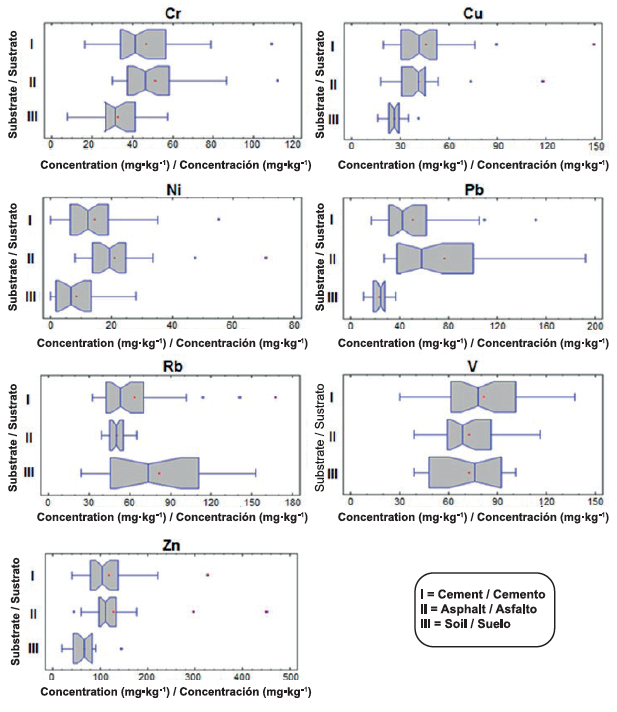
The main roads are paved and is where most vehicular flow takes place, producing the most burning of gasoline, wear of engines, brake pads, asphalt and ash emissions, provoking that urban dust accumulates higher concentrations of HM. Residential areas commonly have secondary and tertiary roads (mostly made of cement), while peri-urban and agricultural areas have unpaved roads that in many cases are uncovered soils that do not have high concentrations of HM.
Spatial distribution of heavy metals
Spatial distribution models (exponential, spherical and Gaussian) with values of r2 between 0.63 and 0.96 were obtained, indicating that there was a high degree of fit between theoretical and experimental models, mainly for Pb, Rb and Ni. The reason of the structural variance showed values of 79 to 92 % with a small nugget-random variance (Co) between 8 and 21 %, therefore, the models selected were suitable for data interpolation (Table 2; Figure 2).
Table 2 Characteristics of semivariograms of heavy metal concentrations in urban dust of Ensenada, Baja California.
| Heavy metal | Model | Correlation coefficient (r2) | Nugget variance (Co, %) | Structural variance (%) | Distance (Degrees) |
| Pb | Spherical | 0.96 | 8 | 92 | 0.060 |
| Rb | Exponential | 0.96 | 17 | 83 | 0.015 |
| Ni | Exponential | 0.92 | 13 | 87 | 0.040 |
| Cu | Gaussiano | 0.79 | 27 | 73 | 0.043 |
| Cr | Exponential | 0.75 | 20 | 80 | 0.032 |
| Zn | Exponential | 0.64 | 20 | 80 | 0.045 |
| V | Exponential | 0.63 | 21 | 79 | 0.030 |
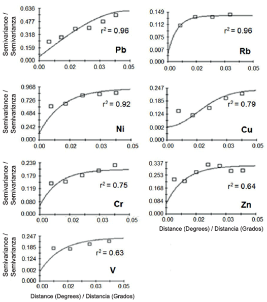
Figure 2 Variogram models with ordinary kriging at concentrations of heavy metals (Pb, Rb, Ni, Cu, Cr, Zn, V) in urban dust of Ensenada, Baja California.
The maps of Figures 3 and 4 show that the southwestern area of Ensenada has the highest concentrations of Pb, Zn, Cu and Ni, specifically near the port, while the highest concentrations of Cr are found in the north of Ensenada. V has high concentrations to the north, northwest, west and in a small area to the south near the port. Figure 5 shows that there are high concentrations of Rb to the east and north of the city. The samples of urban dust show high concentrations of Pb, Zn, Cr, Cu and Ni on industrial and commercial soils, near the port and along the transpeninsular road (Figures 3 and 4). Table 3 reports that HM with high percentages of polluted area, taking into account the highest quintile, are Cr, Zn and Cu.
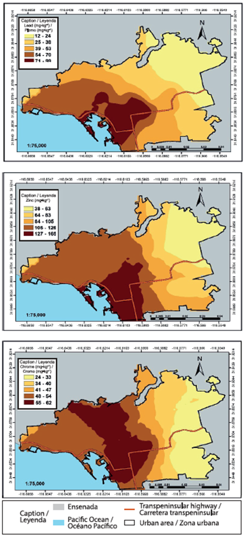
Figure 3 Spatial distribution of the concentrations of Lead, Zinc and Chrome in urban dust of Ensenada, Baja California.
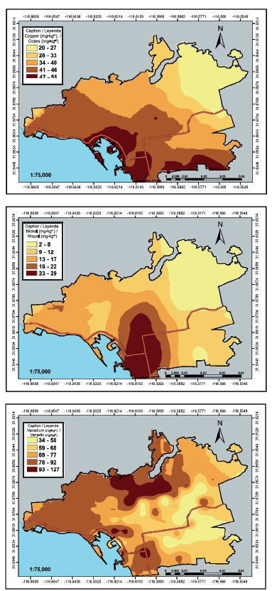
Figure 4 Spatial distribution of concentrations of Copper, Nickel and Vanadium in urban dust of Ensenada, Baja California.
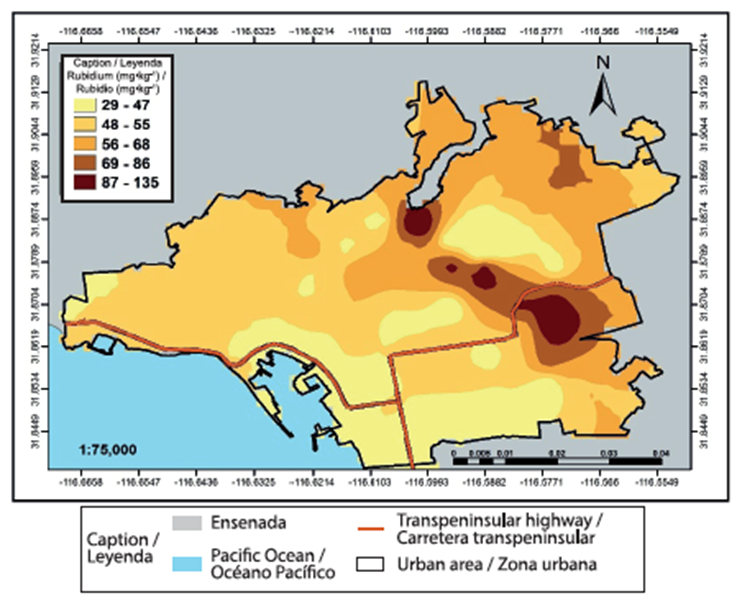
Figure 5 Spatial distribution of concentrations of of rubidium in urban dust of Ensenada, Baja California.
Table 3 Most polluted surface by heavy metals in Ensenada, Baja California.
| Heavy metal | Higher concentration range (mg·kg-1) | Area (ha) | Area (%) |
| Cr | 55 a 62 | 13.96 | 15.82 |
| Cu | 47 a 55 | 12.11 | 13.73 |
| Zn | 127 a 165 | 11.92 | 13.51 |
| Ni | 23 a 29 | 6.39 | 7.25 |
| Rb | 87 a 135 | 1.57 | 1.79 |
| Pb | 71 a 99 | 7.62 | 8.64 |
| V | 93 a 127 | 4.45 | 5.05 |
The map of Figure 6 shows the classes of higher concentration for each metal. Table 4 reports the integration surfaces with the highest concentration intervals for each heavy metal. The surface in which five elements coincide occupies an area of only 1.98 %, later three classes of three heavy metals with surfaces of 5.99, 3.89 and 9.4 % were formed. In total, 21.26 % of the surfaces of the study area requires short-term attention for the mitigation of contaminants.

Figure 6 Map containing the highest concentration of heavy metals in urban dust of Ensenada, Baja California.
Table 4 Integration areas with higer concentratin ranges for each heavy metal.
| Heavy metal | Total area polluted by intersections | |
| Area (ha) | Area (%) | |
| V, Pb, Zn, Ni, Cu, Cr | 100.91 | 1.98 |
| Pb, Zn, Ni | 305.53 | 5.99 |
| Zn, Ni, Cu | 198.07 | 3.89 |
| Pb, Cu, Zn | 479.60 | 9.40 |
| Pb, V | 31.07 | 0.61 |
| Pb, Cr | 502.04 | 9.83 |
| V, Ni | 30.86 | 0.60 |
| V, Rb | 20.67 | 0.40 |
| V, Cr | 212.09 | 4.15 |
| Zn, Ni | 484.72 | 9.50 |
Pollution levels do not exceed the NOM-147 in the case of Pb and Ni; however, authorities should be alert because if we consider the differences between the lowest quintile classes (background or natural levels) and the highest quintile, shown in the maps, there are places with HM concentrations above background levels occupying small surfaces.
As for Cr and Zn there is no pollution threshold in the NOM-147; however, both metals exceed background content. These metals occupy the largest surface of the study area. Cr is particularly dangerous because of its high oxidizing and destructive soft tissue (mucous) power. In this particular case it is necessary to know the concentrations of species of Cr, since Cr VI is the chemical species of greatest risk for the population (Covelo, Vega, & Andrade, 2007; González-Flores, 2011).
V is the heavy metal that may already be causing problems in the population, because there are small areas in which the concentration exceeds the NOM- 147. A sanitation plan should be implemented for these places, since V is an element that if it is inhaled or ingested orally or direct person-to-person via the dermis, causes cancer, affects reproduction and is bioaccumulative (Méndez, Báez, & Patricia, 2014; Rodríguez-Mercado & Altamirano-Lozano, 2006).
Whereas environmental pollution is “the presence in the environment of any agent in places, forms and concentrations that can be harmful to the health, safety or well-being of the population”, it can be said that in this study we identified harmful agents such as heavy metals, places and concentrations; the evaluation of chemical forms of heavy metals, using techniques of sequential extraction and toxicity in the population, is a pending study (Bautista, 1999; Covelo et al., 2007; González-Flores, 2011).
Conclusions
The urban dust collected on the asphalt has the higher concentrations of Cr, Ni, Pb and Zn. This is due to the fact that the primary roadways are regularly paved and have the highest traffic flow, being able to be the main cause of higher concentrations. The Rubidium is found naturally on soils in the north and west of the city. Maps show that the urban dust in the southwestern area of Ensenada (the port area) has the highest concentrations of Cr, Cu, Zn, Ni and Pb; however, high priority areas are those polluted with V, Pb and Zn. The map of the integration of the classes of higher concentration of each metal allowed to identify the most polluted area and, therefore, the area of high priority for the development of remediation actions for dust polluted by HM.

