


 text in
  English (pdf)
 Article in xml format
 Article references
 Send this article by e-mail
 Cited by SciELO
  Similars in
SciELO
Similars in
SciELO 
 Permalink
Introduction
The climate of the Earth has varied continuously for more than 4,500 million years (Sánchez-Cohen et al., 2011). However, since the industrial revolution, humanity has generated pressures on the environment and climate, causing destabilization of different life support systems and drastically modifying their state of equilibrium as a consequence (IPCC, 2014; Olabe-Egaña, 2016). This disequilibrium, in addition to the exposure to extreme climatic phenomena, such as tropical cyclones and hurricanes, among others, has generated conditions of high vulnerability to climate change in Mexico (Conde-Álvarez & Palma-Grayeb, 2006; Monterroso & Conde, 2015). This situation has been observed throughout history, manifested in the loss of human lives and the economic impacts generated. If the trend continues, estimations point out that the problems will become more acute with the increase in the global temperature of the planet (IPCC, 2014; SEDATU, 2016; SEMARNAT, 2013). In Mexico, just during the period 2000 to 2016, 22,279 emergencies were declared at the national level, for different phenomena related to climatic change (CENAPRED, 2019).
At the basin level, vulnerability to climatic change is presented by a lack of preventative measures, irregular location of human settlements over the banks of rivers, and the poor management of these settlements (Bitrán, 2001; Olabe-Egaña, 2016). This vulnerability could even be increased by the direct effect of land-use change (Ruiz-Barradas, 2012), which translates into the loss of environmental services, such as protection provided by the hydrographic basin, biodiversity richness and carbon capture (Pagiola et al., 2003).
In particular, the Río Misantla basin, located in the mountainous central zone of Veracruz State, in Mexico, is characterized by the presentation of rugged geomorphology and areas that are devoid of vegetation. This basin has seen various climatic events, such as hurricane Roxana in 1995, hurricane Stan in 2005, hurricanes Karl and Matthew in 2010, and the tropical storms Barry and Fernand in 2013. These events have generated impacts due to underwater sediment dragging, causing flooding that has led to the loss of crops, livelihoods, infrastructure, and human lives (Tejeda-Martínez, 2006; Tejeda-Martínez et al., 2012).
In this context, one form of evaluating the vulnerability of a hydrographic basin exposed to extreme climatic phenomena and observing the effect of bad management practices and their impact on the landscape characteristics is through the use of an indirect model, which consists of determining the hydric balance using informatic modeling tools (Benavides-Solorio et al., 2008; Logreira Rentería, 2009). These models use temporal and spatial variables to simulate water flows into and out of a given area, considering all stages of the hydrological cycle (Abad, 2006; Isabel et al., 2004).
The objective of this study was to analyze the impact of land-use change on the hydric balance of the Río Misantla basin during the period 2000 to 2014 and determine its relationship to increased vulnerability to extreme climatic phenomena.
Material and Methods
Study area
The study was conducted in the Río Misantla basin, located in the mountainous central zone of Veracruz State, in Mexico, in hydrological region number 27 Tuxpan - Nautla. This basin covers an area of 585.76 km2 and occupies 12 municipalities, all within Veracruz State (Figure 1).

Source: INEGI (1990). State political division scale 1:4 000 000
INEGI (2010). Hydrographic Network. Scale 1:50 000 edition 2.0
Figure 1 Location of the Misantla river basin.
The basin is located in the physiographic sub-provinces known as “Sierra de Chiconquiaco” and “Llanuras y Lomerios” (INEGI, 2001). This mountain chain presents abrupt and distinct units until reaching a zone of rounded low hills, associated with gullies and plateaus (Medina-Chena et al., 2010). The topography of the basin is very varied; it presents elevations ranging from sea-level to 2,680 masl within a range of 55.5 km. Twelve different edaphic units are presented along the basin (INEGI, 2013a).
The basin comprises multiple streams and runoffs, among which are Río Palmas, known previously as the Río Grande, and Río Palchán, which combine to form the Río Misantla that gives its name to the basin, finally discharging into the Gulf of Mexico at Barra de Palmas. The maximum mean temperature in the basin is 33 °C while the minimum is 22.8 °C, with an annual mean accumulated precipitation of 1,662 mm (CONAGUA, 2015a).
The basin presents diverse ecosystems, being the most important tropical montane cloud forest (INEGI, 2013b). According to the latest statistics of the National Institute of Statistic and Geography (INEGI, 2010), the total human population of the basin is 59,956 inhabitants, of whom 27,051 are men and 28,585 are women, distributed among 202 localities that mainly present medium and high indices of marginalization (CONAPO, 2010).
Determination and modeling of the hydric balance
The hydrological balance was determined using SWAT (soil and water assessment tool). Topographic (elevation model), edaphological (soil types and their physicochemical properties), land use and vegetation, hydrological and climatic (Figure 2) data were required by the model (Arnold et al., 2012; Winchell et al., 2008).

Source: (Arnold et al., 2012; Winchell et al., 2008).
Figure 2 Flow char to process information in SWAT.
Once all of the layers of information were categorized and entered, the input databases were generated and a period of 15 years (2000 - 2014) simulated, from which the output data were created. At the end of the simulation, the efficiency of the model was validated to verify the certainty of the data obtained through calculation of the coefficient of determination (R2) and the coefficient of efficiency (E) of Nash & Sutcliffe (1970) (Equation 1).
Where Qo represents the observed or true cost, Qm the simulated cost, T the sum of the times analyzed, and t the time of analysis.
To evaluate the effect of the land use and vegetation on the behavior of the hydrological variables in the Río Misantla basin, two scenarios were created: one deforested and the other forested.
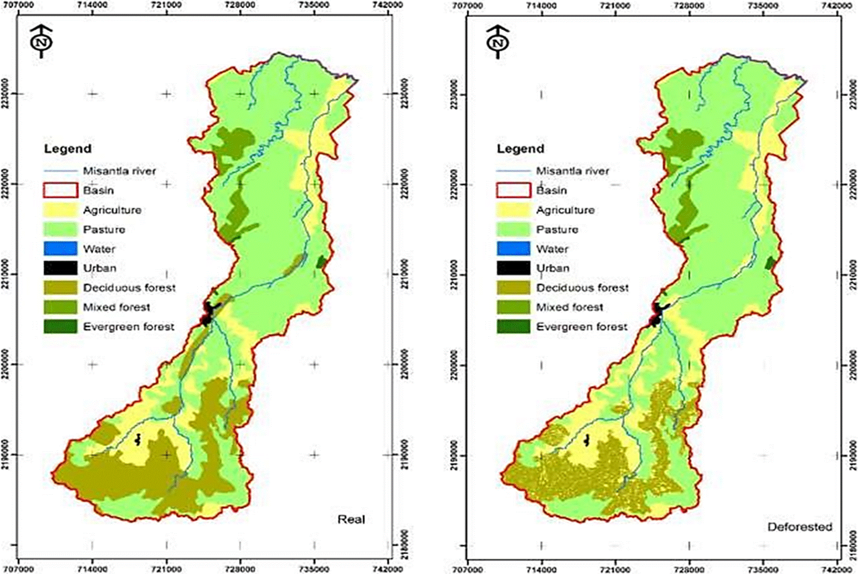
For the deforested scenario, areas with tropical montane cloud forests from the upper and mid parts of the basin (FRSD) and slopes of less than 40 % were selected and reclassified as agricultural zones (AGRL). The area of the land-use change corresponded to 3,101.66 ha, equivalent to a reduction of 25.75 % of the initial forested area (Figure 3).
In contrast, to analyze the effect of forestation over the upper part of the basin, agricultural (AGRL) and livestock production (PAST) areas with slopes greater than 40 %, which could recover their forested coverage, were selected. These areas were reclassified as forested zones (FRSD), contributing to an increase in the forest coverage of 3,362.38 ha, which was equivalent to 27.91 % of the initial area (Figure 4).

To determine whether there were differences in the hydrological behavior of the basin between these two simulated scenarios, a one-way analysis of variance (ANOVA) was conducted for seven hydrological variables, with a level of significance of α = 0.05.
Results and Discussion
According to the results of the hydric balance modeled by SWAT (Table 1), the Río Misantla basin exceeds by 16.51 % the annual mean precipitation of the State of Veracruz (INEGI, 2015), and 57.81 % and 51.46 % more than the national mean, according to the World Bank (2015) and the National Water Commission (2015b), respectively. From the data obtained, 9.38 % of the precipitation runs off over the surface, 1.13 % flows to the ocean through subterranean currents (deep percolation), 84.31 % is evapotranspirated, while 63.10 % the water produced in the system runs off over the surface. Percolation is 0.34 % greater than the total recharge of the soil, thus, all of the water that percolates recharges the aquifers of the basin.
Table 1 Hydrology modeled by SWAT.
| YEAR | PREC (mm) |
SURQ (mm) | LATQ (mm) |
PERC (mm) |
SW (mm) |
ET (mm) | PET (mm) |
WY (mm) |
SY (ton-1ha-1 año-1) |
|---|---|---|---|---|---|---|---|---|---|
| 2000 | 2,037.13 | 99.10 | 100.57 | 15.35 | 44.26 | 1,862.19 | 21,366.26 | 199.88 | 22.22 |
| 2001 | 1,902.66 | 132.50 | 110.95 | 22.51 | 11.44 | 1,671.38 | 21,717.89 | 244.85 | 8.77 |
| 2002 | 1,381.97 | 93.22 | 82.41 | 12.43 | 17.52 | 1,188.54 | 22,544.96 | 176.22 | 8.44 |
| 2003 | 1,469.64 | 117.53 | 89.17 | 11.71 | 18.50 | 1,249.41 | 22,576.97 | 207.31 | 12.32 |
| 2004 | 1,822.25 | 235.50 | 99.85 | 22.42 | 22.45 | 1,460.94 | 21,920.42 | 336.25 | 16.22 |
| 2005 | 2,198.82 | 294.16 | 118.43 | 31.12 | 31.44 | 1,744.97 | 20,908.04 | 413.81 | 27.45 |
| 2006 | 1,572.02 | 215.58 | 82.80 | 23.55 | 34.30 | 1,247.14 | 21,870.84 | 299.68 | 18.86 |
| 2007 | 1,938.66 | 144.88 | 98.21 | 23.71 | 29.44 | 1,675.99 | 21,602.77 | 244.45 | 13.52 |
| 2008 | 1,665.33 | 116.24 | 96.87 | 15.90 | 8.16 | 1,459.24 | 22,109.80 | 214.06 | 10.82 |
| 2009 | 1,946.54 | 193.27 | 100.83 | 26.00 | 55.79 | 1,576.77 | 21,486.01 | 294.85 | 17.04 |
| 2010 | 1,904.61 | 258.60 | 111.94 | 31.80 | 33.67 | 1,525.05 | 21,861.06 | 372.26 | 29.79 |
| 2011 | 1,871.64 | 236.16 | 105.84 | 22.93 | 43.89 | 1,495.76 | 21,706.99 | 343.27 | 32.21 |
| 2012 | 2,001.66 | 177.45 | 99.14 | 20.93 | 35.77 | 1,712.32 | 21,286.04 | 277.84 | 14.70 |
| 2013 | 1,703.84 | 156.83 | 88.46 | 14.51 | 26.31 | 1,454.58 | 21,607.43 | 246.10 | 15.02 |
| 2014 | 1,534.70 | 57.73 | 78.00 | 11.30 | 15.04 | 1,399.02 | 21,322.15 | 136.38 | 5.25 |
| Mean | |||||||||
| 1,796.76 | 168.58 | 97.56 | 20.41 | 28.53 | 1,514.89 | 21,725.84 | 267.15 | 16.84 | |
PREC = precipitation; SURQ = surface runoff; LATQ = lateral flow; PERC = amount of percolating water; SW = soil water content; ET = actual evapotranspiration; PET = potential evapotranspiration; WY = water yield; SY = sediment yield.
Source: SWAT output database.
On comparison of a year with low precipitation with another of high precipitation, as a result of the incidence of climatic combined phenomena, such as hurricane Stan and tropical storm Bret in 2005, differences are observed in the variables predicted by the model for this basin (Table 2), showing that the arrival of hydrometeorological phenomena from the coast of the Gulf of Mexico puts the population at risk due to the increase in surface runoff and the dragging and transport of sediments in the water towards the lower parts of the basin (Tejeda-Martínez, 2006), which increases the risk of flooding (IPCC, 2001; SEDATU, 2016).
Table 2 Hydrology modeled by SWAT in years with different rainfall.
| Parameter | 2002 (Low rainfall) | 2005 (High rainfall) | Variation | % of change |
|---|---|---|---|---|
| PREC (mm) | 1,381.97 | 2,198.82 | 816.85 | 59.11 |
| SURQ (mm) | 93.22 | 294.16 | 200.94 | 215.55 |
| LATQ (mm) | 82.41 | 118.43 | 36.02 | 43.71 |
| PERC(mm) | 12.43 | 31.12 | 18.69 | 150.36 |
| SW (mm) | 17.52 | 31.44 | 13.92 | 79.45 |
| ET (mm) | 1,188.54 | 1744.97 | 556.43 | 46.82 |
| PET (mm) | 22,544.96 | 20,908.04 | -1,636.92 | -7.26 |
| WY (mm) | 176.22 | 413.81 | 237.59 | 134.83 |
| SY (ton/ ha-1/año-1) | 8.44 | 27.45 | 19.01 | 225.24 |
PREC = precipitation; SURQ = surface runoff; LATQ = lateral flow; PERC = amount of percolating water; SW = soil water content; ET = actual evapotranspiration; PET = potential evapotranspiration; WY = water yield; SY = sediment yield.
Source: SWAT output database.
The modeled scenarios (Table 3) demonstrate that the vegetation in the upper part of the Río Misantla basin is important to maintain the processes and equilibrium of the water cycle through the imposition of a direct effect on its functioning (Paré & Gerez, 2012), showing that the forests act to significantly reduce soil erosion, dragging of sediments to deposits and the risk of landslides and flooding (Armenta-Montero, 2012; García-Chevesich, 2010; Manson, 2004). With this, the vulnerability of the population to the impact of hydrometeorological phenomena is reduced.
Table 3 Hydrology modeled by SWAT by scenario.
| Parameter | Real scenario | Mean Deforested scenario | Forested scenario |
|---|---|---|---|
| PREC | 1,796.76 mm | 1,796.76 mm | 1,796.76 mm |
| SURQ | 168.58 mm | 190.34 mm | 159.81 mm |
| LATQ | 97.56 mm | 71.55 mm | 102.40 mm |
| PERC | 20.41 mm | 20.28 mm | 21.50 mm |
| SW | 28.53 mm | 30.42 mm | 27.61 mm |
| ET | 1,514.89 mm | 1,519.15 mm | 1,517.78 mm |
| PET | 21,725.84 mm | 21,725.84 mm | 21,725.84 mm |
| WY | 267.15 mm | 262.89 mm | 263.26 mm |
| SY | 16.84 ton-1ha-1 año-1 | 18.51 ton- 1ha-1 año-1 | 7.38 ton-1ha-1 año-1 |
PREC = precipitation; SURQ = surface runoff; LATQ = lateral flow; PERC = amount of percolating water; SW = soil water content; ET = actual evapotranspiration; PET = potential evapotranspiration; WY = water yield; SY = sediment yield.
Source: SWAT output database.
The ANOVA for the seven hydrological variables modeled by SWAT found significant differences among surface runoff (SURQ) and sediment yield (SY) (Table 4).
Table 4 Comparison chart of ANOVA´s for seven hydrological variables along the Misantla river basin.
| Parameter | Mean | Standard deviation | Degrees of freedom | F | P |
|---|---|---|---|---|---|
| Surface runoff (SURQ) | 172.9 | 69.18 | 2 | 0.7665 | 0.47102 |
| Lateral flow (LATQ) | 90.51 | 17.41 | 2 | 34.178 | 0.00000 |
| amount of water percolating (PERCOLATE) | 20.73 | 6.72 | 2 | 0.1447 | 0.86567 |
| soil water content (SW) | 28.85 | 13.1 | 2 | 0.1715 | 0.84297 |
| Actual evapotranspiration (ET) | 1517 | 191.8 | 2 | 0.002 | 0.99815 |
| Water yield (WYLD) | 264.4 | 75.53 | 2 | 0.0140 | 0.98612 |
| Sediment Yield (SYLD) | 14.24 | 8.566 | 2 | 10.5724 | 0.00019 |
Validation of the SWAT model
The values obtained in the validation of the model for the Río Misantla basin produced a coefficient of determination (R2) = 0.89 and an Efficiency of the model (ENS) = 0.61. According to Ramanarayanan et al. (1997), these data represent a model that is considered acceptable or satisfactory, when R2 > 0.6 and ENS > 0.5. Moriasi et al. (2007) classified the efficiency of the SWAT model as acceptable when the value ENS is between 0.50 and 0.65, but unsatisfactory when ENS is less than 0.50 (Barrios & Urribarri, 2010). For this reason, the SWAT model obtained in this study can be considered reliable for this basin.
These results indicate that the hydrological models implemented through geographic information systems (GIS) allow us to study the causal relationships of the hydric behavior of a basin, obtaining reliable results even when there is a lack of information and suitable infrastructure for collecting field data (Barrios & Urribarri, 2010; Hernández, 2014).
The fitting model (R2 = 0.89; ENS = 0.61) indicates high reliability (Table 5), according to previous studies. However, it is important to consider the acquisition of field data to calibrate and obtain higher values at the time of model validation, thus increasing the degree of confidence in the predictions.
Table 5 Water modeling adjustments with the SWAT tool.
| Year | Basin | Country | R2 | ENS | Author |
|---|---|---|---|---|---|
| 2014 | Río Atulapa | Guatemala | 0.86 | 0.6 | (Hernández, 2014) |
| 2014 | Santa Catalina | Argentina | 0.82 | 0.66 | (Guevara et al., 2014) |
| 2014 | Santa Catalina | Argentina | 0.86 | 0.74 | |
| 2014 | Río Mixteco | México | 0.93 | - | (Salas-Martínez et al., 2014) |
| 2010 | Taquiña | Bolivia | 0.77 | 0.54 | (Zarate, 2010) |
| 2010 | Tolomosa | Bolivia | 0.84 | 0.63 | |
| 2010 | Río Chama | Venezuela | 0.88 | 0.76 | (Barrios & Urribarri, 2010) |
| 2008 | Tapalta | México | 0.85 | - | (Benavides-Solorio et al., 2008) |
| 2008 | Río Amajac | México | 0.59 | 0.94 | (Mata-Espinoza, 2008) |
| 2005 | Río La Laja | México | 0.82 | - | (Torres-Benites et al., 2005) |
| 2004 | El Tejocote | México | 0.93 | 0.85 | (Torres-Benites et al., 2004) |
ENS = model efficiency.
Conclusions
The vegetation of the upper part of the Río Misantla basin has a direct effect on the hydrological cycle and behavior of the basin, protecting it from the impact of extreme hydrometeorological phenomena. This leads us to conclude that it is possible to reduce vulnerability to climatic change in these areas with appropriate management, recuperation and restoration of areas devoid of vegetation and with the regulation of the growth of the agricultural and livestock production footprint.
With tools such as SWAT, it is possible to create a baseline of knowledge that allows modeling of climate change scenarios to support the creation of environmental policies that facilitate conservation and restoration, as well as a reduction in the vulnerability of the Río Misantla basin.

