


 texto en
  Inglés (pdf)
 Artículo en XML
 Referencias del artículo
 Enviar artículo por email
 Citado por SciELO
  Similares en
SciELO
Similares en
SciELO 
 Permalink
Introduction
Due to global warming, climate change has become the greatest threat to society during the 21st century, since the interconnected nature of risks associated with this change affects countless sectors and areas of human life (Mora et al., 2018). Recent scientific studies such as IPCC (2018) and Mora et al. (2018) showed that climate change and variability can adversely impact human health, ecosystems and various socioeconomic sectors. In this context, vital aspects of development and social welfare, such as food production, coastal areas, human settlements, water resources, infrastructure and security are and will be affected by such phenomena. Nonetheless, climate change represents an additional factor that, along with the growing demand for resources, land-use change and pollution, are pressuring natural systems. Climate change will not affect everyone to the same degree; developing countries and the most vulnerable social groups will be the most affected (Mateos et al., 2016). In the Mesoamerican and Caribbean regions, challenges in this regard are growing (González et al., 2017; Muñoz‐Jiménez et al., 2019).
Therefore, in the context of global change and its effects on the hydrological cycle, water resource management is a worldwide challenge by facing some of the most serious problems in water resources at short-term, such as the growth in water demand, water pollution, climate change, and disturbances of the ecosystems (Magaña et al., 2018). The availability of water and changes in precipitation, as evidenced by droughts and aquifer depletion, substantially impacts both urban and rural areas (Duran-Encalada et al., 2017). Mexico is considered one of the most susceptible countries because of its strong vulnerability to the adverse effects of climate change. According to Molina et al. (2017), 15 % of the national territory, 68 % of the population, and 71 % of the Gross Domestic Product (GDP) are extremely exposed to direct adverse effects of climate change. Climate variability is related to natural events such as floods and tropical storms, adverse effects of activities such as agriculture and hydroelectric generation, and socioeconomic losses throughout Mexico (Landa et al., 2008; Magaña et al., 2001). In particular, the southern border presents a great exposure to impacts of climate variability and climate change, where floods represent one of the major problems in the transboundary basins of this area (García & Kauffer, 2011; Kauffer, 2006). However, both institutional and socioeconomic response capacities to these phenomena in the area are considered to be limited (CAFS, 2018). This situation is not exclusive of Mexico, because challenges in this area are shared to a greater or lesser extent by other countries in the region.
In this context, south-eastern Mexico has an extensive natural wealth, including water resources, which are mainly within the Grijalva and Usumacinta basins (Cruz-Paz et al., 2018; García & Kauffer, 2011), these basins are geographically adjacent. The modulators of climate variables, such as precipitation in this region, are mainly waves and tropical cyclones during summer and cold fronts in winter (Andrade-Velázquez, 2017). Precipitation behaviour can be assessed by the standardized precipitation index (SPI), which provides information on wet and dry periods in a region (Santana et al., 2017). This information is necessary to determine changes in regional precipitation patterns at different time scales, e.g., seasonal, annual or greater periodicity. Nonetheless, climate data in Mexico and tropical areas are scarce, and their quantitative and qualitative availability has resulted in very few studies on the evidence and trends of climate change in the country (Duncan-Golicher & Morales, 2005; Montero-Martinez et al., 2018). In different regions, reanalysis data have been used to supply the observation records (Cavazos et al., 2019). This posed a challenge to the present investigation, because knowing and understanding the climate is essential to analyse precipitation changes as a critical climate variable.
In this perspective, the present study explored and analysed precipitation patterns in the Usumacinta and Grijalva transboundary basins from a natural point of view, i.e., involving natural and hydrographic delineation of these water spaces including Guatemala and Belize. Thus, because the Mexican side is a receiving basin, the present study sought to understand rainfall patterns in these basins, which are represented as a natural unit. Therefore, the study aimed to increase the knowledge and to promote climate resilience in the region. On this basis, we concluded that our approach can promote not only research on the subject, highlighting the knowledge generation for basins under various contexts, but also the decision-making of those basins involved in the challenges of water resource management in the study area.
Materials and Methods
Study Area
The southern border area of Mexico comprises six watersheds covering a total area of ~168,349 km2 (Usumacinta, Grijalva, Candelaria, Hondo, Suchiate, and Coatán basins), which extends across Mexico, Guatemala and Belize. In particular, the Grijalva and Usumacinta basins (which together are called the entire basin hereafter) have great natural capital, because of their importance, extent and hydrological development. The area of the Usumacinta basin (72,118 km2) is divided between Mexico (42 %) and Guatemala (58 %), with a lesser proportion in Belize (0.0002 %). Of the Grijalva Basin area (57,682 km2), 90.5 % is estimated to be in Mexico and 9.5 % in Guatemala. Within Mexico, the Grijalva and Usumacinta basins have a total area of 82,478 km2 or 4.2 % of the country’s continental territory. The administrative distribution of the two basins in Mexico includes the states of Tabasco, Chiapas, and a small part of Campeche (Figure 1).

Figure 1 Location of the Grijalva and Usumacinta basins (QGIS Desktop 3.10.0, World Hydro Basemap: HydroTeamRC).
The Grijalva and Usumacinta basins comprise not only one of the regions with tremendous biological and cultural diversity but are also the headwaters of important rivers. These rivers include the Usumacinta, Grijalva, San Pedro, and Lacatún. In fact, the Usumacinta River has the greatest flow in Mesoamerica, estimated at 1,700 m3/s (March-Mifsut & Castro, 2010). Indeed, the Grijalva-Usumacinta hydrologic system is responsible for 30 % to 40 % of the surface water runoffs in Mexico (García & Kauffer, 2011; March-Mifsut & Castro, 2010). Furthermore, according to the National Institute of Ecology and Climate Change (INECC, its Spanish acronym), 67 % of living species in the country are found in these basins. There include important protected areas such as the Pantanos de Centla Biosphere Reserve and the Lacan-Tun, El Triunfo and other protected natural areas. Coexisting activities are agriculture, cattle raising and hydroelectric generation. The Grijalva and Usumacinta basins embrace a total population of ~5 million.
Methods
The SPI was used to determine precipitation patterns in the Grijalva and Usumacinta basins. The main importance of this index was explained in the Introduction section. The Standardised Precipitation Evapotranspiration Index (SPEI) is known to be an index of coupled temperature and precipitation, it proposes determining the local factor but it only determinates the effect on the precipitation change. The SPI was used in the present study, since the SPEI showed a delay in drought occurrence (Castillo-Castillo et al., 2017). This index was classified as shown in Table 1 and its use was suggested by the World Meteorological Organization (WMO) for drought studies (Mckee et al., 1993; WMO, 2012). Key sites in the basin (Figure 2) were selected according to their relative location to the important surface water mantles of the basin, i.e., near the Grijalva and Usumacinta rivers or their tributaries. The SPI was calculated using the equation Pearson type III distribution (Guttman, 1999).
Where a, b>0 for scale and shape parameters and 0<c<x for location parameter, Γ is the gamma function.
Table 1 SPI classification system.
| SPI value* | Category |
|---|---|
| ≥ 2.0 | Extremely wet |
| 1.5 to 1.99 | Severely wet |
| 1.0 to 1.49 | Moderately wet |
| −0.99 to 0.99 | Near normal |
| −1.0 to −1.49 | Moderately dry |
| −1.5 to −1.99 | Severely dry |
| ≤ −2.0 | Extremely dry |
Source. WMO (2012).
Note. * SPI values < -1 indicate a condition of drought. The more negative the value is, the more severe the drought condition. SPI values > 1 indicate wetter conditions compared to the climatology.
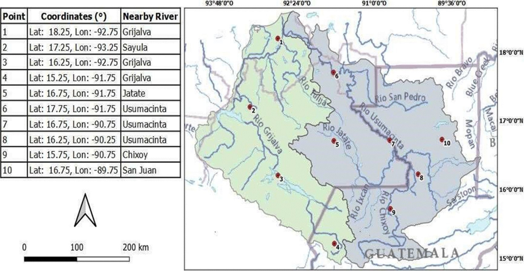
Figure 2 Location of key sites in the Grijalva and Usumacinta basins. (QGIS Desktop 3.10.0, World Hydro Basemap: HydroTeamRC).
Data
Precipitation data were taken from the CRU TS4.01 database: Climatic Research Unit (CRU) TimeSeries (TS) version 4.01, high-resolution gridded data of month-by-month variation in climate (January 1901- December 2016) (University of East Anglia Climatic Research Unit, Harris, & Jones, 2017). These data have a spatial resolution of 0.5° × 0.5°. Thus, determination of the temporal evolution of the SPI from 1960 to 2016 at different timescales (3, 12 and 36 months) allowed us to identify wet and dry periods on seasonal, annual and three-year bases near the rivers of the Grijalva and Usumacinta basins. In this region, degradation has been reported, associated with anthropogenic intervention in various areas (Gama et al., 2010; Haer et al., 2017).
Results and Discussion
Precipitation Climatology
Precipitation climatology of the Grijalva-Usumacinta basin was shown in Figure 3a. The high precipitation patterns were observed to be located in the upper basin, at the south border of Mexico, and at the northwest of the basin (Tabasco). The annual precipitation amount in these zones were ~ 2,500-2,880 mm from 1960 to 2016. While the low precipitation zones were located at the southwestern and northeastern areas of the basin (~1000 - 1800 mm). This result showed that the Usumacinta basin was wetter than the Grijalva basin. However, seasonal differences were observed along the year, Figures 3b and 3c showed the precipitation climatology during summer and winter, respectively. The patterns remained similar during winter with a similar precipitation amount due to cold fronts, while they differed in summer. The upper basisn presentaed the higher precipitaction amount than in the rest of the basin. During summer, this precipition was due to tropical systems as Cyclons or Intertropical Convergence Zone (ITCZ).
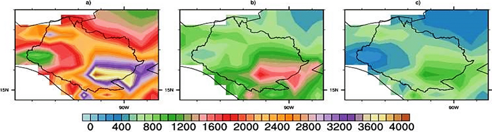
The high precipitation was located in the upper basin and at the northwest and the low precipitation was located in inverse directions.
Note. The polygonal zone corresponds to the delimitation of the Usumacinta and Grijalva basins and the units were expressed in mm.
Figure 3 Precipitation climatology in the Grijalva and Usumacinta basins from 1960 to 2016: a) annual, b) summer and c) winter.
SPI Patterns
Figure 4 and Figure 5 showed the three SPI time windows. At all points, values of SPI-3 (seasonal window) were +2 to −2, i.e., quarterly periods from 1960 to 2016 were from severely wet to severely dry. The precipitation behaviour was very similar at all points. However, in the Usumacinta region, there were extremely dry events around 1998; in the Grijalva region they occurred in 1960, 1970, 1980, 2003 and 2005.
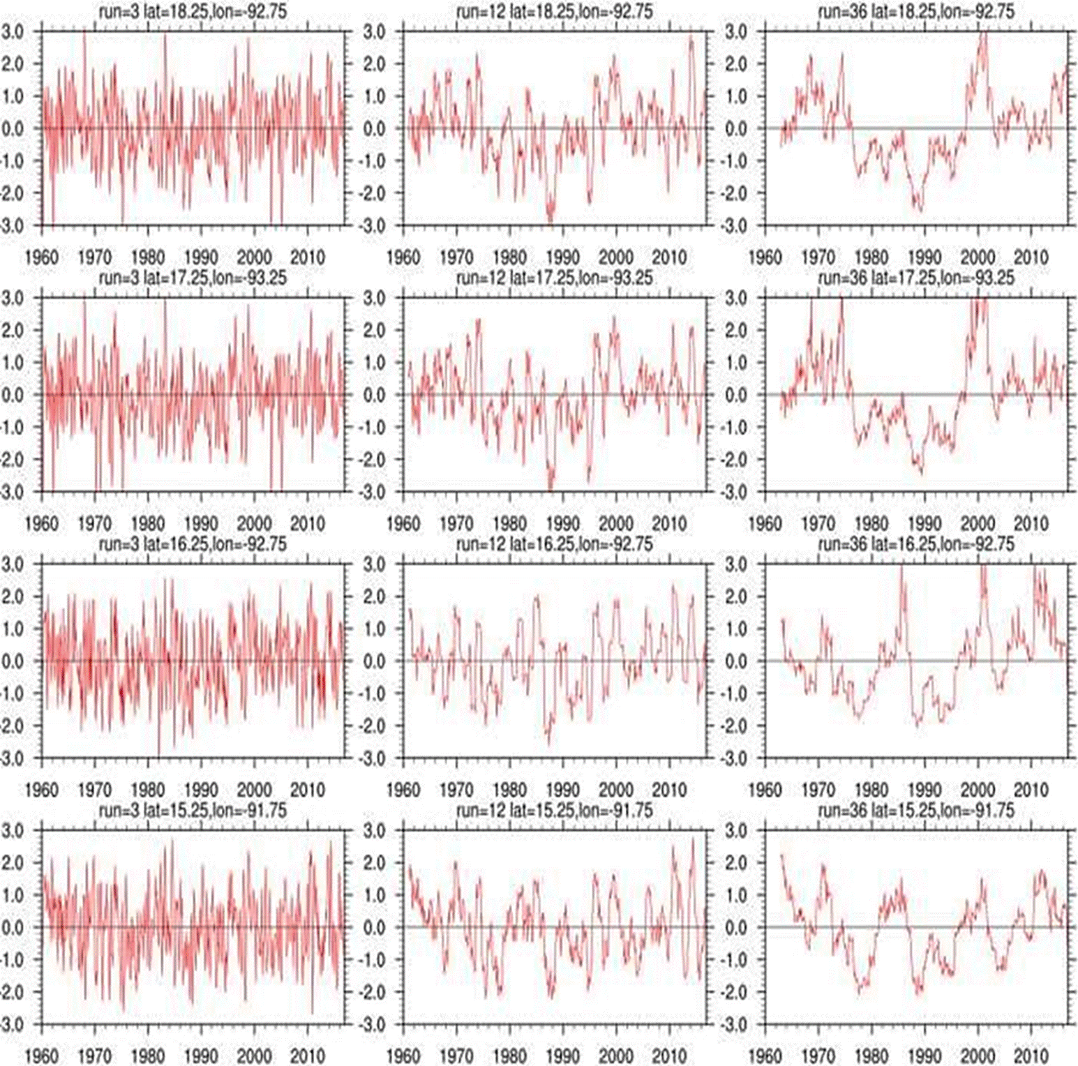
The first column corresponds to the SPI-3, the second one to the SPI-12 and the third one to the SPI-36.
Note. The order is following coordinates of the Figure 2.
Figure 4 SPI (at 3, 12, and 36 months) from 1960 to 2016 for the Grijalva (red) basin.
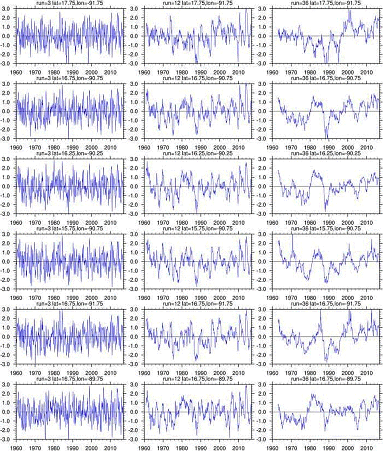
The first column corresponds to the SPI-3, the second one to the SPI-12 and the third one to the SPI-36.
Note. The order is following coordinates of the Figure 2.
Figure 5 SPI (at 3, 12, and 36 months) from 1960 to 2016 for the Usumacinta (blue) basin.
For the annual SPI (SPI-12), the evolution at each point varied. This behaviour was not identified by the SPI-3 at none of the points. The SPI-12 values from 1960 to 2016 showed that precipitation behaviour was not homogeneous at all points. There were some exceptions, as for 1998, for which all points showed an extremely dry period. This was not evidenced by the SPI-3. Extremely wet events were more frequent after 2010 in all cases. In the Grijalva basin, the precipitation behaviour was similar at points 1 and 2, and at point 6 in the Usumacinta basin. In agreement with SEMARNAT (2016), the regional transformation was strong or very strong because of human influence. The precipitation evolution was similar at points 4, 5, 8 and 9 (all in the Usumacinta basin except point 4). This could be due to the fact that at these points, the land was covered with vegetation of a tropical rainforest. The SPI-12 variation was not similar between the remaining points (3, 7 and 10). Points 1, 2 and 3 differed from the rest of the points, showing a drier period from 1975 to 1995, while the other points indicated a wet period. At that time, the Pacific Decadal Oscillation (PDO) phase was negative and the La Niña events occurred. This result indicated that the different response to the climate modulator at each point could suggest a local influence of other factors, such as environmental factors.
For the three-year window SPI-36, precipitation pattern behaviour was very similar to the one of the SPI-12, but better defined. In the north of the entire basin, there was a dry period from 1978 to 1998. In the central basin, this dry period occurred as well, but also a maximum, i.e., a wet period, between 1980 and 1990. At that time, the La Niña phase could have produced the wet event. There were other wet events after 2000, where the La Niña events could have been present and where the PDO phase was negative. Eastern areas of point 10, showed that the dry period began in 1962, i.e. it was longer; in this case the El Niño South Oscillation (ENSO) phase tended to warm. In the southern basin, the precipitation evolution was nearly identical to the central area, but the dry period was from 1970 to 2000 and wet events occurred after 2005. In addition, more extremely wet events were evidenced at points 1, 2 and 3 (Grijalva, Figure 4), and at points 5 and 6 (Usumacinta, Figure 5); at least one of these events was evidenced at all points (during the year 2000).
In particular, the present SPI-3 results showed that wet and dry events were similar across the Grijalva and Usumacinta basins. But the SPI-3 in the Grijalva basin showed more frequency of dry periods than in the Usumacinta basin, this result was comparable with the precipitation climatology, where the Grijalva basin showed the lower annual, summer and winter precipitation amount from 1960 to 2016. As well, the SPI-3 results presented a high precipitation amount at the points in the Usumacinta basin (Chiapas and Tabasco) and for some ones in the Grijalva basin (Tabasco).
However, the SPIs with larger windows (e.g., SPI-12) presented notable differences (Figure 4 and 5). Precipitation characteristics for the SPI-12 showed values around zero at the points in the Usumacinta basin, whereas the points in the Grijalva basin showed periods with negative values, indicating a long dry period. These processes were described below.
Santana et al. (2017) reported extremely dry and wet events using the SPI-12 from 1985 to 2008 for the Usumacinta basin (Mexican portion only). These results concurred with the results obtained in this study, with extremely dry and wet events in the same period. These events could be related to the ENSO phases, this will be discussed further in the present paper. The severely dry, moderate dry, and wet events occurred from 1961 to 1985, in agreement with Santana et al. (2017) as well.
The SPI-36 revealed that precipitation varied geographically. Precipitation in the northern part of the entire basin had a similar behaviour. In the central basin area, the points showed the same precipitation evolution, and at the points located in the southern region, the SPI-36 revealed a parallel evolution as well. The precipitation analyses of González-Villela & Montero-Martínez (2017) showed this pattern only for the Usumacinta basin. The dry period at all points from 1970 to 2000 was associated with climate effects of the Pacific Decadal Oscillation (PDO) and with a weak phase of the Atlantic Multidecadal Oscillation (AMO) (Méndez & Magaña, 2010).
Figure 6 showed the SPI-12 vs. the PDO in the same period and their relationship. Most of the wet events occurred when the PDO was in its negative phase, and the dry events occurred when it was in its positive phase. This finding showed that the relationship was inverse. Méndez-González et al. (2011) showed that precipitation in southern Mexico was influenced by this oscillation and revealed the same regional precipitation behaviour as in our study. Méndez & Magaña (2010) argued that precipitation evolution all over Mexico was modulated by a combination of the ENSO with the PDO and the AMO, indicating a geographic dipole of the precipitation. That is, when the north is dry, the south is wet, and vice versa. Thus, these climate phenomena mainly altered regional precipitation. On the other hand, rainfall trends in southern Mexico and Central America were positive or negative during the 1990s (Dore, 2005; Jauregui, 1997), but different areas experiencing severe drought or wet spells were closely related to the shift in the ENSO towards warmer events since the late 1970s (Dore, 2005). The ENSO’s phases determined the meteorological systems behaviour, as trade winds, cyclones and north winds in the Grijalva-Usumacinta basin. The decrease in cyclones number and the increase in north winds drove to dry periods (Andrade-Velázquez, 2017).
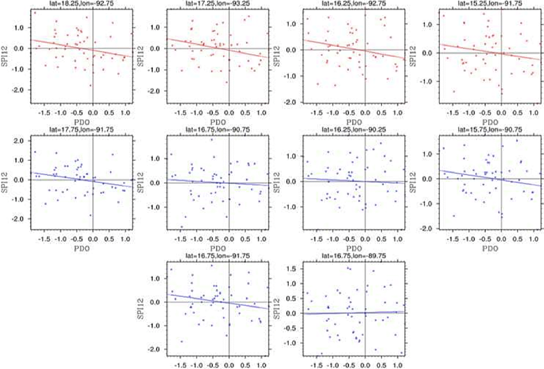
The red points represented the Grijalva basin and the blue ones the Usumacinta basin.
Figure 6 Relationships between the Pacific Decadal Oscillation (PDO) and the Standardized Precipitation Index at 12 months (SPI-12) at each study point from 1960 to 2016.
Figure 7 presented the relationship between the SPI-12 and the Oceanic Niño Index (ONI), one of the El Niño indexes. The trend shown confirmed that the ONI negative phase was associated with positive values of the SPI, i.e., wet events, while the ONI positive phase was associated with dry events in south-eastern Mexico. In this line of research, using local data, Arreguín et al. (2014) reported that during the La Niña event (ENSO cold or negative phase) in 2007, there were intense rainfall events in the southeast of the country. As well, other studies indicated that extreme rainfall events were linked to the La Niña events (Peralta-Hernández et al., 2009; Pérez-Morga et al., 2013).

The red points represented the Grijalva basin and the blue ones the Usumacinta basin.
Figure 7 Relationships between the Oceanic Niño Index (ONI) and the Standardized Precipitation Index at 12 months (SPI-12) at each study point from 1960 to 2016.
A wet period has been observed at all points since 2009. The IPCC (2013, 2014) reported changes in precipitation data using annual anomalies from 1900 to 2010, but it did not mention any trend in the tropics during that period. Over the last 10 years, precipitation events in south-eastern Mexico have been in line with negative phases of the PDO and the ENSO. Mateos et al. (2015) reported that the PDO signal could be possibly present for other regions in the country, in the present work a relationship between the PDO and the SPI-12 was demonstrated for southern Mexico. However, Mateos et al. (2015) found that the precipitation pattern did not show a homogeneous behaviour in several watersheds. Montero-Martínez et al. (2018) showed that from 1965 to 1994, the Usumacinta basin exhibited dry events, which could be associated to the microclimates of complex topographical areas or to changes in the landuse and land-cover.
Guevera-Murua et al. (2018) reported a similar influence of the ENSO in Guatemala, cold phases were related to wet periods and warm phases were related to dry periods. Figure 7 showed that the relationship between the ENSO and the SPI-12 was inverse for the basin, however it also showed that there could be some others events involved in this relationship (Muñoz-Jiménez et al., 2019). This behaviour could be associated to the seasonal ENSOPDO relation and to its influence on the Mexican climate; a PDO-ENSO constructive interference was identified (Pavia et al., 2006).
Table 2 showed the correlation of statistical parameters for each point between the ONI and the SPI-12 and between the PDO and the SPI-12. The coefficient of correlation was low, but a significant relationship was detected for the Grijalva basin. In the case of the Usumacinta basin, other factors could be involved, which will be discussed later. In spite of the high spread in the values between the indexes and the SPI-12, a correlation, although low in some cases, could be found between them, confirming the results obtained in previous studies which showed an association of the PDO and of the ENSO with precipitation patterns (Méndez & Magaña 2010).
Table 2 Adjustment of statistical parameters for the ONI and the PDO versus the SPI-12.
| Point | ONI adjustment | PDO adjustment | ||
|---|---|---|---|---|
| R2 | p_val | R2 | p_val | |
| 1 | 0.035 | 0.166 | 0.065 | 0.056 |
| 2 | 0.095 | 0.020 | 0.081 | 0.031 |
| 3 | 0.153 | 0.003 | 0.055 | 0.079 |
| 4 | 0.079 | 0.035 | 0.032 | 0.181 |
| 5 | 0.082 | 0.031 | 0.040 | 0.137 |
| 6 | 0.044 | 0.118 | 0.059 | 0.068 |
| 7 | 0.026 | 0.235 | 0.007 | 0.550 |
| 8 | 0.026 | 0.236 | 0.004 | 0.646 |
| 9 | 0.052 | 0.088 | 0.041 | 0.131 |
| 10 | 0.008 | 0.497 | 0.001 | 0.820 |
Nowadays, climate change is recognized as a great challenge by the United Nations. Precipitation is a crucial element in spatiotemporal variability of the water balance (Mujere & Eslamian, 2014). Thus, analysing and understanding precipitation patterns at the basin level is necessary for the management of water resources under the climate natural variability. Although climate change is known as the main stressor on the climate, the grade of its relationship with global modulators, such as the ENSO, has not been determined yet (Maloney et al., 2014; Chen et al., 2017). Projections of climate change could define this relationship.
However, climate change is not the only pressure exerted on regional water resources. Other factors such as changes in land cover and land use could affect the hydrological cycle and the climate system as well (Oki et al., 2013). Localized environmental destruction including extreme deforestation has occurred at both basin and state levels (Romo-López, 2008; Tudela, 1990; 2004). In the Mexican parts of the Grijalva and Usumacinta basins, the deforestation rates are higher than the Latin American mean of 0.33 %. Moreover, these rates are high compared to the national level of 0.51 % from 1976 to 2000 and 1.3 % from 1993 to 2000 (Kolb & Galicia-Sarmiento, 2011). Similarly, Cuevas et al. (2010) identified processes of land-use changes and of vegetation degradation between 1976 and 2009 in the region of the Grijalva and Usumacinta basins. In particular, in the state of Tabasco in southeastern Mexico, tropical forest covered 49 % of its area in 1940. However, in 1987, this coverage was around 8 % (Tudela, 1990). Gallardo-Cruz et al. (2019) reported that land-use changes and vegetation degradation were intensive between 2000 and 2012 in the Usumacinta basin. In this sense, PNUD México-INECC (2018) reported that the factors that conditioned the vulnerability of water resources in this basin were related to high levels of loss and fragmentation of vegetation, changes in the hydrological dynamics of the basin, urbanization, unsustainable agricultural practices, water pollution, lack of water and sanitation services, and inefficient waste management. In Guatemala, a neighbouring country of Central America, deforestation rates are even greater. Here, the department of Petén, together with portions of the Usumacinta basin, are considered as deforestation hotspots (IARNA-URL, 2012; GIMBOT, 2014).
Thus, environmental degradation affected the entire study area. The effects of vegetation coverage degradation and regional deforestation appeared in the hydrological cycle as vegetation humidity loss, runoffs that amplified infiltrations loss, microclimate modification, increased land erosion, dynamic changes in sediments and water source leaching (Tudela, 2004). Additionally, according to IPCC (2019), land degradation processes can affect soil, water or biotic components of the land or their respective interfaces.
System dynamics of the Grijalva and Usumacinta rivers were affected by other activities, such as hydroelectric (Muñoz-Salinas & Castillo, 2015). Five multiuse dams have started to operate between 1964 and 1986 along the Grijalva River. These dams store nearly 40 % of the water and provide half of the hydroelectricity in Mexico. In contrast, there are no dams in the Mexican Usumacinta basin, versus a total of eight hydroelectric dams in the Guatemalan part of this basin, especially the one on the Chixoy river, which is an important tributary of the Usumacinta river in Mexico.
To confront the aforementioned challenges in southeastern Mexico, where precipitation is heavy and the exposure to climate change and variability is high (García & Kauffer, 2011; Kauffer, 2006; Valdés-Manzanilla, 2016; 2018), studying and understanding relevant topics is essential. In this sense, studying rainfalls and its relationships with the PDO and the ENSO at this regional scale is very important to understand the regional climate, the variation of water flows and its control variables and causing factors, aiming to estimate the water availability and its impact on the economic activities. Accordingly, due to climate change risks for human and natural systems (Mora et al., 2018; UN Environment, 2019), decision-makers in government and society should act jointly to strengthen mitigation and adaptation capacity at facing climate variability and other changes in the Grijalva and Usumacinta basins.
Conclusions
The present research provided information on the evolution of precipitation patterns in the Grijalva and Usumacinta basins over 57 years. Information obtained using the seasonal and annual windows of the SPI revealed extremely dry and wet periods in the study area. The PDO and the ENSO indicated an inverse relationship with the SPI-12 behaviour. This study was carried out until 2016 and a wet period was detected in the most recent decade. Further studies on possible scenarios of changes in precipitation patterns in the whole basin due to climate change are required. Although the study showed the results of an historical record under conditions of strong climate natural variability, the grade of impact of climate change on the ENSO was not cleared up yet. However, climate change effects on the ENSO could determine future precipitation patterns in the whole basin.
Finally, the Grijalva-Usumacinta water system has been subjected to various environmental degradation processes in the whole basin. Thus, climate change does not represent the only pressure on natural resources and water abundance in the area. Further studies are required on how global change impacts these basins. From this perspective, the present study furnished a baseline for a deeper understanding of these issues at the regional scale.

