


 texto en
  Inglés (pdf)
 Artículo en XML
 Referencias del artículo
 Enviar artículo por email
 Citado por SciELO
  Similares en
SciELO
Similares en
SciELO 
 Permalink
Introduction
Around 890 million hectares on the planet are found to be affected by salts, approximately representing 6 % of the continental surface (Trejo et al., 2013; FAO, 2015). It is estimated that coastal salty soils affect 230 million hectares distributed in four regions worldwide: 1) coastline of central Asia and northern Asia, 2) coastline of Australia and Tasmania, 3) eastern and southeastern coastline of Asia and 4) coastlines of Mexico, South America and Cuba (Li et al., 2014).
The coastal plains consist in beach ridges of the transition systems between the continent and the ocean (Pierik et al., 2014) and are characterized by frequent interchanges and transformation of materials and energy. Marshlands are low-lying depressions in coastal zones which are formed in these zones, which are found below the maximum level of high tides, but protected from them by natural ridges and that only interact through water (Lankford, 1977).
The Coastal Plain of Nayarit, the area of study, was formed between 4,000 - 4,500 years ago (Bojorquez et al., 2007; Curray, & Moore, 1964). The salinization process of the coastal plains has its origin in changes related to transgressions and marine regressions occurred in Pleistocene and Holocene periods (Curray & Moore, 1964; Fritz et al., 2012; Pierik et al., 2014). According to Curray & Moore (1964) beach ridges and saline marshlands, are extended along the coastal plains and provide numerous environmental services and high biological productivity (Aburto et al., 2008). Zhang et al., (2011) evidenced this by finding out that soils affected by salts in coastal ecosystems make conditional the distribution of vegetation and soil use.
Nowadays, anthropogenic activities like felling, filling, trenching, draining and dredging, have repercussions on the physico-chemical properties in soils, and modify their natural status due to contaminants and to the changes in the hydric regimen (Manzano et al., 2014).
Several studies report the distribution of salts in coastal marshlands and wetlands (Amezketa, 2006; Huckelbridge et al., 2010), such as the ones realized in the Yellow River in China (Yu et al., 2014), the lower lands of the Volga Delta in Russia (Yamnova et al., 2010) and the plains of the Malaysian Peninsula (Roslan et al., 2010).
In national marshlands in Mexico, there are antecedents where the coastal plain is regionalized in four main landscapes. According to Bojórquez et al., (2006) and González et al., (2009), three of them are found within this ecosystem, 1-Fluvial deltaic Plain, 2- Marshlands with coastal lagoons and 3-Beach ridges. In the beach ridges there are Solonchack, Arenosoles and Regosoles soils, their distribution depends on the influence of tides, the highest parts are dominated by Arenosoles and the parts of lowest altitude by Solonchack (Bojórquez et al., 2008). The content of organic carbon (derived from organic matter) of the soils in the zone of beach ridges in national marshlands, of the state of Nayarit; it is higher in geoforms of islet and island and lower in the zone of sandy and clayey ridges (Valdés et al., 2011).
The objective of this work was to characterize the salinity, mechanic composition and organic matter of soils in geoforms of non-flooding high ridges, medium ridge with seasonal flooding and their inter-ridges (hills and depressed lands) in the national marshland system of Mexico.
Material and methods
Three transects within the landscape of beach ridges were selected, in the sub-province of Delta Santiago River, each one with a length of 450 m and 3 km apart from each other, located between the coordinates 21°59’12.98” and 21°58’23.78” North latitude and 105°34’30.22” and 105°38’29.48” West longitude (Figure 1); this area was selected for presenting the highest number of ridges parallel to the coastline in the ecosystem of National Marshlands of Mexico. With data taken and analyzed from the Santa Cruz weather station over the last 10 years, (21°58’44.2” North latitude and 105°34’44.8” West latitude at an altitude of 2 masl), humid sub-tropical climate, average annual temperature of 24.9 °C, average maximum temperature of 30 °C and average minimum of 19.7 °C, mean proportional annual precipitation of 1128 mm.

Figure 1 Location of the study area and geoforms of three transects, where 1 = Beach and coastal dune, 2 = Non flooded high-redge, 3=Intermediate-ridge with rainfall seasonal flooding (divided into two, 3L and 3d), 3L= Most intermediate-ridge with rainfall seasonal flooding, 3d= Depression intermediate-ridge with rainfall seasonal flooding and 4=Low-ridge (no data was generated).
Delimitation of geoforms
The delimitation of geoforms of the beach ridges was realized by means of field recognition and of the help of satellite images Landsat 8 year 2013 and Google Earth 2014. Criteria of discrimination were the dynamics of flooding of geoforms, firstly flooded and non-flooded, and secondly the influence or ordinary, extraordinary and seasonal tides (rainy season).
Sampling of soils by drilling
Soil sampling was carried out in February and March 2015, with the purpose of avoiding flooded zones caused by the rainy season and collecting homogenous samples. One hundred and two sampling points were selected and distributed in three transects with 38, 36 and 28 samples, which involve the different beach ridges, as well as hills and depressed lands (inter-ridges); the distance between each point was approximately 10 m and 3 km between each transect. The samples were collected according to the method used by Angiolini et al., (2013), Bojórquez et al., (2008) and Salgado et al., (2012), which consisted in recollecting soil with a manual drill with 6.5 cm in diameter of the nucleus at a depth from 0 to 20 cm. The samples were taken by placing a 25 m2 quadrant divided into four areas with the same proportions, a sample was collected from the soil in the center of each one of them, forming a soil sample composed by four sub-samples in each selected site and geo-referenced, the samples were poured in a recipient where they were homogenized.
Analysis of soil samples
The collected samples were prepared for analysis, prior drying-up, and then sieving with a twomillimeter mesh. Also, a saturation paste was made from 400 grams of soil in order to perform the extraction of salts contained in soil by means of Buchner’s suction-by-funnel technique (Semarnat, 2002).
Prior analysis of texture, soil samples were washed with 650 mL of distilled water. Fifty mL from the washing were extracted in order to be evaluated with silver nitrate 0.05 N, until the sample stopped presenting a white precipitation. The aforementioned had the purpose of extracting the salts from each sample and avoiding altering the reading of the hydrometer.
Analyses of texture were realized by means of the Boyoucos method, % of organic matter (OM) by volumetry, Na+ and K+ by flamometry, SO4 2- by turbidimetry based on NOM-021RECNAT (Semarnat, 2002); pH with the potentiometric method, electrical conductivity of the extract (ECe) by conductimetry, cations (Ca2+, Mg2+) and anions (CO3 2-, HCO3 - and Cl-) by volumetry (Richards, 1990).
Data processing
Data was organized by geoforms from each one of the transects and basic statistics were obtained (mean, median, standard deviation, coefficient of variation and extreme values) of the values of pH, ECe, OM, sand, silt and clay. The normality of the data was tested by using Kolmogorov-Smirnov’s test (KS). An unidirectional analysis of variance (ANOVA) was realized to evaluate the difference of the soil properties and geoforms, this analysis allowed to compare the mean values with the purpose of determining if there are significant differences among them, grouped by means of Tukey’s test for multi-comparison (p<0,05); the above was realized by means of the SPSS program version 15.0 for Windows (SPSS Inc., Chicago, Illinois, U.S.A.). The analysis of components of variance (VCA)was realized to estimate the contribution of each random effect to the variance of the dependent variable. When calculating the components of variance, the restricted maximum likelihood (RML) (Available at: https://www.ibm.com/support/knowledgecenter/es/SSLVMB_23.0.0/spss/advanced/idh_varc.html) was used.
With the Statistica 7 software, the ionic concentrations of the studied geoforms were represented to identify the ionic concentration in each studied geoform.
Results
Defined geoforms
Five geoforms were defined for this study, beach and coastal dunes (1), non-flooded high ridges (2), medium ridge with seasonal floods (3), hill of the medium ridge (3L) and depression of the medium ridge (3d) (Figure 1). These are described in the following lines:
Beach and coastal dune. This zone of the coast was where high values of sand content in soil and low percentages of clay, organic matter and salinity were found.
Non-flooded high ridge. It was characterized by high content of sand in soil and low levels of salts and clay, it reached a height enough to maintain the phreatic layer low, without the salts affecting the roots of the plants, the uptake o water in rainy season helped salt to not ascend to the surface.
Medium ridge with seasonal floods. It is a ridge with lower altitude that was affected by tides and water coming from rains and eventually from San Pedro river. It had a high concentration of salts from the upper part of soil and medium concentration of organic matter. These soils had higher content of clay compared to the geoforms of the beach, coastal dune and non-flooded high ridge.
Hill of medium ridge with seasonal floods. It was located within the medium ridge with seasonal floods and presented hill-like elevations easily known in the field, each hill ended up joined to a depression of ridge, that are constantly in touch with the brackish water of the marshlands, ravines and estuaries, accumulating salts in the upper part of the soil. It presented a mean content or organic matter, due to the fact that water slowly descends during the year, allowing for the accumulation of organic matter in the soil.
Depression of medium ridges with seasonal floods. Lower “cañadas” or ravines which were found within the geoform of the medium ridge with seasonal flood, they were located between two different elevations, the accumulation of water and salts was constant, when the water in these zones was evaporated, the salts emerge forming saline crusts in most of the cases, the vegetal matter did not decay entirely into organic matter, thus forming turf material.
Classic statistics
A summary of the values of pH, ECe, OM, sand, slime and clay was presented in Table 1. The data of pH presented a lower standard deviation (SD) due to the ranks managed by this measurement scales, and the little variability in the ranks measured, however, in its measurement scale there were diverse soils that come from moderately acid, neutral to fairly alkaline; if they were not found in a diversity of coastal ridges of different altitude, it indicated that the closer to sea level, the greater the values of ECe, this is reflected in a high standard deviation of more than 26 standard deviations among geoforms. Likewise, the comparison of means among the established geoforms was illustrated in Figure 2.
Table 1 Statistical summary of the soil properties of the coastal ridge under study
| Properties | Mean | Median | DS | CV % | Variance | Minimun | Maximun |
| pH | 6.62 | 6.61 | 0.50 | 7.53 | 0.25 | 5.27 | 7.66 |
| CEe dS m¯¹ | 25.70 | 13.92 | 26.17 | 101.85 | 685.04 | 0.15 | 88.60 |
| Sand | 81.01 | 81.68 | 9.29 | 11.47 | 86.33 | 59.68 | 96.96 |
| Silt | 11.31 | 11.39 | 5.94 | 52.52 | 35.31 | 1.57 | 21.71 |
| Clay | 7.68 | 7.11 | 4.46 | 58.07 | 19.86 | 1.40 | 22.97 |
| %M.O | 1.90 | 1.64 | 1.26 | 66.39 | 1.60 | 0.40 | 8.33 |
DS= Standard deviation CV%= Coefficient of variation
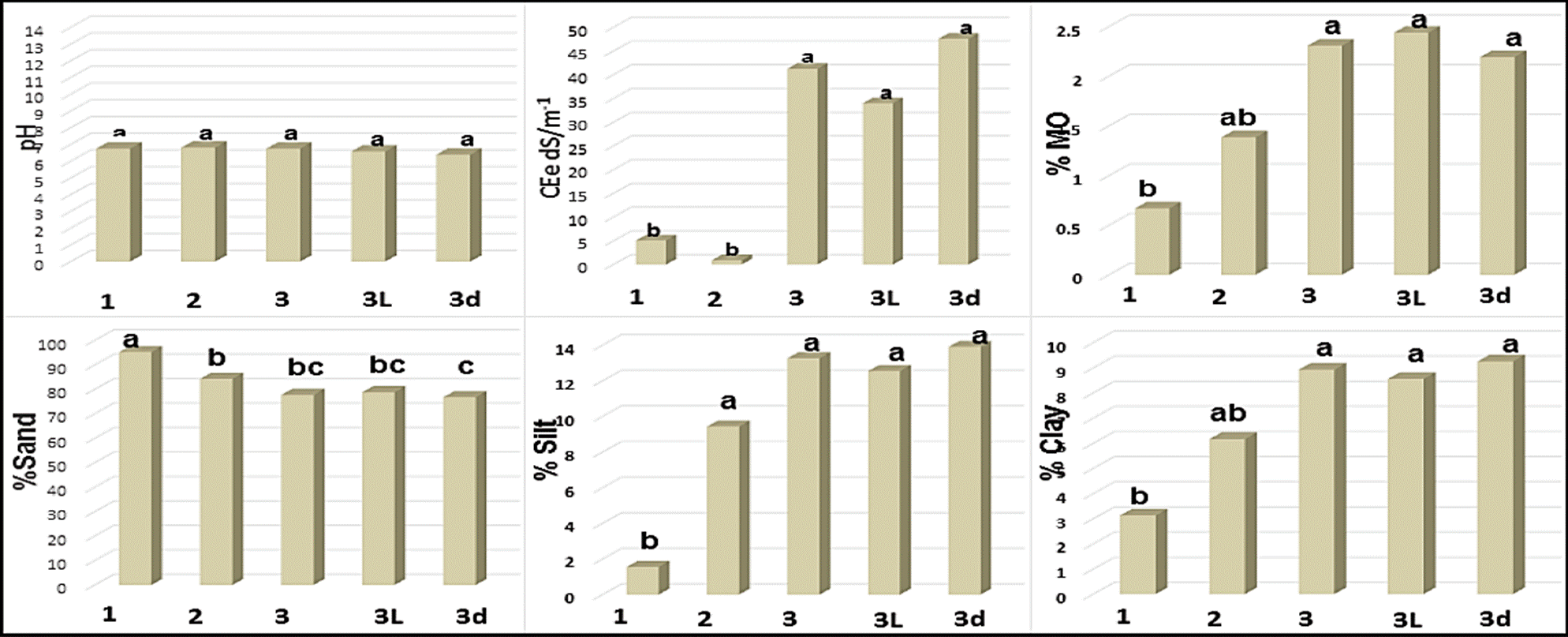
Figure 2 Comparison of means of soil properties in different marshlands geomorphs. The histograms correspond to the average values of soil properties. The letters indicate significant differences between geoforms by the Tukey test (p<0.05). 1 = Beach and coastal dune, 2 = Non flooded high-redge, 3 = Intermediateridge with rainfall seasonal flooding 3L= Most intermediate-ridge with rainfall seasonal flooding and 3d= Depression intermediate-ridge with rainfall seasonal flooding.
Soil pH
There were no significant differences in the values of pH among the studied geoforms (Figure 2), the averages oscillated between 6.4 and 6.8, which corresponded to the neutral values according to the scale by Semarnat (2002).
Electrical conductivity of the saturation extract
The electrical conductivity of the saturation extract (ECe) presented significant differences among the geoforms of the medium ridge with seasonal floods, hill of medium ridge and depression of medium ridge with seasonal floods, with values of 41.27, 47.62, and 34.04 dS m-1 (non-saline or having despicable effects of salinity) and beach and coastal dunes 5.13 dS m-1 (saline soil) with the lowest values (Figure 2).
Organic matter
Statistically significant differences were found in the contents of soil OM among the studied geoforms. The highest values were in medium ridge, hill and depression with seasonal floods (2.31 %), classified as soils with medium organic content, while soils with low organic content were recorded in the geoforms of the beach and coastal dune (0.67 %) and in the nonflooded high ridge, which despite of having 1.39 % on average and of sharing values with both groups, were located in soils with low organic content according to the classification of Semarnat (2002) (Figure 2).
Particle size distribution (PSD)
There were significant differences in the quantity of sand in the studied soils, the highest values or sandy soils were present in beach and costal dunes geoforms (95.30 %), followed by the non-flooded high ridge with sand-frank soil (84.38 %), while the lowest values or sand-frank soils were in the depressions of the medium ridge with seasonal floods (76.83 %). On the contrary, the highest content of clay was in the depressions of the medium ridge with seasonal flood (9.26 %) and the lowest proportion was in the beach, coastal dunes and in the non-flooded ridge (Figure 2).
Variance Components Analysis (VCA)
The values of the variance estimated by means of the REML method for each one of the geoforms were shown in Table 2. In beach and coastal dune geoforms, the maximum verisimilitude did not exist for the components of pH, sand, slime, clay and organic matter, whereas the maximum verisimilitude was observed in the geoforms of medium ridge with seasonal floods and their respective inter-ridges (hill and depression) since the probability was higher on each one of their components due to the fact these soils had medium organic content, highly saline and with a sand-frank texture. Elements expressed as percentages were accumulated and presented in Figure 3.
Table 2 Components of the variance of soil properties in the different geoforms, estimated with REML limited to be non-negative
| Geoforms | pH | CEe | Sand | Silt | Clay | M. O. |
| Beach | 0.02 | 20.91 | 0.67 | 0.00 | 0.67 | 0.02 |
| Non Flooded high-ridge | 0.12 | 1.42 | 71.77 | 33.34 | 11.67 | 0.61 |
| Intermediate-ridge with rainfall seasonal flooding | 0.31 | 489.80 | 63.54 | 23.27 | 21.58 | 1.88 |
| Most Intermediate-ridge with rainfall seasonal flooding | 0.40 | 319.43 | 67.69 | 24.85 | 22.15 | 2.64 |
| Depression intermediate-ridge with rainfall seasonal flooding | 0.23 | 545.64 | 60.62 | 21.61 | 22.21 | 1.30 |
REML= The maximum likelihood restricted method

Figure 3 Ionic concentration in g kg-1 of geoforms with lower values, beach and coastal dunes (1) and Non flooded high-redge (2) and the highest values, Intermediate-ridge with rainfall seasonal flooding (3), most (3L) and Depression intermediate-ridge with rainfall seasonal flooding (3d).
Results of the ionic concentration of each one of the geoforms were presented below:
Distribution of ions in the geoforms
The ionic distribution in soils was identified for each one of the studied geoforms, the anion that remained dominant is Na+ and the dominant cation was Cl-, NaCl salt was formed during the evaporation process. This type of salt was created due to the influence of sea water that is introduced in the coastal zones caused by the movement of tides (Figure 3).
In the non-flooded high ridge, the lowest value of Na+ was 0.227 g kg-1, with an average of 0.83 Na+ g kg-1; followed by beach and coastal dunes geoforms with 4.66 g kg-1, the medium ridges, hills and depressions with seasonal floods presented 11.55, 11.95 and 11.21 g kg-1, respectively (Figure 3). The highest value was located in the depression of medium ridge with seasonal floods with 30.73 k kg-1 of Na+, the cation with lower presence was K+ with 0.041 g kg-1.
Regarding anions, Cl- dominated on each one of the described geoforms. The lowest values were present in the non-flooded high ridge with an average of 1.46 Cl- g kg1, followed by the beach and coastal dune with 8.20 g kg-1 (Figure 3), the highest average values were registered in medium ridges, hills and depressions with seasonal floods geoforms with 27.8, 26.92 y 28.58 g kg-1, respectively (Figure 3), the depression of medium ridge with seasonal floods resulted being the one with the highest salinity (64.47 g kg-1).
The second most important anion was SO4 2- in all geoforms, with an average of 1.60 g kg-1. It is important to mention that carbonates were not found in none of the analyzed geoforms, the presence of bicarbonates was almost null, with an average value of 0.10 g kg-1.
Discussion
This work provided more details on the geoforms established in this work compared with previous reports (Bojórquez et al., 2008; Valdéz et al., 2011). Salinity values found among the geoforms coincided with the ones recorded by Yamnova et al., (2010), for the low lands of the Delta Volga River in Russia, where the highest degree was found in the depression with crusty Solonchaks and the lowest values in the reliefs of low valleys and low hills. Similar results were found by Chambers et al., (2013), which reported the highest levels of salinity in the geoforms with greater influence of tides (marshlands and brackish water). For national marshlands Bojórquez et al., (2008) reported the highest values of ECe between the range of 12.6 to 42.2 dS/m-1 in a sodium Solonchak-type soil of the geoform of plains with flooding by tides, while in parallel ridges, beach and coastal dunes had the lowest values. On the other hand, they differed from Yu et al., (2014), in its study of salinity among the geoforms of the Delta Yellow River in China, since no significant differences were found among the geoforms of the fluvial high plateaus, plains, drainage basin of low lands, tidal plains, marshlands and low plains.
The values of OM found in the different geoforms in the zone of study corresponded to that reported by Chambers et al., (2013) in inter-tidal wetlands from Florida, where the highest values were recorded in geoforms with influence of tidal waters and the lowest ones in the geoform with brackish water; similarly, it coincided with that reported by Valdés et al., (2011) in national marshlands with the highest values of OM and soil organic carbon in the geoforms of islands and islet, followed by the geoform of basins and shores, while in the non-flooded ridges, the contents were lower. Higher values of organic matter than the ones reported by Bojórquez et al., (2006 and 2008) were recorded, with 1.6 % in the plain with tidal flood and 0.52 % in the non-flooded high ridges.
On the other hand, the results of particle size distribution coincided with Roslan et al., (2010) who found that in the crusts and depressions geoforms, percentages of sand and clay were found to be higher than 95 % and lower than 5 %, respectively. Yamnova et al., (2010), mentioned that this type of soils was predominated by sands. In this coastal system, Bojórquez et al., (2008) reported data of an endosal gleyic Solonchacks type soil in the geoform of depression and of arenosols of the non-flooded high ridge, recording the highest content of clay in the depressions and the highest content of sand in the tallest geoforms, which coincided with the results found in this study.
In the geoforms with higher altitude, beach, coastal dunes and non-flooded high ridge, the lowest ionic concentration was found, measured in g kg-1. While in the lowest ones like medium ridge and its inter-ridges with seasonal floods, the highest values were recorded in g kg-1. In all geoforms, the predominating ions were sodium and chlorine, which coincided with that reported by Yamnova et al. (2010).
Conclusion
The most elevated values of salinity, organic matter and clay, were recorded in the geoforms with lower altitude because of the influence of tidal floods and rains, while the geoforms with higher altitude like the non-flooded high ridge presented the highest values of sand and the lowest ones of clay, organic matter and salinity. Likewise, the highest ionic concentration occured in the geoforms with lower altitude (medium ridge, hill and depressions with tidal floods), while the lowest concentration was located in the tallest and sandiest geoforms (non-flooded high ridge).

