SciELO - Scientific Electronic Library Online

 
vol.10 número2First contribution to the description of reproductive structures of Nelsonia goldmani (Rodentia: Cricetidae)Molecular evidence for the presence of Leptospira borgpetersenii in synanthropic rodents in the Nautla region, Veracruz, México índice de autoresíndice de assuntospesquisa de artigos
Home Pagelista alfabética de periódicos  

Serviços Personalizados

Journal

Artigo

Indicadores

Links relacionados

  • Não possue artigos similaresSimilares em SciELO

Compartilhar


Therya

versão On-line ISSN 2007-3364

Therya vol.10 no.2 La Paz Mai./Ago. 2019

https://doi.org/10.12933/therya-19-756 

Articles

Northernmost distribution of the Andean bear (Tremarctos ornatus) in South America, and fragmentation of its associated Andean forest and Paramo ecosystems

Daniel Rodríguez1 

Adriana Reyes1 

Nicolás Reyes-Amaya1  2  * 

Silvana Gallegos-Sánchez3 

Jorge Gutiérrez1  4 

Raúl Suárez4 

Fernando Prieto5 

1 Fundación para la Investigación, Conservación y Protección del Oso Andino (Fundación Wii). Calle 161 25C-30, Bogotá 110911. Colombia. Email: danielosito85@hotmail.com (DR), shisdre@hotmail.com (AR), jegumo@gmail.com (JG).

2 Consejo Nacional de Investigaciones Científicas y Técnicas - Unidad Ejecutora Lillo (CONICET-UEL). Miguel Lillo 251, San Miguel de Tucumán 4000. Argentina. Email: nrreyesa@unal.edu.co (NRA).

3 Carrera de Biología, Facultad de Ciencias Biológicas, Universidad Central de Ecuador, Quito, Ecuador (UCE). Calle Iquique 14-121, Quito 170136. Ecuador. Email: yantana.sags@gmail.com (SGS).

4 Corporación Autónoma Regional del Cesar (CORPOCESAR). Carrera 9A 9-88, Valledupar 200001. Colombia. Email: raulsuarez@corpocesar.gov.co (RS).

5 Corporación Autónoma Regional de la Guajira (CORPOGUAJIRA). Carrera 9A 9-88, Valledupar 200001. Colombia. Email: f.prieto2@gmail.com (FP).


Abstract:

Current northernmost distribution of the Andean bear (Tremarctos ornatus) is not defined precisely; mentioned to be located “at the Serranía del Perijá” without accurate/confirmed distribution records, and placed by the IUCN at the Serranía de Portuguesa (Venezuela). There is an information gap on the fragmentation of the Andean bear associated ecosystems (Andean forest and Paramo) throughout its distribution in Colombia and Venezuela. The aim of this study is to provide precise knowledge on the current northernmost distribution of the Andean bear in South America at the Serranía del Perijá, besides quantifying spatial trends of the fragmentation of its associated ecosystems at the eastern and western slopes. Confirmed distribution records were obtained from field surveys (2009 to 2016), literature, scientific collections and biodiversity databases. The fragmentation degree of Andean bear associated ecosystems was characterized using FRAGSTATS (V 4.2) software with satellite images from 2008. A current population block with at least three sectors of incidence is present along both slopes of the Serranía del Perijá. Although the Colombian slope comprises greater raw area of Andean bear associated ecosystems, it is highly fragmented and isolated. Core area analysis (extracting a disturbance buffer of 1,000 m into the border of each patch) exhibits a Venezuelan slope maintaining greater amount of Andean bear associated ecosystems at few, large and less fragmented patches. This study extends the distribution of the species 180 km until the north of the Serranía del Perijá (regarding the current distribution recognized by the IUCN) and provides the northernmost confirmed distribution records for South America: Barrancas (Colombia) and Mara (Venezuela) municipalities. This study provides the first fine-scale information on Andean bear associated ecosystems fragmentation for Colombia and Venezuela, with traceable landscape measurements permitting future long-term comparative analyses. A high fragmentation degree of the Andean bear associated ecosystems is present at the Colombian slope of the Serranía del Perijá due to extensive legal and illegal agricultural activities and wood extraction. The lack of information about the Andean bear distribution and its associated ecosystems fragmentation could be putting the survival of local populations at risk, while a clear knowledge on these issues could generate planned conservation actions by the governmental environmental authorities.

Key words: Colombia; ecosystems fragmentation; northernmost distribution; Tremarctos ornatus; Venezuela

Resumen:

La distribución más septentrional actual del oso andino (Tremarctos ornatus) no está definida con precisión; generalmente se le localiza “en la Serranía del Perijá” sin registros precisos/confirmados, y la UICN la ubica en la Serranía de Portuguesa (Venezuela). Existe un vacío de información de la fragmentación de los ecosistemas asociados al oso andino (bosque Andino y Páramo) en Colombia y Venezuela. El objetivo de este estudio es brindar conocimiento preciso sobre la distribución más septentrional del oso andino en Suramérica en la Serranía del Perijá, además de cuantificar las tendencias espaciales de la fragmentación de sus ecosistemas asociados en las vertientes occidental y oriental. Los registros de distribución confirmados se obtuvieron de exploraciones de campo (2009 to 2016), literatura, colecciones científicas y bases de datos de biodiversidad. El grado de fragmentación de los ecosistemas asociados al oso andino se caracterizó utilizando el software FRAGSTATS (V 4.2) con imágenes satelitales del 2008. Un bloque poblacional actual con al menos tres sectores de incidencia está presente en ambas laderas de la Serranía del Perijá. Si bien la vertiente colombiana presenta una mayor área en bruto de los ecosistemas asociados del oso andino, está altamente fragmentada y aislada. Análisis de área de nucleo (extrayendo un área de influencia de perturbación de 1,000 m desde el borde de cada parche) exhiben que la vertiente venezolana contiene una mayor cantidad de ecosistemas asociados al oso en pocos parches, grandes, y menos fragmentados. Este estudio extiende la distribución de la especie 180 km hasta el norte de la Serranía del Perijá (en relación con la distribución actual reconocida por la UICN) y proporciona los registros de distribución mas septentrionales confirmado para Sudamérica: municipio de Barrancas (Colombia) y Mara (Venezuela). Este estudio proporciona la primera información a escala fina sobre la fragmentación de los ecosistemas asociados al oso andino para Colombia y Venezuela, con mediciones espaciales del paisaje monitoreables, permitiendo análisis comparativos a largo plazo. Un alto grado de fragmentación de los ecosistemas asociados al oso andino está presente en la vertiente colombiana de la Serranía del Perijá debido a actividades agrícolas legales e ilegales y extracción de madera. La falta de información sobre la distribución del oso andino y la fragmentación de sus ecosistemas asociados podría poner en riesgo la supervivencia de las poblaciones locales, mientras que un conocimiento claro sobre estos temas podría generar acciones de conservación planificadas por parte de las autoridades ambientales gubernamentales.

Introduction

The Andean bear (Tremarctos ornatus) is the only extant Ursid in South America (Peyton 1999), and categorized as Vulnerable (VU) to extinction by the International Union for the Conservation of Nature (IUCN) due to increasing threats such as habitat loss (deforestation and extension of agricultural activities), and illegal hunting of specimens as retaliation because human-bear conflicts (Velez-Liendo and García-Rangel 2017). The distribution of the Andean bear is strongly associated to the Andean mountain range, in discontinuous population blocks (Kattan et al. 2004) located from the Republic of Colombia and the Bolivarian Republic of Venezuela (Rodríguez et al. 2003; García-Rangel 2012) at the north, to the Plurinational State of Bolivia and the Republic of Argentina (Del Moral and Lameda 2011; Teta et al. 2018) at the south.

The northern distribution of the Andean bear in South America has been reported to extend until the Serranía de Portuguesa at Sierra de Mérida along the north-eastern Venezuelan territory (Yerena et al. 2007), and the Serranía del Perijá along the northern Colombian and Venezuelan geographic limits (Rodríguez and Lozada 1989; Peyton 1999; Rodríguez et al. 2003; Corredor-Carrillo and Muñoz-Saba 2007; Yerena et al. 2007; Solari et al. 2013). However, the current northernmost distribution of the Andean bear in South America has not been defined precisely; most authors have suggested this northernmost distribution as being located “at the Serranía del Perijá”, without accurate and confirmed distribution records along this mountain range (Rodríguez and Lozada 1989; Peyton 1999; Rodríguez et al. 2003; Corredor-Carrillo and Muñoz-Saba 2007; Yerena et al. 2007; Solari et al. 2013). The IUCN reports the current northernmost distribution of this species at the Venezuelan Serranía de Portuguesa (north-eastern portion of the Sierra de Mérida; Velez-Liendo and García-Rangel 2017). Although Mondolfi (1989) and Viloria et al. (1995) provided some confirmed distribution records of the Andean bear for the eastern slope of the Serranía del Perjá at Venezuela, these records corresponds to the 50’s, 70’s and 90’s decades.

The lack of information about the Andean bear distribution could be putting the survival of local populations at risk (García-Rangel 2012). Additionally, there is a knowledge gap about the fragmentation of Andean bear associated ecosystems (Andean forest and Paramo) along its Colombian and Venezuelan distribution. In this sense, the aim of this study is to provide precise knowledge on the current northernmost distribution of the Andean bear in South America at the Colombian and Venezuelan Serranía del Perijá, and quantify spatial trends of fragmentation processes of the Andean bear associated ecosystems at the western (Colombia) and eastern (Venezuela) slopes of this mountain range. This constitute a contribution to the knowledge of the species and its associated ecosystems, for the elaboration of future habitat monitoring initiatives and accurately planned conservation actions headed by the environmental authorities (governmental institutions) at their respective local jurisdictions.

Methods

During the years 2009-2016, 15 field surveys were carried out in the Colombian municipalities of Becerril, Chimichagua, Codazzi, Curumaní, La Jagua de Ibirico, La Paz, Manaure, San Alberto (department of Cesar), Barrancas, El Molino, La Jagua del Pilar, Urumita, and Villanueva (department of La Guajira; Figure 1). Additionally, involuntary incursions to the Bolivarian Republic of Venezuela was made during field surveys searching Andean bear traces (see Appendix 1).

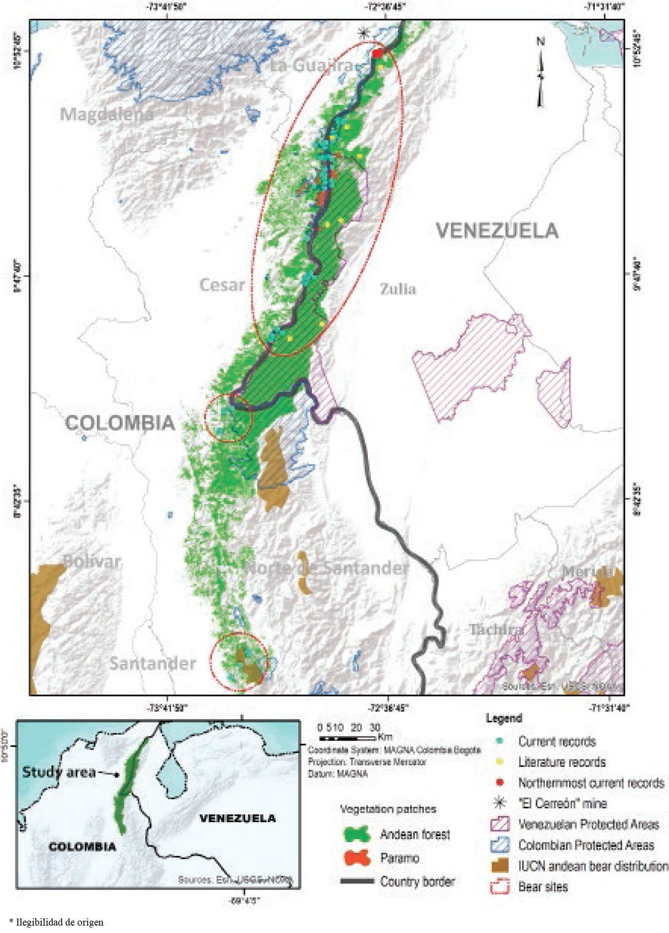
Figure 1 Confirmed presence records of the Andean bear (Tremarctos ornatus) obtained during the field surveys made for this study, and within the revised literature, including the northernmost distribution records for the species at South America. 

In order to obtain accurate and confirmed distribution records of the Andean bear in northern Colombia along the Serranía del Perijá, the zones with recent information of possible presence of the Andean bear (based on the information from the local communities) were visited at each sampled municipality. The presence of the species was verified through the search of bear traces during field surveys in Andean forest and Paramo ecosystems (e. g., foot prints, tracks, bark of trees marked with scratches, feeding traces, feces, direct observations), and occasionally installing camera traps (just for the municipalities of Manaure and La Paz, department of Cesar). Additionally, we performed a revision of online information about presence records of the species (e. g., voucher specimens, camera trap images, direct observations and indirect traces of presence) from scientific literature, scientific collections (Alberto Cadena García Mammal Collection of the Instituto de Ciencias Naturales, ICN; Mammal Collection of the Instituto Alexander von Humboldt, IAvH) and Biodiversity databases (Global Biodiversity Information Facility, GBIF; Mammal Networked Information System, MaNIS; System of Information on Biodiversity of Colombia, SIB). The distribution records obtained through the different sampling methods were organized at Appendix 1, including information on locality, geographical coordinates and type of record (Appendix 1), also being displayed on a map (Figure 1).

A characterization of the fragmentation degree of Andean bear associated ecosystems (Andean forest and Paramo) at the Colombian (western) and Venezuelan (eastern) slopes of the Serranía del Perijá was performed through the analysis of satellite images from 2008 (TERRA ASTER satellite: 3A1-70, 3A1-71, 3A1-72, 3A1-73, 3A1-74; SPOT satellite: 645-330, 646-329, 56463290503141521431A, 2A/203045101). The satellite images were interpreted using ArcMap software (v10.1; ESRI, Redlands, CA, USA), taking into account land coverages over 500 m of elevation to generate a landscape coverage map (scale 1:100,000). Three landscape coverage classes were established: Andean forest (comprising natural Andean forest coverages, considered as natural habitat of the Andean bear), Paramo (comprising natural highland shrubs and grass coverages, considered as natural habitat of the Andean bear), and transformed coverages (comprising anthropogenic or anthropogenic-natural mixed landscape coverages such as pasturelands, croplands and urban areas, not considered as natural habitat of the Andean bear). A raster image (250 m resolution) was extracted from the landscape coverage map and analyzed with FRAGSTATS software (v4.2; McGarigal et al. 2012). Twelve metrics at landscape (overall landscape configuration), class (specific landscape coverages configuration) and patch (individual patch configuration, including a core area analysis extracting a disturbance buffer of 1,000 m into the border/edge of each patch) levels were calculated (for detailed descriptions of metrics see Table 1), quantifying the fragmentation spatial trends for the Andean bear associated ecosystems at the western (Colombia) and eastern (Venezuela) slopes of the Serranía del Perijá (Table 1). Taking into account the current knowledge of home ranges for female (1,477 ha) and male (5,908 ha) Andean bears (Castellanos 2011), individual patches were also categorized per area interval as small (1 ha < patch ≤ 1,500 ha), medium (1,500 ha < patch ≤ 6,000 ha) and large (patch > 6,000 ha) patches. The Andean bear associated ecosystems fragments (patches) were displayed on a map (Figure 1). Although Andean bears do not recognize political geographic limits at its natural movements across associated ecosystems, we focused the fragmentation analysis at a bi-national (Colombia and Venezuela) scale, as a contribution to future management efforts headed by environmental authorities (governmental institutions) of both countries at their respective local jurisdictions.

Table 1 Metrics quantifying spatial trends of Andean bear associated ecosystems fragmentation degree for the year 2008 at the Colombian (western) and Venezuelan (eastern) slopes of the Serranía del Perijá. 

Value
Metrics level Metric Description Category Colombia Venezuela
Landscape level Shannon’s Diversity Index (SHDI) Increases as the number of different patch classes increases (patch richness). Equals “0” when the landscape contains only 1 patch of a particular class of landscape coverage (no diversity). Landscape 0.78 0.48
Simpson’s diversity index (SIDI) Increases (approaching 1) as the number of different patch types (patch richness) increases. Equals “0” when the landscape contains only 1 patch of a particular class of landscape coverage (no diversity). Landscape 0.52 0.25
Class level Total class area (CA) It is the total area of a particular class of landscape coverage. Approaches “0” when a class of landscape coverage becomes rare in the landscape. Measured as hectares (ha). Forest 42,6094 ha 313,244 ha
Paramo 15,931 ha 7,394 ha
Percentage of landscape (PLAND) It is the percentage of the total area of the entire landscape comprised by a particular class of landscape coverage. Approaches “0” when a class of landscape coverage becomes rare in the landscape. Measured as percentage (%). Forest 47.56 % 85.37 %
Paramo 1.78 % 2.01 %
Total core area (TCA) It is the total core area of a particular class of landscape coverage. Approaches “0” when a class of landscape coverage becomes rare in the landscape. Measured as hectares (ha). Forest 71,462 ha 219,350 ha
Paramo 1,131 ha 56 ha
Core percentage of landscape (CPLAND) It is the percentage of the total area of the entire landscape comprised by a particular class of landscape coverage. Approaches “0” when a class of landscape coverage becomes rare in the landscape. Measured as percentage (%). Forest 7.98 % 59.78 %
Paramo 0.13 % 0.02 %
Number of patches (NP) It is the number of patches of a particular class of landscape coverage. Equals “1” when a class of landscape coverage contains only 1 patch. Forest 336 19
Paramo 18 15
Mean patch size (AREA_MN) It is the mean size of patches of a class of landscape coverage. Approaches “0” when a class of landscape coverage becomes rare in the landscape. Measured as hectares (ha). Forest 628 ha 7,119 ha
Paramo 1,225 ha 528 ha
Edge density (ED) Increases as the number of patches of a class of landscape coverage increases, increasing more when patches are smaller (greater contact edge per patch). Equals “0” when a class of landscape coverage contains only 1 patch. Measured as meters per hectare (m/ha). Forest 13.48 m/ha 3.13 m/ha
Paramo 0.63 m/ha 0.45 m/ha
Mean shape index (SHAPE_MN) Increases as mean patch shape of a class of landscape coverage becomes more irregular. Equals “1” (minimum value) when patch shape is circular or squared (not irregular shape). Forest 1.63 1.59
Paramo 2.24 1.91
Mean euclidean nearest neighbor distance (ENN_MN) It is the mean distance between nearest patches of a class of landscape coverage. Approaches “0” when the distance between nearest neighbor patches decreases. Measured as meters (m). Forest 650.86 m 520.75 m
Paramo 888.37 m 1,174.04 m
Patch level Absolute number of patches (and its area, ha) per area interval It is the number of patches of andean bear associated ecosystems (and the area comprised by them) within a particular area interval Small (1 < patch ≤ 1,500 ha) 667 (57,562 ha) 53 (7,256 ha)
Medium (1,500 ha < patch ≤ 6,000 ha) 13 (35,693 ha) 3 (7,631 ha)
Large (patch > 6,000 ha) 11 (348,768 ha) 2 (305,750 ha)
Absolute number of patches (and its area, ha) per core area interval It is the number of patches of andean bear associated ecosystems (and the core area comprised by them) within a particular core area interval Small (1 < patch ≤ 1,500 ha) 17 (4,512.5 ha) 4 (200 ha)
Medium (1,500 ha < patch ≤ 6,000 ha) 2 (5,493 ha) 0 (0 ha)
Large (patch > 6,000 ha) 1 (62,587 ha) 2 (219,206 ha)

Results

From the field surveys, 97 confirmed presence records of the Andean bear was found along the Serranía del Perijá at the municipalities of Becerril, Chimichagua, Codazzi, Curumaní, La Jagua de Ibirico, La Paz, Manaure, San Alberto (department of Cesar), Barrancas, El Molino, La Jagua del Pilar, Urumita and Villanueva (department of La Guajira) for the western slope of the Serranía del Perijá at Colombia, and at the municipalities of Mara, Jesús Enrique Lozada, Rosario de Perijá and Machiques de Perijá (state of Zulia) for the eastern slope of the Serranía del Perijá at Venezuela (involuntary incursions to the Bolivarian Republic of Venezuela during field surveys while searching Andean bear traces). Literature review provided eight presence records of the Andean bear at the municipalities of Mara, Jesús Enrique Lozada, Machiques del Perijá and Rosario del Perijá (state of Zulia) for the eastern slope of the Serranía del Perijá at Venezuelan (Mondolfi 1989; Viloria et al. 1995; Appendix 1), and did not yield results for the western slope of the Serranía del Perijá at Colombia. The revision of online records coming from scientific collections and biodiversity databases did not yield results for presence records of the Andean bear at the north of Colombia and Venezuela along the Serranía del Perijá.

We report the current northernmost distribution records of the Andean bear in South America for the locality Monte Fresco at the western slope of northern Serranía del Perijá in Colombia (municipality of Barrancas, department of La Guajira), and the adjacent eastern slope of northern Serranía del Perijá in Venezuela (municipality of Mara, state of Zulia; Figure 1; Appendix 1). These northernmost records corresponded to recent scratches on trees of Nigüito (Miconia sp.), Aguacatillo (Persea sp.), Pringamoza (Urera baccifera), Guamo (Inga sp.) and feces on natural bear trails into the Andean forest, as well as direct observations of an individual feeding on corn and plantain crops (Appendix 1).

The results of the characterization of the spatial trends of fragmentation degree of the Andean bear associated ecosystems (Andean forest and Paramo) along the Serranía del Perijá are summarized in Table 1. The Colombian slope possess a much greater fragmentation degree regarding the Venezuelan one, represented by greater patches diversity index values (SHDI: 0.78 Colombia vs 0.48 Venezuela; SIDI: 0.52 vs 0.25) at the landscape level analyses (Table 1), a greater number of patches (NP: 336 vs 19; class level analysis), smaller size of patches (AREA_MN: 628.46 ha vs 7,119.18 ha) and bigger isolation between patches (ENN_MN: 650.86 m vs 520.75 m) for the Andean forest (the dominant landscape coverage for both slopes in terms of surface and patch occurrence, Table 1), as well as greater edge amount for the Andean forest (ED: 13.48 m/ha vs 3.13 m/ha) and Paramo (ED: 0.63 m/ha vs 0.45 m/ha), and a greater irregular shape of patches for the Andean forest (SHAPE_MN: 1.63 vs 1.59) and Paramo (SHAPE_MN: 2.24 vs 1.91), at the class level analyses (Table 1).

In terms of patch level analyses, when core area analyses were performed (extracting a disturbance buffer of 1,000 m into the border/edge of each patch, Table 1), for the Colombian slope of the Serranía del Perijá, the total area comprised by small (1 ha < patch ≤ 1,500 ha), medium (1,500 ha < patch ≤ 6,000 ha) and large (patch > 6,000 ha) patches of Andean bear associated ecosystems is reduced from 57,562.5 ha to 4,512.5 ha (small patches), 35,693.75 ha to 5,493.75 ha (medium), and 348,768.75 ha to 62,587.5 ha (large patches; Table 1). On the other hand, for the Venezuelan slope of the Serranía del Perijá, those reductions were from 7,256.25 ha to 200 ha (small patches), 7,631.25 ha to “0” (medium), and 305,750.01 ha to 219,206.25 ha (large patches; Table 1).

Discussion and conclusions

The presence records of the Andean bear obtained during the field surveys made for this study and from the revised literature, reveals at least three distinguishable sectors with bears presence along the eastern (Venezuela) and western (Colombia) slopes of the Serranía del Perijá (Figure 1; Appendix 1). The first sector corresponds to the southernmost portion of the Serranía del Perijá at the municipality of San Alberto (department of Cesar) at Colombia, coinciding with the only Andean bear distribution currently recognized by the IUCN for the Serranía del Perijá (Velez-Liendo and García-Rangel 2017; Figure 1). The second sector corresponds to the center of the Serranía del Perijá, and includes the municipalities of Chimichagua and Curumaní (department of Cesar) at Colombia, which is most probably connected with the Andean bear distribution block recognized by the IUCN for the Colombian National Natural Park Catatumbo Barí in the department of Norte de Santander (adjacent, but not belonging to the Serranía del Perijá; Velez-Liendo and García-Rangel 2017; Figure 1). The third sector correspond to the north of the Serranía del Perijá and includes the municipalities of La Jagua de Ibirico, Becerril, Codazzi, La Paz, Manaure (department of Cesar), La Jagua del Pilar, Urumita, Villanueva, El Molino and Barrancas (department of La Guajira) at Colombia, and the municipalities of Mara, Jesús Enrique Lozada, Rosario de Perijá and Machiques de Perijá (state of Zulia) at Venezuela (Figure 1). Although there is abundant information from local communities on the presence of the species at other municipalities from the western slope of the Serranía del Perijá at Colombia, that could complement the distribution information for the species at the south (Municipalities of Abrego, San Martín and Cachira at the department of Norte de Santander), middle (El Carmen Municipality at the department of Norte de Santander, and the municipalities of Chiriguaná, La Gloria, Pelaya and Pailitas at the department of Cesar) and north (municipalities of San Juan del Cesar and Fonseca at the department of La Guajira) of the Colombian Serranía del Perijá (Torres 2008; Rodríguez and Reyes 2009; Rodríguez et al. 2010; Rodríguez et al. 2011), those areas were not sampled for this study.

These results exhibit a current Andean bear population block located along the eastern (Venezuela) and western (Colombia) slopes of the Serranía del Perijá (Appendix 1; Figure 1), previously suggested as the “Perijá population nucleus” by Rodríguez and Lozada (1989). The current geographical distribution recognized by the IUCN for the Andean bear in South America states that its northernmost limit is reached at the Venezuelan Serranía de Portuguesa (Sierra de Mérida, north-eastern Venezuela; Velez-Liendo and García-Rangel 2017; Figure 1), including just the suthernmost portion of the Serranía del Perijá in the distribution range of this species, and dismissing previous distributions mentioned by Mondolfi (1989), Rodríguez and Lozada (1989), Viloria et al. (1995), Peyton (1999), Rodríguez et al. (2003), Corredor-Carrillo and Muñoz-Saba (2007), Yerena et al. (2007), and Solari et al. (2013), that suggested the northern presence of the Andean bear as reaching at least the middle portion of the Serranía del Perijá. Thus, the presence records provided at this study extend the distribution of the species 180 km at the north of Colombia and Venezuela until the north of the Serranía del Perijá regarding the current distribution recognized by the IUCN (Velez-Liendo and García-Rangel 2017; Figure 1), provide confirmed records that supports previously suggested distributions of the Andean bear along the Serranía del Perijá (Rodríguez and Lozada 1989; Peyton 1999; Rodríguez et al. 2003; Corredor-Carrillo and Muñoz-Saba 2007; Yerena et al. 2007; Solari et al. 2013), update previous records reported for the Venezuelan (eastern) slope of the Serranía del Perijá (Mondolfi 1989; Viloria et al. 1995), and elucidate a more accurate northernmost distribution limit for this species in South America at Colombia and Venezuela. These findings locate the northernmost distribution range limit of the Andean bear at the municipality of Barrancas (locality Monte Fresco, department of La Guajira) in Colombia, and the municipality of Mara (state of Zulia) in Venezuela (Figure 1; Appendix 1). These northernmost records also confirm that feeding traces on plantain bushes include not just fruit consumption, but also buds consumption, in agreement with popular information previously collected (Rodríguez and Reyes 2009, Rodríguez et al. 2010).

Although there is some general information about Andean bear distribution range fragmentation and habitat availability for the northern Andes (Venezuela, Colombia and Ecuador; Kattan et al. 2004), this information focuses at a large scale analysis of potential distribution discontinuity for the species, with landscape coverage information from 1994 for some sectors and from 2000 for others. Although the characterization of the spatial trends of fragmentation degree of the Andean bear associated ecosystems (Andean forest and Paramo) along the Serranía del Perijá made for this study used satellite images from 2008 (and fragmentation trends could have slightly changed), this study provides the first fine-scale information on Andean bear associated ecosystems fragmentation for Colombia and Venezuela, with traceable landscape measurements permitting long-term comparative analyses in the future (Table 1). These analyses exhibit that the Colombian (western) and Venezuelan (eastern) slopes differ in patch number, size, shape, edge and isolation between parches, so that the Colombian slope possess a much greater fragmentation degree regarding the Venezuelan one (Table 1).

Although the Colombian slope of the Serranía del Perijá comprise a bigger raw area of Andean bear associated ecosystems (442,025 ha vs 320,638 ha), the Venezuelan slope comprise much less fragmented ones (Table 1), so that the Andean bear associated ecosystems resulting from core area analyses exhibit much more extension (area) for the Venezuelan slope (219,406.25 ha) than the Colombian one (72,593.75 ha; Table 1). This phenomenon is related to the high quantity of small and irregularly shaped patches present at the Colombian slope of the Serranía del Perijá (that disappear at the core area analyses) (Figure 1); smaller patches with greater shape complexity have less internal area, which constitutes less habitat availability and greater edge effect (McGarigal et al. 2012). In the case of the Colombian slope of the Serranía del Perijá, the loss of natural landscape coverage is a result of extensive agricultural activities for legal (food production for self-maintenance or trade) and illegal (crops to produce illegal drugs) purposes, as well as wood extraction to generate grazing pastures (livestock) or build houses (Torres 2008; Rodríguez and Reyes 2009; Rodríguez et al. 2010; Rodríguez et al. 2011). In this sense, Kattan et al. (2004) previously mentioned that large habitat blocks encompassing a continuous elevational gradient remain in the Venezuelan (eastern) slope of the Serranía de Perijá.

The Andean bear associated ecosystem Paramo is scarcely represented along the Serranía del Perijá, constituting 1.78 % of the landscape in the Colombian slope, and 2.01 % in the Venezuelan slope of this mountain range (PLAN; Table 1). Due to its natural distribution at Andean mountain peaks separated between them by large distances (Cuatrecasas 1958), this ecosystem is intrinsically fragmented (Jiménez-Rivillas et al. 2018). When Paramo is present, Andean bear uses it, but it does not constitute its main habitat (Rodríguez 1991; Ríos-Uzeda et al. 2006), a fact supported by the small amount of Paramo ecosystem comprised by the distribution of the persistent Andean bear population block of Perijá (Mondolfi 1989; Viloria et al. 1995; Appendix 1). In this sense, many authors have previously indicated the preference of the Andean bears to use the Andean forest rather than the Paramo ecosystem (Walker 1964; Borrero 1967; Knight 1967; Mondolfi 1971; Peyton 1980; Yerena 1987; Rodríguez 1991; Ríos-Uzeda et al. 2006).

The elongated shape of Andean bear distribution range and patterns of anthropic land use in the northern Andes make the distribution range of this species particularly prone to fragmentation (Kattan et al. 2004). Taking into account the high degree of fragmentation for the Andean bear associated ecosystems at the Colombian slope of the Serranía del Perijá (Table 1), presumably when bears belonging to the Perijá population block transit between the two slopes of the Serranía del Perijá, they pass from the Venezuelan (eastern) slope with mature and relative continuous forests, to the Colombian (western) slope where the continuity of the forest is broken due to intensive and extended human activities and the ecological integrity is very compromised (Figure 1; Table 1). Those intensive and extended human activities at the Colombian slope increases the risk of human-bear conflicts and hunting retaliations from settler communities, as well as subsistence hunting activities by indigenous communities.

The Andean bear is categorized as vulnerable to extinction (VU) at a general scale by the IUCN (Velez-Liendo and García-Rangel 2017), and at Colombia by the Ministerio de Ambiente, Vivienda y Desarrollo Territorial (MADS 2017), also categorized as endangered (EN) by Rodríguez et al. (2015) at Venezuela. There is no information on the population dynamics and conservation threats of the northernmost portion of the Andean bear population block of Perijá at the municipalities of Barrancas (locality Monte Fresco, department of La Guajira) in Colombia and Mara (state of Zulia) in Venezuela (Figure 1; Appendix 1), a concerning matter since this sector of the Serranía del Perijá is subjected to intense wood extraction and hunting activities (Rodríguez et al. 2010), and located just 12 kilometers southeast from the largest open-pit coal mine in Colombia (El Cerrejón; Figure 1).

There are generalized and not confirmed assumptions about the northern distribution of the Andean bear in South America, as the case of the lacking-evidence distribution reported for the species at the Colombian Sierra Nevada de Santa Marta at the departments of Cesar, Magdalena and La Guajira (north-western Colombia; Solari et al. 2013), refuted by Reyes-Amaya (2015), and the wrong assumption of not presence of the species at the Colombian and Venezuelan Serranía del Perijá (Velez-Liendo and García-Rangel 2017; Figure 1) refuted in this study (Figure 1; Appendix 1). Likewise, the absence of fine-scale information on Andean bear associated ecosystems fragmentation for Colombia and Venezuela could represent a major challenge for the conservation of this Ursid. The lack of information about the Andean bear distribution (García-Rangel 2012) and its associated ecosystems fragmentation could be putting the survival of local populations at risk, while a clear knowledge on these issues could generate planned conservation actions for this species by the governmental environmental authorities at their respective local jurisdictions. The absence of information on the conservation state of the northernmost population block of this species at South America (at the Serranía del Perijá) makes it necessary to carry out biological research on its conservation and threats.

Acknowledgments

The authors dedicate this study to the memory of C. R. Ortiz Camargo, a local conservationist of the Andean bear in Santa Bárbara (Santander, Colombia) and a great friend, who has suddenly left us three years ago. The authors thank P. P. Contreras, A. Navarro (Manaure municipality), J. G. Hernandez (La Paz), Mate/A. Pérez, Chacó/G. Pérez (Yukpa indigenous settlement of Sokorpa), and Y. E. Ureche (Barrancas municipality) for its helpful guidance during the field surveys, and two anonymous reviewers for its valuable comments to earlier versions of this manuscript. The present study provides information obtained during the design and execution of the regional action plan for the conservation of the Andean bear in the Serranía del Perijá Ecoregion, funded by the Corporación Autónoma Regional del Cesar (CORPOCESAR) and the Corporación Autónoma Regional de La Guajira (CORPOGUAJIRA).

Literature Cited

Borrero, L. I.. 1967. Mamíferos neotropicales. Universidad del Valle, Departamento de Biología. Cali, Colombia. [ Links ]

Castellanos, A.. 2011. Andean bear home ranges in the Intag region, Ecuador. Ursus 22:65-73. [ Links ]

Corredor-Carrillo, D. A., and Y. Muñoz-Saba. 2007. Mamíferos de la alta montaña de Perijá. Colombia Biodiversidad Biótica V: la alta montaña de la Serranía de Perijá (JO Rangel-Ch., ed.). Universidad Nacional de Colombia, Facultad de Ciencias, Instituto de Ciencias Naturales, Corporación Autónoma Regional del Cesar (CORPOCESAR), Gobernación del Departamento del Cesar. Bogotá, Colombia. [ Links ]

Cuatrecasas, A. J.. 1958. Aspectos de la vegetación natural de Colombia. Revista de la Academia Colombiana de Ciencias Exactas, Físicas y Naturales 10:221-264. [ Links ]

Del Moral, J. F., and F. I. Lameda. 2011. Registros de ocurrencia del oso andino (Tremarctos ornatus Cuvier, 1825) en sus límites de su distribución nororiental y austral. Revista Museo Argentino de Ciencias Naturales 13:7-19. [ Links ]

García-Rangel, S.. 2012. Andean bear Tremarctos ornatus natural history and conservation. Mammal Review 42:85-119. [ Links ]

Jiménez-Rivillas, C., J. J. García, M. A. Quijano-Abril, J. M. Daza, and J. J. Morrone. 2018. A new biogeographical regionalisation of the Páramo biogeographic province. Australian Systematic Botany 31:296-310. [ Links ]

Kattan, G., O. L. Hernández, I. Goldstein, V. Rojas, O. Murillo, C. Gómez, H. Restrepo, and F. Cuesta. 2004. Range fragmentation of the spectacled bear Tremarctos ornatus in the northern Andes. Oryx 38:1-10. [ Links ]

Knight, R. L.. 1967. Biology of the Spectacled Bear (Tremarctos ornatus) (Cuvier, 1825). Wildlife Science Group, College of Fisheries, University of Washington. Seattle, U. S. A. [ Links ]

McGarigal, K., S. A. Cushman, and E. Ene. 2012. FRAGSTATS v4: Spatial Pattern Analysis Program for Categorical and Continuous Maps. University of Massachusetts Amherst. Massachusetts, U. S. A. [ Links ]

Ministerio de Ambiente y Desarrollo Sostenible. 2017. Resolución 1912, Por la cual se establece el listado de las especies silvestres amenazadas de la diversidad biológica colombiana continental y marino costera que se encuentran en el territorio nacional, y se dictan otras disposiciones. Ministerio de Ambiente y Desarrollo Sostenible. Colombia. September 17, 2017. [ Links ]

Mondolfi, E.. 1971. Mamíferos Suramericanos en peligro de extinción. El oso frontino (Tremarctos ornatus). Revista Defensa de la Naturaleza 1:31-35. [ Links ]

Mondolfi, E.. 1989. Notes on the distribution, habitat, food habits, status and conservation of the Spectacled bear (Tremarctos ornatus Cuvier) in Venezuela. Mammalia 53: 525-544. [ Links ]

Peyton, B.. 1980. Ecology, distribution and Food Habits of the Spectacled Bears, Tremarctos ornatus, in Peru. Journal of Mammalogy 6:639-652. [ Links ]

Peyton, B.. 1999. Spectacled bear conservation action plan. Pp 57-198 in Bears, status survey and conservation action plan (Servheen, C. S., S. Herrero, and B. Peyton, eds.). IUCN/SSC Bear and polar bear specialist group. Gland, Switzerland. [ Links ]

Reyes-Amaya, N.. 2015. Familia Ursidae. Pp 164-171 in Los carnívoros terrestres y semiacuáticos continentales de Colombia (Suárez-Castro, A. F., and H. E. Ramírez-Cháves, eds.). Universidad Nacional de Colombia. Bogotá, Colombia. [ Links ]

Ríos-Uzeda, B., H. Gómez, and R. B. Wallace. 2006. Habitat preferences of the Andean bear (Tremarctos ornatus) in the Bolivian Andes. Journal of Zoology 268:271-278. [ Links ]

Rodríguez, D., and R. Lozada. 1989. Distribución y estado actual de las poblaciones de oso en Colombia. Reporte nacional. XI Congreso Latinoamericano de Zoología. Cartagena, Colombia. [ Links ]

Rodríguez, D.. 1991. Reconocimiento del hábitat natural del oso andino, Tremarctos ornatus, en el Parque Nacional Natural las Orquídeas, Antioquia, Colombia. Tesis de grado. Universidad Nacional de Colombia. Bogotá, Colombia. [ Links ]

Rodríguez, D., F. Cuesta, I. Goldstein, L. Naranjo, and O. Hernández. 2003. Estrategia ecorregional para la conservación del oso andino Tremarctos ornatus en los Andes del norte. WWF, Fundación Wii, Ecociencia, Wildlife Conservation Society. Bogotá, Colombia. [ Links ]

Rodríguez, D., and S. A. Reyes. 2009. Plan de acción regional para la conservación del oso andino (Tremarctos ornatus) en la Ecorregión Serranía del Perijá, jurisdicción de la Corporación Autónoma Regional del Cesar -CORPOCESAR-, en el marco del Programa Nacional de Conservación del oso andino en Colombia. Corporación Autónoma Regional del Cesar (CORPOCESAR). Valledupar, Colombia. [ Links ]

Rodríguez, D., S. A. Reyes, M. Muñoz, and M. J. Mendoza. 2010. Aunar esfuerzos para establecer un programa de monitoreo para el seguimiento de cóndores en la Serranía del Perijá y en la Sierra Nevada de Santa Marta, y la definición de la distribución y residencia de la población de osos en la Serranía del Perijá en el departamento de La Guajira. Corporación Autónoma Regional de la Guajira (CORPOGUAJIRA). Riohacha, Colombia. [ Links ]

Rodríguez, D., S. A. Reyes, M. Muñoz, M. Rincón, L. I. Medina, L. L. Medina, M. A. Galindo, L. Camacho, and P. Contreras. 2011. Implementación del plan de acción regional para la conservación del oso andino (Tremarctos ornatus) en la eco región Serranía del Perijá en el departamento del Cesar, en el marco del Programa Nacional de Conservación del oso andino. Corporación Autónoma Regional del Cesar (CORPOCESAR). Valledupar, Colombia. [ Links ]

Rodríguez, J. P., A. García-Rawlins, and F. Rojas-Suárez. 2015. Libro Rojo de la Fauna Venezolana. Provita y Fundación Empresas Polar. Caracas, Venezuela. [ Links ]

Solari, S., Y. Muñoz-Saba, J. Rodríguez-Maecha, T. Defler, H. Ramírez-Chaves, and F. Trujillo. 2013. Riqueza, endemismo y conservación de los mamíferos de Colombia. Mastozoología Neotropical 20:301-365. [ Links ]

Teta, P., M. Abba, G. H. Cassini, D. Flores, C. Galliari, S. Lucero, and M. Ramírez. 2018. Lista revisada de los mamíferos de Argentina. Mastozoología Neotropical 25:163-198. [ Links ]

Torres, J.. 2008. Implementación del Plan de Acción para la Conservación del Oso Andino en la Serranía de Perijá, en jurisdicción Corpoguajira, mediante el Desarrollo de los componentes de Investigación y Monitoreo de las Poblaciones Silvestres y de un Programa Investigación y de Educación Comunitaria que disminuya la presión sobre la especie, dentro del Programa Nacional Conservación del Oso Andino (Tremarctos ornatus) en Colombia. Corporación Autónoma Regional de la Guajira (CORPOGUAJIRA). Riohacha, Colombia. [ Links ]

Velez-Liendo, X., and S. García-Rangel. 2017. Tremarctos ornatus. In: IUCN 2019. The IUCN Red List of Threatened Species. Version 2019.3. http://www.iucnredlist.org . Consulted March 8, 2019. [ Links ]

Viloria, A., E. Mondolfi, E. Yerena, and F. Herrera. 1995. Nuevos registros del oso de anteojos o frontino (Tremarctos ornatus, F. Cuvier) en la Sierra de Perijá, Venezuela. Sociedad de Ciencias Naturales La Salle 55:3-13. [ Links ]

Walker, E.. 1964. Mammals of the world Vol. 2. Johns Hopkins Press. Baltimore, U. S. A. [ Links ]

Yerena, E.. 1987. Tremarctos ornatus. Distribución pasada y contemporánea de los ursidos en América del Sur (E. Yerena, eds.). Departamento de Estudios Ambientales, Universidad Simón Bolívar. Caracas, Venezuela. [ Links ]

Yerena, E., D. Monsalve Dam, D. A. Torres, A. Sánchez, S. García-Rangel, A. E. Bracho, Z. Martínez, and I. Gómez. 2007. Plan de Acción para la Conservación del Oso Andino (Tremarctos ornatus) en Venezuela (2006-2016). Fundación AndígenA, FUDENA, Universidad Simón Bolívar. Caracas, Venezuela. [ Links ]

1Associated editor: Jorge Servín

Appendix 1

Presence records of the Andean bear obtained from the literature, and during field surveys made for the present study along the Colombian (western) and Venezuelan (eastern) slopes of the Serranía del Perijá. Some presence records are supported with evidence, providing repository files access. Vouchers samples are in inclusion process at the mammal collection Alberto Cadena García (ICN, Instituto de Ciencias Naturales, Universidad Nacional de Colombia), collector number is specified in parentheses. 

Country Department Municipality Locality Date Source North West Altitude Kind of evidence Repository
Colombia Cesar Becerril Indigenous settlement La Misión 14/03/2009 This study 9° 46’ 56.40” 73° 0’ 54,4” 1,800 Tree bark marked with scratches
Colombia Cesar Becerril Indigenous settlement Sokorpa 12/03/2009 This study 9° 46’ 52.30” 73° 0’ 19,3” 1,923 Feeding evidence on epiphyte Bromeliaceae
Colombia Cesar Becerril Indigenous settlement Sokorpa 12/03/2009 This study 9° 48’ 15.80” 72° 59’ 33,8” 1,715 Tree bark marked with scratches
Colombia Cesar Becerril Indigenous settlement La Misión 3/14/2009 This study 9° 45’ 53.00” 73° 0’ 55” 1,842 Tree bark marked with scratches, footprint over trail
Colombia Cesar Becerril Indigenous settlement Sokorpa 3/14/2009 This study 9° 45’ 28.50” 73° 0’ 49.9” 1,974 Feeding evidence on epiphyte Bromeliaceae
Colombia Cesar Becerril Indigenous settlement Sokorpa 3/11/2009 This study 9° 46’ 3.67” 73° 0’ 49.1” 1,635 Tree bark marked with scratches
Colombia Cesar Becerril Indigenous settlement Sokorpa 3/11/2009 This study 9° 46’ 53.60” 73° 0’ 50.4” 1,610 Tree bark marked with scratches
Colombia Cesar Becerril Indigenous settlement Sokorpa 3/12/2009 This study 9° 46’ 57.50” 73° 0’ 40.1” 1,740 Tree bark marked with scratches
Colombia Cesar Becerril Indigenous settlement Sokorpa 3/11/2009 This study 9° 46’ 57.70” 73° 0’ 41.60” 1,715 Tree bark marked with scratches
Colombia Cesar Becerril Indigenous settlement Sokorpa 3/13/2009 This study 9° 47’ 40.99” 72° 59’ 47.74” 1,827 Feeding evidence on Palm buds (Arecaceae)
Colombia Cesar Becerril Indigenous settlement Sokorpa 3/12/2009 This study 9° 48’ 16.90” 72° 59’ 14.5” 1,798 Tree bark marked with scratches
Colombia Cesar Chimichagua - 19/03/2012 This study 9° 2’ 21.33” 73° 26’ 14.11” 1,700 Tree bark marked with scratches
Colombia Cesar Chimichagua - 19/03/2012 This study 9° 3’ 3.57” 73° 26’ 11.97” 1,500 Footprints over trail
Colombia Cesar Codazzi - 10/07/2008 This study 10° 14’ 36.79” 72° 54’ 54.74” 3,070 Hairs and feeding evidence on Bromeliaceae (Puya sp)
Colombia Cesar Codazzi - 07-2010 This study 10° 13’ 3.09” 72° 55’ 8,52” 3,076 Feces
Colombia Cesar Codazzi Indigenous settlement Shikeimo 09/07/2013 This study 9° 58’ 22.90” 73° 0’ 15,2” 2,221 Tree bark marked with scratches
Colombia Cesar Curumaní - 22/09/2011 This study 9° 8’ 34.46” 73° 24’ 56.8” 1,850 Tree bark marked with scratches
Colombia Cesar Curumaní - 21/09/2011 This study 9° 9’ 26.98” 73° 22’ 36.38” 1,730 Tree bark marked with scratches
Colombia Cesar La Jagua de Ibirico - 09/01/2011 This study 9° 32’ 2.19” 73° 9’ 21.1” 1,450 Feeding evidence on Palm buds (Arecaceae)
Colombia Cesar La Jagua de Ibirico - 09/01/2011 This study 9° 32’ 13.17” 73° 9’ 20.47” 1,340 Footprints over trail
Colombia Cesar La Jagua de Ibirico - 09/01/2011 This study 9° 32’ 16.13” 73° 9’ 8.12” 1,544 Footprints over trail
Colombia Cesar La Jagua de Ibirico Guarumera 09/04/2011 This study 9° 29’ 8.67” 73° 10’ 53.55” 2,121 Feeding evidence on epiphyte Bromeliaceae
Colombia Cesar La Jagua de Ibirico Guarumera 09/04/2011 This study 9° 29’ 10.68” 73° 10’ 39.84” 2,334 Tree bark marked with scratches
Colombia Cesar La Jagua de Ibirico Guarumera 09/04/2011 This study 9° 29’ 18.38” 73° 10’ 42.67” 2,301 Tree bark marked with scratches
Colombia Cesar La Jagua de Ibirico Guarumera 09/04/2011 This study 9° 29’ 14.68” 73° 10’ 54.02” 2,200 Feeding evidence on Palm buds (Arecaceae)
Colombia Cesar La Jagua de Ibirico La espereranza 12/04/2011 This study 9° 30’ 18.61” 73° 10’ 30.27” 2,600 Feeding evidence on Palm buds (Arecaceae)
Colombia Cesar La Jagua de Ibirico La espereranza 09/07/2011 This study 9° 30’ 22.44” 73° 10’ 35.66” 2,445 Feeding evidence on epiphyte Bromeliaceae
Colombia Cesar La Jagua de Ibirico La espereranza 09/07/2011 This study 9° 30’ 24.45” 73° 10’ 42.64” 2,227 Feeding evidence on epiphyte Bromeliaceae
Colombia Cesar La Jagua de Ibirico La espereranza 10/09/2011 This study 9° 30’ 16.70” 73° 10’ 37,29” 2,414 Feeding evidence on Palm buds (Arecaceae)
Colombia Cesar La Paz - 7/10/2008 This study 10° 15’ 15.60” 72° 54’ 58.33” 3,029 Hairs and feeding evidence on Bromeliaceae (Puya sp)
Colombia Cesar La Paz Aguas Lindas 10-2012 This study 10° 16’ 35.30” 72° 55’ 33,6” 3,019 Feces in cave, near predated cattle
Colombia Cesar La Paz Rancho Quem 30/12/2015 This study 10° 16’ 40.60” 72° 54’ 58,4” 2,888 Camera trap image* file 5
Colombia Cesar La Paz Rancho Quem 15/12/2015 This study 10° 16’ 38.00” 72° 55’ 19,0” 2,957 Camera trap image* file 6
Colombia Cesar La Paz Los Sauces 11-2013 This study 10° 13’ 38.10” 72° 58’ 12,8” 2,886 Feces
Colombia Cesar La Paz Brisas del Chiriaimo 29/02/16 This study 10° 16’ 51.31” 72° 55’ 25,74” 2,968 Camera trap image* file 7
Colombia Cesar La Paz Brisas del Chiriaimo 24/11/13 This study 10° 16’ 47.85” 72° 55’ 44,91” 2,961 Feeding evidence on Palm buds (Arecaceae)
Colombia Cesar La Paz Brisas del Chiriaimo 21/03/16 This study 10° 16’ 49.50” 72° 55’ 20,4” 2,801 Camera trap image* file 8
Colombia Cesar La Paz Brisas del Chiriaimo 24/11/13 This study 10° 16’ 56.70” 72° 55’ 17,7” 2,756 Feces
Colombia Cesar La paz Brisas del Chiriaimo 24/11/2013 This study 10° 16’ 46.90” 72° 55’ 2,8” 2,819 Palm with climbing evidence
Colombia Cesar La paz Brisas del Chiriaimo 24/11/2013 This study 10° 17’ 6.43” 72° 55’ 35,19” 2,748 Tree bark marked with scratches
Colombia Cesar La Paz Cerro de Medialuna 17/04/2014 This study 10° 15’ 52.62” 72° 55’ 5,16” 3,237 Skull and Skin of a Hunted bear. (DR 305, 306)* file 1
Colombia Cesar Manaure Sabana Rubia 2/8/2009 This study 10° 22’ 12.00” 72° 54’ 8.2” 3,055 Tree bark marked with scratches
Colombia Cesar Manaure Sabana Rubia 2/5/2016 This study 10° 22’ 15.40” 72° 54’ 0.4” 3,044 Camera trap image* file 9
Colombia Cesar Manaure Sabana Rubia 07/02/2009 This study 10° 22’ 1,55” 72° 53’ 56,4” 3,089 Tree bark marked with scratches
Colombia Cesar Manaure Sabana Rubia 13/03/2016 This study 10° 21’ 48.80” 72° 56’ 22.6” 2,900 Camera trap image* file 10
Colombia Cesar Manaure Sabana Rubia 17/08/2010 This study 10° 21’ 28.70” 72° 55’ 2,2” 3,023 Paw of a Hunted bear. (DR 287)* file 2
Colombia Cesar Manaure Sabana Rubia 21/08/2010 This study 10° 22’ 5.49” 72° 55’ 42,26” 3,010 Paw of a Hunted bear. (DR 288)* file 3
Colombia Cesar Manaure Sabana Rubia 19/04/2016 This study 10° 21’ 34.60” 72° 55’ 7,7” 3,096 Camera trap image* file 11
Colombia Cesar Manaure Sabana Rubia 20/08/2013 This study 10° 21’ 51.60” 72° 55’ 15,7” 3,087 Direct observation* file 4
Colombia Cesar Manaure Sabana Rubia 01/03/2016 This study 10° 18’ 25.14” 72° 55’ 1,24” 2,591 Camera trap image* file 12
Colombia Cesar Manaure Sabana Rubia 06/03/2016 This study 10° 21’ 55.30” 72° 55’ 42,1” 2,997 Camera trap image* file 13
Colombia Cesar San Alberto - 29/03/2011 This study 7° 58’ 53.23” 73° 18’ 8,56” 2,760 Tree bark marked with scratches
Colombia Cesar San Alberto - 31/03/2011 This study 7° 58’ 7.80” 73° 17’ 49,6” 2,678 Tree bark marked with scratches
Colombia Cesar San Alberto San Jose de Belen 21/04/2011 This study 7° 55’ 7.00” 73° 20’ 20.1” 1,203 Feces
Colombia Cesar San Alberto - 30/06/2011 This study 7° 51’ 28.91” 73° 23’ 7.62” 1,082 Footprints over trail
Colombia La Guajira El Molino - 7/24/2008 This study 10° 32’ 32.95” 72° 50’ 40.69” 2,176 Feces
Colombia La Guajira El Molino - 7/24/2008 This study 10° 32’ 37.00” 72° 50’ 50.70” 2,123 Hairs and feeding evidence on Bromeliaceae (Puya sp)
Colombia La Guajira El Molino - 7/24/2008 This study 10° 32’ 41.77” 72° 50’ 40.86” 2,216 Footprints over trail
Colombia La Guajira La Jagua del Pilar 8/6/2008 This study 10° 25’ 25.57” 72° 57’ 46.09” 2,341 Hairs and feeding evidence on Bromeliaceae (Puya sp)
Colombia La Guajira Urumita - 17/06/2008 This study 10° 28’ 24.37” 72° 52’ 22.04” 2,441 Tree bark marked with scratches
Colombia La Guajira Urumita - 06/08/2008 This study 10° 24’ 52.13” 72° 54’ 54.27” 2,679 Direct observation
Colombia La Guajira Urumita - 6/18/2008 This study 10° 28’ 18.26” 72° 52’ 1.91” 2,526 Feces
Colombia La Guajira Urumita - 6/18/2008 This study 10° 28’ 23.44” 72° 52’ 16.51” 2,449 Hairs and feeding evidence on Bromeliaceae (Puya sp)
Colombia La Guajira Urumita - 6/18/2008 This study 10° 28’ 32.22” 72° 52’ 24.41” 2,228 Tree bark marked with scratches
Colombia La Guajira Urumita - 6/18/2008 This study 10° 28’ 36.44” 72° 52’ 23.63” 2,078 Feeding evidence on epiphyte Bromeliaceae
Colombia La Guajira Urumita - 6/18/2008 This study 10° 28’ 54.91” 72° 52’ 26.31” 1,836 Feeding evidence on epiphyte Bromeliaceae
Colombia La Guajira Urumita - 18/06/2008 This study 10° 28’ 12.95” 72° 51’ 55.73” 2,491 Feces with Bromeliaceae remains
Colombia La Guajira Urumita - 24/07/2008 This study 10° 32’ 43.60” 72° 51’ 8.00” 2,154 Feces with remain of seeds of Lauraceae
Colombia La Guajira Urumita - 7/3/2010 This study 10° 25’ 56.20” 72° 55’ 41.4” 2,838 Tree bark marked with scratches, hairs
Colombia La Guajira Urumita - 7/4/2010 This study 10° 26’ 2.30” 72° 54’ 33.9” 3,202 Feces
Colombia La Guajira Urumita - 7/4/2010 This study 10° 26’ 7.10” 72° 54’ 39.01” 2,840 Hairs and feeding evidence on Bromeliaceae (Puya sp)
Colombia La Guajira Villanueva - 7/25/2008 This study 10° 32’ 13.30” 72° 50’ 49.1” 2,126 Tree bark marked with scratches
Venezuela Zulia Jesús Enrique Lozada - 6/17/2008 This study 10° 27’ 21.35” 72° 51’ 48.83” 2,758 Feeding evidence on epiphyte Bromeliaceae
Venezuela Zulia Jesús Enrique Lozada - 6/18/2008 This study 10° 27’ 38.37” 72° 51’ 32.95” 2,672 Tree bark marked with scratches
Venezuela Zulia Jesús Enrique Lozada - 6/18/2008 This study 10° 27’ 25.23” 72° 51’ 38.85” 2,672 Feeding evidence on epiphyte Bromeliaceae
Venezuela Zulia Jesús Enrique Lozada - 6/18/2008 This study 10° 27’ 35.61” 72° 51’ 41.64” 2,672 Tree bark marked with scratches, hairs
Venezuela Zulia Jesús Enrique Lozada - 6/18/2008 This study 10° 27’ 43.42” 72° 51’ 30.20” 2,672 Tree bark marked with scratches
Venezuela Zulia Jesús Enrique Lozada - 6/18/2008 This study 10° 27’ 45.80” 72° 51’ 28.55” 2,672 Tree bark marked with scratches
Venezuela Zulia Jesús Enrique Lozada - 6/18/2008 This study 10° 27’ 54.17” 72° 51’ 32.83” 2,462 Tree bark marked with scratches, hairs
Venezuela Zulia Jesús Enrique Lozada - 6/18/2008 This study 10° 28’ 5.47” 72° 51’ 45.22” 2,498 Feces
Venezuela Zulia Jesús Enrique Lozada - 6/18/2008 This study 10° 28’ 8.25” 72° 51’ 48.25” 2,484 Tree bark marked with scratches, hairs
Venezuela Zulia Jesús Enrique Lozada - 7/24/2008 This study 10° 31’ 56.80” 72° 49’ 32.35” 2,061 Marca en árbol
Venezuela Zulia Jesús Enrique Lozada - 25/07/2008 This study 10° 32’ 27.37” 72° 49’ 4.54” 2,285 Tree bark marked with scratches
Venezuela Zulia Jesús Enrique Lozada - 07/10/2010 This study 10° 26’ 18.19” 72° 52’ 37.16” 3,116 Hairs and feeding evidence on Bromeliaceae (Puya sp)
Venezuela Zulia Jesús Enrique Lozada - 08/10/2010 This study 10° 26’ 41.09” 72° 52’ 29.79” 3,158 Feeding evidence on epiphyte Bromeliaceae
Venezuela Zulia Machiques de Perijá - 10/07/2008 This study 10° 13’ 49.73” 72° 52’ 53.28” 3,157 Hairs and feeding evidence on Bromeliaceae (Puya sp)
Venezuela Zulia Machiques de Perijá - 7/10/2008 This study 10° 15’ 8.53” 72° 52’ 57.63” 3,084 Hairs and feeding evidence on Bromeliaceae (Puya sp)
Venezuela Zulia Machiques de Perijá - 10/02/2009 This study 10° 21’ 18.58” 72° 52’ 52,67” 3,304 Feces
Venezuela Zulia Machiques de Perijá - 14/03/2009 This study 9° 47’ 4.76” 72° 58’ 7.17” 1,793 Feeding evidence on epiphyte Bromeliaceae
Venezuela Zulia Machiques de Perijá - 09/01/2011 This study 9° 31’ 15.23” 73° 7’ 34.27” 1,695 Footprints over trail
Venezuela Zulia Machiques de Perijá - 10-2013 This study 10° 19’ 0.71” 72° 52’ 46.83” 3,238 Feces
Venezuela Zulia Rosario de Perijá - 04/02/2015 This study 10° 21’ 43” 72° 52’ 53,13” 3,379 Tree bark marked with scratches
Northernmorst Distribution Records of the Andean Bear for South America at the Serranía del Perijá (Colombia and Venezuela) provided at this study
Colombia La Guajira Barrancas - 10/8/2010 This study 10° 51’ 59.22” 72° 39’ 24.31” 1,425 Direct observations, feeding on corn and plantain crops
Colombia La Guajira Barrancas - 10/8/2010 This study 10° 51’ 58.60” 72° 39’ 44.7” 1,182 Tree barks of Pringamosa and Aguacatillo marked* file 14
Venezuela Zulia Mara - 07/10/2010 This study 10° 51’ 59.40” 72° 38’ 29.25” 1,656 Tree bark of Guamo (Inga sp.) marked with scratches* file 15
Venezuela Zulia Mara - 07/10/2010 This study 10° 52’ 25.96” 72° 38’ 27.72” 1,600 Feces on natural bear trails into the andean forest* file 16
Venezuela Zulia Mara - 09/10/2010 This study 10° 51’ 25.31” 72° 38’ 43.42” 1,311 Tree bark of Nigüito (Miconia sp.) marked with scratches* file 17
Distribution Records coming from scientific literature
Venezuela Zulia Mara Rio Palmar - Mondolfi 1989 10° 48’ 4.80” 72° 38’ 17.24” - Two skulls of hunted bears (not in a scientific collection)
Venezuela Zulia Jesús Enrique Lozada Rio Guasare - Mondolfi 1989 10° 30’ 41.28” 72° 48’ 20.51” - Skin of a hunted bear (MCC 873)
Venezuela Zulia Machiques de Perijá Rio Negro - Mondolfi 1989 10° 21’ 29.53” 72° 54’ 9.99” - Skull of a hunted bear (USNM 282620)
Venezuela Zulia Machiques de Perijá Rio Tocuco - Mondolfi 1989 9° 29’ 30.55” 73° 5’ 27.17” - Skin and skull of a hunted bear (EBRG 2839)
Venezuela Zulia Jesús Enrique Lozada Cerro Pintado - Viloria et al. 1995 10° 27’ 30.00” 72° 52’ 33” 3,050 Skeleton of a dead bear (not in a scientific collection)
Venezuela Zulia Rosario de Perijá Mesa Turik - Viloria et al. 1995 10° 22’ 10.00” 72° 44’ 30” 1,600 Direct observation
Venezuela Zulia Machiques de Perijá Rio Barakai - Viloria et al. 1995 9° 33’ 47.00” 72° 55’ 57” 1,600 Skull of a hunted bear (MBLUZ-M 0191)
Venezuela Zulia Machiques de Perijá Rio Negro - Viloria et al. 1995 10° 3’ 40.00” 72° 50’ 13” 650 Tree bark marked with scratches

* doi:10.5061/dryad.9b2n1f3

Received: January 21, 2019; Revised: March 22, 2019; Accepted: May 23, 2019

* Corresponding author. Nicolás Reyes-Amaya nrreyesa@unal.edu.co

Creative Commons License This is an open-access article distributed under the terms of the Creative Commons Attribution License