nueva página del texto (beta)
 Inglés (pdf)
 Artículo en XML
 Referencias del artículo
 Enviar artículo por email
 Citado por SciELO
  Similares en
SciELO
Similares en
SciELO 
 Permalink
Introduction
The zacatuche rabbit (Romerolagus diazi) is an endemic species to the Trans-Mexican Volcanic Belt. Previous studies have indicated that the zacatuche rabbit has a strong preference for subalpine habitats (2,800-4,200 m), with higher abundances found in open pine forests (Pinus spp.) that have abundant bunch grasses (Festuca tolucensis, Muhlenbergia spp., Jarava ichu) in their understory (Velázquez and Heil 1996; Rizo-Aguilar et al. 2015). Based on this, the zacatuche rabbit is considered a habitat specialist. Its habitat has been severely fragmented due to factors such as urbanization, agricultural conversion, illegal logging, and wildfires (Velázquez et al. 2011). As a result, the species is classified as endangered on the IUCN Red List (AMCELA et al. 2008), and as at risk of extinction by Mexican Legislation (SEMARNAT 2010).
Until the late 1980s the precise area of distribution of R. diazi was unknown. López-Forment and Cervantes (1979) estimated that its area covered a total of 150 km2. In contrast, Hoth et al. (1987) only found zacatuche rabbits in three isolated areas in the central Trans-Mexican Volcanic Belt: the Sierra Nevada mountains, and the Tlaloc and Pelado volcanoes. The total area of distribution estimated by Hoth et al. (1987) was 280 km2. Motivated by these contrasting findings, Velázquez et al. (1996) conducted a survey throughout the proposed geographic range of R. diazi to document its historical and current distribution. Based on collection records, sightings, traces (pellets) and interviews with farmers, they estimated a distribution area of 386 km2. Within this, four core and 12 peripheral areas were recognized. This information was used to do the distributions maps for the zacatuche rabbit that are now available in the literature and on web pages (Velázquez et al. 1996; AMCELA et al. 2008).
Studies conducted on the Pelado Volcano, one of the four core areas of zacatuche rabbit, indicated that densities estimated using line transects ranged from 0.11 to 1.20 rabbits/ha according to habitat characteristics (Velázquez 1994). Other studies conducted on the Pelado, Tláloc and Iztaccíhuatl Volcanoes based on fecal pellet counts have shown that the abundance of this species is highly variable, ranging from 0.1 to 3.1 latrines/m2 (Velázquez 1994; Velázquez and Heil 1996; Velázquez et al. 1996).
The Corredor Biológico Chichinautzin (hereafter COBIOCH) is a Protected Area located in the northern part of the state of Morelos (Figure 1). The area of the COBIOCH (657.2 km2) includes Fractions I and II, covering the zone between Lagunas de Zempoala and El Tepozteco National Parks, and creating a biological corridor that ensures the continuity of ecological processes of the biota in the area. It contains on of the largest areas of grassland in centra Mexico (Cabrera- García et al. 2006), and likely acts as a corridor connecting the zacatuche rabbit populations of two core areas of its distribution, the Tláloc Volcano with those of the Pelado Volcano (Velázquez et al. 1996). Paradoxically, very little is known about the current status of Romerolagus diazi in the area, and there are only a few historical records dating from Velázquez et al. (1996).
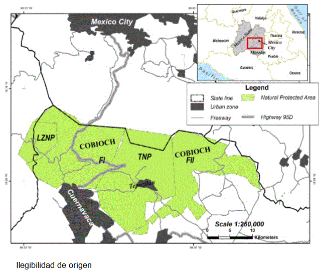
Figure 1 Location of the Corredor Biológico Chichinautzin Protected Area in Mexico. Lagunas de Zempoala National Park (LZNP).;Fraction I (FI) Fraction II (FII); El Tepozteco National Park (TNP).
In this paper we provide evidence of newly occupied areas by R. diazi as well as its annual density within the COBIOCH and its influence area. The outcomes are further discussed in the light of the relevance of this protected area for conservation of the endangered zacatuche rabbit.
Material and Methods
To document the distribution of the zacatuche rabbit, from June to November 2008, and from June to December 2011 we randomly selected 173 points (Appendix 1) from all habitats with bunchgrasses in the COBIOCH. Each point consisted of an area of 50 x 50 m within which exhaustive searches were conducted and latrines counted by at least 4 people. The zacatuche faeces are reliably distinguished from the ones of the other two lagomorphs Sylvilagus floridanus and S. cunicularius due to their size and shape (Hoth et al. 1987). The latrine counting method has been used previously to document the abundance and distribution of the zacatuche rabbit (Fa et al. 1992; Velázquez 1994). In addition, we recorded all zacatuches sighted along the roads and in the grasslands while driving or walking between sampling sites. Each sampling point and rabbit sighting was recorded using the Universal Transverse Mercator (UTM) geographic coordinate system, and was uploaded to a Geographical Positioning System software using a Garmin GPS device (coordinate output to WGS84). With these records, we estimated the area of distribution for the species within the COBIOCH, and we compared it to the distribution area estimated using all of the records reported by Velázquez et al. (1996). In both cases, we first generated a buffer area of 100 m in radius around the location of each record, to determine the area where the species might be located. We then estimated its probable distribution area using the Minimum Convex Polygon method, and the Fixed Kernel Isopleths method, both at a 95 % confidence level (Harris et al. 1990; Worton 1995). The output models for each method were combined spatially (MCP + Kernel model), and were subsequently cut with contours above 2,800 m, the lower elevation limit recorded for the area; finally we intersected it with the polygon of the COBIOCH to measure the area that lies within the protected natural area. The process was performed using the "Animal Movement Analyst" for ArcView 3.2.
The annual density of the zacatuche rabbit was estimated using the line transect method (Buckland et al. 1993). For this, eight reasonably straight, permanent 1000-m-long walking line transects were established, at least 1 km apart, to cover different habitats. Monthly zacatuche rabbit surveys were conducted from March 2010 to February 2011. Two experienced observers conducted the survey, both searching ahead and to each side of the transect while walking at a relatively constant speed of 0.5 km/h. All surveys were conducted between 7:00 and 9:00 h, which is the time of the day when the zacatuche rabbit is most active (Solorio-Damián 2013). The position of rabbits observed on the center line of the transect was recorded as a distance of zero, and for those observed to either side of the transect the distance (m) was recorded perpendicularly from the rabbit to the center line (Buckland et al. 1993) using an electronic distance measuring tool, the Multi Measure Combo Pro (Sonin Inc.). The data were analyzed using the Distance 5.0 program (Thomas et al. 2010) to estimate rabbit density per hectare. To model the detection function of the perpendicular distances, data were pooled across all transects. Three models were considered for the detection function: half-normal, uniform and hazard rate. In each case, the need for cosine adjustment terms was assessed using likelihood ratio tests. In all analyses, 5 % of the longest distances were shortened to avoid bias introduced by outlier distance sightings. The final model was chosen based on a combination of a low value for Akaike's information criterion (AIC) and low variance.
Results
The presence of the zacatuche rabbit was documented at 149 points within the northernmost part of the COBIOCH. It was absent from 24 points with suitable habitat. The records include 48 sightings and 101 pellet counts. The estimated occupied area based on 49 historical records was 56.85 ha. Based on all our field records, the estimated area occupied by this species in the Protected Natural Area and the zone of influence was 166.43 km2 (Table 1). Most of this estimated area (98 ha) is located within the polygon of the COBIOCH. Comparing this area with that estimated based on historical records (Figure 2), this one represents an increase of 109 ha of the occupied area previously known.
Table 1 Estimated area occupied by Romerolagus diazi (km2) based on historical and recent records for the Corredor Biológico Chichinautzin (COBIOCH) Protected Natural Area.
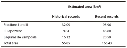

Figure 2 Distribution area of Romerolagus diazi within the Corredor Biológico Chichinautzin based on historical and recent records. LZNP, Lagunas de Zempoala National Park. FI, Fraction I. FII, Fraction II. TNP, El Tepozteco National Park. Estimated areas are provided in Table 1.
During the 12 months of the density survey, a total of 97 zacatuche rabbits were sighted along 96 km of transect. The analysis of this data using the Distance 5.0 software indicates that the half-normal + 1 cosine model provided the best fit to our distance data according to the AIC and variance values (Table 2). This model estimates a density of 4.2 individuals/ha.

Discussion
Our results represent an increase of the knowledge related to the range of the distribution for R. diazi into the COBIOCH and its influence zone. Most of the recent estimated area was not included in the distribution map proposed by Velázquez et al. (1996), which is the basis for the IUCN map (IUCN 2012). Clearly, our findings do not represent an expansion of the zacatuche rabbit in the Sierra de Chihinautzin, but reflects our intensive sampling. Before our field survey, there were only 49 historical records based on collecting data, literature and field surveys conducted in the study area (Appendixes 2 and 3 in Velázquez et al. 1996).
Velázquez et al. (1996) based on those records, together with an analysis of climate, elevation and vegetation maps along the Trans-Mexican Volcanic Belt, recognized six peripheral areas (isolated from each other) for the zacatuche rabbit within the area inside the COBIOCH. Our direct and indirect records point to a different scenario. First, the proximity of all the records indicates that the populations of the zacatuche rabbit might not be isolated from each other and that the rabbits are likely moving between landscapes. The only barrier to dispersal is the highway 95D (Mexico City- Cuernavaca), built in 1952, that crosses the COBIOCH and has barred connectivity between populations on either side of it (Uriostegui-Velarde 2014). Second, Velázquez et al. (1996) recognized as core distribution areas of R. diazi those with suitable habitat where rabbits were sighted and traces (pellets) were found. The results presented here clearly meet these criteria, therefore indicating that the COBIOCH must be also considered a core area of the zacatuche rabbit. Added to that, our result regarding the estimated annual density also provides evidence that the COBIOCH is one of the most important habitats for zacatuche rabbit populations. Density estimated is higher than the only previous report of 1.2 rabbits/ha for the area of the Pelado Volcano using a similar methodology (Velázquez 1994).
These results make an important contribution to our knowledge of the distribution of R. diazi, and the evidence regarding its occurrence and density obtained during this study allow us to suggest that the COBIOCH provides a suitable habitat with conditions that are appropriate for R. diazi to establish and maintain populations with high abundances. It is therefore necessary to implement conservation actions that focus on habitat management and protection in order to avoid the habitat loss and fragmentation that result from grazing, crop cultivation and road construction.