


Serviços Personalizados
Journal
Artigo
 texto em
  Inglês (pdf)
 Artigo em XML
 Referências do artigo
 Enviar este artigo por email
Indicadores
-
 Citado por SciELO
 -
 Acessos
Links relacionados
-
 Similares em
SciELO
Similares em
SciELO
Compartilhar

 Permalink
Intervención (México DF)
versão impressa ISSN 2007-249X
Intervención (Méx. DF) vol.13 no.25 México Jan./Jun. 2022 Epub 13-Fev-2023
https://doi.org/10.30763/intervencion.267.v1n25.46.2022
Academic report
Participatory Risk Mapping for Cultural Heritage. The Case of Tehuantepec, Oaxaca, Mexico

* Coordinación Nacional de Conservación del Patrimonio Cultural (CNCPC), Instituto Nacional de Antropología e Historia (INAH), México, david_torres@inah.gob.mx
** Escuela Nacional de Antropología e Historia (ENAH), Instituto Nacional de Antropología e Historia (INAH), México, paloma.garcia@enah.edu.mx
This academic report verse on the activities carried out in Tehuantepec, Oaxaca, Mexico, as part of a pilot project on risk reduction for local cultural heritage. Its first phase sought to understand, through the identification and analysis of vulnerability factors, the risks faced by this type of heritage located in the first square of the city. To this end, participatory assessment and mapping methods tools were used to generate a risk matrix. Some of the results are the identification of the most culturally relevant sites and the main hazards to them, as well as the design of possible solutions, elaborated on a local level. Finally, some lines of work for subsequent phases are mentioned.
KEYWORDS: risk management; participatory mapping; multi-hazard; cultural heritage; Tehuantepec; disasters
El presente trabajo da cuenta de las actividades realizadas en Tehuantepec, Oaxaca, México, como parte de un proyecto piloto de reducción de riesgos para el patrimonio cultural local. Su primera fase buscó comprender, mediante la identificación y el análisis de factores de vulnerabilidad, los riesgos que enfrenta ese tipo de patrimonio ubicado en el primer cuadro de la ciudad. Para ello se implementaron métodos y herramientas participativas de evaluación y mapeo, con los que se generó una matriz de riesgo. Algunos resultados son la identificación de los sitios de mayor relevancia cultural y de las principales amenazas a éstos así como el diseño de posibles soluciones, elaboradas desde lo local. Finalmente, se mencionan algunas líneas de trabajo para las fases posteriores.
PALABRAS CLAVE: gestión de riesgos; mapeo participativo; multiamenaza; patrimonio cultural; Tehuantepec; desastres
Background
The September earthquakes
In September 2017, one of the most important seismic sequences in the recent history of Mexico occurred. On the 7th, at 23:49 hours (local time), an earthquake with a moment magnitude1 (M) of 8.2 was recorded, with an epicenter at 133 km southwest of Pijijiapan, Chiapas (SSN, 2017a). This was the fourth earthquake recorded with a magnitude greater than M8, which was also associated with a significant number of aftershocks.2 This series of events seriously affected the states of Chiapas, Guerrero and, mainly, Oaxaca, in the area known as the Isthmus of Tehuantepec. The repercussions were particularly acute in the isthmian towns of Juchitan, Santo Domingo Tehuantepec and Ciudad Ixtepec, where, according to the Belisario Domínguez Institute of the Senate of the Republic (2017), a total of 23,304 homes were recorded as affected. Impacts on cultural heritage were also significant, the Instituto Nacional de Antropología e Historia (INAH) reported 587 damaged historic properties in the state, which means that Oaxaca concentrated 25% of the national total (Islas & Sánchez, 2017; Prieto, 2018)3. The Ministry of Culture estimated the national cost of the damage, without specifying the percentage corresponding to cultural heritage, at 1,700,000,000 dollars (Islas & Sánchez, 2017; Torres, 2021).
However, in terms of social impact, the earthquake of September 7th and the sequence of aftershocks that followed surpassed any other seismic event on record in the region (SSN, 2017b). While the magnitude of the phenomenon was remarkable, what was exceptional was the extent of its effects on the condition of the heritage, as there was no equivalent record on previous events of similar behavior. This motivated us to inquire about the additional factors that eventually intervened in the aggravation of the damage, so, as we will see later in this academic report, we decided to adopt a multi-hazard approach that would allow us to extend the analysis of property risk beyond earthquakes.
The institutional response
During the early stages of the emergency of September 7th, 2017, when the need to assess the situation was pressing, the INAH deployed in the affected area a series of multidisciplinary brigades, comprising mainly architects and restorers, and on occasions, archae ologists and anthropologists, whose purpose was to identify and quantify the affected heritage and to record the type and severity of the damage as well as carry out emergency actions of evacuation, protection, rescue and/or immediate safeguarding of the affected property, or at risk of further damage, due to the existing conditions of vulnerability at the time.4
From the experience of the brigades in Tehuantepec, we de tected, primarily through direct observation and first-hand contact with the inhabitants, both the need to deepen the knowledge of the set of risks to which the cultural heritage of the region is exposed and the urgency of developing strategies and coordinated actions between the local population and institutions to prevent or reduce situations that compromise it. In this sense, for example, we observed that in the city of Tehuantepec there is only one specialist in historic buildings; in addition, there is no fire station in the town, nor is there proper equipment for civil protection corps, for an emergency response. The sum of these fundamental deficiencies represents an acute vulnerability factor in terms of both care and prevention. In view of this situation, during the subsequent recovery phase, the INAH, in addition to restoring the historic buildings and the cultural assets contained in them, articulated through its national coordinating brigades a series of research projects, mainly anthropological, which sought to study the different risks that cultural heritage faces.
It is in this context, taking the seismic events as a starting point, but in their articulation with other risk factors derived from the local social context, that the present project arose, which focused on the detection and analysis of the risks to which the heritage of the city of Santo Domingo Tehuantepec is exposed.
Objectives and scope of the project
This paper reports the activities performed in the city of Santo Domingo Tehuantepec, Oaxaca, as part of a pilot project designed by the Coordinación Nacional de Conservación del Patrimonio (CNCPC; National Heritage Conservation Coordination) of the INAH to strengthen the protection of the region’s cultural heritage in the event of calamities.
Its main objective is to generate specific risk reduction strategies in accordance with the local needs of this heritage. To this end, three development phases were proposed: a) risk identification, assessment, and analysis; b) design and implementation of risk reduction strategies; and c) follow-up and monitoring of risk factors and the risk reduction measures implemented. It is important to note that the document presented here is limited to reporting on the work and results of the first of these phases.
Case study: Santo Domingo Tehuantepec
The selection of the case study was based on a series of geo graphic, spatial, and social characteristics of the city, with particular interest both for the relevance of its historical heritage in the regional spectrum and for the conditions that impact its future preservation. In the first place, the city of Tehuantepec has historically occupied a paradigmatic place in the cultural map of the Isthmus region, being a center of commercial confluence of the different ethnic identities and of communication between the populations of the highlands and the coastal plain, as well as an axis of social, political, and administrative reference. It is also a settlement with a long history of disasters caused by environmental phenomena such as earthquakes, tropical storms, and floods. Between 1787 and 1911, more than 100 seismic episodes were recorded with significant effects in the region (García & Suárez, 1996). An example is the earthquake of 1787, which, according to historical sources: “in Tehuantepec, the same tremor ruined the church of St. Sebastian and broke the walls of the temple of St. Dominic” (García & Suárez, 1996, p. 162).5
In this sense, seismic phenomena have had an important impact on the urban configuration and the built space of Tehuantepec. Among other factors, the seismological conditions of the region have influenced the architectural conformation of the traditional house, which comprises thick adobe walls and light wooden roofs and has a single floor in order to endure seismic movements (FAHHO, 2020).
Also, that city is a territory historically hit by multiple hazards besides earthquakes (Torres, 2018), mainly in its historic center. Although the entire region is considered of high seismicity, according to the national zoning of the Centro Nacional de Prevención de Desastres (Cenapred; National Center for Disaster Prevention, 2022), other hazards are also parts of the city’s history, such as floods resulting from the rising of the Tehuantepec River and tropical storms (García, 2018; Reina, 2013; SSN, 2017b). There are records of at least 14 floods or severe storms between 1599 and 1909 (García & Padilla, 2021), for example, the heavy floods of 1599 caused by torrential rains that overflowed the main channel of the river and reached wide extensions of the town, recorded in the sources compiled by García:
the greatest flood that has been seen before or since [...] the floods caused such great havoc that it [sic] knocked down many houses, without sparing doors or roof beams [...] approaching the convent, which is half a league from the river, and on a hill or eminence, about twenty rods high [...] and the water was so strong that it kissed the steps of the churchyard, and the people who escaped by their feet [...] took refuge in the sanctuary of the church and convent; it took four days for the river to go down (Carriedo, 1847, pp. 83-84).
More recently, from 2000 to 2021 alone, 27 emergency declarations for hydrometeorological phenomena were issued in the municipality of Tehuantepec, according to the Sistema Nacional de Información del Agua (Sina; National Water Information System) of the Comisión Nacional del Agua (CNA, 2022 [2000-2021]).6
Equally important are anthropogenic hazards, such as fires, which have become frequent in the surroundings of the urban area due to intensive deforestation and the replacement of lowland rainforest with grazing land. These facts, together with the ac tual and potential occurrence of landslides, intense winds, and prolonged droughts, are high-risk factors,7 with the foreseeable effect of causing tangible and intangible losses in the Tehuano cultural heritage.
On the other hand, Tehuantepec is the city with the highest concentration of sites considered cultural heritage in the Isthmus region, with at least 26 registered religious precincts and more than 200 houses with cultural value, according to the Catálogo nacional de monumentos históricos inmuebles (National Catalog of Immovable Historic Monuments) of the Coordinación Nacional de Monumentos Históricos (CNMH, National Coordination of Historical Monuments, 2022) of the INAH. Coincidentally, that city suffered a great deal of damage to its cultural heritage during the 2017 earthquakes. Speaking only of traditional houses with heritage value, 175 properties were counted with affectations (FAHHO, 2020).
The sum of these geographical, social, and cultural conditions led us to consider Tehuantepec as the starting point of the proposed methodology, particularly in a post-disaster context, which showed an enormous vulnerability in the systems of management and care of cultural heritage. In fact, through the implementation of the first stage of the project, and the analysis of its results, we have sought to initiate a dialogue among diverse actors that will allow us to rethink institutional and citizen strategies for the protection and safeguarding of cultural heritage in the context of disasters, as well as to position the local population as the central element in emergency preparedness.
The pilot project: theoretical-methodological considerations
In Mexico, cultural heritage management and protection systems are often based on institutionalized notions of cultural practices and historic sites. Such practices assimilate the assignment of values (also understood as patrimonialization) as a centralized exercise exclusive to experts, but it leaves aside alternative visions or peripheral expressions of culture (Smith, 2009). However, the value system articulated in the discourse of cultural institutions, coupled with exploitation schemes based on tourism exploitation, has largely undermined broader social participation initiatives that had worked for decades. The loss of the notion of solidarity has produced an alienated version of individualism, without social responsibility, to the detriment not only of the conservation of tangible cultural assets, but also of intangible expressions. For this reason, the pilot project was built from an inclusive conception, starting with the local knowledge of what is considered heritage and the risks it faces.
The first phase of the project focused on strengthening the understanding of the risks to the cultural heritage of the first square of the city, based on Priority 1: Understanding disaster risk, of the Sendai Framework for Disaster Risk Reduction 2015-2030 (2015).8 To this end, participatory assessment and mapping methods and instruments were implemented, complemented by qual itative methodological tools, such as interviews, surveys and field observations, which, as mentioned above, made it possible to work based on local awareness of existing hazards. The tools will be discussed in more detail below.
Through the use of participatory tools such as risk mapping, the identification of sites of cultural relevance and the application of interviews, we sought to generate a change in the institutional discourse and, as a result, in the way in which the conservation of cultural heritage is perceived. Thus, throughout the project, the incorporation of notions such as co-responsibility, inclusion and representativeness related to the different local cultural expressions has been promoted from a horizontal viewpoint, with the aim of boosting a more sustainable practice of cultural heritage protection.
Finally, it should be noted that, although the primary hazard in the region undoubtedly comes from seismic activity,9 a multi-hazard approach was maintained throughout the project. This is based on previous research that has shown that cultural heritage sites often face losses due to unconsidered secondary hazards-for example, fire, landslides or floods-and the concomitance of several of these in compound disasters (Bosher et al., 2019).
In this context, the work developed in 2019 was oriented, mainly through the identification and assessment of vulnerability factors based on community vision, to the analysis of the risks to which the Tehuano heritage is exposed. This sought to establish a solid foundation that would allow informed decision-making on possible solutions for risk reduction.
Methods and tools of the project
To achieve the objectives of the first phase, four complementary qualitative methodological tools were implemented: a) open interviews with key local stakeholders; b) surveys of the general population applied in public spaces in different neighborhoods of the city; c) field observations; and d) a participatory risk identification and mapping workshop.
Open interviews
The ethnographic interview is a formal dialogue guided by the research problem, a characteristic that distinguishes it from spontaneous chats. For the beginning of this project, a series of interviews were conducted with key figures in the Tehuano society, such as the municipal chronicler, the director of Municipal Built Heritage and well-known figures like Xoanas,10 through whom we inquired about their own conception of heritage, that is, about those elements that each one considers fundamental both for the realization of collective activities, identified from the affectations that resulted from the 2017 earthquakes, and for the identity of the community. These interviews allowed us to detect some of the local values, such as collaborative work, celebrations to saints and neighborhood organizations as well as to identify some problematic issues that the population faced during and after the emergency (for example, the damage to religious buildings and their subsequent temporary closure, the deterioration or destruction of some historic buildings, the lack of internal organization to coordinate immediate care actions). They also allowed us to understand that although the ex-convent of Santo Domingo is, due to its regional historical relevance, a heritage reference, the inhabitants do not see it as an isolated work, but as part of a broader complex, which encompasses both the neighborhood chapels and the group of properties that make up the first square of the city.
Survey
A survey was designed with thirteen questions oriented to three main topics: on one hand, the link of the inhabitants with their neighborhood and the degree of participation in the activities that take place there; on the other hand, the place that the ex-convent of Tehuantepec occupies within the patrimonial values of the inhabitants, and finally, the degree of participation that people consider they have when caring for the Dominican building. The purpose of this survey was to identify the role of the neighborhoods in the local identity and internal organization, as well as to corroborate or discard our initial hypothesis that the ex-convent should be the object of analysis for the development of the workshop.
The survey, which was applied randomly during and after the participatory workshop to people belonging to the different neighborhoods of the city, on the one hand, provided very significant information regarding the attachment of the inhabitants-mainly through the chapels and the saints- to their neighborhood of residence, and also on the role played by the territorial sections in the local organization system, and, on the other hand, confirmed the information obtained from the interviews regarding the local appreciation of the Tehuano heritage as a cluster made up of the old convent, the chapels, the municipal market, the government building, the traditional houses and the community activities that take place around each of these sites.
Field observations
The tours-prior and, before and after to the participatory workshop-in the different neighborhoods of the first square of the city provided a first-hand view of the general scenario, that is, of the material conditions of the properties: the distribution of the houses, the layout of the streets and the arrangement of the stores, as well as the daily dynamics of the inhabitants (reasons and places for meetings, work and, commercial dynamics, etc.). The purpose of the previous tours was to familiarize the facilitators with the local dynamics and spatial composition, fundamental for establishing a common basis for dialogue and work through the participatory workshop; in addition, the subsequent tours corroborated the observations and analyses of the workshop participants and, through a map and photographs, the sites they identified as being at greatest risk were graphically documented. The tours were carried out by the authors and the MSc Mitzy Quinto-Cortés, with the support of the architect Luis Mario Díaz.
Participatory workshop
While conservative approaches have maintained a disaster response and recovery-based view of risk management, at an international scale (including the Sendai Framework itself)11, the need to create strategies focused on risk prevention, reduction and mitigation before calamities occur has been raised. Based on this principle, a methodology initially developed by researchers in countries such as Japan, Georgia and Italy (Chmutina et al., 2021; ICCROM, 2020) was implemented and transferred to the Mexican context as part of the Risk Management Subprogram for Cultural Heritage,12 which allows obtaining information on local empirical knowledge about cultural heritage and its risks, as well as responses and forms of adaptation and perception of these and other contextual elements (Bayes et al., 2019; Chambers, 1994; Jigyasu, 2010).
Thus, in July 2019 a workshop based on qualitative methods, consisting of the creation of a series of maps and other graphic resources, was launched in conjunction with key actors and members of the community (Figure 1). The municipal directorates of Built Heritage, Civil Protection and Works, and a representative of the Restoration Workshop of the Fundación Alfredo Harp Helú de Oaxaca (FAHHO), which was involved in the restoration of several damaged sites in the city, participated in the workshop. The workshop was applied by the authors, together with the MSc Mitzy Quinto-Cortés, who was invited to participate in the 2019 season. The main purpose of the workshop was to identify, analyze and discuss the possible vulnerability factors affecting the cultural heritage in the area of study, which was limited to the first square of the city, known as the historic center. The participants worked on the construction of three layers of information, namely:

Layer 1: Identification of exposed systems
The first layer consists of identifying and locating the main cultural sites, assets, spaces and/or practices for the community. The idea is that, with the least possible interference from the facilitators, what is perceived as culturally significant according to the parameters and visions of the participants can be recorded. In this case, for example, the former Dominican convent of the 16th century (currently the house of culture), the neighborhood chapels and the routes of the Holy Week processions were considered as assets of similar relevance. Likewise, “vulnerable” areas with a concentration of people were located in this layer, according to the criteria established by the participants themselves. Thus, the points with the greatest influx of visitors were identified and divided into users (locals) or tourists (nationals or foreigners).
Next, the identified elements were ranked according to their degree of importance for the community. This is achieved by asking the participants to number the sites, objects or practices identified from one to five, where one is the most relevant and five the least.
Layer 2: Identification of hazards
The second layer consists of identifying agents or factors that, in the experience of the participants, represent a danger or hazard to the cultural elements determined in the previous layer. Here again, the hazards are ranked according to their potential consequences on the heritage. Thus, in addition to the risk of earthquakes, areas susceptible to fire or partial collapse and some flood zones were found.
Layer 3: Identification of risk mitigation and reduction strategies
The third layer aim discussing and recording possible solutions to the problems raised. For this purpose, the tools, and resources already available defined, as strengths, that could facilitate the prevention, mitigation, and/or reduction of the foreseen risks. As with the two previous layers, this layer is prioritized according to the experience and sociocultural needs, emphasizing recording the actors that could be directly involved in each activity. Some of the solutions detected were the revision of the public electrical system wiring to ensure it is in good condition and the elimination of areas of waste concentration to avoid fire outbreaks, among other points that will be addressed later.
At the end of each layer, group discussions were held in which participants exchanged ideas and perceptions.
Finally, based on the risks identified in layer 2, a multi-hazard emergency scenario was simulated; in this case, a possible combination of seismic activity, secondary fires and the subsequent occurrence of heavy rains was presented. These circumstances were presented to the participants for analysis, from which it was possible to identify the potential a) damage to buildings and blockage of roads and accesses; b) secondary fires caused by the poor condition of urban electrical wiring, exposure of gas tanks in irreg ular commerce and their direction of propagation; c) areas or spaces of post-earthquake flooding and their impact on damaged cultural heritage; and d) access routes or paths and rescue and evacuation routes for both humanitarian aid teams and cultural heritage protection brigades, including temporary shelter sites for evacuated heritage.
During this last phase, color labels were used to identify challenges and problems (red), strengths (green) and possible solutions (blue). All of them were placed on the map near the reference points to make them easier to read. At the end of the workshop, a series of maps were obtained with information on the risks to which the first square of the city is exposed, which were digitally processed in a later stage of systematization.
Vulnerability matrix
To conclude the workshop, a vulnerability matrix was created jointly by facilitators and participants through tfigurehe analysis and discussion of the information generated in the maps. This activity made it possible to unify criteria, problems, and areas of greatest cultural value, as well as to identify the main risks and red flag areas. As a result, a table (or matrix) was obtained, concentrating the information generated, including the critical risk nodes, the main hazards identified and both the challenges and areas of strength. Based on the knowledge and personal experience of the participants, lines of work, priority areas of attention and possible mitigation measures in the short, medium, and long term were also outlined (Figure 2).
FIGURE 2 Vulnerability matrix created from the collective mapping workshop.
| Studied threat | Description of the threat based on the knowledge of previous events | Identified vulnerability | Proposal for risk reduction/mitigation | Existing strongholds |
|---|---|---|---|---|
| 1. Earthquake (primary hazard) | In 2017 the area was affected for at list two earthquakes of great magnitude, these affected severely a great number of properties in the city. Multiple property considered heritage suffered partial or total collapses. A large number of aftershocks occurred several months latter of the principal earthquakes. The area has continual seismic activity, so the frequency of the telluric events is high. | 1.1 The number of historic buildings still damaged by the 2017 earthquakes, these are in the process of being restored, so the degree of vulnerability of this type of property is even greater than that presented before the earthquakes. Although many of them are shored up, the reinforcements are made of wood and have been exposed to environmental factors for more than two years without receiving protection, so they are already in poor condition. 1.2 A significant number of historic buildings, for residential or religious use, are not yet visibly under restoration projects, so they are highly vulnerable to major damage. 1.3 Ignorance about the internal state of the buildings in poor condition, in an apparent state of abandonment. |
-Carry out the maintenance of buildings that are not damaged, to keep them in the best possible condition. -Restoration of all damaged historic buildings. -Generate a map that allows the location of all historical buildings, whether religious or residential. -Cordoning of areas on the perimeter of damaged buildings that are not receiving attention. -Having a store of special material for evacuation and first aid to cultural heritage. |
A good number of historic buildings are already under restoration. There is a list of historic religious and residential buildings in the city. There is the space of the Bishopric to safeguard objects of patrimonial value, if necessary. |
| 1.4 There is a large number of personnel working inside the affected buildings, so they can be injured by partial collapses, in the event of a new earthquake. | ||||
| 1.5 Areas where it is identified that the present saturation of commercial activity, both pedestrian and vehicular, and this concentration of commercial establishments, represent difficult access for emergency personnel, and in case of partial or total collapse injuries could be caused to the users of the space. | -Relocation of informal/street businesses from the most saturated areas, to reduce vulnerability. -Routes with civil protection in areas of concentration of itinerant and informal businesses. |
There is an administrative body: civil protection, trade, works and health regiduries. Informal commerce relocation project, promoted by the Market Works and Civil Protection Council. |
||
| 1.6 In the event of new collapses, some access routes may be partially or totally obstructed. | -Generate a map with the roads and priority accesses in case of emergency. -Establish priority routes for special use during emergencies. |
They count with a local knowledge of which are the priority roads and the access roads that can be used in an emergency. | ||
| 1.7 Some open spaces identified as safe evacuation zones, or for the triage of people and objects, are likely to be blocked or partially unusable due to landslides. | -Promote the creation of an emergency road cleaning brigade. | There is a civil protection team, together with the manager of bars and canteens, to deal with problems. |
Note: The information in the box is directly related to cultural heritage.
(By: David Torres, Paola García, Mitzy Quinto-Cortés and workshop participants).
Results and discussion
Using the information gathered with these three instruments, the heritage values recognized by the population were identified according to the degree of relevance that they grant to them, as well as the conditions in which they are currently located and the risks to which they would be exposed in the event of a multi-hazard emergency. Subsequently, the project coordinators captured and interpreted the data obtained and the materials created during the workshop, with which a comprehensive analysis of the vulnerability and risk of the heritage located in the first square of the city was carried out. Architect Citlalli Silva scanned the three maps from the participatory workshop to digitize and process the data obtained from them and then design a proposal to interpret them, showing the most information in a single interface (Figure 3).
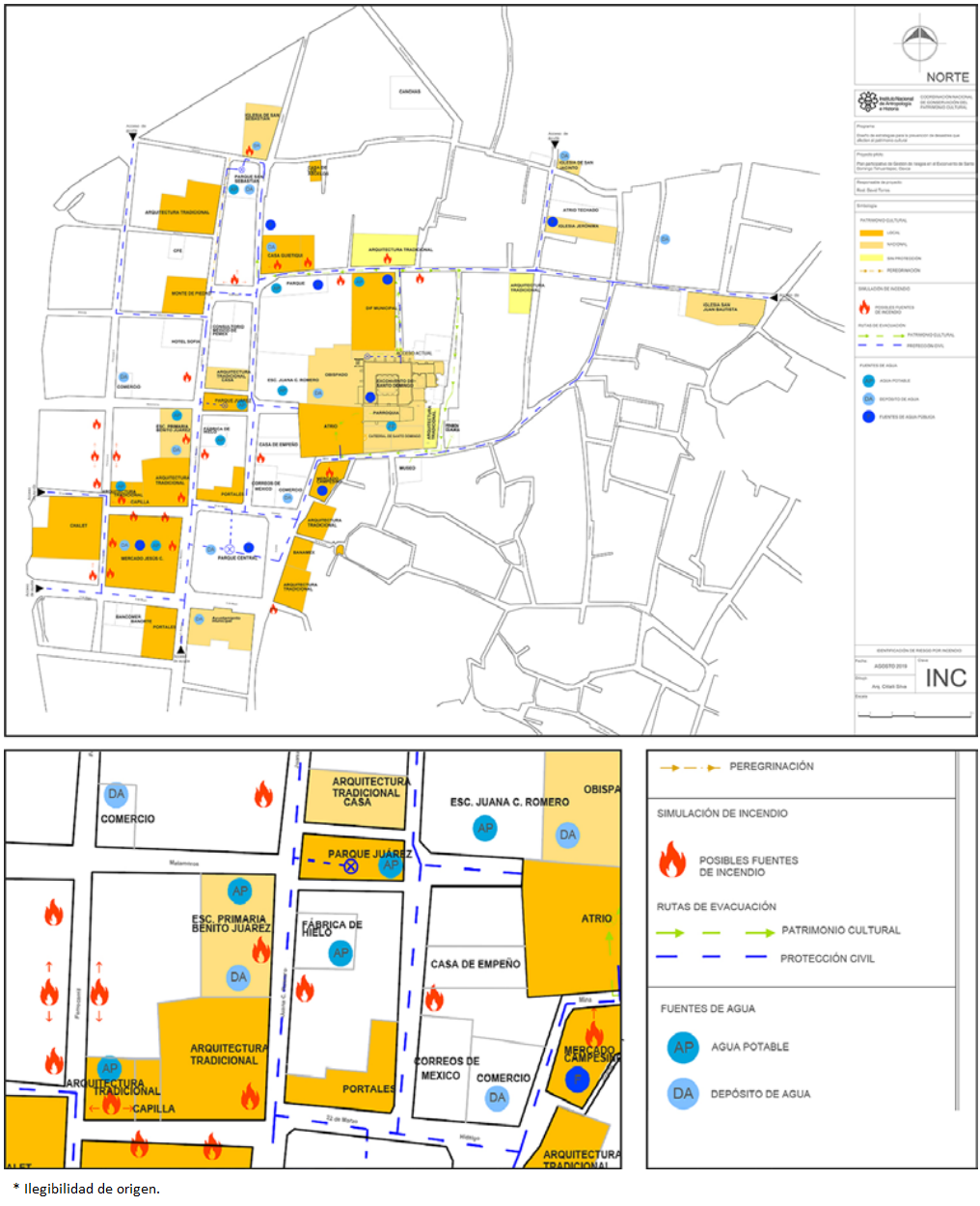
(Creation: Citlalli Silva, 2019).
FIGURE 3 Example of maps created in the participatory workshop once they were digitalized.
The example in Figure 3 shows one of the exit plans, where the points represent a fire hazard, the water sources that could be used to deal with potential fires, and the location of buildings of cultural relevance to the community are observed.
It is worth mentioning that although the project was originally focused on the 16th century Dominican ex-convent, based on the interviews, surveys and the development of the workshop, two premises led to the reformulation and extension of the area of study. Firstly, in the inhabitants’ perception and valuation of the heritage, the former convent is not, as has already been said, an isolated element, but is part of a broader group that integrates, at least, the first square of the city. This area includes, in addition to the old convent, the parish church and the so-called Cathedral, nine of the twenty-two neighborhood chapels13 and the set of images of saints that they protect, spaces that are strategic points of community gathering and celebration. Secondly, the intricate layout of the city’s entire first square as well as the modifications that have been made during the last decades through the construction of new buildings and the expansion of irregular commerce are factors that hindered the intervention to address the damages in the September 2017 earthquake emergency, which can replicate in case of a similar event. As it will be seen below, by expanding the spatial scope of the collaborative mapping it was possible to detect a greater number of risk factors for heritage as well as possible actions to prevent and mitigate them.
Final thoughts
After analyzing the risk maps prepared at the workshop, the participants identified fire and seismic activity as the main hazards to cultural heritage, followed to a lesser extent by flooding. In terms of vulnerability factors, it was detected that the most important for a large part of the historic properties-which at the time of the study were at a very high risk of partial or total collapse-is the lack of maintenance, generally due to the absence of residents or users, or to the damage caused by the 2017 earthquakes. Some sites worth highlighting among the properties identified are the Santo Domingo convent complex, which includes the former 16th century convent and a historic buildings group for religious and residential use that surround it. At the time the workshop was conducted those had not been restored. It is appropriate to carefully analyze the fact that some historic properties that had already been restored at the time of the workshop, particularly residential houses, were also classified by the participants as vulnerable heritage. This is important because it reflects the mistrust that persists regarding traditional construction systems-in this case, adobe, biliguana,14 and tile (cf. Cortés & Cruz, 2014), which are closely related to the perception of risk. It will be necessary to assess this phenomenon in later phases of the project once the restoration buildings are done and reappropriated by the community. During the simulation of an emergency scenario, the participants also recognized the blockage of streets and main avenues caused by the irregular deposit of debris as a relevant risk factor. It was established that, if it is not avoided, it could represent a major cause of vulnerability during the emergency, since it would delay both humanitarian attention and cultural heritage rescue and protection efforts.
On the other hand, the routes of cultural importance that have to do with the course of the processions, the sites of celebration of the neighborhood festivities and the meeting points of the different territorial sections were identified as an essential part of the intangible heritage of the community. For this reason, they were established as a fundamental element, which at all costs would have to avoid being substantially modified or altered-to the extent of losing its symbolic value-by the processes of reconstruction and urban reconfiguration in the post-disaster recovery stage. This fact demonstrates that the tangible elements of Tehuantepec maintain a cultural value for the community due to their associations with immaterial components, but not intrinsically. Overlooking these latter components during the recovery process and throughout the preparation for future emergencies, would represent stripping the heritage of the very essence that makes it a necessary factor for conservation and rescue. As mentioned earlier, in addition to the seismic activity in the region, vulnerability to fires as a result of a lack of urban planning was identified by the participants as a priority. This vulnerability was detected in different points of the first square of the city, including the building that houses the municipal market, a fundamental axis of the daily life of both Tehuantepec and neighboring towns, also identified in the maps as a place of cultural relevance, owing to its relationship with the gastronomic identity of the inhabitants. The area was rated as particularly at risk, as it concentrates a large number of informal businesses that use gas stoves without adequate safety measures-mainly to prevent fires-, increasing the likelihood of an incident. This, together with poor management of waste and residues, accumulated both by the inhabitants and by the poor organization of the local municipality, considerably increases the vulnerability to fires and enlarges the area exposed to this hazard.
The above shows that the municipal market is not only an important element for the life and continuity of activities in the town, but that if it is affected by an incident resulting from a fire, or if it is severely damaged by an earthquake, it could trigger a series of cascading effects, escalating to a situation of greater severity and territorial extension. To this, it must be added that the participants indicated that Santo Domingo Tehuantepec does not have a fire station: emergencies are attended by the station located in the neighboring city of Salina Cruz, at least 30 minutes away, which represents another acute vulnerability factor.
In summary, participants identified the areas of greatest vulnerability to the hazards addressed, where earthquakes and fires are the most important around the convent complex and the municipal market, and although some others of lesser impact were discussed, such as floods, what was proposed to reduce them ended up focusing on reducing vulnerability to earthquakes and fires.
Regarding heritage care specifically, the creation of specialized brigades was proposed, as well as the creation of a warehouse or storage room for materials and for the temporary protection of heritage objects (such as the images of the saints in the neighborhood chapels). In addition, it was proposed to disseminate information among the inhabitants about existing risks and emergency activities on the one hand, and on the other, to create training activities aimed to different strata and sectors of the population, so that they can join the emergency tasks if necessary. Both proposals are strategies to strengthen preparedness.
Similarly, the urgency of addressing the damage caused by the 2017 earthquakes in historic buildings-many of them without a restoration project at that time-was detected in order to avoid greater losses. Of special attention was the recommendation to underpin and recover historic properties that were in apparent abandonment within the first square of the city, as is the case of the building known as the Chalet of Juana C. Romero. This pro posal was based on the recognition of the building’s cultural importance, despite the fact that it is in a state of semi-abandonment.
Another important element observed was the need to take action to improve the public electrical system, which due to its poor condition was identified as one of the main risk factors that may cause a fire and, with it, trigger other cascading effects, which would have the potential to cause even greater destruction. In contrast, the creation of a fire station in the city was not proposed, perhaps because it was perceived it was beyond the reach of the participants.
Conclusions
Through the various activities carried out in the participatory mapping workshop, it was possible to obtain a great deal of information on the potential risks to the cultural heritage of the first square of the city of Tehuantepec, the way in which the inhabitants perceive it and the extent to which they identify with some of the local cultural landmarks.
Two areas were identified as high-risk areas that should be given priority attention: one encompasses the municipal market and the Benito Juárez Elementary School, and the other is the area around the Santo Domingo Cathedral, which includes the so-called Mercado Campesino, classified as a high-risk fire area. Both are sites of great cultural relevance, as deemed by the workshop participants, mainly because of the type of activities carried out there and their relationship with local identity.
It was also possible to observe that the participants perceive the risk of fire as the most likely to occur. This hazard was located in specific areas, where there is a high concentration of informal businesses, debris or garbage. Also, the risk of flooding was regarded as very unlikely to occur, which is why it was considered a lower priority.
The triangulation of information made by the facilitators through field tours and the collection of quantitative information on risks in platforms such as the Atlas Nacional de Riesgos (National Risk Atlas) and the Sistema Nacional de Información del Agua (Na tional Water Information System), allowed confirming that the data mapped during the workshop, based on the knowledge of its participants, coincide with what was identified by the coordinating team. It can then be asserted that the participants have a clear and deep knowledge of the risks that occur in the first square of the city. But, above all, it was observed that the degree of detail of the information they provide is much greater than that provided by institutional information systems. Therefore, the combination of quantitative techniques, such as the risk map generated by Cenapred (2022), with the risk mapping from local knowledge is fundamental to know the panorama of the vulnerability of the city with precision. There is no doubt that the integration of the community from the first phase of the generation of an emergency plan is essential to strengthen the cooperation and co-responsibility of all those involved.
On the other hand, we noted several municipal agencies and the inhabitants themselves are really willing to work to reduce these risks. The dynamics carried out during the workshop succeeded in raising awareness and sparking the interest of the people to take actions and measures in this regard, emphasizing mainly the need to establish an internal organization that assigns roles and res ponsibilities. In this sense, local proposals such as the inspection and maintenance of the entire electrical system of the first square, or the creation of specialized groups for the care of cultural he ritage during emergencies, born from the analysis of the specific needs of the inhabitants, are a solid starting point that could even become the platform for a specialized group in risk management within the town hall of Tehuantepec.
Given the relevance of the results obtained as well as the potential participation that has been shown so far, it is proposed to continue with the development of this project in a second phase, during which we will seek to put into practice the proposals that the first phase delivered. In addition, the results obtained thanks to the systematization of the data will make it possible to give continuity and viability to the joint work for the construction of an emergency plan for the cultural heritage of the first square of the city. It is evident that one of the greatest strengths of this project is the multidisciplinary and participatory work, which has made it possible to build the first collaboration network that will lead to the sustainability of this proposal.
ACKNOWLEDGEMENTS
The authors would especially like to thank architect Luis Mario Díaz Jiménez, Mr. Antonio Díaz and his civil protection team, and Mr. Rómulo Celaya for their invaluable contributions to the project; to the MSc Mitzy Quinto-Cortés for her participation in the 2019 season; to Citlalli Silva for the time invested on the digitalization of the maps; to Casa Guietiqui and the Fundación Alfredo Harp Helú de Oaxaca for the provided support; and the people of Tehuantepec for their concern for the preservation of their cultural heritage.
REFERENCES
Acosta, E. (2007). Zapotecos del Istmo de Tehuantepec. Comisión Nacional para el Desarrollo de los Pueblos Indígenas. https://www.gob.mx/cms/uploads/attachment/file/12599/zapotecos_istmo_tehuantepec.pdf [ Links ]
Bayes, A., Sammonds, P., Sville, N., Le Masson, V., Suri, K., Bhat, G. M., Hakhoo, N., Jolden, T., Hussain, G., Wangmo, K. y Thusu, B. (2019). Indigenous mountain people’s risk perception to environmental hazards in border conflict areas. International Journal of Disaster Risk Reduction, 35, 101063. doi: https://doi.org/10.1016/j.ijdrr.2019.01.002 [ Links ]
Bosher, L., Kim, D., Okubo, T., Chmutina, K. y Jigyasu, R. (2019). Dealing with multiple hazards and threats on cultural heritage sites: An assessment of 80 case studies. Disaster Prevention and Management, 29(1), 109-128. doi: https://doi.org/10.1108/DPM-08-2018-0245 [ Links ]
Carriedo, J. B. (1847). Estudios históricos y estadísticos del departamento de Oaxaca. Imprenta del autor. [ Links ]
Cenapred. (2022). Atlas nacional de riesgos. Centro Nacional de Prevención de Desastres-Gobierno de México. http://www.atlasnacionalderiesgos.gob.mx [ Links ]
Chambers, R. (1994). The origins and practice of participatory rural appraisal. World Development, 22, 953-969. doi: https://doi.org/10.1016/0305-750X(94)90141-4 [ Links ]
Chmutina, K., Tandon, A., Kalkhitashvili, M., Tevzadze, M. y Kobulia, I. (2021). Connecting heritage, vulnerabilities and capacities through a participatory game. International Journal of Disaster Risk Reduction, 53, 102005. doi: https://doi.org/10.1016/j.ijdrr.2020.102005 [ Links ]
CNA. (2022 [2000-2021]). Declaratorias por fenómenos hidrometeorológicos por municipio. Sistema Nacional de Información del Agua-Comisión Nacional del Agua. http://sina.conagua.gob.mx/sina/tema.php?tema=declaratoriasFenomenos&ver=mapa&o=0&n=nacional [ Links ]
CNMH. (2022). Catálogo nacional de monumentos históricos. Coordinación Nacional de Monumentos Históricos-Instituto Nacional de Antropología e Historia. https://catalogonacionalmhi.inah.gob.mx/consultaPublica [ Links ]
Cortés, B. y Cruz, F. (2014). El chalet de Juana “Cata” Romero. Un monumento artístico reminiscente en el Istmo de Tehuantepec, Oaxaca. La Gaceta del Instituto del Patrimonio Cultural del Estado de Oaxaca, 27, 14-25. http://todopatrimonio.com/pdf/GacetaINPAC/Gaceta27.pdf [ Links ]
FAHHO. (2020, enero-junio). Rescate de las casas tradicionales de Santo Domingo Tehuantepec, Oaxaca. Patrimonio devastado por los sismos de septiembre de 2017. Memorias de Restauración. Taller de Restauración FAHHO, 12. Taller de Restauración de la Fundación Alfredo Harp Helú de Oaxaca. https://tallerderestauracionfahho.org/wp-content/uploads/2020/01/Casas-Tradicionales.-WEB-2019.pdf [ Links ]
García, V. y Suárez, G. (1996). Los sismos en la historia de México (Vol. 1). Universidad Nacional Autónoma de México/Centro de Investigaciones y Estudios Superiores en Antropología Social/Fondo de Cultura Económica. [ Links ]
García, P. (2018). Los efectos de los terremotos y las inundaciones de septiembre de 2017 en San Mateo del Mar. Rutas de Campo (3), 52-68. https://revistas.inah.gob.mx/index.php/rutasdecampo/article/view/14647 [ Links ]
García, V. y Padilla, R. (2021). Catálogo de huracanes y otros episodios hidrometeorológicos en la historia de México. En V. García y R. Padilla (Coords.). Historia y memoria de los huracanes y otros episodios hidrometeorológicos extremos en México. Cinco siglos: del año 5 pedernal a Janet (pp. 371-410). Centro de Investigaciones y Estudios Superiores en Antropología Social/Universidad de Colima/Universidad Veracruzana. https://libros.uv.mx/index.php/UV/catalog/view/FC304/1607/2033-1 [ Links ]
Gobierno de Oaxaca. (2017). Diagnóstico Regional Istmo. 11. https://www.oaxaca.gob.mx/coplade/wp-content/uploads/sites/29/2021/04/DR-Istmo.pdf [ Links ]
ICCROM. (2020). InSight. A Participatory Game. International Centre for the Study of the Preservation and Restoration of Cultural Property. https://www.iccrom.org/sites/default/files/Insights_FINAL-LAYOUT_131020.pdf [ Links ]
Islas, I. y Sánchez, M. (2017). Recuento de los daños 7S y 19S: a un mes de la tragedia. Notas Estratégicas 17, 1-8. http://bibliodigitalibd.senado.gob.mx/bitstream/handle/123456789/3721/2017_16_NE_Recuento%20de%20da%C3%B1os_231017.pdf?sequence=1&isAllowed=y [ Links ]
Jigyasu, R. (2010). Rediscovering traditional knowledge for post-disaster reconstruction through “participatory” research methods in India and Nepal (pp. 99-112). Participatory Research Methodologies: Development and Post-Disaster/Conflict Reconstruction. [ Links ]
ONU. (2015). Marco de Sendai para la Reducción del Riesgo de Desastres 2015-2030. Organización de las Naciones Unidas. https://www.unisdr.org/files/43291_spanishsendaiframeworkfordisasterri.pdf [ Links ]
Pérez-Campos, X. y Espíndola, V. H. (2018). La realidad geológica, una amenaza al patrimonio cultural de México (los sismos de 2017). En B. Cottom (Ed.), Sismos y patrimonio cultural. Testimonios, enseñanzas y desafíos, 2017 y 2018 (pp. 49-61). Secretaría de Cultura. https://www.mediateca.inah.gob.mx/islandora_74/islandora/object/libro:738 [ Links ]
Prieto, D. (2018). Sismos y patrimonio cultural. Destrucción y restauración. En B. Cottom (Ed.), Sismos y patrimonio cultural. Testimonios, enseñanzas y desafíos, 2017 y 2018 (pp. 109-123). Secretaría de Cultura. https://www.mediateca.inah.gob.mx/islandora_74/islandora/object/libro:738 [ Links ]
Reina, L. (2013). Historia del Istmo de Tehuantepec: dinámica del cambio sociocultural, siglo XIX. Consejo Nacional para la Cultura y las Artes/Instituto Nacional de Antropología e Historia. [ Links ]
Smith, L. (2006). Uses of Heritage. Routledge. [ Links ]
SSN. (2017a). Sismo de Tehuantepec (2017-09-07 23:49 Mw 8.2). Reporte especial. Grupo de Trabajo del Servicio Sismológico Nacional. Universidad Nacional Autónoma de México/Geofísica UNAM/Servicio Sismológico Nacional. http://www.ssn.unam.mx/sismicidad/reportes-especiales/2017/ssnmx_rep_esp_20170907_Tehuantepec_M82.pdf [ Links ]
SSN. (2017b). Sismo del día 19 de Septiembre de 2017, Puebla-Morelos (M 7.1). Reporte especial. Grupo de Trabajo del Servicio Sismológico Nacional. Universidad Nacional Autónoma de México/Geofísica UNAM/Servicio Sismológico Nacional. http://www.ssn.unam.mx/sismicidad/reportes-especiales/2017/SSNMX_rep_esp_20170919_Puebla-Morelos_M71.pdf [ Links ]
Torres, D. A. (2018). The Dominican Convent of Tehuantepec, Mexico. A Disaster Risk Management draft plan. En R. Jigyasu y D. Kim (Eds.), Proceedings of unesco Chair Programme on Cultural Heritage and Risk Management, International Training Course (ITC) on Disaster Risk Man agement of Cultural Heritage (pp. 54-61). Institute of Disaster Mitigation for Urban Cultural Heritage, Ritsumeikan University/United Nations Educational, Scientific and Cultural Organization/International Centre for the Study of the Preservation and Restoration of Cultural Property/International Council on Monuments and Sites-International Committee on Risk Preparedness. https://rdmuch-itc.com/wp-content/uploads/Proceedings_of_ITC_2018.pdf [ Links ]
Torres, D. A. (2021). Community organization for the protection of cultural heritage in the aftermath of disasters. International Journal of Disaster Risk Reduction, 60, 102321. doi: https://doi.org/10.1016/j.ijdrr.2021.102321 [ Links ]
Trejo, L., Oseguera, A., Hope, M. y Acosta, T. (investigadores), Millán, S. (Coord.). (2008). Oaxaca. Condiciones socioeconómicas y demográficas de la población indígena. Región Sur (Tomo 1). Comisión Nacional para el Desarrollo de los Pueblos Indígenas/Programa de las Naciones Unidas para el Desarrollo. https://www.inpi.gob.mx/2021/dmdocuments/region_sur_tomo_1_oaxaca.pdf [ Links ]
1Moment magnitude is a logarithmic scale based on measuring the total energy being released during an earthquake (Pérez-Campos and Espíndola, 2018).
2The Servicio Sismológico Nacional (SSN, National Seismological Service, in Eng lish) recorded over 23,000 aftershocks: 482 in the Gulf of Tehuantepec only in the first two days of November, with more than 40 events of a magnitude higher than 5, being the highest of 5.8. (SSN, 2017a, 2017b).
4For example, historic buildings with important water filtrations caused by the rain, new collapses of architectonic elements over movable assets due to the aftershocks or theft of sacred art, being exposed in buildings with partial collapses.
5Editorial translation. All quotes where the original text is in Spanish are also editorial translations.
6The Sina, of the CNA, can be consulted at http://sina.conagua.gob.mx/sina/tema.php?tema=declaratoriasFenomenos&ver=mapa&o=0&n=nacional.
7These risks were even reported in 2014 as of priority attention by the Centro Mario Molina in its Territorial and Sectoral Strategic Information for the Adaptation to Climate Change.
8Priority 1 of the Sendai Framework states that “Policies and practices for disaster risk management should be based on an understanding of disaster risk in all its dimensions of vulnerability, capacity, exposure of persons and assets, hazard characteristics and the environment” (UN, 2015, p. 14).
9According to the Atlas nacional de riesgos (National risks Altas), the region of the Isthmus of Tehuantepec is located in the area ranked with the highest seismic risk.
10Xoana, from Zapotec xhuaana that means ‘main’ o ‘steward’; is the person responsible for giving continuity to traditions. They act as the moral authority of a neighborhood.
11Priority 3 states that “investing in disaster risk reduction for resilience” is necessary, while Priority 4 asserts the need “to further strengthen disaster preparedness for response, take action in anticipation of events [and] integrate disaster risk reduction in response preparedness” (UN, 2015, p. 14).
13Although the neighborhoods have varied historically, there are currently thirteen: La Soledad, Santa Cruz, Santa Maria, San Juanico, Lieza, Jalisco, Laborio, San Sebastian, San Antonio, Guichivere, San Francisco, Vixhana and San Jeronimo.
14Biliguana is a wooden element that is part of a constructive system of traditional houses in the region of the Isthmus (FAHHO Restoration Workshop, 2020, p. 39).
Received: July 26, 2021; Accepted: August 31, 2022; Published: December 28, 2022
 Este es un artículo publicado en acceso abierto bajo una licencia Creative Commons
