


Services on Demand
Journal
Article
 text in
  English (pdf)
 Article in xml format
 Article references
 Send this article by e-mail
Indicators
-
 Cited by SciELO
 -
 Access statistics
Related links
-
 Similars in
SciELO
Similars in
SciELO
Share

 Permalink
Tecnología y ciencias del agua
On-line version ISSN 2007-2422
Tecnol. cienc. agua vol.11 n.1 Jiutepec Jan./Feb. 2020 Epub May 30, 2020
https://doi.org/10.24850/j-tyca-2020-01-02
Articles
Keys to improve IWLRM: Three laboratories in Andalusia, Spain

1Departamento de Urbanística y Ordenación del Territorio, Universidad de Granada, España, merespavil@ugr.es, merespavil@hotmail.com
2Research Cluster on Territorial Synergies (CLUSTER), Departamento de Urbanística y Ordenación del Territorio, Universidad de Granada, España, lvmontes@ugr.es
1ETS Ingeniería de Caminos, Canales y Puertos, Campus de Fuentenueva s/n, 18071, Granada, España
Achieving more sustainable water resource management undoubtedly requires integrated management together with land resources, as has been affirmed in scientific and technical forums around the world for various decades. However, this general consensus has not been transformed into effective results due to the existence of a range of obstacles (administrative, conceptual and temporal). This article suggests means of improving the drafting of spatial and river basin management planning instruments to achieve more integrated management during the application phase in their respective areas of influence. Modifications to the content of these plans are proposed in accordance with a reference framework that addresses relevant aspects of IWLRM based on three different dimensions (presence, effectiveness and coherence), allowing definition of ‘model plans for IWLRM’ in specific spatial areas. Based on this approach, a methodology has been developed that compares the model plans with the existing plans in order to assess the aptitude (high, medium, low) of these instruments to achieve IWLRM and also to facilitate identification of the keys to achieve improvements in terms of IWLRM. Three zones of Andalusia (Spain) have been used as territorial laboratories. Following an evaluation of their main planning instruments from the perspective of IWLRM, the keys to their improvement in order to achieve more integrated management in these zones have been identified.
Keywords Water and land resources; integrated management; planning instruments; information framework; key improvements
El logro de una gestión más sostenible de los recursos hídricos requiere sin duda una gestión integrada junto con los recursos territoriales, y así se viene afirmando en los foros científicos y técnicos de todo el mundo desde hace varias décadas. Este consenso generalizado no se ha traducido, sin embargo, en resultados efectivos debido a la existencia de impedimentos de diversa índole (administrativos, conceptuales, temporales…). El presente artículo plantea mejorar la redacción de los instrumentos de planificación (de naturaleza territorial e hidrológica) para que durante sus fases de vigencia se alcance en sus ámbitos de aplicación una gestión más integrada. Se sugieren cambios en cuanto al contenido de los planes según un marco de referencia que incluye el tratamiento de cuestiones relevantes para la gestión integrada de recursos hídricos y territoriales (GIRHT) desde tres dimensiones distintas: presencia, efectividad, coherencia, lo que permitirá definir “planes modelos para la GIRHT” en ámbitos espaciales concretos. A partir de esta propuesta se desarrolla una metodología que compara los “planes modelo” y los planes existentes, con el fin de evaluar la aptitud (alta, media, baja) de tales instrumentos para lograr la GIRHT, y además facilita la identificación de claves para alcanzar mejoras. Se han empleado como laboratorios territoriales tres ámbitos de Andalucía, España, en los que, tras evaluar sus principales instrumentos de planificación desde la perspectiva de la GIRHT, se han identificado las claves para mejorarlos y alcanzar así una gestión más integrada en dichas zonas.
Palabras clave recursos hídricos y territoriales; gestión integrada; instrumentos de planificación; marco de referencia de contenidos; claves de mejora
Introduction
Integrated Water and Land Resources Management (hereinafter ‘IWLRM’) has been widely accepted (Falkenmark & Rockström, 2004; Calder, 2005; UNU-IHDP, 2014) as an effective means of achieving more appropriate management of these two types of resources after nearly three decades of intense debate (Mitchell, 1990; Calder, 1998; Carter, Kreutzwiser, & DeLoë, 2005; Del Moral, 2006; Woltjer & Al, 2007; Ingram, 2008; Carmon & Shamir, 2010; Smith, Blackstock, Wall, & Jeffrey, 2014; Borchardt, Bogardi, & Ibisch, 2016), as it minimises both currently existing environmental and socio-economic problems (GWP, 2000; Jonch-Clausen & Fugl, 2001; Calder, 2005; GWP, 2008) and also potential future problems which cannot be addressed from a sectorial perspective (Moss, 2004; Mukhtarov & Gerlak, 2014).
The different options proposed to achieve more integrated management include coordination of the content of spatial and river basin management planning instruments (Carter, 2007; Del Moral, 2009). But in order for modifications to the content of these instruments to be realistic and truly allow advances to be made, they must be conceived from the perspective of integration proposed by Mitchell (1987, 2005, 2008, 2015), which focuses on the main water-land variables existing in the area of application and their essential interrelationships.
Adopting this approach, this article identifies some of the keys to carry out modification of the content of spatial and river basin management planning instruments in Andalusia (Spain) so that during their term of application advances can be made in the field of IWLRM.
In order to identify these keys, the article begins by asking what these plans should be like from the perspective of IWLRM, with an attempt being made to define a ‘model plan’ for this purpose. This requires us to address the following issue: how can we evaluate the aptitude of the planning instruments currently being applied? We have developed our own working methodology to compare the plan evaluated with the model plan previously defined (for the specific study zone) in order to determine whether the aptitude for IWLRM is high, medium or low.
Three Andalusian territorial laboratories: characterisation with an integrated focus
The proposals included in this article to improve IWLRM are based on the reality of the Andalusian region and have been defined for this specific context. In order to test the methodology, three territorial laboratories have been selected in Andalusia at a subregional scale: the Eastern zone of Almería, the Northwest Coast of Cádiz and the Western Coast of Huelva.
Regulatory-administrative framework
In Spain, the Autonomous Administrations have exclusive competence in the area of spatial planning (Feria, Rubio, & Santiago, 2005). More specifically, in Andalusia these matters are governed by Ley 1/1994 de Ordenación del Territorio (Ley 1/1994, 1994, on Spatial Planning). This Law establishes two instruments for spatial planning of the entire territory: the Andalusian Land Use Plan and the Subregional spatial plans. The territorial laboratories selected all have spatial plan approved, the names of which have been used to identify them: Spatial plan of Western Coast of Huelva (approved in 2006); spatial plan of Eastern zone of Almería (2009); spatial plan of Northwest coast of Cádiz (2011).
It is also necessary to consider urban planning instruments, with the most relevant of these in Andalusia being the Municipal Land Use Plans (Law 7/2002). Within each of the territorial laboratories, two municipalities have been selected, for which the municipal land use plans were analysed: Antas (2009) and Vera (2009) in the Eastern zone of Almería; Chipiona (2005) and Rota (2008) on the Northwest Coast of Cádiz; and Lepe (2015) and Cartaya (2015) on the Western Coast of Huelva.
In terms of water management, there have been two major legislative developments in Andalusia during this century:
The entry into force of the EU Water Framework Directive 2000/60/EC (hereinafter ‘WFD’), which introduced the concept of river basin districts and dispensed with the approach based on river basins. This required a reorganisation of the sectorial administration. While until that time Andalusia had been subject to four river basin management plans, it then became subject to six.
The transfer to the autonomous administration of the powers relating to intra-regional river basin districts (Andalusian Mediterranean Basin District; Guadalete-Barbate River Basin District; Tinto-Odiel-Piedras River Basin District) in 2005 and 2006.
A large part of the surface area of the three laboratories selected is affected by river basin plans supervised by the Andalusian Autonomous Government, consisting of river basin management planning instruments that will be evaluated to determine their aptitude for IWLRM, all of which were approved in 2016: Tinto-Odiel-Piedras River Basin plan; Andalusian Mediterranean river basin plan; Guadalete-Barbate river basin plan.
Figure 1 shows the location of the laboratories selected and the zones of the main planning instruments affecting their spatial and river basin management which will be analysed in this article.

Natural and socio-economic features
The natural and socio-economic characteristics of the three study laboratories are summarised in Figure 2.
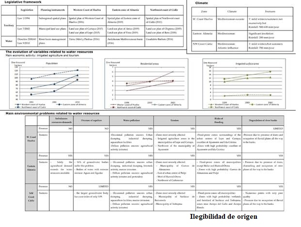
As can be seen in the above figure, the conditions of the three laboratories are very similar:
They are coastal zones with predominance of a Mediterranean climate;
The main economic activities are related to irrigated agriculture and tourism (both activities with high water demands);
Over the last 15 years they have undergone an important evolution in terms of built surface area;
They face important environmental problems linked to water and spatial planning, while at the same time being zones of major environmental interest.
Materials and methods
Modification of the content of the plans to promote IWLRM
Starting from the basis that common treatment of water and land variables and the main interrelationships between them can favour more integrated management during the term of application of plans (España-Villanueva & Valenzuela-Montes, 2016), firstly we will define the information framework which planning instruments must comply with in order to make advances in terms of IWLRM and which will form the basis of the model plan required to achieve the objective defined.
Definition of the information framework to be applied to the plans to promote IWLRM
When considering water and land resources from the perspective of integration, it is essential to take into account the characteristics of the intervention zone to ensure the actions taken are successful. Before determining which are the most significant resources linked to these variables (GWP-INBO, 2009) in the Andalusian laboratories chosen, which we have called ‘water-land integration items’, the generic structure of the information framework is presented in Figure 3, consisting of:
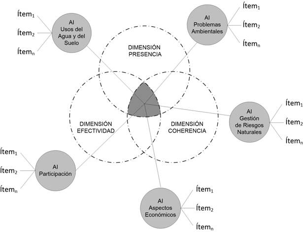
Integration Areas (hereinafter ‘IA’): these are the main aspects to be addressed by any spatial or river basin management plan from an integrated perspective.
Based on a review of previous studies (Jonch-Clausen & Fugl, 2001; Kidd & Shaw, 2007; GWP-INBO, 2009; Del Moral, 2009; Plummer, Grosbois, Loë, & Velaniskis, 2011; Mitchell, 2015) and an analysis of European water management regulations (particularly the WFD and part of the implementing legislation, such as Spanish Royal Decree 907/2007); five IA have been recognised: water and land uses; environmental problems; management of water-related natural risks; economic aspects; participation
Information dimensions: this refers to three requirements to be met by the information included in plans relating to IA:
Presence Dimension (hereinafter ‘PD’). This refers to the need for incorporation of information to improve integration through intervention at planning level (Molle, 2008).
Effectiveness Dimension (hereinafter ‘ED’). This refers to the requirement that plans must incorporate measures and proposals which when developed during the management phase contribute towards advances in terms of IWLRM. These must accordingly be operative proposals.
Coherence Dimension (hereinafter ‘CD’). This highlights the undisputed consistency that must exist between spatial and river basin management plans applicable in the same zone to allow advances to be made in the field of IWLRM.
Based on the characterisation of the three Andalusian territorial laboratories selected (Figure 2), the water-land integration items would be those specified in Table 1 (identical for the three zones given that they have similar natural and socio-economic features and the same regulatory framework). The items for which the CD will be taken into consideration have been highlighted in bold.
Table 1 Specific water-land integration items for the Andalusian laboratories selected.
| Integration Areas | Items |
| Water and land uses | Management units defined with spatial and hydrological criteria Recent information on the water resources available in each management unit Recent, specialised information on water and land uses Possible scenarios (medium-term) of water and land uses Location of main bodies of water Measurements and parameters for protection of bodies of water Limits on the demands for water resources Measures to maintain or restore balance between resources and consumption |
| Environmental Problems | Identification of bodies of water with pollution or at risk Recent information on pollution sources Measures to prevent or eliminate pollution of bodies of water Identification of aquifers that are overused or at risk Measures to prevent or alleviate overuse Identification of zones with water erosion or at risk Restriction on certain uses and activities in zones with risk of water erosion Prevention or improvement measures in zones with erosion |
| Management of water-related natural risks | Location of flood-prone zones Restriction on certain uses and activities in flood-prone zones Preventive or action measures for flash floods Extraordinary measures in the event of drought |
| Economic aspects | Budget allocation of the measures proposed for other essential aspects Recovery of the cost of water services and capital, environmental and resource costs |
| Participation | Procedures for cooperation with other administrations of differing nature and/or scale Formula to initiate participatory processes in the different phases for drafting of plans. Incorporation of certain contributions made in the participatory process in the final version of the plans Mechanism for feedback in the management phase |
Evaluation of the aptitude of current plans to promote IWLRM
Essentially, the methodology designed aims to determine the divergence between the plan evaluated and what is considered to be the model plan (which is in accordance with the information framework). Three partial results will be obtained, one for each Information Dimension, which will determine whether the plan evaluated has high, medium or low aptitude in terms of IWLRM.
The methodology is structured in various phases (Figure 4), with two ways to proceed in the third phase: one is to apply the Presence and Effectiveness dimensions and the other is for the Coherence dimension (this dimension requires a comparison between the plan evaluated and other plans currently applicable in the same zone).
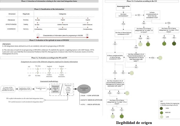
As can be seen in Figure 4, following the extraction of information relating to the water-land integration items contained in the plan analysed (Phase 1) and their classification (Phase 2), the evaluation according to the PD and the ED (Phase 3.a) requires allocation of values (0, 1 or 2) to the information according to its previous categorisation, totalling of the values by Information Areas and application of weighting factors for each IA (applying a Hierarchical Analysis tool; Saaty 1977). Subsequently, and following the previous calculation of the maximum possible value for the aptitude (the value of the model plan, which would have detailed information on all the respective items and useful proposals), the values are then standardised, dividing the value of the plan evaluated by the maximum possible value. The final result of the aptitude would be:
Standardised value of aptitude (for PD and ED) between 0-0.25( low aptitude for IWLRM.
Standardised value of aptitude (for PD and ED) between 0.25-0.75( medium aptitude for IWLRM.
Standardised value of aptitude (for PD and ED) between 0.75-1( high aptitude for IWLRM.
The evaluation of the aptitude of the plans according to the Coherence Dimension (Phase 3.b) following classification of the information extracted from the plan (Phase 2) requires application of the flow diagram designed, which takes into account the two premises recognised in the methodology (highlighting the inconsistencies in those IA with the highest weighting factors).
Results
Aptitude for IWLRM of current planning instruments in the territorial laboratories
Applying the methodology described to the 12 planning instruments selected (with application in the three Andalusian laboratories) the aptitude for IWLRM during the term of application of the instruments has been obtained.
In order to facilitate an understanding of the results, for each plan three partial results (one for each Information Dimension) have been represented in a graph with three axes and they have then been joined together to make a triangle, the area of which may be interpreted as the global aptitude of the plan evaluated in terms of IWLRM.
The results are set out in Figure 5. Subsequently, the most significant findings during the evaluation process of the plans in each of the territorial laboratories have been outlined.

Figure 5 Graphical representation of the results obtained in the plans of three Andalusian laboratories.
Western Coast of Huelva
An analysis of the results in Figure 5 corresponding to the plans for this laboratory show that the larger scale instruments are better suited to contribute to IWLRM, with the spatial plan and river basin management plan having larger graphical areas than the municipal land use plans evaluated (Cartaya and Lepe).
Following an analysis of the content of the four plans, the following aspects by Integration Area should be highlighted due to their significance in terms of IWLRM:
IA ‘Water and land uses’: the incoherence detected between the graphical documentation of the spatial plan and the municipal land use plans of Cartaya and Lepe referring to land classification is particularly striking. Various zones with a total surface area of around 1,000 ha are considered to be non-development land in the spatial plan yet they are considered to be development land in the municipal plans. This contradiction in itself constitutes a barrier for IWLRM in the zone, as it affects not only the land use but also the demand for water resources and management of the associated risks and problems.
IA ‘Environmental problems’: this is one of the most important integration areas to promote IWLRM, as is evident from the weighting factor assigned in the methodology. However, there is plenty of scope for improvement in the results of the four plans evaluated, given that in relation to the Presence Dimension this IA obtained (standardised values): 0.75 in the spatial plan; 0.62 in the river basin plan; 0.44 in Lepe municipal land use plan; and 0.12 in Cartaya municipal land use plan.
IA ‘Management of water-related natural risks’: The approach taken by the plans of this territorial laboratory regarding these risks is positive, including information and operative measures to reduce their effect. Nonetheless, some findings were surprising, such as the absence of delimitation of the flood-prone zones in the Tinto, Odiel and Piedras river basin management plan.
IA ‘Economic Aspects’: the results for this IA were very inconsistent. They were positive for the river basin management plan and the spatial plan as they included budget references for the majority of the measures proposed and referred to different mechanisms for recovery of the costs of water services. In the case of the municipal land use plans, no reference is made to any of the items included in this IA.
IA ‘Participation’: generally speaking, the results were negative. While at least in theory the river basin management plan has mechanisms for active participation during the drafting phase, the spatial plan and the municipal land use plan do not even mention any, relegating participation to a period of public viewing of the document once it has been drafted.
Eastern zone of Almería
Reaffirming the results obtained in the first laboratory, the larger scale plans of the Eastern zone in Almería were best suited to promote IWLRM according to the methodology employed (Andalusian Mediterranean Basin Management Plan). Upon detailed analysis of the information extracted from the plans for each IA, certain issues of major importance for IWLRM were detected.
IA ‘Water and land uses’: in a zone where problems relating to imbalances between resources and demand are of major importance (see Figure 2), it is noteworthy that the spatial plans (both the spatial plan and the municipal land use plans) do not recognise any limits on water demands for any activity.
In this IA, various inconsistencies have been detected between the land classification of the spatial plan and the two municipal plans. Above all, because the surface areas classified as development land by the spatial plan (approved in 2009) are very significant, although in reality they are actually already developed, as is reflected in the planning maps of the municipal land use plans (approved that same year). This represents a setback for IWLRM, given that as they are not considered as urban zones in the spatial plan, it is not in accordance with reality and does not contemplate the demand for water resources of these plots, their water treatment needs, the potential environmental problems that could be derived from these urban developments and the infrastructure necessary to minimise the risk of flash floods.
IA ‘Environmental problems’: it is noteworthy that there is an absence of explicit measures in both the spatial plan and the river basin plan to counter the effects of water erosion, even though this is a very relevant problem in the zone. Also significant is the absence of measures in the spatial plan to prevent or alleviate the overuse of aquifers (which affects more than 80% of bodies of groundwater). In the municipal land use plans, for the items included in this IA only two references were found to the item regarding measures to prevent water pollution in the Antas municipal land use plan(in the Vera municipal land use plan there is no information for any of the eight items).
IA ‘Management of water-related natural risks’: the spatial plan of this territory delimits flood-prone zones and in section 74 establishes that zones not developed prior to approval of the plan will be considered as non-development land. However, upon comparing this delimitation with the land classification of the Vera municipal land use plan (approved that same year) more than 100 ha of development land was detected, located in flood-prone zones (T=500 years) along the coastline.
IA ‘Economic aspects’ and IA ‘Participation’: the results obtained for these Integration Areas are similar to those obtained in the previous laboratory, with budget references in the larger scale plans for nearly all the measures listed and absence of information in this regard in the municipal land use plans. For participation, the river basin plan once again has better results as it includes information regarding the four integration items contemplated. The spatial plan contemplates public viewing of the document, although it does not have any active participation mechanisms.
Northwest Coast of Cádiz
The aptitude for IWLRM of the plans relating to this laboratory is similar to that obtained following application of the methodology to the planning instruments of the other laboratories previously commented. The only noteworthy feature is the smaller area of the graph of results for the Northwest Coast of Cádiz spatial plan compared to the other two subregional plans evaluated.
By Integration Area, the following aspects may be highlighted:
IA ‘Water and land uses’: as opposed to the observations in the case of the other municipal land use plans evaluated, the Chipiona municipal land use plan has a more restrictive land classification than the spatial plan, with the spatial plan identifying certain plots as development land when they are not considered as development land in the municipal plan.
The Rota municipal land use plan was found to have certain differences upon comparing the land classification with that of the spatial plan, given that some plots were classified as urban in the municipal land use plan (approved in 2009) and as development land in the spatial plan (approved in 2011), which has negative implications for IWLRM.
IA ‘Environmental problems’: one positive aspect to highlight is the large amount of information found in the plans evaluated regarding water pollution, which is one of the environmental problems existing in the zone (Figure 2) and which according to the River Basin Management Plan in force is likely to persist in the medium term. Another positive aspect regarding the information linked with this IA is the incorporation of “measures to prevent or alleviate overuse”.
IA ‘Management of water-related risks’: The results in this area are not as positive. The spatial plan has a delimitation of flood-prone zones, even highlighting the urban land located in these zones. The river basin plan, as in the case of the laboratory in Huelva, does not include this information. In relation to risk of drought, the spatial plans (spatial plan and municipal land use plan) do not even mention this issue in the documents.
IA ‘Economic aspects’ and ‘Participation’: the results for these two areas are similar to those described in the previous laboratories, namely, budget allocation for the measures outlined in the spatial plan, but above all in the river basin plan, and non-existent in the municipal land use plans. In addition, there is information for all the items of the participation area in the river basin plan, with the spatial plan solely contemplating public viewing of the documentation prior to approval of the plan.
Discussion
Keys to promoting IWLRM via modifications to the plans
The following priority areas have been identified for intervention in the documents to promote more integrated management of land and water resources in these areas:
More information relating to water-land integration items
In the analysis performed, the scarcity of information is particularly significant in the municipal plans. In some of the municipal land use plans evaluated, reference is only made to two of the 26 integration items proposed (Vera municipal land use plan).
At a subregional level the lack of information is not as serious, and there are proposals and data available for most of the items of the most relevant Integration Areas for IWLRM (‘Environmental problems’ and ‘Water-related natural risk management’). However, the lack of information regarding the IA ‘Water and land uses’ is noteworthy and may pose an obstacle for IWLRM, due to the negative consequences of inconsistencies as has been the case until the present time (imbalances between resources-demands; overuse; pollution, etc.).
This latter deficiency highlighted in relation to the spatial plan is also applicable to the river basin plan, given that despite their high aptitude for promotion of IWLRM, there is a major lack of information in the case of the first IA, particularly with regard to land uses.
Mitigation of inconsistencies in the land classification
In the analysis of the plans evaluated, there are numerous inconsistencies between the terms of the spatial plan and what is laid down in the municipal land use plan. In two of the zones (Western Coast of Huelva and Eastern zone in Almería) the date of approval of the spatial plan precedes the entry into force of the municipal land use plans reviewed, thereby demonstrating that the lack of coordination is from the local scale to the territorial ambit.
The recurring inconsistencies identified are the classification by the municipal land use plans of a greater surface area of development land than in the subregional plan, and the differing initial classification of “urban land” in one plan and “development land” in another, despite the approval dates of both plans being very similar.
More information in the plans regarding the distinctive features of the planning zone
Adjusting the base information and the proposals to the distinctive features of each intervention area is fundamental to achieve IWLRM, as has been recognised by numerous authors (Chéné, 2009; Pahl-Wostl, Jefrey, & Sendzimir, 2011).
A clear example of this deficiency is the Eastern zone of Almería, where the rainfall is much lower than in the other two laboratories and droughts are much more common, along with more serious imbalances between resources and demands and overuse of aquifers. However, the spatial plan for this subregional zone does not include any effective proposal for the item ‘Extraordinary measures in the event of drought’ and the municipal land use plans evaluated (Antas and Vera) do not incorporate any reference to these situations in their documents.
Greater attention to recovery of water-related costs
In the current river basin management plans, the treatment of recovery of costs is vague. This represents a setback for the objective of the EU Water Framework Directive (WFD) of “encouraging efficient water use”, which at the same time contributes to the objective of IWLRM as it minimises problems of imbalance between resources and demands and overuse. A report published by the Fundación Nueva Cultura del Agua (FNCA, 2014) evaluating the first river basin management planning cycle to apply the WFD in Spain identifies this deficiency in the management of water costs.
Improvement of public participation
In the information framework used in the three laboratories analysed, the IA of ‘Participation’ has three integration items. The spatial plans reviewed refer to procedures for cooperation with other administrations but there is no reference to participatory processes given that according to the applicable legislation (Ley 1/1994, 1994, section 13), they only have the obligation to submit the documentation to public viewing during two months once it has been drafted.
The river basin management plans do have certain references to participatory processes during the document drafting phases, as well as recognising inclusion of some of the suggestions received in the final draft. However, upon further analysis there are also deficiencies, as was identified in the Report of the Fundación Nueva Cultura del Agua (FNCA, 2014), which states that: “Public participation processes have not been effective to influence matters of major importance such as the achievement of environmental objectives, the programmes of measures and the costs.”
Apart from participation in the drafting phases of the plan, one of the water-land integration items proposed contemplates the need to establish active processes during the management phase to ensure the success of IWLRM.
Increase in specialised information
The river basin management plans reviewed include large amounts of specialised information such as: management zones, units of demand for water resources, bodies of water, delimitation of protection zones and bodies of water with pollution and overuse problems. However, they do not include information on land uses, an issue which should be resolved.
The spatial plans already include cartographic information, although it is necessary to improve the representation of variables and elements linked with water resources, along with the spatial planning of zones that may be affected by the proposals suggested.
Incorporation of medium-term scenarios
Their presence in the plans would help to ensure more adequate adjustment between the real evolution of variables and what has been established as probable and optimum, given that during the management phase deviations may be detected and opportunities may exist to modify the trajectory.
For example, the river basin management plans include water resources available for 2021 and 2027 and establish the volume of demand by sectors in accordance with the available resources. In years prior to the time horizon, studies could be carried out in relation to these variables to determine whether they follow the dynamics contemplated or on the contrary there are deviations. If the difference is due to excess volumes demanded above the trend line, actions could be initiated to reduce this demand or halt its increase, avoiding the appearance of serious problems (imbalance between resources-demands, overuse of aquifers, saltwater intrusion).
Inclusion of information from other plans
The idea is to enhance the capabilities of these entities to share and pass on data, studies and information, setting aside rivalries and assuming the IWLRM of each zone as a common objective (within the more general objective of sustainable development).
The Lepe municipal land use plan is a good example to back up this recommendation. Throughout the document, reference is made to figures, data and proposals of the Western Coast of Huelva spatial plan. The municipal land use plan adopts all the information of the spatial plan applicable to the municipality and even includes zooms of the cartography used in the spatial plan.
Conclusions
The comparison of the current plans with the model plan for IWLRM (that which complies with the information framework) in a specific zone highlights the most important modifications to be made to achieve significant advances towards the objective of more integrated management.
The application of this methodology in three regions of Andalusia (Spain) selected as study laboratories, has led to the identification of eight simple keys which allow significant improvements to be obtained. Some of these keys could even be applied during the current management phase, ameliorating the defects of current plans without the need to wait for a new planning cycle in order to meet the challenge of IWLRM.
These eight intervention keys deriving from our analysis of three Andalusian laboratories may be extrapolated to other zones with similar characteristics and demonstrate the utility of the proposals contained in this article to truly address the issue of IWLRM.
In conclusion, we would like to highlight the transferability of the proposals included in this study, along with the ease of identification of the keys for promotion of IWLRM in specific areas via modification of the content of spatial and river basin management planning instruments.
Acknowledgements
This study has been possible thanks to the financial support of the Andalusian Autonomous Government and the ERDF Funds for the Excellence Project P12-RNM-1514: “Instruments to evaluate urban scenarios in response to climate change. Design of software for environmental assessment - MITIGA” 2014-2018.
REFERENCES
Borchardt, D., Bogardi, J. J., & Ibisch, R. B. (2016). Integrated water resources management: Concept, research and implementation. New York, USA: Springer. [ Links ]
Calder, I. R. (1998). Water-resource and land-use issues . SWIM Paper 3. Colombo, Sri Lanka: International Water Management Institute. [ Links ]
Calder, I. R. (2005). Blue revolution: Integrated land and water resource management (2nd ed.). London, UK: Earthscan. [ Links ]
Carmon, N., & Shamir, U. (2010). Water-sensitive planning: Integrating water considerations into urban and regional planning. Water and Environment Journal, 24, 181-191. DOI:10.1111/wej.2010.24.issue-3 [ Links ]
Carter, J. (2007). Spatial planning, water and the Water Framework Directive: Insights from theory and practice. The Geographical Journal, 173 (4), 330-342. DOI:10.1111/geoj.2007.173.issue-4 [ Links ]
Carter, N., Kreutzwiser, R., & DeLoë, R. (2005). Closing the circle: Linking land use planning and water management at the local level. Land Use Policy, 22(2), 115-127. DOI:10.1016/j.landusepol.2004.01.004 [ Links ]
Chéné, J. M. (2009). Introduction integrated water resources management: Theory versus practice. Natural Resources Forum, 33, 2-5. DOI:10.1111/narf.2009.33.issue-1 [ Links ]
Del Moral, L. (2006). Planificación hidrológica y política territorial en España (Water planning and spatial policy in Spain). In Cuadrat, J. M. (coord.). El agua en el siglo XXI. Gestión y planificación (pp. 29-46). Zaragoza, España: Institución Fernando el Católico. [ Links ]
Del Moral, L. (2009). New trends in water management, spatial planning and integration of sectoral policies. Scripta Nova: Revista Electrónica de Geografía y Ciencias Sociales, 13, 281-309. [ Links ]
Directiva 60/2000. (December, 2000). Directive/60/EC of the European Parliament and of the Council of 23 October 2000 establishing a framework for Community action in the field of water policy. Official Journal of the European Communities, L327. [ Links ]
España-Villanueva, M. R., & Valenzuela-Montes, L. M. (2016). Criteria for assessing the level of land-water integration in planning instruments in Andalusia, Spain. Water International, 41(5), 176-737. [ Links ]
Falkenmark, M., & Rockström, J. (2004). Balancing water for humans and nature: The new approach in eco-hydrology. London, UK: EarthScan. [ Links ]
Feria, J. M., Rubio, M., & Santiago, J. (2005). Los planes de ordenación del territorio como instrumentos de cooperación. Boletín de la AGE, 39, 87-116. [ Links ]
FNCA, Fundación Nueva Cultura del Agua. (2014). Informe de evaluación del primer ciclo de planificación hidrológica en aplicación de la Directiva Marco del Agua (DMA). Recuperado de http://www.fnca.eu/images/documentos/ODMA/5%C2%AA%20FASE/Informe%20OPPA%20evaluador%201er%20ciclo%20planificaci%C3%B3n.pdf [ Links ]
GWP, Global Water Partnership. (2000). Integrated water resource. Global Water Partnership Technical Advisory Committee , Background paper no. 4. Stockholm, Sweden: GWP Technical Committee. [ Links ]
GWP, Global Water Partnership (ed.). (2008). GWP Toolbox . Integrated Water Resources Management. Stockholm, Sweden: Global Water Partnership. [ Links ]
GWP-INBO, Global Water Partnership-International Network of Basin Organizations. (2009). A Handbook for Integrated Water Resources Management in Basin. Stockholm, Sweden: Global Water Partnership -International Network of Basin Organizations. [ Links ]
Ingram, H. (2008). Beyond universal remedies for good water governance: a political and contextual approach. Paper presented at the Rosenberg Forum for Water Policy, Zaragoza, Spain. [ Links ]
Jonch-Clausen, T., & Fugl, J. (2001). Firming up the conceptual basis of integrated water resources management. International Journal of Water Resources Development, 17, 501-510. DOI:10.1080/07900620120094055 [ Links ]
Kidd, S., & Shaw, D. (2007). Integrated water resource management and institutional integration: Realising the potential of spatial planning in England. The Geographical Journal, 173 (4), 312-329. DOI:10.1111/geoj.2007.173.issue-4 [ Links ]
Ley 1/1994. (22 de enero, 1994). Ley 1/1994 del 11 de enero, de Ordenación del Territorio de la Comunidad Autónoma de Andalucía. Boletín Oficial de la Junta de Andalucía, (8), 425. [ Links ]
Ley 7/2002, de 17 de diciembre, de 2002 Ordenación Urbanística de Andalucía https://www.boe.es/buscar/pdf/2003/BOE-A-2003-811-consolidado.pdf [ Links ]
Mitchell, B. (1987). A comprehensive-integrated approach for land and water management . Occasional paper 1, centre for water policy research. Armidale, Australia: University of New England. [ Links ]
Mitchell, B. (1990). Integrated water management: International experiences and perspectives. London, UK: Belhaven Press. [ Links ]
Mitchell, B. (2005). Integrated water resource management, institutional arrangements, and land-use planning. Environment and Planning A, 37, 1335-1352. DOI:10.1068/a37224 [ Links ]
Mitchell, B. (2008). Resource and environmental management: Connecting the academy with practice. Canadian Geographer, 52, 131-145. [ Links ]
Mitchell, B. (2015). Water risk management, governance, IWRM and implementation. In Fra-Paleo, U. (ed.), Water risk management, governance, IWRM and implementation (pp. 317-335). DOI: 10.1007/978-94-017-9328-5_17 [ Links ]
Molle, F. (2008). Nirvana concepts, narratives and policy models: Insight from the water sector. Water Alternatives, 1(1), 131-156. [ Links ]
Moss, T. (2004). The governance of land use in river basins: Prospects for overcoming problems of institutional interplay with the EU Water Framework Directive. Land Use Policy, 21, 85-94. DOI:10.1016/j.landusepol.2003.10.001 [ Links ]
Mukhtarov, F., & Gerlak, A. (2014). Epistemic forms of integrated water resources management: Towards knowledge versatility. Policy Science, 47, 101-120. DOI: 10.1007/s11077-013-9193-y [ Links ]
Pahl-Wostl, C., Jefrey, P., & Sendzimir, J. (2011). Adaptive and integrated management of water resources. In: Grafton, R. Q., & Hussey, K. (eds.). Water resources planning and management. Cambridge, UK: Cambridge University. [ Links ]
Plummer, R., Grosbois, D., Loë, R., & Velaniskis, J. (2011). Probing the integration of land use and watershed planning in a shifting governance regime. Water Resources Research, 47(9). DOI: 10.1029/2010WR010213 [ Links ]
Real Decreto 907/2007. (7 de julio de 2007). Real Decreto 907/2007 de 6 de julio, por el que se aprueba el Reglamento de la Planificación Hidrológica. Boletín Oficial del Estado, (162), 29361. [ Links ]
Saaty, T. L. (1977). A scaling method for priorities in hierarchical structures. Journal of Mathematical Psychology, 15, 234-281. DOI: 10.1016/0022-2496(77)90033-5 [ Links ]
Smith, H. M., Blackstock, K. L., Wall, G., & Jeffrey, P. (2014). River basin management, development planning, and opportunities for debate around limits to growth. Journal of Hydrology, 519, 2624-2631. DOI: 10.1016/j.jhydrol.2014.04.022 [ Links ]
UNU-IHDP, 2014. Land, Water and People from Cascading Effects to Integrated Flood and Drought Responses . Summary for Decision-Makers. Bonn, Germany: United Nations University-International Human Dimensions Programme. [ Links ]
Woltjer, J., & Al, N. (2007). Integrating water management and spatial planning. Journal of the American Planning Association, 73(2), 211-222. DOI: 10.1080/01944360708976154 [ Links ]
Received: September 04, 2018; Accepted: March 28, 2019
 Este es un artículo publicado en acceso abierto bajo una licencia Creative Commons
