


 text new page (beta)
 English (pdf)
 Article in xml format
 Article references
 Send this article by e-mail
 Cited by SciELO
  Similars in
SciELO
Similars in
SciELO 
 Permalink
Introduction
The Yellow River, often referred to as China’s mother river, plays an important role in industrial and agricultural development throughout its drainage basin. The river water has been diverted for irrigation for over 2000 years. Since the river has high sediment loads, the issue of sediment control necessarily arises whenever Yellow River water diversion (YRWD) is discussed (Jiang et al., 2015). Most existing research on sediment carried by Yellow River water focuses on river regulation works (Hu, Cao, Guo, & Chen, 2008), providing in-depth analyses of movement patterns of sediments, probability of incipient motion of sediments, and the flow velocity for incipient motion (Zhang, 2012; Fan, Zhong, & Wu, 2012; Li, Jiang, Zheng, & Zhang, 2012). A primary purpose of YRWD is to provide farm irrigation water, thereby ensuring sustainable agricultural development in the Yellow River basin (Duan, 1997). Given that sediment-laden water from the Yellow River is directly channeled to fields, many studies have provided insight into how to dredge channels and utilize sediments (Zhou & Wang, 2010; Wang, Hu and Zhou, 2010; Wang, Li, & Wang, 1997). However, little research has been done on the diverted river water applied to fields.
Diversion of Yellow River water for irrigation is an important component of YRWD. All provinces lying along the Yellow River have large areas irrigated by river water, including the Hetao, Shizuishan, Zuncun, and Weishan irrigation areas that are famous across the country. Despite that fact that they have brought remarkable agricultural benefits, these irrigation projects are beset by problems arising from the sediment in the river water. For example, some water-saving irrigation techniques such as sprinkler irrigation, micro-sprinkler irrigation, and drip irrigation require relatively high water quality because the irrigation devices are prone to blockage. In fact, sprinkler irrigation typically requires the sediment concentration in irrigation water to be lower than 0.2 kg/m3, and the criteria for drip and micro-sprinkler irrigation are even stricter. These problems require more work for the application of water-saving irrigation techniques in areas irrigated by the Yellow River (Shi, Zhang, Huang, & Zhao, 2000). In addition, previous research into the movement patterns of river sediment in irrigation water concentrated on the infiltration of muddy water; the findings suggested that higher sediment concentrations and smaller particle sizes lead to lower infiltration rates (Bie, Cao, & Chang, 2015). A study conducted by Fei Liangjun et al. (Fei & Wang, 1998) at the end of the 20th century revealed that, during border-strip irrigation, the irrigation method significantly affected the infiltration of muddy irrigation water into the soil.
Surface irrigation is still the primary irrigation technique practiced in areas watered by the Yellow River. However, few studies have looked at the accumulation and distribution of sediment on fields during border-strip irrigation, and even fewer studies have examined the mechanisms of incipient motion and deposition of sediment on fields. This study was conducted to investigate the distribution of settled sediment on fields irrigated with water diverted from the Yellow River, as well as the infiltration of the water into the soil. The settling of sediment particles during border-strip irrigation was analyzed using methods presented in related studies. This study is expected to provide support for irrigation projects that involve diverting water from the Yellow River.
Materials and methods
A survey of the study area
The field experiment presented in this paper was carried out in 2015 in the Zuncun irrigation area, which is located in the Sushui River basin within Yuncheng City, Shanxi Province. The irrigation area extends 145 km in the east-west direction and 30 km in the north-south direction. The YRWD project in this area is a Type I large-scale hydraulic engineering project for flood control, irrigation, and water supply; furthermore, it constitutes the largest YRWD project in Shanxi Province. This area features an irrigation system consisting of pipelines and ditches. Irrigation water is diverted from the Yellow River via low pressure pipelines and then distributed to fields through U-shaped concrete ditches.
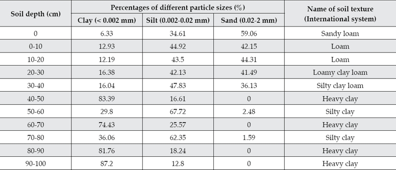
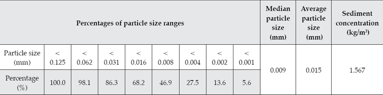
The experimental field is located in Chuhou Township, Yuncheng City. The soil in the field primarily consists of loam and clay, and its complete mechanical composition is displayed in table 1. The uppermost 1 m of soil has an average dry bulk density of 1.4 g/cm3 and a field capacity of 21.4%. Because the properties of sediments carried by the Yellow River vary across regions and seasons, the water diverted from the Yellow River in this study was analyzed to determine the composition of the sediment (see table 1) prior to the irrigation experiment.
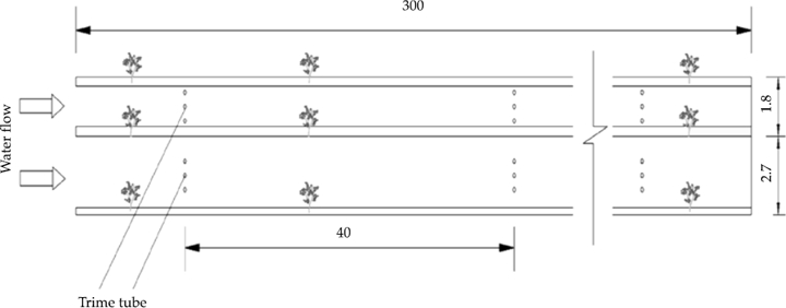
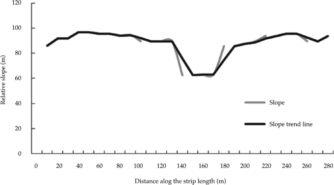
The experimental field includes a narrow strip with dimensions of 1.8 × 300 m and the other with dimensions of 2.7 × 300 m. These are typical dimensions for the Zuncun irrigation area. Fruit trees are planted on the borders, and the areas between the borders are irrigated using the traditional border-strip irrigation technique. Figure 1 illustrates the layout of the experimental field. Before the experiment, the slope of the field along the strip length was measured using a leveling instrument, and the average slope was calculated to be 1/1000.
Experimental methods
After the preliminary work was complete, water diverted from the Yellow River was applied to the field on June 19 and July 30, and relevant experimental parameters were determined. The rate of inflow was measured using a Parshall flume. The bottom of the Parshall flume were covered with sediments, which was swept by a broom, and rinsed off thoroughly with water when the irrigation event was done. Specific parameters and methods used in the experiment are as follows:
During the experiment, marker posts were set up along the length of the strips at intervals of 10 m. The time required for irrigation water to cover the majority of the surface around each post was recorded using a stopwatch, in order to determine advance time.
Monitoring points were designated along the length of each strip at intervals of 40 m. Three Trime tubes were embedded in the soil at each point to monitor variations in soil water content within the soil profiles (see figure 1). Soil samples were collected two days before irrigation, and two days and five days after irrigation. Then time-domain reflectometry (TDR) was used to determine the volumetric water content within the soil profiles at the monitoring points at depths from 10 to 100 cm. The TDR was calibrated three times, compared with oven dry method for soil water content, during the experimental period. Every steps as follow: insert the TDR probe and the soil auger into soil and let them stay parallel, meanwhile measure the TDR and the soil moisture content. And choose three different time periods when the soil moisture content is different, such as 2 days before irrigation, 2 days after irrigation, 15 days after irrigation. The relation curve was obtained between soil moisture content and soil depth calibration.
-
The advance rate and settling speed of sediment in the irrigation water were measured during and after irrigation. The specific procedures are as follows:
Before irrigation, pieces of double-layered gauze (10 × 20 cm) were positioned on the surface of the strips at intervals of 40 m along their length. After irrigation, the sediment accumulated on the gauze was weighed and then taken to the laboratory for particle size analysis.
During irrigation, water samples were collected at the outlets of the water pipes and from locations 0 m, 40 m, 120 m, 200 m, and 280 m from the top end of each strip. Then the concentration and particle size distribution of the sediment in the water samples were analyzed.
Two days after irrigation, undisturbed soil samples were collected from the strips at intervals of 40 m along their length, and their dry bulk densities were measured.
Calculation methods
In existing research, settling velocities of sediment particles are typically calculated using empirical formulas, and various calculation methods are available. Existing comparative studies (Fan et al., 2012; Li, He, Zhu, & Huang, 2014) point out that the formula obtained by Weiming Wu (Wu & Wang, 2006) through an intensive regression analysis of the settling velocity of irregular particles, as well as the formula used to calculate the probability of incipient motion of sediments are commonly used and can produce satisfactory results. The calculation and analysis performed in this study suggest that introducing a shape factor into Wu’s formula can yield a universal formula for determining settling velocity, but the method proposed by Fan, Zhong and Wu (2012) is more applicable to the case of sediment in irrigation water diverted from the Yellow River. In this study, a settling velocity calculation was performed to verify Fan’s method. A comparison of the calculation results with the measured data suggests that water flow over the strips can be simplified to open-channel flow. The relationship of the settling velocity of particles to the Shields number and other parameters can be expressed as follows:
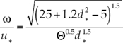 (1)
(1)
where the Shields number is given by Θ = ΔhJ/D, in which h is water depth,  , J is the slope of water surface, and D represents dimensionless particle size. In Δ = (ρs - ρ)/ρ, ρs is the sediment density, ρ is the fluid density, g is gravitational acceleration, and v is the fluid’s kinematic viscosity.
The friction velocity of a fluid is normally calculated using the equation,  where J denotes the hydraulic slope, H is water depth, and g is gravitational acceleration (Liu, Li, & Wang, 2005).
Results and analyses
Analysis of advance rate of irrigation water
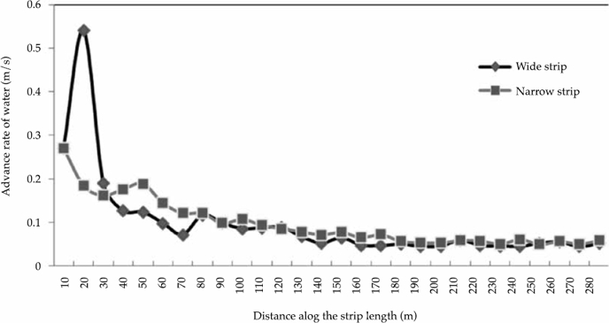
As figure 3 shows, the advance rate of water flow over the field gradually decreased along the strip length. The advance rate over the first 80 m of the narrow strip was significantly higher than the rate over the same section of the wide strip. The water underwent a rapid increase in advance rate as it flowed over the section of the wide strip between 10 and 20 m, as is evident from the high slope on this section of the graph. No significant difference in advance rate was found between the wide and narrow strips after the water advanced over 200 m.
Distribution of sediment on the strips
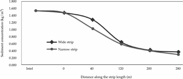
As figure 4 shows, the sediment concentration in the irrigation water declined as the water moved forward over the two strips, with the result that the sediment concentrations were significantly higher at the top ends of the strips than at the bottom ends. The decrease in sediment concentration was sharp over the 0 to 120 m section of each strip, while it was relatively slower over the 120 to 180 m section, indicating that the majority of the sediment carried by the irrigation water settled at the top ends of the strips. This pattern of variation was especially marked on the narrow strip, a finding that can possibly be attributed to the higher flow rate and thus the higher sediment concentration in the irrigation water at the top end of the narrow strip.
Particle size distribution of sediment in water flow over the strips
Figures 5 and 6 show that the particle sizes class of sediments carried by the irrigation water largely fell within the range of 0.004 to 0.016 mm, while coarse and fine particles accounted for only small fractions of the sediments. The concentration of coarse particles was higher at the top ends of the strips than at the bottom ends, while the concentration of fine particles was higher at the bottom ends than at the top ends. This suggests that coarse particles settled out of the fluid earlier than fine particles, with the result that the slower-settling fine particles advanced further with the water flow. The irrigation water at the bottom ends contained more sediment particles ranging from 0.001 to 0.008 mm in size than the water at the top ends, because parts of the surface sediment that had settled on the strips were scoured away by the moving water. Further analysis and research is needed to find out why particles in this size range were mobilized by the water flow.
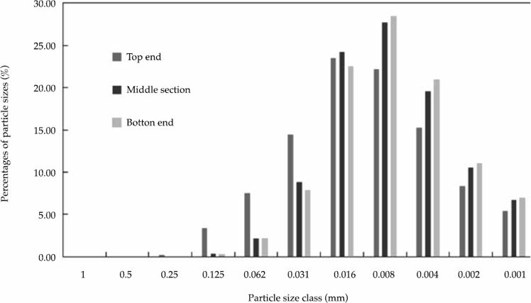
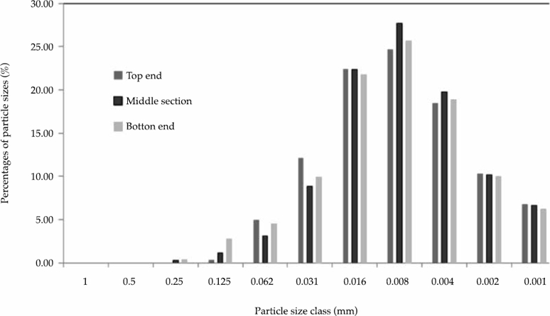
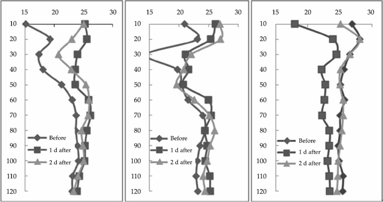
Figure 7 shows the variations in soil water content before and after irrigation at three monitoring points on each strip, located at the top end, middle section, and bottom end. Before irrigation, the water content in the topsoil was about 20%, indicating a need for irrigation. Meanwhile, soil deeper than 60 cm varied slightly in water content, roughly around 23%. On the first and second days after irrigation, the topsoil exhibited marked increases in water content. At the three monitoring points, the overall soil water content on the first day after irrigation was very close to the water content on the second day after irrigation. The topsoil’s water content increased more than 5% compared to the level before irrigation, and the deeper layers also demonstrated noticeable increases in water content. Differences were noted between the soil water contents on the first and second days after irrigation, despite their similar overall trends. For example, in the top and middle sections, the water content in the deep soil layer was slightly higher on the second day after irrigation than on the first day; at the top end, however, the topsoil water content on the second day after irrigation was significantly lower than that on the first day. This result occurred because the water at the top end nearly disappeared as it advanced to the middle and bottom of the strips.
Analysis of settling velocity
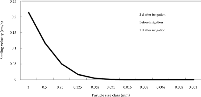
Based on the sediment particle size class distribution in the irrigation water, the settling velocities of particles of different sizes were calculated using the formula presented in Section of Calculation methods. The settling velocity was found to be affected primarily by the sediment’s density and particle size, water temperature, water depth, and strip width. The density of the sediment did not change as the irrigation water moved forward. After the water was channeled to the field, the water temperature tended to remain stable, rendering its influence on the water flow negligible. The water depth and the strip’s slope changed a lot during the advance of the irrigation water, and water depth also affected the friction velocity of the flow  and the Shields number (Θ = ΔhJ/D). Water depth in the formula canceled out during the formula derivation, implying that it has no influence on settling velocity. However, the strip’s slope varied significantly along the strip length and the slope variation was closely correlated with the settling velocity. Ultimately, particle size was the main factor affecting the settling velocity of the sediment in the irrigation water: The settling velocity decreased as the particle size decreased.
Conclusions
During the border-strip irrigation experiment, the amounts of settled sediment varied significantly from the top ends of the strips to their bottom ends. The amounts of sediment settled at the top ends of the wide strip and narrow strip were, respectively, 4.2 times and 5.3 times the amounts settled on the bottom ends. The advance rate of the sediment also changed significantly from the top end to the bottom end of each strip, indicating that the advance rate was affected not only by the strip’s slope, but also by the flow rate and infiltration of water into the soil.
The amounts of deposited particles decreased along the strip length from top to bottom. The decrease was especially marked on section of each strip between 40 and 120 m.
The particle size distribution of the sediments deposited along the strips accords with the law of sedimentation; coarse particles accumulated primarily at the top ends as a result of high settling velocity. The existence of coarse particles in the sediment at the bottom ends suggests that the advance of irrigation water was a relatively complex process associated with the scouring action of the water flow on the surface particles deposited on the strips. Further research is needed to explore this issue.
It was feasible to represent the water flow over the strips as open-channel flow when calculating the settling velocity of the sediment particles. However, the formula for calculating settling velocity requires further modification to take into account the influences of flume rate as well as the scouring action of the moving water on the surface sediment deposited on the strips.

