


 nueva página del texto (beta)
 Inglés (pdf)
 Artículo en XML
 Referencias del artículo
 Enviar artículo por email
 Citado por SciELO
  Similares en
SciELO
Similares en
SciELO 
 Permalink
Introduction
In Mexico, the mean annual amount of water availability per capita is only 4 263 m3 (this and other statistics were taken from EAM, 2014), ten times less than Brazil (42 886 m3) and 10 and 15 times less than other sister countries, such as Peru (66 338 m3), Bolivia (64 215 m3), Chile (54 868 m3) or Colombia (47 365 m3). Availability of water per inhabitant, as often happens, has strong spatial variations. For example, in the states in southwestern Mexico there is more than 20 000 m3 per inhabitant per year, while in the Valley of Mexico, the most populated region of the country, annual availability per person is just over 140 m3. Figure 1 shows the annual rainfall distribution, which gives a good idea of how water resources vary spatially (the mean annual rainfall for the whole country: 772 mm).

In most of the country the rainy season is from May-June to October-November, and as in many other countries of the world, in Mexico the mean monthly rainfall varies widely throughout the year, so even in some humid areas such as in the south and southeast of the country there are periods when irrigation is needed to increase the crop yield.
This situation has made irrigation necessary since prehistoric times to satisfy the needs of different crops. Table 1 shows a summary of the main water infrastructure build in México until 2013.

Today, Mexico has approximately 6.4 million hectares under irrigation; of these, 3.4 million are located within 85 irrigation districts, which have an average area of 41,059 ha; the other 3 million ha are found dispersed in more than 39,000 irrigation units, that is, small areas averaging only 76 ha. This makes it very difficult for government organisms to give them adequate attention. To complete the picture, we must add that all of the water used for irrigation (62 km3), a third (21 km3) comes from the 653 aquifers in which our country has been subdivided. Of these, 104 are overexploited and many have high contents of soluble salts. Irrigation is essential for Mexican economy because the yield of irrigated crops is from 2.2 to 3.3 times that of rain fed agriculture.
Among the main problems that irrigation faces in Mexico in present day, we can mention:
The lack of awareness of the real value of water, on the part of both the different water users and the authorities, which is manifested in inefficient use of this resource in both agricultural areas and cities.
Over-exploitation of surface currents; the ecological flow is not being respected and many small streams are no longer permanent. Moreover, the quality of the natural currents has deteriorated as a consequence of dumping urban sewage water into the streams with no treatment whatsoever.
Over-exploitation of many aquifers; bans are not respected, and there are many clandestine wells drawing water for agriculture as well as for other uses.
Salinization of irrigated soils, which reduces crop productivity, is caused by elevation of water tables and by use of water with high soluble salt contents.
Furthermore, these problems are expected to become acute as a result of global climate change. The predictions of climate change in Mexico have been pronounced by two leading groups of researchers; at The Center for Atmospheric Sciences (CCA) of the National Autonomous University of Mexico (UNAM) (Gay, Conde, & Sánchez, 2006; Magaña, 2010) and the Mexican Institute of Water Technology (IMTA) (Martínez-Austria & Patiño-Gómez, 2010). Their studies have considered several scenarios of CO2 emissions, such as those denominated A1B, A2 and B1 (in the case of the studies conducted by CCA UNAM) and A1B and SRES-A2 (in the studies of IMTA). Also, several global climate models developed in different countries around the world have been used. The results of these studies predict that by the middle of the twentyfirst century, we can expect:
A reduction of 10 to 30% in mean annual precipitation.
2.3 ± 1.0 °C higher air temperatures.
An increment of up to 10% in the potential evapotranspiration rate.
This will cause a 20 to 40% reduction in water available for irrigation, and this, in turn, will cause the area affected by salinity to increase from the present 10 to 15% to 20 to 30% or more of the country's irrigated area. This trend also corresponds approximately to the growth in area where it will be necessary to install field drainage systems.
This paper presents an overview of the principal actions that have been taken in the irrigation districts of Mexico to diagnose, monitor and partially solve problems of high water tables and soil salinity. These actions are grounded in the idea that salinity of irrigated soils in arid and semi-arid regions have two main causes: 1) elevation of saline water tables up to 1.5 m or less from the surface; this in turn is due to diverse losses of irrigation water, in both conveyance and distribution in unlined channels and deficient application of irrigation in the fields (called "secondary salinization"), and 2) the use of water with high soluble salt contents ("primary salinization", in general less frequent than secondary). A detailed description of the complex processes that lead to accumulation of salts in the topsoil is not within the scope of this paper. The parting premise, simplified but correct, is that the best way to prevent or combat the problems of salinity in the long term is reducing water losses, that is, improving conveyance efficiency by lining the channels (or installing tubes when it is economically possible), improving irrigation efficiency, and installing underground drainage tubes in those areas where the (saline) water tables are close to the surface and cannot be lowered by other means.
A Little History of the Modernization of Irrigation In Mexico
It can be said that modernization of irrigation and studies monitoring water table levels and soil salinity begin formally in Mexico in 1962, with the creation of the Offices of Irrigation and Drainage Engineering (known as "IDRYD" for their initials in Spanish). These works were started first in the irrigation districts being rehabilitated at that time (Culiacan, Sin., Valle del Fuerte, Sin., Río Mayo, Son., and Río Yaqui, Son.), and later in the country's major irrigation districts. The purpose of these offices was to give technical support to these rehabilitation works (SARH, 1976).
Amaya-Brondo and Robles-Espinosa (1963) define the functions of these offices in the following manner: "The functions of the offices of Irrigation and Drainage Engineering are to conserve soil and increase production in Mexican irrigation districts through the most efficient use of water and soil, on the part of both the Irrigation District and the individual user". The authors note that the intention of the authorities of the Ministry of Water Resources was that these offices be "permanently established in the irrigation districts as an important part of their functional organization". Given the enormous differences in yearly precipitation (See Figure 1), topography, soils, climate, crops, etc., for supervision and control of the IDRYD offices, the country was divided into two large zones: the Northern Zone and the Southern Zone, divided at approximately Parallel 24º North Latitude.
Amaya-Brondo and Robles-Espinosa (1963, 1964) describe in detail the multiple functions posed for the IDRYD offices, beginning with updating agrological studies using the most advanced methods at that time, aerial photographs and photointerpretation, and particularly taking into account the salinity conditions in the Northern Zone, where scarce atmospheric precipitation promotes accumulation of salts in the soils. The activities of the IDRYD offices not only encompassed the definition of optimal depths and irrigation scheduling for the main crops, but also improvement of irrigation water management efficiency both in the conveyance and distribution network and in field application and other aspects of agricultural production. The IDRYD offices also calculated land leveling and made recommendations to achieve better efficiency in applying irrigation water.
Significant progress in modernizing irrigation occurs in 1967 when the "Plan de Mejoramiento Parcelario" (Plan for Plot Improvement), better known by its acronym "Plamepa" was created (Pasos, 1985). This plan comprised two types of activities: first, improvement of operation and distribution of water, and second, technical assistance for farmers so that better use of water in their fields would increase irrigation efficiency and productivity of their land. This assistance was carried out in the irrigation sections where there was less efficient water use, according to the hydrometric studies conducted. The plan was inter-institutional and called for the participation of the Ministry of Agriculture, particularly the National Institute of Agricultural Research, to make recommendations, not only on irrigation techniques, but also on agricultural technology in general for the main crops.
Amaya-Brondo (1970) pointed out that "by achieving better efficiency in water management and use, 20% of wasted water could be recovered, considering this a realistic goal in the current conditions of development of the districts, a goal that can be reached without the need to line the canals. This recovery percentage would be integrated as follows: raise conveyance efficiency by 50% of that estimated in the 1965-66 crop cycle, and water use efficiency in the plot from 50 to 70%, with which total efficiency, estimated at 25% at that time, would increase to 45.5%, that is, the targeted 20%. It was also reported that this apparently modest goal would make it possible to irrigate 500,000 additional ha". History would show that these estimations were very optimistic. However, an additional benefit, well understood by irrigation and drainage specialists, was that reducing irrigation water losses would necessarily be reflected in a reduction in recharging water tables and, therefore, in lowering them. With this, conditions of soil salinity would also improve.
Plamepa received new impetus in 1972 when a loan to reinforce the program from the Inter-American Development Bank (BID) was signed. The original plan considered two stages, with a total cost of 61.6 million dollars. However, only one part equivalent to 47 million dollars was executed. Through this program, over an area of more than a million hectares, topographic maps of the irrigated fields were made, to better place and orient irrigation furrows in the plots, using what was known as "irrigation recipe". Also, a large number of "demonstration plots" were set up, in which irrigation techniques were tested on the main crops; 14,387 gauging structures were built for delivery of irrigation water by volume; 340.5 km of canals were lined; laboratory equipment was acquired and a large number of engineers and technicians were trained. Unfortunately, Plamepa was unexpectedlysuspended in 1977.
It should be pointed out that the IDRYD offices directed their activities primarily toward improving irrigation techniques and agricultural productivity, leaving the study of salinity and drainage problems in second place. However, it is important to have in mind that improvement in conveyance and application of irrigation water, in the end, is also reflected in improvement of soil drainage and salinity conditions.
Monitoring Water Table Levels and Soil Salinity
Phreatimetric Studies
Monitoring phreatic levels used to be done from 4 to 12 times a year, by direct measurement (with an acoustic probe) of the depth of levels in a network of observation wells (fortified with 1 3/4 - 2 inch PVC tubes) around 3 m deep with a density of 1 well every 100 to 400 ha. The network of observation wells was completed over several years since the cost of each well made it difficult to construct the entire network in a single year. However, the most costly and complex operation on the long term was the systematic measurement of phreatic depths, besides replacement of damaged wells. As a general rule, it was recommended that measurement be done over one or two days. For this reason, in some of the districts all of their technicians would participate, even those from other technical sections of the irrigation district (Amaya-Brondo & Robles-Espinosa, 1963). In other cases, there was a single brigade that was responsible for taking the measurements, who, in the larger districts (with more than 200,000 ha), would take around two months.
These measurements were represented graphically on maps drawn by hand since plotters were scarce at that time. Two types of maps were drawn: iso-depth (isobaths) and isoelevation (isobars) of the phreatic levels. These maps were very similar to the topographic contour line or isohyet maps.
Using the isobaths maps, it is possible to identify the most affected areas, while the isobar maps (which, in a certain way, are equipotential lines) allow identification of the main directions of the phreatic currents. This information was used to design the networks of drainage collectors.
Iso-depth maps would often be summarized in an "areas-time" graph, which allowed observation of how the areas with different ranges of phreatic level depth varied over the year and over several years. Figure 2 shows an example of this type of graph information, for the Irrigation District No. 41, Río Yaqui, Son.
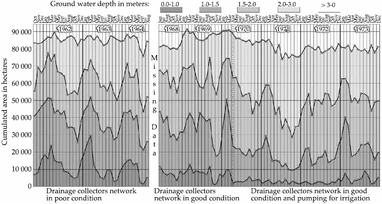
Figure 2 Detail of an "Areas-Time" graph, where both intra-annual and inter-annual ariation can be observed in areas with different depth range of the phreatic level.
It can be seen that these maps allow "taking the pulse" of the irrigation district, in terms of problems with phreatic levels. They reflect the principal changes that occurred in phreatic levels as a consequence of activities such as rehabilitation works, entry into operation of wells for pumping underground water, improvements in irrigation and drainage systems, etc. In the graph in Figure 2, it is quite clear how areas with the shallowest phreatic levels decreased (shaded in dark gray) as of April 1970, when a network of wells began pumping underground water, showing its enormous effect as "vertical drainage". Statistically, these graphs were very "robust", since they were constructed from a large quantity of information. Complemented with information on precipitation, derivations for irrigation, extraction from the aquifer, etc., these maps permitted assessment of both the principal components of the water balance and the state of the district's soils. It is a real pity that such graphs are no longer being produced in our irrigation districts.
Soil Salinity Studies
Soil salinity was determined initially on socalled "apparent salinity maps" for which no soil samples were taken nor were chemical analyses conducted. These maps were constructed on the basis of reductions in agricultural productivity of the major crops under the assumption that salinity was the main factor in reducing crop yields. In these maps, four types of saline affectations are differentiated, estimated in function of the observed reduction in agricultural yields:
Not affected by salinity,
Slightly affected (reduction of 10 to 15% in mean yield)
Intermediately affected (reduction of 15 to 30% in mean yield), and
Strongly affected (reduction of more than 30% in mean yield).
The minimum differentiable area was "one plot" (or the part of it planted with a single crop), generally of a few hectares in area.
By 1964, it was estimated, that for the four districts where these studies were initiated (Culiacán, Rio Fuerte, Río Mayo and Rio Yaqui) with a total area of 610,701 ha, 36% of their land exhibited some degree of affectation by salinity, from slight to land abandoned due to the high degree of affectation (Amaya-Brondo & Robles-Espinosa, 1964).
Only in the most affected parts "analyzed salinity maps" were constructed on the basis of sampling several soil layers (typically 0-30 cm, 30-60, 60-90, 90-150, 150-210 and 210-300 cm) and of determinations of not only electric conductivity of the saturation extract, but also of the main anions and cations.
Quantification of "saline" areas in an irrigation district depends basically on the criterion for defining a "saline" soil. Towards the middle of last century, the Salinity Laboratory of the Department of Agriculture of the United States published the well-known Manual 60 "Diagnosis and rehabilitation of saline and sodic soils" to serve as a practical guide for summarizing information on soil "salinity" and "alkalinity". Four large groups of soil were differentiated in function of two parameters: electric conductivity (EC) of the soil saturation extract, according to whether it was higher or lower than 4 mmho/ cm, and the "sodium adsorption ratio" (SAR), according to whether it was lower or higher than 15%. A soil was considered "normal", with no problems of salts, if it had an EC below 4 mmho/cm and an SAR below 15%. The soil was "saline" if it had an EC above 4 mmho/cm and an SAR below 15%. And it was "sodic" if the EC was below 4 and SAR above 15%. These soils are more difficult to recover because they require amendments. The rest of the soils are "saline-sodic". Applying this criterion, a large part of the irrigated soils in arid regions would be classified as saline. For this reason, though not generally, other classifications were established based on different ranges of the electric conductivity value of the saturation extract of the soil samples. Thus, De la Peña established the following soil classes in terms of salinity (Llerena-Villalpando, 2011):
First class, below 4 mmho/cm (no saline affectation).
Second class, 4 to 8 mmho/cm (slightly affected).
Third class, 8 to 12 mmho/cm (intermediately affected).
Fourth class, 12 to 20 mmho/cm (strongly affected).
Fifth class, above 20 mmho/cm (very strongly affected).
In characterizing soil salinity, another problem, with no clear and general solution, was determining the "appropriate" sampling density, which largely depended on the magnitude of the area and the purpose of the study, since it is not the same thing to sample a 20 ha plot with problems of salinity aiming to conduct a soil leaching operation as to sample an entire irrigation district of several tens of thousands of ha to simply construct a generic map of soil salinity. Reliable knowledge of the contents and distribution of salts in the soil is essential for correct planning of leaching saline soils using the least possible amount of irrigation water, an unavoidable rule in the measure that the water crisis becomes more acute.
One of the first attempts to define sampling intensity for the purpose of leaching saline soils taking into account the cost of water, the cost of soil sampling and chemical analyzes, as well as the cost of losing the crop if the land was under-leached, was undertaken by Llerena-Villalpando and Palacios-Vélez (1979), who arrived at the conclusion that, for the conditions of that time, it was necessary to take at least one sample per hectare.
Regarding the method of interpolation of soil salinity data, necessary for saline soil cartography, Ramírez-Ayala, Palacios-Vélez and & Zárate-de-Lara (1979) compared the Kriging interpolation method with certain trend functions for three series of data corresponding to different spatial scales. The smallest study area had salinity data determined on a grid of 17 x 17 sites only 1.25 m apart. A second series of data comprised 97 sites spaced 40 m apart. Finally, a third scale had 395 sites located irregularly with a mean spacing of 2 700 m, but fluctuating between 900 and 20 000 m. As we know, the Kriging method is based on the initial definition of a semi-variogram. On this point, the first series of data, spaced 1.25 m, obtained a linear semi-variogram that did not define a radius of influence where the semi-variogram is equal to the variance. In the second series of data, with equidistant spacing of 40 m, a fit to a spherical semi-variogram was obtained with a radius of influence between 200 and 260 m. Finally, in the third series of data, with irregular spacing of a mean of 2 700 m, a variability of data too broad to define a variogram was obtained. This work evidenced the need to study scales intermediate between 40 and 2 700 m. It is also important to study the reliability of the different available methods of interpolation since the reliability of the constructed maps depends upon it.
Regarding the leaching and recovery of saline soils, it must be said that this type of study has been conducted in few places in Mexico, besides the Irrigation District Num. 41 Rio Yaqui, Sonora, since the operation requires using irrigation water without obtaining a harvest during the period of rehabilitation of these soils.
Some of the main points to consider when planning the recovery of saline soils by leaching are:
Define the appropriate sampling density to determine more reliably the degree of salinization of the soil and to define correctly the amounts of water required for leaching (and the amount of amendments, if they are necessary).
Obtain maps of salt distribution in the plots to be recovered, aiming to apply differential leaching to save water (which can be called "precision leaching").
Begin farming the recovered plots with salttolerant crops since recovery continues with over-irrigating.
Maintain phreatic levels in recovered plots at depths of more than 1.5 m to prevent the return of salts to the upper part of the soil by using underground drainage if necessary.
The Decline of the IDRYD Offices
The IDRYD Offices began to receive less support during the 1980s and disappeared during the early 1990s. The Mexican authorities, primarily concerned with decreasing government expenses as much as possible, considered that the IDRYD Offices were not indispensable and that each farmer should cover the costs of the studies done in his plot.
In an attempt to make an objective assessment of the activities of the IDRYD Offices, it has to be said that a large part of their work did not go beyond recommendations and good intentions. The country did not yet have (nor does it have today) the conditions that would make decided combat against any kind of irrigation water loss not only possible but also economically attractive and even essential, something that would require a substantial increase in the cost of water. It seems impossible that both agricultural and urban users would be willing to make a real effort to conserve this resource if only exhorted without our pocketbooks being directly affected.
Moreover, the adoption of subterranean drainage practices when saline phreatic levels are found above 1.5 m depth and/or when there are problems of soil salinity reflected in decreased crop yields will require government support programs to reduce the effort and investment that farmers have to make.
Current Situation (2014) of Drainage and Salinity Studies
During the late 1980s, most of the irrigation districts were transferred to irrigation users associations (AUR) and, in the most advanced phase of this process, the transference went to societies of limited responsibility (SRL) to manage larger irrigated areas. Before this, the districts were operated by what is now called the National Water Commission (Conagua) through the local offices of the irrigation districts. Today, Conagua only operates large works of hydraulic infrastructure, that is, large dams and the current (National) Management of Irrigation Districts, and has, rather, a normative role. The users associated in "irrigation modules" have the responsibility of distributing the irrigation water, collecting the drainage water, solving internal conflicts, carrying out the operation and maintenance of the structures as well as collecting payments of irrigation fees. Although it has never been openly recognized, one of the reasons for transferring the irrigation districts to the users was more the government's concern for reducing subsidies to the irrigated agriculture sector than its conviction that transferring the irrigation systems to users would improve their operation. Many evaluations have been done on the results of the transfer, but negative evaluations appear to predominate (Trava-Manzanilla, 2010).
After the irrigation districts were transferred, a program of "voluntary retirement" in the irrigation districts was implemented during the early 2000s. As a consequence, Conagua lost a good part of their most experienced technical personnel. This loss was felt adversely in the quantity and quality of the hydrometric, statistical, agroclimatological, production and commercialization information that is generated in the irrigation districts and that is fundamental for their planning, operation and conservation, as well as for any improvement program on the short, medium and long terms.
Thus, as of the late 1980s, making phreatimetric maps practically stopped, although there are a few exceptions, such as Lázaro, Fuentes, Ortega-Escobar, Rendón-Pimentel and Zataráin-Mendoza (2000), who made a prognosis using maps of phreatic depths for different scenarios of soil and water management policies in Irrigation District Num. 076, Valle del Carrizo, Sinaloa. In this study, measurements of 1996 phreatic levels were used; these may have been the last measurements taken in this irrigation district. Likewise, soil salinity studies are no longer conducted, so that it is now not possible to assess precisely the situation of this aspect now existing in the irrigation districts of the country.
Conclusions
In the measure that extraction of underground water has been increasing, phreatic levels have been declining. Figure 2 shows this trend quite clearly for the case of Irrigation District Num. 41, Rio Yaqui, Sonora. Unfortunately, there are no similar graphs for other irrigation districts.
Regarding information on soil salinity, there has never really been an attempt to quantify or generally map the areas with different degrees of affectation. Recently, attempts to monitor soil salinity have been made using LandSat satellite imagery and the electromagnetic sensor EM-38 (Pulido, González-Meraz, Wiegand, Infante-Reyes, & Delgado, 2010). The results, however, do not appear to be very reliable or encouraging because the spectral appearance of the crops do not depend only on saline affectation, and the EM-38 sensor requires greater calibration with data on salinity analyzed in soil.
Several authors have studied saline affectation in irrigated areas of our country. It was Llerena-Villalpando (2011) who has probably achieved summarizing the broadest scope of this information. He concludes that there are around 650,000 ha that are affected to some degree by salinity, equivalent to 10% of the country's irrigated area. Similar figures have been reported for other countries such as 12.8% in China and 11.9% in India (Llerena-Villalpando, 2011). It is of great important to have a precise figure and to indicate ranges of salinity in order to plan and justify measures of prevention and combat against salinization.
With respect to using underground drainage pipes, one of most effective ways to lower saline water tables and promote the leaching and recovery of salinized soils, the country has installed this type of drainage in only about 60,000 ha, that is, only 1% of the country's irrigated area. In is not easy to explain how miniscule this figure is, but possible causes may be among the following: lack of tradition and conviction on the part of the farmers of the goodness of these systems; the recurrent economic crises that have affected the farmers, and the lack of promotion on the part of Conagua and of institutions of higher education and research related to problems of water in agriculture.
Finally, it is hoped that when, in the future, studies on monitoring phreatic levels and soil salinity are again taken up, there will be modern technology for measurement and data transmission as well as perfected soil salinity sensors that would allow in situ measurement of salinity. When all of this information is processed in the form of maps and graphs with the help of geographic information systems and other computer software, costs and time will decrease while the quality of these studies will increase.

