


Services on Demand
Journal
Article
 text in
  English (pdf)
 Article in xml format
 Article references
 Send this article by e-mail
Indicators
-
 Cited by SciELO
 -
 Access statistics
Related links
-
 Similars in
SciELO
Similars in
SciELO
Share

 Permalink
Revista mexicana de ciencias forestales
Print version ISSN 2007-1132
Rev. mex. de cienc. forestales vol.12 n.65 México May./Jun. 2021 Epub Aug 30, 2021
https://doi.org/10.29298/rmcf.v12i65.873
Scientific article
Dendrohydrological reconstruction of streamflow on the Coahuayana hydrological sub-basin, Jalisco State
1Instituto Nacional de Investigaciones Forestales, Agrícolas y Pecuarias. Centro Nacional de Investigación Disciplinaria en Agua, Suelo, Planta, Atmósfera. México.
2Instituto Nacional de Investigaciones Forestales, Agrícolas y Pecuarias. Centro de Investigación Regional Pacífico Centro. Campo Experimental Centro Altos de Jalisco. México.
A dendrochronological network of conifers was developed for the Armeria-Coahuayana basin in southern Jalisco. A principal component analysis showed a common climatic response among the chronologies, therefore, they were integrated into regional representative chronologies of earlywood, latewood and total ring width with a length of 215 years (1800-2014), where the confident period for hydroclimate reconstruction extended from 1860 to 2014. The earlywood chronology had a significant association (r = 0.70, p < 0.01, 1952-2005) with the seasonal January-June gauged records of the Quito gage station located in the Coahuayana sub-hydrological region, Jalisco, and a streamflow model was developed for reconstruction purposes. The streamflow reconstruction showed high- and low frequency variability, where the extreme 1869-1876 drought could occur in coming years in order to take mitigation actions. The winter-spring streamflow in the Quito watershed is significantly influenced by the El Niño Southern Oscillation as corroborated by its association with the January-June SOI index (r = -0.47, p < 0.01, 1952-2014). Its influence is verified with the significant peak (3.21) detected in a power spectral analysis for the earlywood-chronology. Circulatory phenomena as the Pacific Decadal Oscillation showed a significant but comparatively lower association (r = 0.38, p < 0.01) and the Atlantic Multidecadal Oscillation was not significant.
Key words: Conifers; dendrohydrology; El Niño Southern Oscillation; earlywood; Hydrological Region 16; droughts
Se desarrolló una red dendrocronológica de coníferas para la región hidrológica Armería-Coahuayana en el sur de Jalisco. El análisis de componentes principales determinó que las cronologías poseen una respuesta climática común y se integraron en una cronología regional de madera temprana, tardía y anillo total con una longitud de 215 años (1800-2014) y un periodo estadísticamente confiable de 1860 a 2014, con fines de reconstrucción hidroclimática. La cronología regional de madera temprana mostró una respuesta significativa con los registros del gasto acumulado enero-junio (r = 0.70, p < 0.01, 1952-2005) de la estación hidrométrica Quito, subregión hidrológica Coahuayana, Jalisco. Esta se utilizó para desarrollar una reconstrucción de flujo, la cual presentó alta variabilidad interanual y multianual de escurrimientos, en la que la sequía más extrema (1869 a 1876) puede considerarse como un período de escurrimientos con posibilidad de ocurrir en el futuro e implementar acciones de mitigación. La precipitación invierno-primavera y por ende los escurrimientos en la cuenca Quito evidenciaron influencia del fenómeno del Niño Oscilación del Sur, como lo indica su asociación con el índice SOI enero-junio (r = -0.47, p< 0.01) y picos significativos de 3.21 años, con el análisis espectral en la frecuencia de este fenómeno. Otros eventos circulatorios, como la Oscilación Decadal del Pacífico registró un efecto significativo, pero menor (r = 0.38, p < 0.01); mientras que, la influencia de la Oscilación Multidecadal del Atlántico no fue significativa.
Palabras clave: Coníferas; dendrohidrología; El Niño Oscilación del Sur; madera temprana; Región Hidrológica 16; sequías
Introduction
The demand for water resources in Mexico increases annually according to population growth (Conagua, 2018). This demand is not coupled with the supply of these resources, due to modifications in the hydrological cycle derived from changes in land use and global warming problems, which, according to general circulation models, will produce significant reductions in precipitation by 2030 (Riva, 2015). The volume of water per capita in the country has decreased; in 67 years (1950-2017), availability fell 79 %, from 17 742 to 3 656 m3 inhabitant-1 year-1 (Conagua, 2018).
The quantitative assessment of water resources is a difficult task to complete, particularly from the limited network of climatic and hydrometric stations and their short length and quality of data, which limits making inferences about their historical behavior and trends. In this regard, tree rings constitute a high-resolution “proxy” to analyze the interannual and multiannual climate variability (Woodhouse et al., 2006; Martínez-Sifuentes et al., 2020), since, in their bands of annual growth, the prevailing environmental conditions during its development are recorded (Schweingruber, 1996).
Dendroclimatic reconstructions, particularly hydrological reconstructions in western Mexico, are very limited (Villanueva et al., 2012; Cerano et al., 2013), but show the potential for the development of extensive series, which can contribute to understanding the variability interannual and multiannual of the climate and the influence of climatic forces, which impact the availability of water resources for productive purposes and for human consumption (Villanueva et al., 2017).
The production of water in the south-southwest portion of the state of Jalisco impacts the well-being of human settlements located in the border area of the states of Jalisco, Colima and Michoacán, which depend on the water produced in hydrological regions such as Armería-Coahuayana (INEGI, 1995; INEGI, 2000). In this way, the objective of the present study was to generate a network of series of growth rings distributed in the Armería-Coahuayana hydrological region (RH16) and to develop a reconstruction of the runoff produced in the Coahuayana basin of the state of Jalisco, whose volumes of flow are recorded at the Quito and San Gregorio hydrometric stations. The hypothesis of the research is that the dendrochronological series in RH16 show a common climatic signal and that, when integrated into a series of regional growth, they will allow the estimation of flow volumes that occurred in this hydrological region to be extended into the past.
Materials and Methods
Study area
The Armería-Coahuayana hydrological region is located in the south of the state of Jalisco in the Eje Neovolcánico and Sierra Madre del Sur provinces; in Jalisco it covers an area of 12 581.5 km2, which represents 15.70 % of the state's total. The region's climate is warm subhumid with subtypes AW0 and AW1 (w) summer rains (García de Miranda, 1989). Precipitation in the region varies from 800 to 1 200 mm per year, with an average temperature of 24 to 26 °C (INEGI, 2000). This hydrological region is made up of the Coahuayana and Armería rivers subregions, which drain into the Pacific Ocean.
The Coahuayana river subregion is made up of four hydrological basins, Quito, Coahuayana-Jalisco, Coahuayana-Colima and Coahuayana-Michoacán with a total area of 7 895 km2; it is located south of Jalisco and extends towards Colima and Michoacán. In the state of Jalisco, it covers an area of 4 487.6 km2, which is equivalent to 5.60 % of its surface. The precipitated volume in the Coahuayana basin is 3 383 million m3 (Mm3), of which 281.0 Mm3 drain (INEGI, 2000).
Dendrochronological sampling and dendrohydrological reconstruction
For the generation of dendrochronological series, various sites were selected in coniferous forest communities, in the upper parts of the basins of the RH16, corresponding to the state of Jalisco; the selected sites were: Autlán de Navarro (AUT); Gómez Farías (GFA), Sierra de Quila (SQU), Terrero (TER), Tuxpan (TUX) and Bosque La Primavera (BLP) (Figure 1).
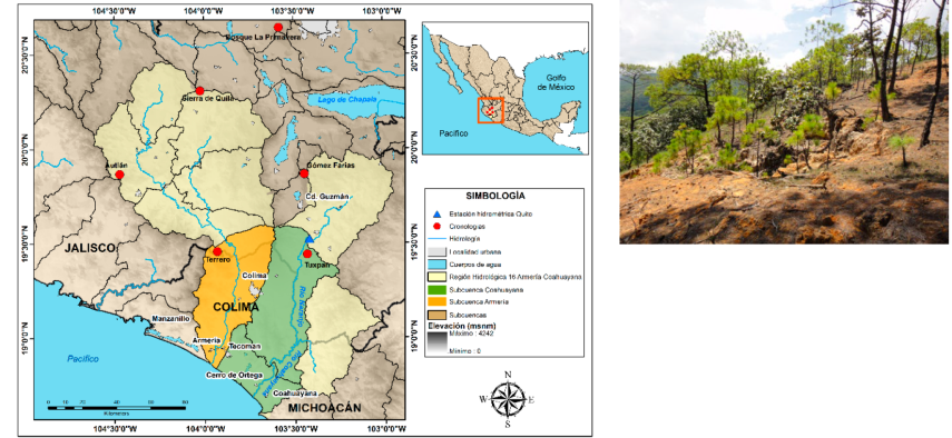
Figure 1 Distribution of sites sampled for the development of dendrochronological series in Hydrological Region 16 Armería-Coahuayana in the state of Jalisco (left) and site condition in a coniferous stand in Bosque La Primavera (right).
Sampling included several pine species, such as Pinus douglasiana Martínez (Pdou), Pinus oocarpa Schiede ex Schltdl. (Pooc), Pinus devoniana Lindl. (Pdev), Pinus lumholtzii B. L. Rob. & Fernald (Plum), Pinus durangensis Martínez (Pdur), Pinus maximinoi H. E. Moore (Pmax) and Pinus pseudostrobus Lindl. (Ppse), which makes it possible to capture more accurately the hydroclimatic variation that characterizes this area (Table 1).
Table 1 Geographic location of the collection sites and species sampled in the hydrological Armería-Coahuayana 16th region.
| Site | North latitude (degrees) | West longitude (degrees) | Altitude (m) | Species |
|---|---|---|---|---|
| AUT | 19.614 | 104.251 | 1 910 | Pdou, Pooc, Pdev, Plum |
| GFA | 19.869 | 103.395 | 2 202 | Pdur, Pmax |
| SQU | 20.300 | 104.064 | 2 029 | Pdou |
| TER | 19.457 | 103.929 | 2 401 | Ppse |
| TUX | 19.441 | 103.428 | 1 440 | Pooc |
| BLP | 20.645 | 103.586 | 1 821 | Pooc |
At each site, 30 to 50 trees were selected. The dendrochronological samples were obtained with a Pressler's bit and in each tree, two to three increment cores were extracted at breast height (1.35 to 1.40 cm). The number of total increment cores extracted per site was 90 for AUT, 87 for GFA, 130 for SQU, 90 for TER, 120 for TUX, and 150 for BLP.
The samples were processed according to conventional dendrochronological techniques (Stokes and Smiley, 1968) and with a Velmex measurement system, 0.001 mm precision (Robinson and Evans, 1980), measurements of both the total ring width were obtained. The dating quality was performed by using the COFECHA program (Holmes, 1983) and the total ring width, was standardized with the ARSTAN program, a negative exponential curve, positive, stright lines with negative or positive slope, and a spline that conserves 50 % of the variance (Cook, 1987), which produced three versions of the chronology, standard, residual and arstan.
In order to analyze the common variance between the dendrochronological series, a Principal Component Analysis (PCA) was run and based on the first principal component; the sites to be integrated into a measurement database were defined and a regional chronology was generated, where the useful length of the chronology for reconstruction purposes was determined based on the Expressed Population Signal (EPS) with a value ≥ 0.85 (Wigley et al., 1984).
From the National Bank of Surface Water Data of the National Water Commission (Bandas), the records of the hydrometric stations present in the RH16 were downloaded with the following codes: 16041 Quito (18.525o N, 103.417o W), 6020 El Nogal (19.892o N, 103.8o W), 16021 San Gregorio (19.834o N, 103.35o W), 16031 Canoas (19.525o N, 103.884o W) and 16033 El Rosario (19.667o N, 103.992o W). The runoff volumes produced in the Coahuayana basin are recorded at the Quito and San Gregorio hydrometric stations; while the volumes of the Armerías river in the Canoas, El Nogal and El Rosario hydrometric stations.
The hydrometric records at the monthly and seasonal level were normalized by transforming them to base 10 logarithms and, later, they were compared with the regional dendrochronological series of earlywood, latewood, and total ring width in their standard and residual versions; this generated a model for an individual or combined hydrological station for the reconstruction of runoff volumes.
The available hydrometric records were calibrated both in the total length of the period and in two sub-periods, corresponding to half of the records; the verification was carried out in half of them, through the Library of Dendrochronological Programs of the University of Arizona (DPL), with the “Verify” subroutine.
The statistically calibrated and verified regression equation was used to reconstruct the seasonal runoff volumes, to which a flexible decadal spline was fitted to highlight low-frequency events (Cook and Peters, 1981).
The presence of years or periods with low or high seasonal runoff present in the reconstruction was determined based on the value of the median ± 0.5 of the standard deviation, in which the values above this parameter are classified as wet events and underneath, as dry events.
The significant frequencies in the regional dendrochronological series and, therefore, in the runoffs, were calculated by means of a Power Spectral Analysis (Wilks, 1995), carried out with the Library of Dendrochronological Programs in “R”, version 1.6.7 (Bunn et al., 2018).
The interannual and multiannual variation of the climate in Mexico is influenced by various ocean-atmosphere phenomena. In this study, to determine the best relationship between the regional chronology of earlywood, latewood, and total ring width and ocean-atmosphere phenomena, the best association of these chronologies with indices of El Niño Southern Oscillation (ENSO, for its acronym in English) through the Southern Oscillation Index (SOI) reconstructed in the period from previos November to February of the current growth year (Stahle et al., 1998) and the Multivariate Index (MEI) (Wolter and Timlin, 2011); as well as with indices of the Pacific Decadal Oscillation (PDO, for its acronym in English) (Mantua et al., 1997) and the Atlantic Multidecadal Oscillation (AMO, for its acronym in English) (Enfield et al., 2001).
The presence of wet and dry events in the reconstruction was verified with documented historical data of droughts, wet periods, food production and existing dendroclimatic reconstructions (Cerano et al., 2013; Domínguez, 2016; Ortega-Gaucín, 2018; Villanueva et al., 2018).
Results
The extension of the dendrochronological series was different between sites, the most extensive of which was that of Autlán de Navarro (1800-2014) and the shortest that of Terrero (1935-2015). The intercorrelation between series exceeded the critical value of 0.328 (p <0.01) for an adequate dating and the average sensitivity indicates that the series have potential for hydroclimatic reconstructions (Table 2).
Table 2 Dendrochronological parameters and extension of the generated chronologies.
| Site | Species | Intercorrelation between series | Mean sensibility | Extent |
|---|---|---|---|---|
| AUT | Pdou, Pooc, Pdev, Plum | 0.544 | 0.379 | 1800-2014 |
| GFA | Pdur, Pmax | 0.495 | 0.219 | 1880-2014 |
| SQU | Pdou | 0.420 | 0.305 | 1850-2013 |
| TER | Ppse | 0.537 | 0.342 | 1935-2015 |
| TUX | Pooc | 0.523 | 0.349 | 1867-2014 |
| BLP | Pooc | 0.506 | 0.401 | 1850-2014 |
The dendrochronological series show a similar behavior in the common period (1935-2013), when the greatest association was determined between the AUT and SQU sites (0.67, p <0.01) and was lower (0.35, 0.45) but significant (p <0.01) with the other chronologies.
The first component of the PCA explained 43.76 % of the total variance, with the AUT, GFA, SQU, TUX and BPL chronologies; while the chronology of the TER site showed greater variance in the second component (17.7 %) (Figure 2).
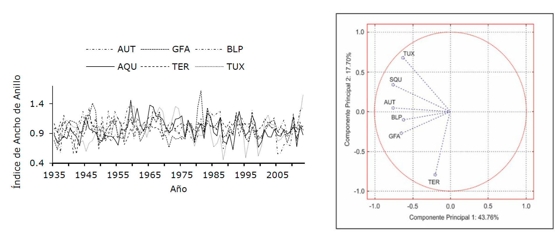
Índice de Ancho de Anillo = Ring Width Index; Año = Year; Componente Principal = Principal Component.
Figure 2 Interannual behavior of the growth indices of the total ring series for the common period (1935-2013) (left) and behavior of the series when analyzed using Principal Components (right).
The integration of the original measurement bases of these sites, excluding the chronology of the TER site, resulted in a time series of 215 years (1800-2014), in which the period with a significant Expressed Population Signal (EPS ≥ 0.85) was from 1860 to 2014 (155 years) with more than seven radii, so for runoff reconstruction purposes it was the period considered in the analysis (Figure 3).
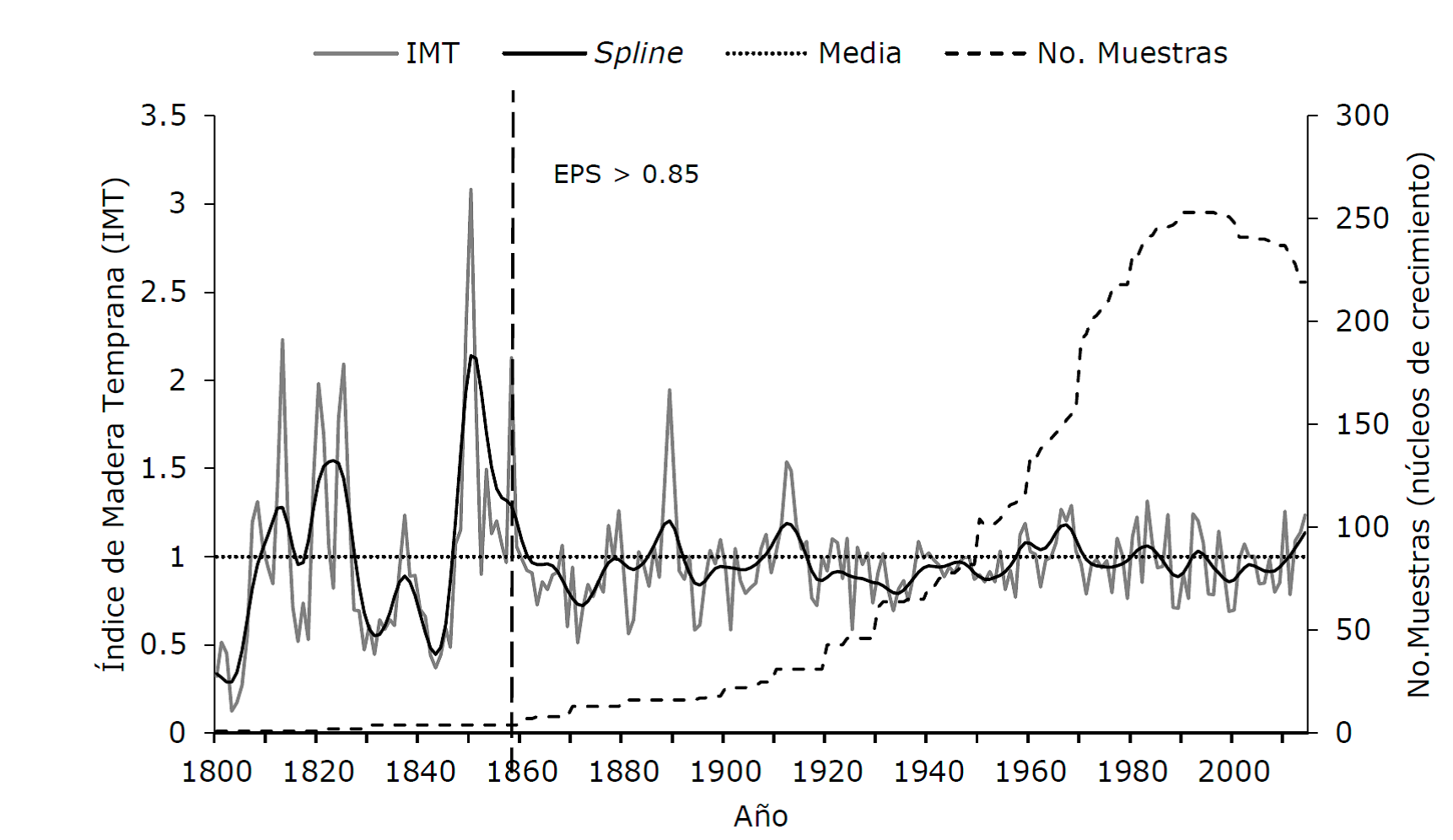
Índice de Madera Temprana = Early Wood Index; No. Muestras (núcleos de crecimiento) = No. Samples (growth nuclei); Media = Mean.
Figure 3 Regional early wood chronology, representative of the Coahuayana hydrological subregion.
The best response between the regional series of earlywood, latewood, and total ring width and the hydrometric data was between the early wood chronology and the gauged records of the Quito hydrometric station (r = 0.62, p <0.01, n = 54); Therefore, the dendrohydrological analysis was limited to this basin, whose hydrometric station registers 90 % of the annual runoff produced in the Coahuayana hydrological subregion of the state of Jalisco.
A more detailed analysis between the early wood series and the records from the Quito hydrometric station in the previous months from June to December and during the growing year (January-December), indicated that the monthly volumes from January to June had a significant association (p <0.05) with the early wood indices both, monthly and seasonally (Figure 4).
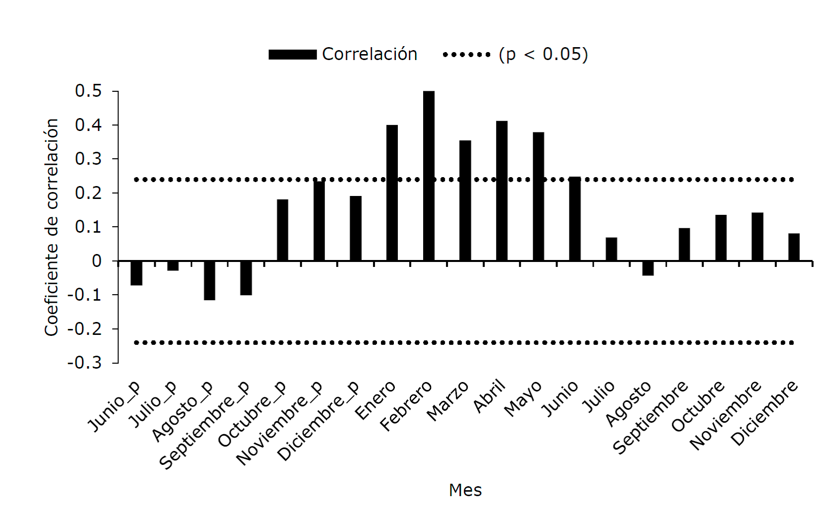
Coeficiente de correlación = Correlation coefficient; Mes = Month; Junio = June; Julio = July; Agosto = August; Septiembre = September; Octubre = October; Novembre = November; Diciembre = December; Enero = January; Febrero = February; Marzo = March; Abril = April; Mayo = May.
Values above or below the dotted lines are significant (p <0.05).
Figure 4 Correlations between regional early wood chronology and monthly hydrometric records from the Quito hydrometric station.
When considering the accumulated January-June flow of the 1952-2005 period, the association increased to 0.62 (p <0.01) and when normalizing the accumulated flow with log10, the correlation reached 0.70 (p <0.01).
The results of the model calibration process were significant (p <0.01), both in the total period of records (1946-2005, r = 0.70, p <0.01, n = 54) that explains 50 % of the variation in runoff, as in the sub-periods 1946-1974 (r = 0.64, p <0.01) and 1975-2005 (r = 0.74, p <0.01). The verification process in both subperiods was significant for various statistical tests such as correlation, sign test, “t” test and first significant difference. The subperiod from 1975 to 2005 was used to generate the reconstruction model, which was the following:
Where:
Y i = Seasonal January-June volume reconstructed in log10
X i = Index of regional early wood chronology standard version
The annual values in log10 were transformed to metric units to obtain volumes in thousands of m3 (Figure 5).
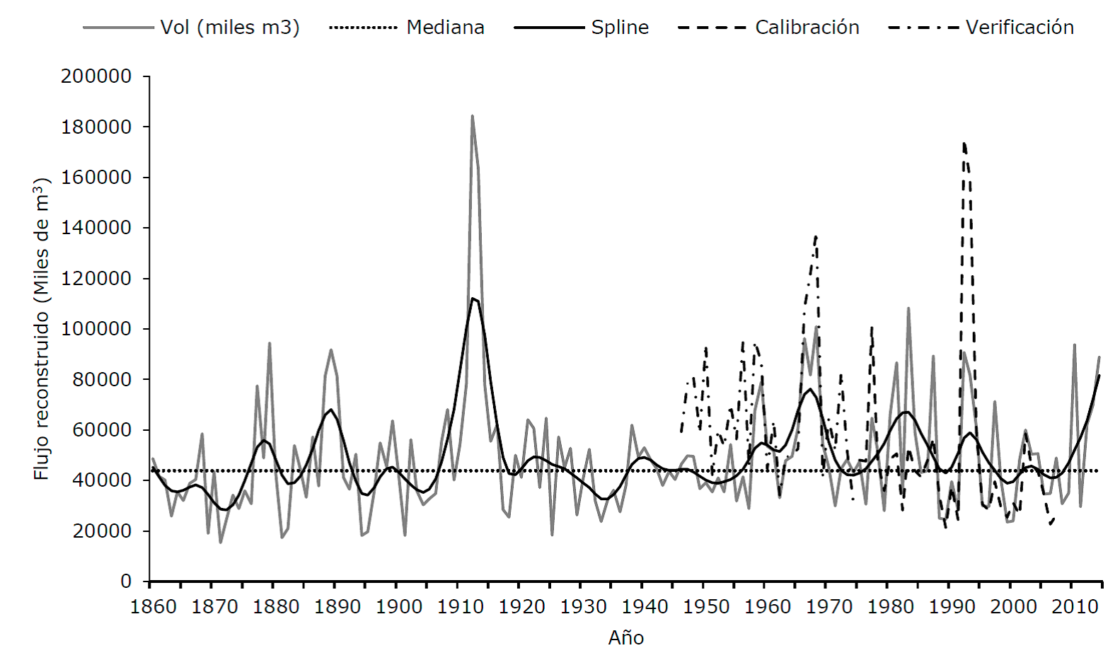
Flujo reconstruido (Miles de m 3 ) = Reconstructed flow; Año =Year.
The dashed lines represent the hydrometric records used for the calibration test (1975-2005) and verification (1946-1974) of the reconstruction model.
Figure 5 Reconstructed seasonal volume January-June for the Quito basin in the Coahuayana hydrological subregion, Jalisco state.
Based on the reconstructed median and considering as wet events the median ± 0.5 of the standard deviation (24039.4) for wet and dry events, respectively; the dominance of humid periods is observed. The longest droughts correspond to the periods 1861-1867, 1869-1876, 1903-1906, 1932-1937, 1949-1953 and 1988-1991, where the most severe drought occurred from 1869 to 1876; while some of the wettest events took place in the periods 1888-1890, 1910-1916, 1980-1981, 1983-1984, 1992-1994 and 2012-2014.
The greatest influence of atmospheric phenomena in the regional growth series on the variability of the climate of this region is attributed to the ENSO phenomenon during the winter-spring and early summer period, when the regional early wood chronology registered a correlation of -0.47 (p <0.01, 1952-2014) and 0.43 (p <0.01, 1953-2014) with the SOI and with the MEI in the January-June and November-July periods, respectively; A significant association was also observed with PDO in the seasonal July-February period (0.38, p <0.01, 1949-2011), but the correlation with AMO indices was not significant (p> 0.05) (Figure 6).
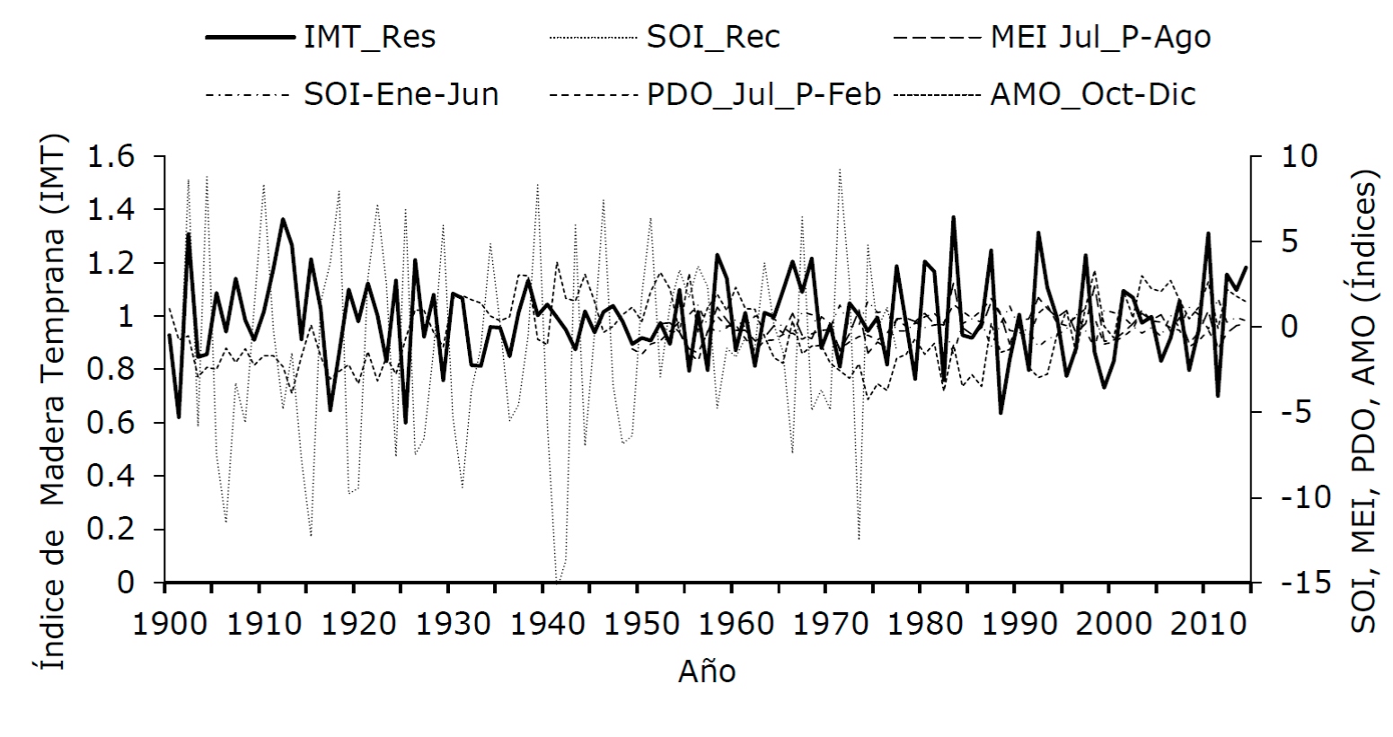
Índice de Madera Temprana = Early Wood Index; Año = Year.
Figure 6 Behavior of the circulatory phenomena indices (ENSO, AMO, PDO) in regard to the early wood index (dark solid line), representative of the Quito hydrological basin, Coahuayana hydrological subregion.
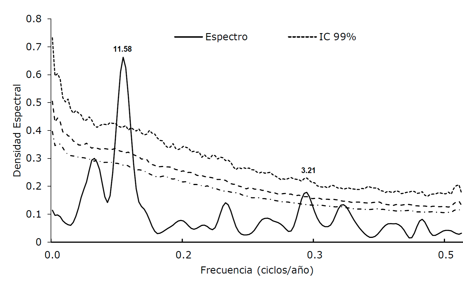
The power spectral analysis in the early wood regional growth series showed the presence of significant periodicities every 11.58 and 3.21 years (Figure 7).
Discussion
The individual chronologies of the total ring width were satisfactorily dated according to the intercorrelation between series (0.42 to 0.544), which exceeded the reference value (0.328, p <0.01); while the medium sensitivity (0.219 to 0.401) is considered adequate for hydroclimatic reconstruction purposes (Speer, 2010). Values similar to those of this study have been reported with Abies guatemalensies Rehder, Abies Religiosa (Kunth) Schltdl. et Cham. and Pinus strobiformis Engelm. in Michoacán and Oaxaca (Carlón-Allende et al., 2018; Aquino et al., 2019).
Although the dendrochronological series were made up of various coniferous species, the association between chronologies was significant, with correlation values between 0.35 and 0.67, which implies the influence of climatic variables of regional impact and a similar response of the coniferous species in this region. The foregoing was corroborated with the Principal Component Analysis that integrated all the chronologies in the first component, except for the Terrero site, which despite correct dating, its interannual variability shows a different climatic signal, probably influenced by changes in the use of the soil (INEGI, 2000).
The integration of a network of dendrochronological series made up of various species has made it possible to analyze in various geographic regions of the continent, the reconstruction of drought indices (Cook et al., 2010; Stahle et al., 2016), ENSO indices (Stahle et al., 1998) and flows in wide regions of North America (Woodhouse et al., 2006; Anderson et al., 2019) and Mexico (Villanueva et al., 2017; Martínez-Sifuentes et al., 2020).
The regional chronology of early wood registered a significant association with the accumulated volumes of the January-June period; this means that the precipitation that occurs in the winter, spring and early summer seasons, on which the drained volumes depend, defines the growth of early wood in western Mexico. Some studies have pointed out the effect of winter-spring precipitation conditions in explaining the growth of early wood and the total ring width in some conifer species from temperate forests of Mexico, such as Pinus douglasiana, Abies religiosa and Pinus pseudotrobus of Mexico (Cerano et al., 2013; Carlón et al., 2016).
The reconstruction of January-June runoff in the Quito basin, characterized by the dominance of wet periods derived from the presence of large-scale climatic phenomena (Stahle et al., 2020), also suggests the presence of prolonged droughts in the XIXth and XX th centuries; thus, the drought from 1869 to 1876 affected the recovery of Chapala Lake (Villanueva et al., 2012) and in 1866 and 1876, there was little clastic contribution (indicative of drought); as supported by a sediment study carried out in a lake in western Jalisco (Sosa-Nájera et al., 2010); the same thing was also detected in winter-spring precipitation reconstructions (January-May) for the Sierra de Manantlán and Bosque La Primavera, Guadalajara, Jalisco (Cerano et al., 2013; Villanueva et al., 2018). The droughts in this region of the country resulted in food shortages for the population of Jalisco and Michoacán (Escobar, 1997).
In the XXth century, the droughts from 1932 to 1937, 1949 to 1953 and 1988 to 1991 have been well documented in climatic, hydrological and dendroclimatic reconstruction records, both for their impact on food production and for their social and economic effect (Domínguez, 2016). The 1949-1953 drought was the most severe of the XXth century in northern Mexico and southwestern United States of America (Seager et al., 2009), which is reflected in reduced runoff in the Conchos basin (Martínez-Sifuentes et al., 2020) and its effect is also corroborated in southern Jalisco.
The drought from 1869 to 1876, present in other precipitation reconstructions (Cerano et al., 2013), has no precedent in the hydrological records of the Quito hydrometric station, and although the water availability in this basin does not seem to be limiting for productive purposes, a low availability of water can affect ecological processes of the forest and riparian ecosystems of this region, as well as for irrigation purposes; therefore, it is important to consider these events and design water management plans to mitigate their effects. Among them we can mention the modernization of irrigation in irrigated areas, use of species with less water requirement, sustainable management of the forest that favors hydrological stability, among other conservation actions.
The wet periods detected in the reconstruction are similar to those registered for the Sierra de Manantlán (Cerano et al., 2013) and implied greater runoff entries to Chapala Lake, such as the periods 1877-1879, 1938-1942, 1963- 1970 and 1992-1994 (Villanueva et al., 2012).
Phenomena of general circulation that show an impact on the climate of Mexico are ENSO, AMO and PDO, but the degree of influence is different in each of the regions of the country (Stahle et al., 2011). ENSO, through its tele-connections, is the phenomenon that most impacts the climate of Mexico (Magaña et al., 1999; Stahle et al., 2016). In the northern region of the country, the warm phase of this phenomenon (Niño) increases precipitation in the cold season of the year, but inhibits it during the cold phase (Niña), which produces drought conditions and its effect is opposite in the central and southern Mexico (Méndez and Magaña, 2010).
In this study, the early wood series showed a correlation of -0.47 (p <0.01) with the January-June SOI and 0.43 with MEI, which corroborates that ENSO exerts a positive influence on precipitation and, therefore, favors the winter-spring runoff in the Coahuayana hydrological subregion of the state of Jalisco. The influence of ENSO in this region defined significant peaks of 2.21 and 11.58 years, in which the 2.21 years is included in the dominant frequencies of ENSO (Bruun et al., 2017), while the 11.58 years may be associated with dominant frequencies of the PDO (Mantua and Hare, 2002).
In regard to the PDO, the positive association between the previous July to February of the current growth years assumes that this phenomenon affects runoff in the study region, although its effect is more noticeable in northern Mexico in the winter and in the summer (Méndez et al., 2010), when it behaves in phase with ENSO (Méndez and Magaña, 2010). The influence of AMO was not significant as described for other regions of Mexico (Stahle et al. 2020). The positive influence of ENSO and PDO has not been studied for this region of the country and the physical process that may originate this behavior is unknown; ENSO-AMO interaction studies have been referred to the Yucatán peninsula, where droughts coincide with the cold AMO phase in periodicities of 10 years (Mendoza et al., 2007).
Conclusions
The development of a dendrochronological network and integrated into a representative chronology of the Armería-Coahuayana hydrological subregion, made up of several conifer species, showed a common climatic response, which provides an option to extend the understanding of interannual hydroclimatic variability over time and over the years.
Of the dendrochronological series of early, late and total ring width, early wood responds with the greatest significance to the runoff accumulated in the winter-spring and early summer seasonal period, which implies that the precipitation of this period and its direct relationship with runoff has the greatest influence upon the annual increment of early wood from conifers in this hydrological subregion.
Of the ENSO, PDO, AMO ocean-atmosphere phenomena), ENSO is the one that best explains the interannual and multiannual hydrological variability of the Coahuayana hydrological subregion.
Acknowledgements
This study received funding from the projects Conacyt CB-2016-01-283134, "Mexican dendrochronological network: hydroclimatic and ecological applications"
REFERENCES
Anderson, S. R., R. Ogle, G. Tootle and A. Oubeidillah. 2019. Tree-ring reconstructions of streamflow for the Tennessee Valley. Hydrology 6: 34. Doi:10.3390/hydrology6020034. [ Links ]
Aquino R., M., A. Velázquez M., J. Villanueva D., H. L. Hervert Z., A. Gómez G., V.,J. Reyes H. y G. Ramírez V. 2019. Respuesta climática de Abies guatemalensis Rehder en Ixtlán de Juárez, Oaxaca, México. Madera y Bosques 25 (2): e2521773. Doi:10.21829/myb.2019.2521773. [ Links ]
Bruun, J. T., J. I. Allen and T. J. Smyth. 2017. Heartbeat of the Southern Oscillation explains ENSO climatic resonances. Journal of Geophysical Research Oceans 122: 6746-6772. Doi:10.1002/2017JC012892. [ Links ]
Bunn, A., M. Korpela, F. Biondi, F. Campelo, P. Merian, F. Qeadan, C. Zang C., D. Pucha C. and J. Wernick. 2018. dplR: Dendrochronology Program Library in R. R package version 1.6.7. https://r-forge.r-project.org/projects/dplr/ (10 de septiembre de 2020). [ Links ]
Carlón A., T., M. E. Mendoza, D. R. Pérez-Salicrup, J. Villanueva-Díaz and A. Lara. 2016. Climatic responses of Pinus pseudostrobus and Abies religiosa in the Monarch Butterfly Biospheres Reserve, central Mexico. Dendrochronologia (38): 103-116. Doi: 10.1016/dendro.2016.04.002. [ Links ]
Carlón-Allende, T., J. Villanueva-Díaz, M. E. Mendoza and D. R. Pérez-Salicrup. 2018. Climate signal in earlywood and latewood in conifer forests in the Monarch Butterfly Biosphere Reserve, Mexico. Tree-Ring Research 74(1); 63-75. Doi: 10.3959/1536-1098-74.1.63. [ Links ]
Cerano P., J., J. Méndez G., A. Amaro S, J. Villanueva D., R. Cervantes M. y E. Rubio C. 2013. Reconstrucción de precipitación invierno-primavera con anillos anuales de Pinus douglasiana en la Reserva de la Biósfera de Manantlán, Jalisco. Revista Chapingo Serie Ciencias Forestales y del Ambiente. Doi:10.45154/rrchscfa.2013.02.007, Pp. 413-423. [ Links ]
Comisión Nacional del Agua (Conagua). 2018. Estadísticas del agua en México, edición 2018. Secretaría del Medio Ambiente y Recursos Naturales. Ciudad de México, México. 303 p. [ Links ]
Cook, E. R. and K. Peters. 1981. The smoothing spline a new approach to standardizing forest interior tree-ring width series for dendroclimatic studies. Tree-Ring Bulletin (41): 45-53. http://hdl.handle.net/10150/261038 (14 de septiembre de 2020). [ Links ]
Cook, E. R. 1987. The decomposition of tree-ring series for environmental studies. Tree-Ring Bulletin (47): 37-59. http://hdl.handle.net/10150/261788 . (14 de septiembre de 2020). [ Links ]
Cook, E. R. , R. Seager, R. R. Heim Jr., R. S. Vose, C. Herweijer and C. Woodhouse. 2010. Megadroughts in North America: placing IPCC projections of hydroclimatic change in a long-term palaeoclimate context. Journal of Quaternary Science (25): 48-61. Doi: 10.1002/jps.1303. [ Links ]
Domínguez, J. 2016. Revisión histórica de las sequías en México: de la explicación divina a la incorporación de la ciencia. Tecnología y Ciencias del Agua 7(5): 77-93. http://revistatyca.org.mx/ojs/index.php/tyca/article/view/1272 (7 octubre 2020) [ Links ]
Enfield, D. B., A. M. Mestas N. and P. J. Trimble. 2001. The Atlantic multidecadal oscillation and its relation to rainfall and riverflows in the continental U.S. Geophysical Research letters 28(10): 2077-2080. Doi:10.1029/2000GL012745. [ Links ]
Escobar O., A. 1997. Las sequías y sus impactos en la sociedad del México decimónico. In: García A., V. (ed.). Historia y Desastres en América latina, Vol. II. Red de Estudios Sociales en Prevención de Desastres en América Latina pp. 170-202. http://www.desenredando.org . (1 de octubre de 2020). [ Links ]
Holmes, R. L. 1983. Computer-assisted quality control in tree-ring dating and measurement. Tree-Ring Bulletin (43): 69 -78. https://repository.arizona.edu/handle/10150/261223 . (5 de septiembre de 2020). [ Links ]
García de Miranda, E. 1989. IV.4.10 Climas, Atlas Nacional de México. Escala 1: 4 000 000. Instituto de Geografía, UNAM. México, D. F., México. 90 p. [ Links ]
Instituto Nacional de Estadística Geografía e Informática (INEGI). 1995. Estudio hidrológico del Estado de Colima. Instituto Nacional de Estadística Geografía e Informática. Aguascalientes, Ags., México. 28 p. [ Links ]
Instituto Nacional de Estadística Geografía e Informática (INEGI). 2000. Estudio hidrológico del Estado de Jalisco. Instituto Nacional de Estadística Geografía e Informática. Aguascalientes, Ags., México. 176 p. [ Links ]
Magaña, V., J. L. Pérez, J. L. Vázquez, E. Carrisoza y J. Pérez. 1999. El Niño y el clima. In: Magaña Ríos, V.O. (Ed.). Los impactos de El Niño en México. SEP-Conacyt. México, D. F. México. 229 p. [ Links ]
Mantua, N., S. Hare, Y. Zhang, J. Wallace and R. Francis. 1997. A Pacific interdecadal climate oscillation with impacts on salmon production. Bulletin of the American Meteorological Society. (78): 1069-1079. Doi:10.1175/1520-0477(1997)078<1069:APICOW>2.0.CO;2. [ Links ]
Mantua, J. N. and S. R. Hare. 2002. The Pacific Decadal Oscillation. Journal of Oceanography 58: 35-44. Doi: 10.1023/A:1015820616384. [ Links ]
Martínez-Sifuentes, A. R., J. Villanueva-Díaz, T. Carlón-Allende and J. Estrada-Ávalos. 2020. 243 years of reconstructed streamflow volume and identification of extreme hydroclimatic events in the Conchos River Basin, Chihuahua, Mexico. Trees 34:1347-1361. Doi:10.1007/s00468-020-02002-w. [ Links ]
Méndez, M. and V. Magaña. 2010. Regional aspects of meteorological droughts over Mexico and Central America. Journal of Climate 23(5): 1175-1188. Doi:10.1175/2009JCLI3080.1. [ Links ]
Méndez G., J., A. Ramírez L., E. Cornejo O., A. Zárate L. y T. Cavazos P. 2010. Teleconexiones de la Oscilación Decadal del Pacífico (PDO) a la precipitación y temperatura en México. Investigaciones Geográficas, Boletín del Instituto de Geografía (73): 57-70. http://www.scielo.org.mx/scielo.php?script=sci_arttext&pid=S0188-46112010000300005&lng=es&nrm=iso (7 de octubre de 2020). [ Links ]
Mendoza, B., V. García A., V. Velasco, E. Jáuregui and R. Diaz S. 2007. Frequency and duration of historical droughts from the 16th to the 19th centuries in the Mexican Maya lands, Yucatan Peninsula. Climate Change (83):151-168. Doi: 10.1007/s10584-006-9232-1. [ Links ]
Ortega-Gaucín, D. 2018. Medidas para afrontar la sequía en México: una visión retrospectiva. Revista de El Colegio de San Luis 8(15): 77-105. Doi: 10.21696/rcsl8152018743 [ Links ]
Riva A., I. 2015. Efectos del cambio climático en los recursos hídricos de México. In: Arreguín C., F. I, M. López P., O. Rodríguez L. y M. J. Montero M. (coords.). Atlas de vulnerabilidad hídrica en México ante el cambio climático. Instituto Mexicano de Tecnología del Agua. Jiutepec, Mor., México. pp. 89-98. [ Links ]
Robinson, W. J. and R. Evans. 1980. A microcomputed-based tree-ring measuring system. Tree-Ring Bulletin 40: 59-64. http://hdl.handle.net/10150/2604043 (21 de septiembre de 2020). [ Links ]
Schweingruber, F. H. 1996. Tree rings and environment. Dendroecology. Birmendsdorf, Swis Federal Institute for Forest, Snow and Landscape Research. Berne, Stugart, Vienna, Haupt, Switzerland. 609 p. [ Links ]
Seager, R., M. Ting, M. Davis, M. Cane, N. Naik, J. Nakamura, C. Li, E. Cook. and D. W. Stahle. 2009. Mexican drought: an observational modeling and tree ring study of variability and climate change. Atmósfera 22(1): 1-31. https://www.redalyc.org/articulo.oa?id=56512093001 (3 de septiembre de 2020). [ Links ]
Speer, J. 2010. Fundamentals of tree-ring research. University of Arizona Press. Tucson, AZ, USA. 509 p. [ Links ]
Sosa-Nájera, S., S. Lozano-García, P. D. Roy y M. Caballero. 2010. Registro de sequías históricas en el occidente de México con base en el análisis elemental de sedimentos lacustres: El caso del lago de Santa María del Oro. Boletín de la Sociedad Geológica Mexicana 62(3): 437-451. https://www.redalyc.org/articulo.oa?id=94319371009 (9 de septiembre de 2020). [ Links ]
Stahle, D. W., R. D. D’Arrigo, P. J. Krusic, M. K. Cleaveland, E. R. Cook, R. J. Allan, J. E. Cole, R. B. Dunbar, M. D. Therrell, D. A. Guy, M. D. Moore, M. A. Stokes, B. T. Burns, J. Villanueva D. and L. G. Thompson. 1998. Experimental dendroclimatic reconstruction of the Southern Oscillation. Bulletin of the American Meteorological Society 70(10): 2137-2152. Doi: 10.1175/1520-0477(1998)079>2137EDROTS>2.0CO:2. [ Links ]
Stahle, D. W. , D. J. Burnette, J. Villanueva D., R. R. Heim Jr., F. K. Fye, J. Cerano P., R. Acuña S. and M. K. Cleaveland. 2011. Pacific and Atlantic influences in Mesoamerican over the past millennium. Climate Dynamics 39:1431-1446. Doi: 10.1007/s00382-011-1205-z. [ Links ]
Stahle, D. W. , E. R. Cook, D. J. Burnette, J. Villanueva, J. Cerano, J. N. Burns, D. Griffin, B. I. Cook, R. Acuña, M. C. A. Torbenson, P. Szejner and I. M. Howard. 2016. The Mexican Drought Atlas: tree-ring reconstructions of the soil moisture balance during the late pre-Hispanic, colonial, and modern eras. Quaternary Science Reviews 149: 34-60. Doi: 10-1016/j.quascirev.2016.06.018. [ Links ]
Stahle, D. W., E. R. Cook, D. J. Burnette, M. C. A. Torbenson, I. M. Howard, D. Griffin, J. Villanueva D., B. I. Cook, A. P. Willimas, E. Watson, D. J. Sauchyn, N. Pesderson, C. A. Woodhouse, G. T. Pedderson, D. Meko, B. Coulthard and C. J. Crawford. 2020. Dynamics, variability, and change in seasonal precipitation reconstructions for North America. Journal of Climate 33: 3173-3194. Doi: 10.1175/JCLI-D-19-0270.1. [ Links ]
Stokes, M. A. and T. L Smiley. 1968. An introduction to Tree-Ring Dating, University of Arizona Press. Tucson, AZ, USA. 73 p. [ Links ]
Villanueva D., J., J. Cerano P., J. de Dios Benavides S., D. W. Stahle, J. Estrada Á., V. Constante G. y M. Tostado P. 2012. Reconstrucción de los niveles del Lago de Chapala con series dendrocronológicas de Taxodium mucronatum Ten. Revista Mexicana de Ciencias Forestales 3(14):55-68. Doi: 10.29298/rmcf.v3i14.474. [ Links ]
Villanueva, J., A. Gómez, J. Cerano, S. Rosales. J. Estrada, L. U. Castruita y A. R. Martínez. 2017. La variabilidad del caudal del río Acaponeta inferida mediante series de anillos de crecimiento en coníferas. Tecnología y Ciencias del Agua 8(3): 55-74. [ Links ]
Villanueva D., J. , E. A. Rubio C., A. A. Chávez D., J. L. Zavala A., J. Cerano P. y A. R. Martínez S. 2018. Respuesta climática de Pinus oocarpa Schiede ex Scheletol en el Bosque La Primavera, Jalisco. Madera y Bosques 24(1):1-32. Doi:10.21829/myb.2018.2411464. [ Links ]
Wigley, M. L., K. R. Brifa and P. D. Jones. 1984. On the average value of correlated time series, with applications in dendroclimatology and hydrometeorology. American Meteorological Society (23): 201-213. Doi: 10.1175/1520-0450(1984)023>0201:OTAVOC>2.0.CO2. [ Links ]
Wilks, D. S. 1995. Statistical methods in the atmospheric sciences: an introduction. Academic Press. New York, NY, USA. 463 p. [ Links ]
Wolter, K. and M. S. Timlin. 2011. El Niño/Southern Oscillation behavior since 1871 as diagnosed in an extended multivariate ENSO index (MEI.ext). International Journal of Climatology (31): 14. Doi:10.1002/joc.2336. [ Links ]
Woodhouse, C. A., S. T. Gray and D. M. Meko. 2006. Updated streamflow reconstructions for the Upper Colorado River Basin. Water Resources Research 42: W05415. Doi:10.1029/2005WR004455. [ Links ]
Received: September 25, 2020; Accepted: January 29, 2021
 Este es un artículo publicado en acceso abierto bajo una licencia Creative Commons
