


Servicios Personalizados
Revista
Articulo
 texto en
  Inglés (pdf)
 Artículo en XML
 Referencias del artículo
 Enviar artículo por email
Indicadores
-
 Citado por SciELO
 -
 Accesos
Links relacionados
-
 Similares en
SciELO
Similares en
SciELO
Compartir

 Permalink
Revista mexicana de ciencias forestales
versión impresa ISSN 2007-1132
Rev. mex. de cienc. forestales vol.11 no.61 México sep./oct. 2020 Epub 20-Ene-2021
https://doi.org/10.29298/rmcf.v11i61.794
Scientific article
Drones: technology with a promising future in forest management
1Facultad de Ciencias Forestales, Universidad Juárez del Estado de Durango. México.
2Facultad de Ingeniería, Universidad Autónoma de San Luis Potosí. México.
3Instituto de Silvicultura e Industria de la Madera, Universidad Juárez del Estado de Durango. México.
Climate variability points out important challenges that forest ecosystems are currently facing. In order to better understanding their vital processes, it is necessary to have cutting-edge technologies and unmanned aerial vehicles (UAV) play a fundamental role. Its applications have been extended to civilian use, natural disaster response, humanitarian action, and earth science research. Although UAV have been used for different tasks and services, there is a lack of information on the state of the art of methods, uses and trends in forest management. This paper contributes to knowledge in terms of research volume over time, differentiated by journals and countries; most influential papers and authors; scientific collaboration networks; types of vegetation and fields of study; hardware and software that are relevant for forest monitoring. The results showed 117 scientific papers published from 2012 to 2019, mainly in China and USA including five clusters of scientific collaborations. The studies focused on individual attributes of forest structure, inventories, and vigor forest monitoring. Also, temperate forests were mostly studied around the world. The rotorcrafts drones were the most used with RGB sensor from DJI as the dominant market leader. Photoscan was the photogrammetry software more applied on forestry research. Lastly, we confirm that UAV are exponentially expanding over the last five years. In Mexico, this potential is expected to increase, taking advantage of its mega diversity, great forestry tradition and the researchers that are becoming specialized.
Key words: Bibliographic database; bibliometrics; forestry studies; forest resources; photogrammetry software; unmanned aerial vehicles
La variabilidad climática plantea importantes retos que actualmente enfrentan los ecosistemas forestales. Para mejorar el entendimiento de sus procesos vitales es necesario contar con tecnologías de vanguardia, una de los cuales son los vehículos aéreos no tripulados (VANT) que desempeñan un papel fundamental. Si bien, los VANT se han usado para diferentes tareas y servicios; existe un vacío de información sobre el estado del arte de los enfoques, usos y tendencias en la gestión forestal. Este estudio es una aportación al conocimiento, en términos de volumen de investigación a través del tiempo; diferenciada por revistas y por países; artículos y autores más influyentes; redes de colaboración científica; tipos de vegetación y campos de estudio; hardware y software relevante utilizado. Los resultados mostraron 117 artículos científicos publicados del 2012 al 2019, principalmente de China y Estados Unidos de América, y cinco clústeres de colaboración científica. Los estudios se enfocaron, principalmente, en los atributos individuales de la estructura forestal, inventarios y monitoreo del vigor forestal. Los bosques templados fueron los ecosistemas más estudiados alrededor del mundo, mientras que los drones de multirrotor los más usados con el sensor RGB de DJI como la marca líder dominante. El Photoscan fue el programa fotogramétrico más aplicado en investigación forestal. Por último, se confirma que el uso de los VANT se ha expandido exponencialmente en el último lustro. En México, se prevé que dicho potencial se incremente, a partir de su megadiversidad, gran tradición forestal y los investigadores que están especializándose en el tema.
Palabras clave: Base de datos bibliográfica; bibliometría; estudios forestales; recursos forestales; software fotogramétrico; vehículos aéreos no tripulados
Introduction
The effects of climate variability in forest ecosystems and the plasticity capacities of vegetation confer the need to monitor the ecological processes that occur there. For example, climate change through extreme and continuous variations has impacted on the biogeography of vegetation (Ackerly et al., 2010), phenological variations (Piao et al., 2019), signs of decay (Gustafson and Sturtevant, 2013) and changes in productivity rates (García-Valdés et al., 2020). These consequences of vulnerability highlight the need to generate higher quality information and knowledge that improve the understanding of the ecological mechanisms faced by plants.
In recent years, the scientific community has undertaken various efforts focused on contributing to the development of forest science in this field. A notable example is the application of remote sensors linked to dendroecological variables to explain changes in forest growth (Babst et al., 2018; Vicente-Serrano et al., 2016). Thus, in the search to refine knowledge at spatial scales of greater resolution and precision, the scientific literature records a vertiginous development in technologies such as UAVs (Unmanned Aerial Vehicles), UAVs (Unmanned Aerial Vehicle, for its acronym in English), RPAS (Remotely Piloted Aircraft System, for its acronym in English), or commonly called drones (ICAO, 2011). Colomina and Molina (2014) define them as complete systems that integrate: the unmanned aerial vehicle, the ground control station and the communication data link. In addition to this, for photogrammetry and remote sensing applications, these platforms must be accompanied by visible band, near infrared, multispectral, hyperspectral, thermal, laser or synthetic aperture radar cameras.
However, despite its increasing use (Salamí et al., 2014; Yao et al., 2019), there are still gaps in information on the situation, trends and areas of opportunity for application in forest studies. Furthermore, the flexibility, dynamism and diversity of these geospatial technologies make their continuous study imperative (Beloev, 2016). Consequently, documenting and systematizing the state of the art on the main approaches, uses and trends of UAV in forest scientific studies would contribute to enhance the scope of some lines of specialized research using this platform (Gambella et al., 2016).
Therefore, the objective of this study was to carry out an analysis of the perspective offered by drones applied in forestry studies around the world, through an exhaustive review of literature, to generate a situational diagnosis and areas of opportunity, as a tool that help select better parameters to explain the ecological processes underlying the dynamics of ecosystems.
Search methods and criteria
This study focused on the review of scientific articles that address the use of UAV with passive sensors (RGB, thermal, multispectral and hyperspectral cameras) in forestry studies. A search was carried out in the Scopus scientific repository (https://www.scopus.com), this due to the fact that various authors describe advantages (greater number of journals, documents and citations) over other scientific databases (Granda-Orive et al., 2013; AlRyalat et al., 2019). The search process covered the period from 2012 to 2019 with the keywords "UAV", "forest" and "forestry".
Studies classified as the so-called “gray literature” (theses, conference proceedings, technical brochures, etc.) were excluded, since these are not subject to strict arbitration reviews or do not comply with bibliographic control norms and impact indexes.
With the database downloaded from Scopus, an analysis of co-authorship and scientific collaboration networks was carried out using the VOSviewer software, considering at least two contributions per author (Van and Waltman, 2019). This analysis has shown its high efficiency in similar studies (Martínez-Santiago et al., 2017).
Subsequently, the information from the reviewed scientific articles was captured and systematized in a spreadsheet with the following fields: reference, year of publication, article title, journal, impact factor, number of citations, annual rate of citations, number of authors, number of institutions involved, country of the corresponding author, study objective, field of knowledge, size of the study area, vegetation and land use, climate, UAV type, model, sensor type, spatial resolution, height flight and photogrammetric software used.
The data were grouped and classified in order to facilitate the elaboration of comparative tables and graphs to fulfill the purpose of the present study.
Articles published over time and magazines with more publications
The search yielded 229 articles in total, which were filtered to select 177 studies related to the main objective of this research (see supplementary material at https://cutt.ly/GrVZRmf). The articles studied were published from 2012 to 2019. It is observed that as of 2015, the average increase in articles published per year was 15.5. The year with the greatest number of publications was 2019, but, the greatest increase compared to the previous year was 2018 (Figure 1).
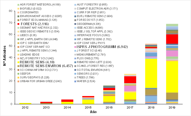
No. de artículos = Number of articles; Año = Year.
Figure 1 Articles published on forest studies that used UAV grouped by year of publication, by journal and impact factor.
This trend could be explained by the growing UAV market in recent years. Market research projected a growth detonation from 2013; USD $ 19.3 trillion was estimated in 2019 and USD 45.8 trillion is forecast for 2025 (Markets and Markets, 2019).
In addition to the above, Colomina and Molina (2014) reported that UAV development tripled from 2005 to 2014. In addition, a relevant increase was observed in the type of civil / commercial platforms, especially in 2012 and 2013, a category to which they belong to UAVs used in forestry studies with sensors that provide high resolution images.
On the other hand, the 177 studies analyzed were distributed in 45 scientific journals. Remote Sensing and Forest stand out with 70 and 21 articles published respectively, which together represent 51 % of all the articles analyzed. The journals with the highest impact factor are Remote Sensing of Environment and ISPRS Journal of Photogrammetry and Remote Sensing with 6.457 and 6.942 respectively, which are in the third and fourth place of the journals with the greatest number of publications on the subject (Figure 1).
Remote Sensing leads the number of publications, which is consistent with its editorial focus. It is a specialized magazine that publishes the most avant-garde advances in remote sensing technologies. Its semi-monthly periodicity, its high visibility and rapid publication seem to attract researchers in the field. Similarly, Forest is also one of the most attractive journals for the scientific community in the forestry field, since its efficiency in the editorial process and its impact factor constitute an advantage that scientists seem to take advantage of.
Most cited articles
The annual rate of citations was calculated for each article and they were grouped into six classes. A total of 120 articles presented 0 to 5 citations per year and only 10 articles, more than 20 citations per year (Figure 2 and Table 1).
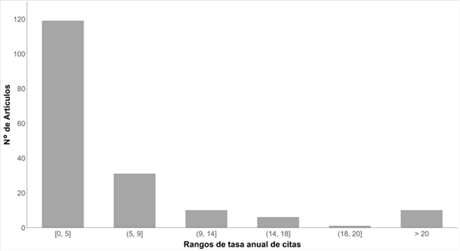
No. de artículos = Number of articles; Rangos de tasa anual de citas = Ranges of annual rate of citations.
Figure 2 Articles published on forest studies that used UAV grouped by ranges of annual rate of citations.
Table 1 Main articles on forest studies that used UAV with the highest annual rate of references in the 2012-2019 period.
| Reference | Title of the article | Journal | CT | CA |
|---|---|---|---|---|
| Nevalainen et al. (2018) | Individual Tree Detection and Classification with UAV-Based Photogrammetric Point Clouds and Hyperspectral Imaging | Remote Sensing | 86 | 43 |
| Wallace et al. (2016) | Assessment of Forest Structure Using Two UAV Techniques: A Comparison of Airborne Laser Scanning and Structure from Motion (SfM) Point Clouds | Forests | 170 | 43 |
| Wallace et al. (2012) | Development of a UAV-LiDAR system with application to forest inventory | Remote Sensing | 272 | 34 |
| Dandois y Ellis (2013) | High spatial resolution three-dimensional mapping of vegetation spectral dynamics using computer vision | Remote Sensing of Environment | 227 | 32 |
| Feng et al. (2015) | UAV Remote Sensing for Urban Vegetation Mapping Using Random Forest and Texture Analysis | Remote Sensing | 130 | 26 |
| Puliti et al. (2015) | Inventory of Small Forest Areas Using an Unmanned Aerial System | Remote Sensing | 123 | 25 |
| Näsi et al. (2015) | Using UAV-Based Photogrammetry and Hyperspectral Imaging for Mapping Bark Beetle Damage at Tree-Level | Remote Sensing | 117 | 23 |
| Cunliffe et al. (2016) | Ultra-fine grain landscape-scale quantification of dryland vegetation structure with drone-acquired structure-from-motion photogrammetry | Remote Sensing of Environment | 92 | 23 |
| Lisein et al. (2013) | A photogrammetric workflow for the creation of a forest canopy height model from small unmanned aerial system imagery | Forests | 153 | 22 |
| Dandois et al. (2015) | Optimal Altitude, Overlap, and Weather Conditions for Computer Vision UAV Estimates of Forest Structure | Remote Sensing | 103 | 21 |
CT = Total quotes; CA = Quotes per year.
The high rate of citations of the articles seems to be related to the growing interest of the scientific community in UAVs. In this way, the most cited articles refer to the most avant-garde procedures and the basic principles of understanding of these technologies; for example, the photogrammetric technique structure from motion (Structure from Motion - SfM) makes it possible to know the descriptive statistics of each pixel and relate it to forest density variables (Wallace et al., 2016; Nevalainen et al., 2018).
Analysis of co-authorship and scientific collaboration networks
The most notable authors in scientific productivity on contributions of UAV use in the forestry sector were: 1) E. Honkavaara, with 10 publications, T. Hakala, with 7 and R. Näsi, with 6. Their productivity rate was associated with the ecosystems of its area of influence and the institutions of its affiliation. Notably, all of them come from world-renowned institutions, located in Finland (e.g. Finnish Geospatial Research Institute, Finnish Geospatial Research Institute and National Land Survey of Finland).
The bibliometric mapping of the scientific collaboration networks confirmed the relative weight of their contributions in the field of study. The co-authorship network was made up of five groups (colors) in which the size of the nodes represents the number of articles and the thickness of the lines, the intensity of the collaboration in terms of the number of manuscripts (Figure 3).
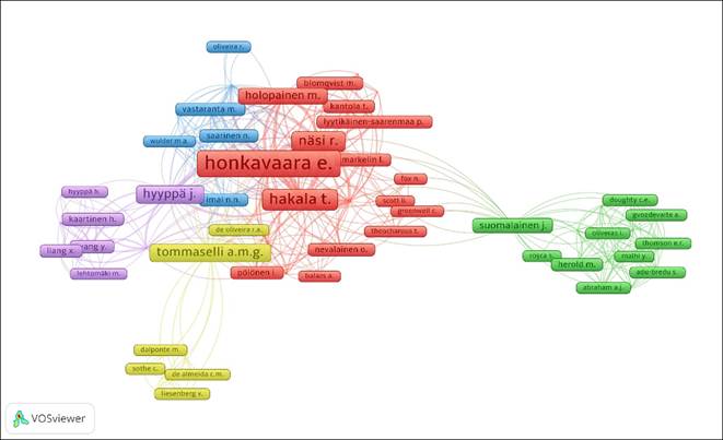
Figure 3 Clusters and scientific collaboration networks in published articles of forestry studies that used UAV.
The authors E. Honkavaara (73 links and 10 articles), T. Hakala (66 links and 7 articles) and J. Näsi (56 links and 6 articles) constitute the researchers with the largest number of scientific collaboration networks, with which confirms its high productivity rate (Figure 3). This representation evidences a nucleus of central authors densely connected with other less important members in terms of shared publications. Their scientific leadership can also be attributed to the research capabilities provided by the institutions in which they participate.
Articles published by country of the corresponding author
Authors from 34 countries participated in the publication of the articles, of which China and the United States have the largest number of publications, 26 and 21 articles, respectively. Finland, Germany, the United Kingdom, and Canada also stand out, which together with China and the United States, represent 57 % of all the articles analyzed in this study (Figure 4).
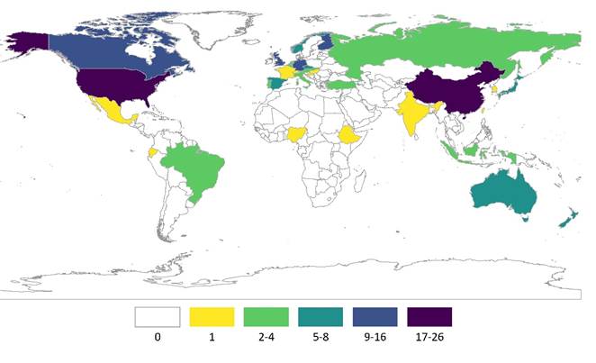
Figure 4 Number of articles published on forest studies that used UAV by country of the corresponding author in the 2012-2020 period.
According to data from the OECD (2019), also the first two countries (China and the United States) make the highest investment in research and development. Germany, the UK and Canada rank 4th, 7th, and 11th respectively. This explains its position at the forefront of new technologies in this area of knowledge. For its part, Finland is characterized as a country with a forest vocation (Kotilainen and Rytteri, 2011), which makes it understandable that it is also listed among the countries with the most articles published in this field that use these new technologies.
Articles published by type of ecosystem and field of application
The type of forest ecosystem most flown over was that of temperate forests with 115 items, representing 65 % of the total number of studies analyzed. Boreal forests were referred to in 14 articles and tropical forests in 13 (Figure 5a).
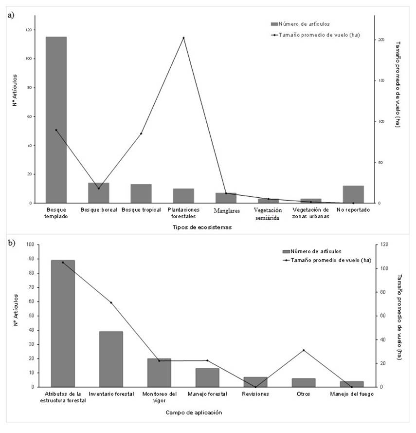
No. de artículos = Number of articles; Tipos de ecosistemas = Ecosystem type; Tamaño promedio de vuelo = Average flight size; Bosque templado = Temperate forest; Bosque boreal = Boreal forest; Bosque tropical = Tropical forest; Plantaciones forestales = Forest plantations; Manglares =Mangrooves; Vegetación semiárida = Semi-arid vegetation; Vegetación de zonas urbanas = Vegetation of urban areas; No reportado = Not reported; Campo de aplicación = Field of application; Atributos de la estructura forestal = Attributes of the forest structure; Inventario forestal = Forest inventory; Monitoreo del vigor = Vigor monitoring; Manejo forestal = Forest management; Revisiones = Reviews; Otros = Other; Manejo del fuego = Fire management.
Figure 5 Number of articles published on forestry studies that used UAV and average flight size (a) by ecosystem type and (b) by field of application.
It is worth mentioning that no studies were found whose objective was to determine the type of forest ecosystem flown over with UAV. Salamí et al. (2014) studied 40 articles dedicated to monitoring areas with vegetation, but they only distinguish agricultural areas and wild areas.
The size of the average flight area in the articles analyzed was 59.2 ha. Forest plantations had the highest average flight cover were with 202.4 ha, while in temperate forests they covered 89.6 ha on average (Figure 5a).
The fact that larger flights are made in forest plantations may be due to the fact that there is interest on the part of technicians and producers to monitor in short periods, at the individual tree level, and parameters of forestry importance, such as: number of trees, cup size, volume estimation and viability analysis (Vásquez-García et al., 2016). In this sense, UAVs provide new possibilities in estimating these parameters, with greater accuracy and less time in obtaining data (Chianucci et al., 2016), which has contributed to the development of a new method to accurately determine forest characteristics and treatments at the level of stands, sub-stands or individual trees: precision forestry (Holopainen et al., 2014).
Temperate forests offer advantages to be flown over and studied by UAV due to low vegetation densities and greater contrasts between seasons throughout the year. Therefore, these ecosystems are considered ideal sites because they facilitate the linking of models and allometric relationships with spectral information derived from the different remote sensors (Kachamba et al., 2017; Ota et al., 2017). This approach is consistent with the results of Figure 4, which illustrates that most of the published studies were in countries with this type of vegetation.
On the other hand, 50 % of the studies analyzed are focused on the attributes of the forest structure, with greater application at the individual tree level (89 articles). The inventories of forest stands and the monitoring of their health involve 39 and 20 items respectively (Figure 5b).
In this context, Iglhaut et al. (2019) report a similar trend in a comparison with 2018, as individual tree inventories and forest health monitoring were the most frequent.
The current interest in conducting exploratory studies on the use of UAVs to calculate structural attributes of forests responds, without a doubt, to the learning curve of new technologies and the need to generate proposals on the usefulness of these devices. In the following years, it is likely that studies on specific applications such as forest management, pest control, post-fire monitoring, among others, will increase.
In Mexico there is high concern about forest fires (Zúñiga-Vásquez et al., 2017), so it is advisable to explore the use of UAVs for prevention, management and monitoring of the effects of different fire regimes (Ghamry et al., 2016; McKenna et al., 2017).
Sensor type, flight height and resolution reached
One of the main advantages of UAVs over satellite images is the spatial resolution or Ground Sample Distance (GSD) (Saadatseresht et al., 2015). The GSD depends on the width of the camera sensor, the focal length and the UAV's flight height (He et al., 2012).
In the present study, the GSD ranged from 0.4 cm to 25 cm for flight heights between 6 m and 325 m. However, most of the flights were made between 75 and 122 m above the ground (Figure 6). The expected relationship between flight height and GSD is not linear because studies that included thermal, multispectral, and hyperspectral cameras were reviewed.

Type of UAV, models and photogrammetric software most used
By wing type, the most widely used UAV was the multirotor, with 117 items. The fixed wing were present in 36 studies and, finally, the single rotor in six (Figure 7a). Tahar and Ahmad (2013) made a comparison between fixed-wing and multirotor UAVs in which they concluded that fixed-wing UAVs allow greater coverage and flight autonomy, but are more expensive than multirotor UAVs; this may explain the predominance of the latter in the articles reviewed.
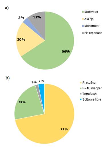
Figure 7 Forest studies that used UAV number of articles by type of wing and (b) percentage of studies by photogrammetric software used.
In terms of manufacturing origin, assembled UAVs were used in 19 of the studies, followed by commercial eBee and Phantom 4 Pro UAVs with 13 and 10 items respectively (Table 2). This may be due to the fact that the brands with the greatest representation in the market offer services and support for the different processes within the workflow (flight planning, execution and information processing). In contrast, assembled UAVs require the development of programs and tools (Shaqura and Shamma, 2017).
Table 2 The 10 most used VANTS in the analyzed forest studies from 2912 to 2019.
| VANT model | Number of Articles |
|---|---|
| Ensambled UAV platform | 19 |
| eBee | 13 |
| DJI Phantom 4 Pro | 10 |
| DJI Phantom 4 | 7 |
| Tarot 960 | 7 |
| DJI Matrice 600 Pro | 6 |
| Mikrokopter | 6 |
| DJI Phantom 3 Pro | 5 |
| DJI Phantom 2 | 4 |
| DJI Phantom 3 | 4 |
Photogrammetry software with UAV PhotoScan widely dominated the researchers' preference, being present in 72 % of cases, followed by Pix4D mapper in 23 %. The group of free and open source software was only verified in 3 % of the studies, a group that includes MicMac, OpenCV libraries, OpenDroneMap and UAV-HiRAP (Figure 7b).
Regarding the quality of the photogrammetric products generated by the software, some studies register that there are no significant differences between the results obtained by PhotoScan and Pix4D mapper ((Georgopoulos et al., 2016; Alidoost and Arefi, 2017; Burns and Delparte, 2017). However, Sona et al. (2014) concluded that Photoscan achieved more reliable results and better products in flat areas and in the presence of shadows than other products.
Researchers are likely to prefer PhotoScan and Pix4D mapper because they offer a more user-friendly interface and workflow. However, there are few options to customize the processing (Niederheiser et al., 2016).
Moutinho (2015) compared proprietary photogrammetric software against free software. Among his findings, it turned out that the second, MicMac, has some superior characteristics (excellent planimetric precision and customization of its own processes), although its main disadvantage was the processing time.
Conclusions
The inherent characteristics of UAVs offer high potential that make them strategic tools with a promising future in forest management. The development of technology in the forestry sector has a long history; however, with the emergence of UAVs, it has undergone rapid development, particularly in the last five years. The creation of collaborative authorship networks, led by Finnish scientists, has been strategic to enhance their development. The dissemination of knowledge is carried out through specialized magazines of rapid diffusion and high impact factor, mainly on issues related to forest structure. Areas of opportunity are looming in applications in management, precision forestry and protection. Due to its biogeography, Mexico is ideal for developing knowledge in this area, although it is urgent to strengthen the training of human resources in these technologies.
Acknowledgements
We are grateful to the National Council for Science and Technology (Conacyt) for the funding granted to the first author to carry out his master's studies, as well as to the MGARFA program of the FCFC; The support of the CONACYT A1-S-21471 project and DendroRed (https://dendrored.ujed.mx) is acknowledged.
REFERENCES
Ackerly, D. D., S. R. Loarie, W. K. Cornwell, S. B. Weiss, H. Hamilton, R. Branciforte and N. J. B. Kraft. 2010. The geography of climate change: implications for conservation biogeography. Diversity and Distributions 16(3): 476-487. Doi:10.1111/j.1472-4642.2010.00654.x. [ Links ]
Alidoost, F. and H. Arefi. 2017. Comparison of UAS-based photogrammetry software for 3D point cloud generation: a survey over a historical site. ISPRS Annals of Photogrammetry, Remote Sensing and Spatial Information Science 4-4/W4: 55-61. Doi:10.5194/isprs-annals-IV-4-W4-55-2017. [ Links ]
AlRyalat, S. A., L. W. Malwaki and S. M. Momani. 2019. Comparing Bibliometric Analysis Using PubMed, Scopus, and Web of Science Databases. Journal of Visualized Experiments 152:e58494. Doi:10.3791/58494. [ Links ]
Babst, F., P. Bodesheim, N. Charney, A. D. Friend, M. P. Girardin, S. Klesse, D. J. P. Moore, K. Seftigen, J. Björklund, O. Bouriaud, A. Dawson, R. J. DeRose, M. C. Dietze, A. H. Eckes, B. Enquist, D. C. Frank, M. D. Mahecha, B. Poulter, S. Record, V. Trouet, R. H. Turton, Z. Zhang and M. E. K. Evans. 2018. When tree rings go global: Challenges and opportunities for retro- and prospective insight. Quaternary Science Reviews 197: 1-20. Doi:10.1016/j.quascirev.2018.07.009. [ Links ]
Beloev, I. H. 2016. A Review on Current and Emerging Application Possibilities for Unmanned Aerial Vehicles. Acta Technologica Agriculturae 19(3): 70-76. Doi: 10.1515/ata-2016-0015. [ Links ]
Burns, J. H. R. and D. Delparte. 2017. Comparison of commercial structure-from-motion photogrammety software used for underwater three-dimensional modeling of coral reef environments. SPRS - International Archives of the Photogrammetry, Remote Sensing and Spatial Information Sciences 42-2/W3: 127-131. Doi:10.5194/isprs-archives-XLII-2-W3-127-2017. [ Links ]
Chianucci, F., L. Disperati, D. Guzzi, D. Bianchini, V. Nardino, C. Lastri, A. Rindinella and P. Corona. 2016. Estimation of canopy attributes in beech forests using true colour digital images from a small fixed-wing UAV. International Journal of Applied Earth Observation and Geoinformation 47: 60-68 Doi:10.1016/j.jag.2015.12.005. [ Links ]
Colomina, I. and P. Molina. 2014. Unmanned aerial systems for photogrammetry and remote sensing: A review. ISPRS Journal of Photogrammetry and Remote Sensing 92: 79-97. Doi:10.1016/j.isprsjprs.2014.02.013. [ Links ]
Cunliffe, A. M., R. E. Brazier and K. Anderson. 2016. Ultra-fine grain landscape-scale quantification of dryland vegetation structure with drone-acquired structure-from-motion photogrammetry. Remote Sensing of Environment 183: 129-143.Doi: 10.1016/j.rse.2016.05.019. [ Links ]
Dandois, J. P. and E. C. Ellis. 2013. High spatial resolution three-dimensional mapping of vegetation spectral dynamics using computer vision. Remote Sensing of Environment 136: 259-276. Doi: 10.1016/j.rse.2013.04.005. [ Links ]
Dandois, J. P. , M. Olano and C. E. Ellis. 2015. Optimal Altitude, Overlap, and Weather Conditions for Computer Vision UAV Estimates of Forest Structure. Remote Sensing 7(10):13895-13920. Doi:10.3390/rs71013895. [ Links ]
Feng, Q., J. Liu and J. Gong. 2015. UAV Remote Sensing for Urban Vegetation Mapping Using Random Forest and Texture Analysis. Remote Sensing 7(1): 1074-1094. Doi:10.3390/rs70101074. [ Links ]
Gambella, F., L. Sistu, D. Piccirilli, S. Corposanto, M. Caria, E. Arcangeletti, A. R. Proto, G. Chessa and A. Pazzona. 2016. Forest and UAV: a bibliometric review. Contemporary Engineering Sciences 9: 1359-1370 Doi:10.12988/ces.2016.68130. [ Links ]
García-Valdés, R., A. Estrada, R. Early, V. Lehsten and X. Morin. 2020. Climate change impacts on long-term forest productivity might be driven by species turnover rather than by changes in tree growth. Global Ecology and Biogeography 00:1-13. Doi:10.1111/geb.13112. [ Links ]
Georgopoulos, A., C. Oikonomou, E. Adamopoulos and E. K. Stathopoulou. 2016. Evaluating unmanned aerial platforms for cultural heritage large scale mapping. International Archives Photogrammetry, Remote Sensing and Spatial Information Science 41-B5: 355-362. Doi:10.5194/isprs-archives-XLI-B5-355-2016. [ Links ]
Ghamry, K. A., M. A. Kamel and Y. Zhang. 2016. Cooperative forest monitoring and fire detection using a team of UAVs-UGVs. In: International Conference on Unmanned Aircraft Systems (ICUAS). June 7-10. Arlington, VA, USA. pp. 1206-1211 Doi:10.1109/ICUAS.2016.7502585. [ Links ]
Granda-Orive, J. I., A. Alonso-Arroyo, F. García-Río, S. Solano-Reina, C. A. Jiménez-Ruizand y R. Aleixandre-Benavent. 2013. Ciertas ventajas de Scopus sobre Web of Science en un análisis bibliométrico sobre tabaquismo. Revista española de Documentación Científica 36(2):e011. Doi:10.3989/redc.2013.2.941. [ Links ]
Gustafson, E. J. and B. R. Sturtevant. 2013. Modeling Forest Mortality Caused by Drought Stress: Implications for Climate Change. Ecosystems 16(1): 60-74 Doi:10.1007/s10021-012-9596-1. [ Links ]
He, J., Y. Li and K. Zhang. 2012. Research of UAV Flight Planning Parameters. Positioning 3(4): 43-45. Doi:10.4236/pos.2012.34006. [ Links ]
Holopainen, M., M. Vastaranta and J. Hyyppä. 2014. Outlook for the Next Generation’s Precision Forestry in Finland. Forests 5(7):1682-1694. Doi:10.3390/f5071682. [ Links ]
International Civil Aviation Organization (ICAO). 2011. ICAO Circular 328. Unmanned Aircraft Systems (UAS). Technical Report. International Civil Aviation Authority. Montreal, Canada. https://www.icao.int/Meetings/UAS/Documents/Circular%20328_en.pdf (10 de junio de 2020). [ Links ]
Iglhaut, J., C. Cabo, S. Puliti, L. Piermattei, J. O’Connor and J. Rosette. 2019. Structure from Motion Photogrammetry in forestry: a review. Current Forestry Reports 5(3): 155-168. Doi:10.1007/s40725-019-00094-3. [ Links ]
Kachamba, J. D., O. H. Ørka, E. Næsset, T. Eid and T. Gobakken. 2017. Influence of Plot Size on Efficiency of Biomass Estimates in Inventories of Dry Tropical Forests Assisted by Photogrammetric Data from an Unmanned Aircraft System. Remote Sensing 9(6):610. Doi:10.3390/rs9060610. [ Links ]
Kotilainen, J. and T. Rytteri. 2011. Transformation of forest policy regimes in Finland since the 19th century. Journal of Historical Geography 37(4): 429-439. Doi: 10.1016/j.jhg.2011.04.003. [ Links ]
Lisein, J., M. Pierrot-Deseilligny, S. Bonnet and P. Lejeune. 2013. A Photogrammetric Workflow for the Creation of a Forest Canopy Height Model from Small Unmanned Aerial System Imagery. Forests 4(4):922-944. Doi:10.3390/f4040922. [ Links ]
Markets and Markets.2019. Unmanned Aerial Vehicle (UAV) Market (2019-2025). https://www.marketsandmarkets.com/Market-Reports/unmanned-aerial-vehicles-uav-market-662.html (9 de noviembre de 2019). [ Links ]
Martínez-Santiago, S., A. Alvarado-Segura, F. J. Zamudio-Sánchez and D. Cristóbal-Acevedo. 2017. Spatio-temporal analysis of forest modeling in Mexico. Revista Chapingo Serie Ciencias Forestales y del Ambiente 23: 5-22. Doi:10.5154/r.rchscfa.2016.01.003. [ Links ]
McKenna, P., P. D. Erskine, A. M. Lechner and S. Phinn. 2017. Measuring fire severity using UAV imagery in semi-arid central Queensland, Australia. International Journal of Remote Sensing 38(14): 4244-4264 Doi:10.1080/01431161.2017.1317942. [ Links ]
Moutinho, O. F. G. 2015. Evaluation of photogrammetric solutions for rpas: commercial vs. open source. Master’s Thesis. University of Porto. Porto, Portugal. 121 p. [ Links ]
Näsi, R., E. Honkavaara, P. Lyytikäinen-Saarenmaa, M. Blomqvist, P. Litkey, T. Hakala, N. Viljanen, T. Kantola, T. Tanhuanpää and M. Holopainen. 2015. Using UAV-based photogrammetry and hyperspectral imaging for mapping bark beetle damage at tree-level. Remote Sensing 7(11):15467-15493. Doi:10.3390/rs71115467. [ Links ]
Nevalainen, O., E. Honkavaara , S. Tuominen, N. Viljanen , T. Hakala , X. Yu, J. Hyyppä , H. Saari, I. Pölönen, N. N. Imai and M. G. A. Tommaselli. 2018. Individual tree detection and classification with UAV-based photogrammetric point clouds and hyperspectral imaging. Remote Sensing 9(3):185. Doi:10.3390/rs9030185. [ Links ]
Niederheiser, R., M. Mokroš, J. Lange, H. Petschko, G. Prasicek and S. O. Elberink. 2016. Deriving 3D point clouds from terrestrial photographs - comparison of different sensors and software. International Archives of the Photogrammetry, Remote Sensing and Spatial Information Sciences 41-B5: 685-692. Doi:10.5194/isprs-archives-XLI-B5-685-2016. [ Links ]
Organisation for Economic Co-operation and Development (OECD). 2019. Gross domestic spending on R&D (indicator). https://data.oecd.org/rd/gross-domestic-spending-on-r-d.htm#indicator-chart (10 de noviembre de 2019). [ Links ]
Ota, T., M. Ogawa, N. Mizoue, K. Fukumoto and S. Yoshida. 2017. Forest structure estimation from a UAV-based photogrammetric point cloud in managed temperate coniferous forests. Forests 8(9):343. Doi:10.3390/f8090343. [ Links ]
Piao, S., Q. Liu, A. Chen, I. A. Janssens, Y. Fu, J. Dai, L. Liu, X. Lian, M. Shen and X. Zhu. 2019. Plant phenology and global climate change: Current progresses and challenges. Global Change Biology 25(6): 1922-1940. Doi:10.1111/gcb.14619. [ Links ]
Puliti, S., O. H. Ørka , T. Gobakken and E. Næsset . 2015. Inventory of small forest areas using an unmanned aerial system. Remote Sensing 7(8):9632-9654. Doi:10.3390/rs70809632. [ Links ]
Saadatseresht, M., A. H. Hashempour and M. Hasanlou. 2015. UAV photogrammetry: a practical solution for challenging mapping projects. International Archives of the Photogrammetry, Remote Sensing and Spatial Information Sciences 40-1/W5: 619-623. Doi:10.5194/isprsarchives-XL-1-W5-619-2015. [ Links ]
Salamí, E., C. Barrado and E. Pastor. 2014. UAV Flight Experiments Applied to the Remote Sensing of Vegetated Areas. Remote Sensing 6(11):11051-11081. Doi:10.3390/rs61111051. [ Links ]
Shaqura, M. and J. Shamma. 2017. An Automated quadcopter cad based design and modeling platform using solidworks api and smart dynamic assembly. In: 14th International Conference on Informatics in Control, Automation and Robotics (ICINCO). July 26-28. Madrid, Spain. pp. 122-131 Doi:10.5220/0006438601220131. [ Links ]
Sona, G., L. Pinto, D. Pagliari, D. Passoni and R. Gini. 2014. Experimental analysis of different software packages for orientation and digital surface modelling from UAV images. Earth Science Informatics 7(2): 97-107. Doi:10.1007/s12145-013-0142-2. [ Links ]
Tahar, K. and A. Ahmad. 2013. An Evaluation on fixed wing and multi-rotor uav images using photogrammetric image processing. World Academy of Science, Engineering and Technology, Open Science Index 73. International Journal of Computer and Information Engineering 7(1): 48-52 Doi:10.5281/zenodo.1078074. [ Links ]
Van, N. J. and L. Waltman. 2019. VOSviewer manual, Leiden: Univeristeit Leiden. Leiden, The Netherlands. 53 p. [ Links ]
Vásquez-García, I., V. M. Cetina-Alcalá, R. Campos-Bolaños y L. F. Casal-Ángeles. 2016. Evaluación de plantaciones forestales en tres comunidades de la mixteca alta oaxaqueña. Agroproductividad 9(2):12-19. http://revista-agroproductividad.org/index.php/agroproductividad/article/view/716/585 . (10 de junio de 2020). [ Links ]
Vicente-Serrano, S. M., J. J. Camarero, J. M. Olano, N. Martín-Hernández, M. Peña-Gallardo, M. Tomás-Burguera, A. Gazol, C. Azorin-Molina, U. Bhuyan and A. El Kenawy. 2016. Diverse relationships between forest growth and the Normalized Difference Vegetation Index at a global scale. Remote Sensing of Environment 187: 14-29. Doi:10.1016/j.rse.2016.10.001. [ Links ]
Wallace, L., A. Lucieer, C. Watson and D. Turner. 2012. Development of a UAV-LiDAR System with application to forest inventory. Remote Sensing 4(6):1519-1543. Doi:10.3390/rs4061519. [ Links ]
Wallace, L. , A. Lucieer, Z. Malenovský, D. Turner and P. Vopěnka. 2016. Assessment of forest structure using two uav techniques: a comparison of airborne laser scanning and structure from motion (sfm) point clouds. Forests 7(3):62. Doi:10.3390/f7030062. [ Links ]
Yao, H., R. Qin and X. Chen. 2019. Unmanned Aerial Vehicle for Remote Sensing Applications-A Review. Remote Sensing 11(12):1443. Doi:10.3390/rs11121443. [ Links ]
Zúñiga-Vásquez, J. M., D. Cisneros-González, M. Pompa-García, D. A. Rodríguez-Trejo and G. Pérez-Verdín. 2017. Spatial modeling of forest fires in Mexico: an integration of two data sources. Bosque (Valdivia) 38: 563-574. Doi:10.4067/S0717-92002017000300014. [ Links ]
Received: June 08, 2020; Accepted: August 04, 2020
 Este es un artículo publicado en acceso abierto bajo una licencia
Creative Commons
Este es un artículo publicado en acceso abierto bajo una licencia
Creative Commons
