


Serviços Personalizados
Journal
Artigo
 texto em
  Inglês (pdf)
 Artigo em XML
 Referências do artigo
 Enviar este artigo por email
Indicadores
-
 Citado por SciELO
 -
 Acessos
Links relacionados
-
 Similares em
SciELO
Similares em
SciELO
Compartilhar

 Permalink
Revista mexicana de ciencias forestales
versão impressa ISSN 2007-1132
Rev. mex. de cienc. forestales vol.9 no.50 México Nov./Dez. 2018
https://doi.org/10.29298/rmcf.v9i50.251
Articles
Erosion risk analysis for disaster prevention in Mt. Bawakaraeng Caldera, Indonesia
1Environment and Forestry Research and Development Institute of Makassar. Indonesia.
2Faculty of Forestry, Hasanuddin University. Indonesia.
3 Facultad de Ciencias Forestales. Universidad Autónoma de Nuevo León. México.
Soil erosion is a serious environmental problem, but its impact on gullies as a threat to human life has been little studied in Indonesia. The objective of this research was to analyze the erosion risk in gullies for disaster mitigation and to know the loss of soil in the Bawakaraeng Mt. Inventories of debris flow disasters related to gullies in the caldera from 2007 to 2017 were carried out, field work and soil analysis were carried out. The Universal Soil Loss Equation (USLE) was used for the loss of soil. It was determined that there are 22 events of debris flows, related to gully erosion in the sediment deposits. Results showed that the particles and the permeability of the soil in the lower part of the deposits could promote erosion, in comparison with the site of the upper part of the caldera. The analysis of risk of erosion revealed that 3.53 % of the studied area has a very low type of erosion; 12.87 % a low level; 64.06 % a moderate level; 0.06 % a high level and 19.49 % a very high level. The construction of sabo dam to control erosion and sedimentation and the development of a disaster warning system must be done continuously in the place.
Key words: Debries flow; inventory; Indonesia; revegetation; sabo dam; alarm system
La erosión del suelo es un grave problema ambiental, pero su impacto en cárcavas como amenaza a la vida humana, ha sido poco estudiado en Indonesia. Los objetivos de esta investigación fueron analizar el riesgo de erosión en cárcavas para la mitigación de desastres y conocer la pérdida de suelo en la caldera del Monte Bawakaraeng. Se realizaron inventarios de desastres de flujos de escombros relacionados con cárcavas en la caldera de 2007 a 2017, se llevó acabo trabajo de campo y análisis de suelo. Para la pérdida de suelo se utilizó la Ecuación Universal de Pérdida de Suelo (USLE). Se determinó que existen 22 eventos de flujos de escombros relacionados a la erosión en cárcavas en los depósitos de sedimento. Los resultados mostraron que las partículas y la permeabilidad del suelo en la parte inferior de los depósitos podrían promover la erosión, en comparación con el sitio de la parte alta de la caldera. El análisis de riesgo de erosión reveló que 3.53 % del área estudiada tiene un tipo de erosión muy bajo; 12.87 % un nivel bajo; 64.06 % un nivel moderado; 0.06 % un nivel alto y 19.49 % un nivel muy alto. La construcción de sabo dam para controlar la erosión y sedimentación y el desarrollo de un sistema de alerta contra desastres debe hacerse de forma continua en el lugar.
Palabras clave: Flujo de escombros; inventario; Indonesia; revegetación; sabo dam; sistema de alerta
Introduction
Erosion is one of the main problems in tropical countries like Indonesia. Soil erosion is perhaps the most serious mechanism towards the degradation of this natural resource. However, in gullies, which is an impressive and notorious type of erosion, has been recognized as one of the most serious environmental problems of the planet (Abdulfatai et al., 2014). Ionita et al. (2015) revealed that gullies are one of the natural processes that shape the surface of the earth and that they represent a manifestation of instability within the basins. When erosion in gullies is a threat to the life of the inhabitants, it is considered a risk.
In the Loess regions of Europe, America and Asia, erosion in gullies may be the least important natural geomorphic hazard; however, their impacts are constant in the world and may include the loss of agricultural land, the threat to vegetation, the effect on the physical properties of the soil, the danger to living organisms, the isolation of towns and villages, and the formation of degraded soils (Abdulfatai et al., 2014).
Research on erosion in gullies has addressed different aspects in the world; such is the case of Romania (Ionita, 2006); Central Europe (Dotterweich, 2008); southeast Spain (Lesschen et al., 2007); Eastern Poland (Zgłobicki et al, 2014); Southwest China (Su et al., 2015); southwest of Iran (Zakerinejad and Maerker, 2015); South Africa (Mararakanye and Sumner, 2017); and northern Iran (Zabihi et al., 2018).
The impact of gully erosion risk as a threat to humans has not been studied extensively in Indonesia, although it has triggered loss of human life in some areas, as reported by local news.
An immense landslide occurred in March 2004 in the Mount (Mt.) Bawakaraeng’s Caldera, producing approximately 232 million m3 of sediment, causing significant environmental damage, including the death of 32 people and destruction of property (Hasnawir and Kubota, 2011). Subsequently, the rain favored gully erosion of about 25 to 100 m depth, which has become a real threat. Faced with this problem, the objective of the research described below was to analyze the risk of erosion in gullies for the prevention of disasters in the Caldera of Mt. Bawakaraeng, Indonesia.
Materials and Methods
Study area
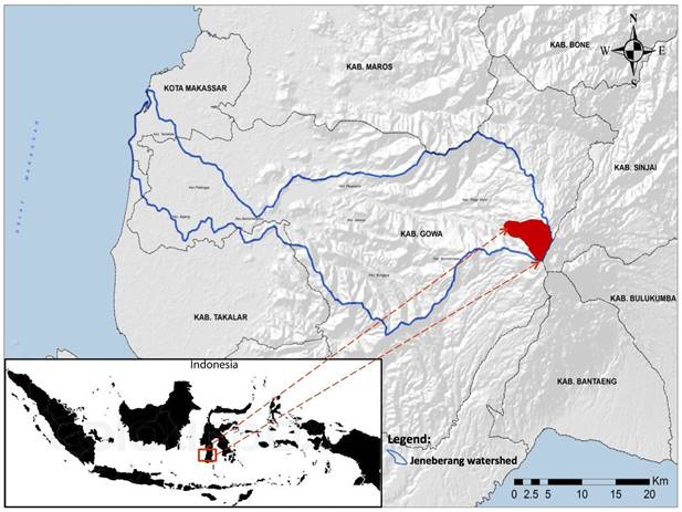
The Mt. Bawakaraeng Caldera is located in the province of South Sulawesi, Indonesia (Figure 1), at 2 830 masl. The morphology of Mt. Bawakaraeng is characterized by a high relief, extreme slopes, high degree of weathering, as well as events related to erosion such as soil movement and landslides (Hasnawir and Kubota, 2010). The vegetation of the mountainous areas is composed of natural forest and forest plantations of Pinus merkusii Jungh. & de Vriese. The basement around the area of Mt. Bawakaraeng, consists of Tonasa formation, Camba formation, Baturape-Cindako volcanic rocks, extrusive and intrusive rocks and Lompobattang volcanic formations, whose origin dates from the Paleogene to the Quaternary period.
The soils in the study area are Andosols and are formed with volcanic materials; many have excellent internal drainage, due to their high porosity and their occurrence in high-elevation positions. The specific gravity of the soil is 2.70, the porosity is estimated between 66.7 % and 88.7 %, while the apparent density is low and not only on the surface of the land; it is typically> 900 kg m-3, but can be as low as 300 kg m-3, values that have been obtained in highly hydrated andosols (Hasnawir and Kubota, 2011).
Methods
Erosion risk analysis requires an interdisciplinary approach involving disciplines such as hydrology, geomorphology and pedology (Ghosh and Bhattacharya, 2012). In this case gully inventories related to debris flow disasters were used in the Mt. Bawakaraeng Caldera from 2007 to 2017. The inventory was based on information from the local government office in South Sulawesi, in field investigations and soil tests.
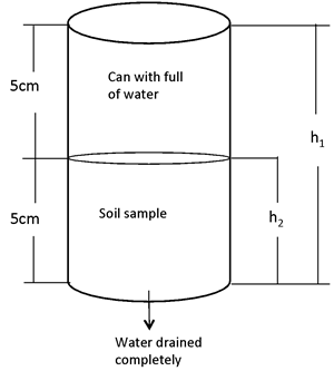
A standard laboratory analysis was performed according to the methods of the American Material and Testing Society (ASTM) to measure the particle size distribution. Three samples were taken per site (natural site, deposit of sediments in the upper part and deposit of sediments in the lower part). The difference between the particles (<75 μm) was determined with a No. 200 sieve. The standard method ASTM D 422 was applied to establish soil texture related to erosion. Soil permeability (k cm sec-1) was calculated using equation 1 and simplified equation 2, which establish the permeability capacity of a sample without disturbance. As permeability values increase, there is an increased risk of erosion.
This method is widely used to calculate the coefficient of permeability of a sample without disturbance, due to its practicality in the field (Paudel et al., 2008; Aditian y Kubota, 2014; Sánchez-Castillo et al. 2017a). To perform this method, two cylinders with the same dimensions are adjusted (Figure 2). One contains the soil sample, previously saturated, and the other is filled with water. Permeability is defined as the difference in time to drain all water from the upper can (Das, 1997):
Where:
a and A = Crosscutting area of the upper and lower cylinders
The equation was modified by replacing the values in equation 1, the permeability can be estimated as:
The Universal Soil Loss Equation (USLE) is an empirical method to determine relevant parameters among the many physical variables such as climate, soil profiles, relief, vegetation and land use and practices of area management, respectively indicated by the factors R, K, LS, C and P. The USLE equation was used in this investigation to describe the level of soil erosion that occurs in the Caldera of Mt. Bawakaraeng.
It is pertinent to specify that this equation can not be used to establish the risk of erosion in gullies, as indicated by Wischmeier (1976) in his discussion of the uses and misuses of the USLE, when he indicates that the equation can be used to estimate the average floor loss in a particular segment of a slope represented by a selective topographic factor. The parameters in the GIS framework include erosion factors such as rainfall, erodability, topography and coverage (Duru, 2016). The equation is expressed as follows:
Where:
A = Forecast of the average soil loss per unit area [ton ha-1 year-1]
R = Rain-runoff erosion factor (rain) in [MJ mm ha−1 hr−1 year-1]
K = Soil erodibility factor [ton ha hr ha−1·MJ−1·mm−1]
LS = Slope length and slope factor (without dimensions)
C = Coverage-management factor (radius of soil loss from a specific area)
P = Support factor in conservation (without dimensions)
Results and Disscusion
Soil analysis
The sieve analysis method covers the quantitative determination of the size distribution of soil particles (Table 1).
Table 1 Particle size distribution in the Caldera of Mt. Bawakaraeng (2017).
| Num. | Site. | Texture (%) | ||
| Sand | Silt | Clay | ||
| 1 | Natural site | 40 | 41 | 19 |
| 2 | Sedimento deposit (upper part) | 66 | 27 | 7 |
| 3 | Sedimento deposit (lower part) | 83 | 11 | 6 |
Sediment deposits have a higher percentage of sand than those of natural sites. The higher sand content describes a soil more prone to erosion, compared to those with lower values. It even indicates the possibility of erosion in gullies, when there are major events of rain in the area of sediment deposits.
The soil in eroded sites could have been formed by the interaction of many factors such as parental material, climate, weather, topography or relief and microbial activity. The relative influence of each factor depends on the geographical conditions and the location, but the combination of all of them, in general, determines the type of soil and the thickness that develops in any place (Huggett, 1997).
The results of soil permeability reached intervals from 0.0098 cm sec-1 to 0.0362 cm sec-1 (Table 2).
Table 2 Soil permeability of the three sites studied in the Mt. Bawakaraeng Caldera (2017).
| Num. | Site | Permeability (cm sec-1) |
|---|---|---|
| 1 | Natural site | 0.0098 |
| 2 | Sedimento deposit (upper part) | 0.0185 |
| 3 | Sedimento deposit (lower part) | 0.0362 |
As the permeability value becomes higher, erosion is more likely to occur. Sediment deposits in the lower part of the Caldera showed higher permeability values (Table 2).
Risk of Soil Erosion
The various factor maps of the USLE model (R, K, LS, C and P) generated in a GIS environment using Arc GIS 10.1 and ERDAS Imagine 2017 and the associated GIS packages were integrated with the USLE model to compute the erosion rate and its severity, which resulted in the soil erosion risk map of the Mt. Bawakaraeng Caldera. This erosion was classified as: very low (≤15 tons ha-1 year-1), low (16 - 60 tons ha-1 year-1), moderate (61 - 180 tons ha-1 year-1), high (181-480 tons ha-1 year-1) and very high (> 480 tons ha-1 year-1). The spatial distribution of the erosion risk class revealed that 3.53 % of the Caldera is low, 12.87 % very low, 64.06 % moderate, 0.06 % high and 19.49 % of the area is under a great risk of erosion (Table 3 and Figure 3 ).
Table 3 Risk of soil erosion in Mt. Bawakaraeng Caldera (2017).
| Risk of erosion |
Soil loss (ton ha-1 year-1) |
Area (ha) |
Percentage (%) |
| Very low | ≤ 15 | 122.32 | 3.53 |
| Low | 16 - 60 | 446.38 | 12.87 |
| Mild | 61 - 180 | 2 222.57 | 64.06 |
| High | 181 - 480 | 1.99 | 0.06 |
| Very high | > 480 | 676.02 | 19.49 |
| Total | 3 469.28 | 100.00 |
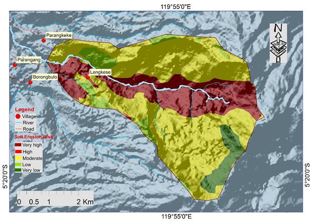
The highest values of risk of soil erosion are observed mainly on steep slopes adjoining drainage lines and rivers.
According to the results of the data collection of debris flow events from the government office of the province of South Sulawesi (Hazama-Brantas JO and Central River Region Pompengan-Jeneberang) there are 22 disasters related to erosion in gullies in the sediment deposits in Mt. Bawakaraeng from 2007 to 2017. The category of debris flow disaster was analyzed based on the volume of sediments and the impact of the debris flow. This impact includes damage to roads, destruction of agricultural land and sediment load to the catchment dam in the area (Table 4). Until now, there has not been a casual event. From the information provided by the communities living around the Caldera of Mt. Bawakaraeng no affectations have occurred. However, the incidence of debris flow promoted by gully erosion becomes a threat to people who carry out activities in the Caldera or its surroundings, which brings together 3 172 inhabitants in the vicinity.
Table 4 Disasters related to debris flow due to gully erosion in the Mt. Bawakaraeng Caldera.
| Num. | Date | Estimation of sediments (m3) |
Impact |
|---|---|---|---|
| 1 | 08-02-2007 | 240 000 | Sediment load to the dam |
| 2 | 16-02-2007 | 7 800 000 | Road damage and an hydraulic excavator, destruction of agricultural lands, sediment load to the dam |
| 3 | 27-12-2007 | 7 000 000 | Road damage, destruction of agricultural land, sediment load to the dam |
| 4 | 20-01-2008 | 1 200 000 | Destruction of agricultural land, sediment load to the dam |
| 5 | 03-02-2008 | 370 000 | Sediment load to the dam |
| 6 | 08-02-2008 | 2 800 000 | Destruction of agricultural land, sediment load to the dam |
| 7 | 22-12-2009 | 4 600 000 | Destruction of agricultural land, sediment load to the dam |
| 8 | 13-03-2010 | 3 000 000 | Destruction of agricultural land, sediment load to the dam |
| 9 | 24-12-2010 | 1 400 000 | Destruction of agricultural land, sediment load to the dam |
| 10 | 09-02-2011 | 500 000 | Sediment load to the dam |
| 11 | 26-02-2012 | 450 000 | Sediment load to the dam |
| 12 | 08-11-2012 | 280 000 | Sediment load to the dam |
| 13 | 24-12-2012 | 630 000 | Sediment load to the dam |
| 14 | 08-03-2013 | 1 100 000 | Destruction of agricultural land, sediment load to the dam |
| 15 | 13-12-2013 | 5 200 000 | Road damage, destruction of agricultural land, sediment load to the dam |
| 16 | 04-02-2014 | 420 000 | Sediment load to the dam |
| 17 | 03-01-2015 | 320 000 | Sediment load to the dam |
| 18 | 15-03-2015 | 1 200 000 | Destruction of agricultural land, sediment load to the dam |
| 19 | 04-04-2015 | 2 600 000 | Road damage, destruction of agricultural land, sediment load to the dam |
| 20 | 16-01-2016 | 480 000 | Sediment load to the dam |
| 21 | 21-02-2017 | 320 000 | Sediment load to the dam |
| 22 | 18-03-2017 | 280 000 | Sediment load to the dam |
Sources: Hazama-Brantas JO (2007-2010) and Pompengan-Jeneberang Central river region (2011-2017)
From the point of view of disaster prevention, the construction of sabo dams (dams built in the high parts of the mountains that prevent sediment runoff) would control erosion and sedimentation in the Mt Bawakaraeng Caldera; however, the procedure is expensive and time consuming, so it is necessary to have an early warning system in the area, especially in the rainy season when events of great intensity usually occur (November-April).
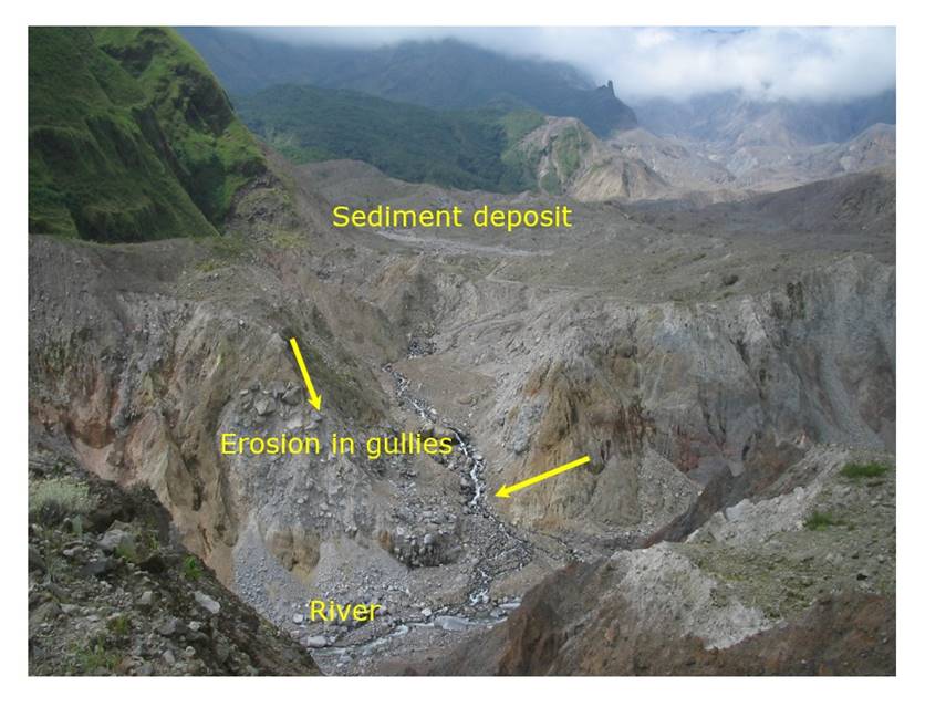
Hasnawir and Kubota (2010) reported that average rainfall above 3 000 mm per year occurs in the Mt. Bawakaraeng Caldera. Rainfall thresholds as an application of an early warning system for the prevention of sediment-related disasters according to the methodology proposed by Sánchez-Castillo et al. (2017b) could be developed in case there is not enough specific historical data in terms of time (minutes) and place. Figure 4 shows erosion in gullies in the sediment deposits at Mt. Bawakaraeng Caldera.
Conclusions
This study shows that the physical properties of the soil include the size of soil particles (with high sandy texture) and the permeability of the soil in the sediment deposits in the lower parts of the Mt. Bawakaraen Caldera they can cause erosion more easily, compared to the natural site and the upper parts of the place.
With the use of the USLE formula (R, K, LS, C and P) and the application of Geographic Information Systems, the risk of erosion can be analyzed in the place. The results revealed that 3.53 % of the Caldera has very low erosion, 12.87 % has low, 64.06 % moderate, 0.06 % has high and 19.49 % of the area presents a high risk of erosion. From 2007 to 2017, 22 disasters related to debris flow caused by gully erosion in the sediment deposits occurred. The impact of disasters includes damage to roads, destruction of agricultural land and sediment loads to the dam.
The high risk of gully erosion present in sediment deposits suggests the need for a disaster prevention system in the Mt. Bawakaraeng Caldera.
Referencias
Abdulfatai, I. A., I. A. Okunlola, Q. G. Akande, L. O. Mohoh and K. O. Ibrahim. 2014. Review of gully erosion in Nigeria: causes, impacts and possible solutions. Journal of Geomatics and Geosciences 2:125-129. doi: 10.12691/jgg-2-3-8. [ Links ]
Aditian, A. and T. Kubota. 2014. Influence of long-term increasing trend of maximum hourly rainfall on slope stability in forested area of Aso, Japan. Interpraevent. Nara, Japan. 477 p. [ Links ]
Das, B. M. 1997. Soil mechanics laboratory manual. Engineering Press. Austin,TX USA. pp. 5-23. [ Links ]
Dotterweich, M. 2008. The history of soil erosion and fluvial deposits in small catchments of central Europe: Deciphering the long-term interaction between humans and the environment. A review. Geomorphology 101:192-208. doi: 10.1016/j.geomorph.2008. 05.023. [ Links ]
Duru, U. 2016. Integrated Approach of GIS and USLE for Erosion Risk Analysis in the Sapanca Lake Watershed. International Journal Engineering Science 5(8):37-47. [ Links ]
Ghosh, S. and K. Bhattacharya. 2012. Multivariate erosion risk assessment of lateritic badlands of Birbhum (West Bengal, India): A case study. Journal of Earth System Science 121:1441-1454. doi: 10.1007/s12040-012-0243-1. [ Links ]
Hasnawir, H. M. and T. Kubota. 2010. Estimation of landslide velocity and warning of sediment disaster due to intense rainfall. International Journal of Ecology and Development 15:1-13. [ Links ]
Hasnawir, H. M. and T. Kubota. 2011. Landslide susceptibility evaluation by 3-D slope stability analysis. International Journal of Ecology and Development 19(1): 1-14. [ Links ]
Huggett, R. J. 1997. Environmental change: the evolving ecosphere. John Wiley & Sons. Routledge, London, UK. 387 p. [ Links ]
Ionita, I. 2006. Gully development in the Moldavian Plateau of Romania. Catena 68:133-140. doi: 10.1016/j.catena.2006.04.008. [ Links ]
Ionita, I., M. A. Fullen, W. Zgłobicki and J. Poesen. 2015. Gully erosion as a natural and human-induced hazard. Natural Hazards 79:S1 - S5. doi: 10.1007/s11069-015-1935-z. [ Links ]
Lesschen, J. P., K. Kok, P. H. Verburg and L. H. Cammeraat. 2007. Identification of vulnerable areas for gully erosion under different scenarios of land abandonment in Southeast Spain. Catena 71:110-121. doi: 10.1016/j.catena.2006.05.014. [ Links ]
Mararakanye, N. and P. D Sumner. 2017. Gully erosion: A comparison of contributing factors in two catchments in South Africa. Geomorphology 288:99-110. doi: 10.1016/j.geomorph.2017. 03.029 [ Links ]
Paudel, P. P, H. Omura, T. Kubota and B. Devkota. 2008. Characterization of Terrain Surface and Mechanisms of Shallow Landsliding in Upper Kurokawa Watershed, Mt Aso, Western Japan. Bulletin of Engineering Geology and the Environment 67(1):87-95. [ Links ]
Sánchez-Castillo, L., T. Kubota, I. Cantú S., T. Moriyama and H. M. Hasnawir. 2017a. A probability method of rainfall warning for sediment-related disaster in developing countries: a case study in Sierra Madre Oriental, Mexico. Naural Hazards 85(3):1893-1906. doi: 10.1007/s11069-016-2669-2. [ Links ]
Sánchez-Castillo, L., T. Kubota, I. Cantú-Silva and H. M. Hasnawir. 2017b. Influence of root reinforcement of forest species on the slope stability of Sierra Madre Oriental, Mexico. Journal of the Faculty of Agriculture 62(1): 177-181. [ Links ]
Su, Z., D. Xiong, Y. Dong, D. Yang, S. Zhang, B. Zhang, X. Zheng, J. Zhang and L. Shi. 2015. Influence of bare soil and cultivated land use types upstream of a bank gully on soil erosion rates and energy consumption for different gully erosion zones in the dry-hot valley region, Southwest China. Natural Hazards 79:183-202. doi: 10.1007/s11069-015-1722-x. [ Links ]
Wischmeier, W. H. 1976. Use and misuse of the universal soil loss equation. Journal of Soil and Water Conservation 31(1): 5-9. [ Links ]
Zabihi, M., F. Mirchooli, A. Motevalli, A. Khaledi-Darvishan, H. R. Pourghasemi and M. A. Zakeri, F. Sadighi. 2018. Spatial modelling of gully erosion in Mazandaran Province, northern Iran. Catena 161:1-13. doi: 10.1016/j.catena.2017.10.010. [ Links ]
Zakerinejad, R. and M. Maerker. 2015. An integrated assessment of soil erosion dynamics with special emphasis on gully erosion in the Mazayjan basin, southwestern Iran. Natural Hazards 79:25-50. doi: 10.1007/s11069-015-1700-3. [ Links ]
Zgłobicki, W., R. Kołodyńska-Gawrysiak, L. Gawrysiak. 2014. Gully erosion as a natural hazard: the educational role of geotourism. Natural Hazards 79:159-181. doi: 10.1007/s11069-014-1505-9. [ Links ]
Received: March 13, 2018; Accepted: September 24, 2018
 Este es un artículo publicado en acceso abierto bajo una licencia Creative Commons
