


Serviços Personalizados
Journal
Artigo
 texto em
  Inglês (pdf)
 Artigo em XML
 Referências do artigo
 Enviar este artigo por email
Indicadores
-
 Citado por SciELO
 -
 Acessos
Links relacionados
-
 Similares em
SciELO
Similares em
SciELO
Compartilhar

 Permalink
Revista mexicana de ciencias forestales
versão impressa ISSN 2007-1132
Rev. mex. de cienc. forestales vol.9 no.49 México Set./Out. 2018
https://doi.org/10.29298/rmcf.v9i49.128
Articles
Hydroclimatic Behavior of Conifers at Cerro El Potosí, Nuevo León, Mexico
1Centro Nacional de Investigación Disciplinaria en Relación Agua, Suelo, Planta, Atmósfera, INIFAP. México.
2Instituto de Geografía, UNAM. México.
3Facultad de Ciencias Forestales, UANL. México.
Cerro El Potosi (El Potosí Hill) (CPO) has an elevation gradient from 2 200 to 3 719 m and is the habitat of a variety of conifers. The objectives of this study were to 1) integrate a dendrochronological network composed of Pinus culminicola, Pinus hartwegii, Pseudotsuga menziesii, and Pinus greggii; 2) develop a representative rainfall reconstruction, and 3) analyze the influence of atmospheric circulation phenomena on the interannual and multiannual rainfall variability at CPO. In order to fulfill these objectives, four climate-sensitive chronologies were developed, the longest one (1420-2010) being for Pinus hartwegii, and the shortest (1850-2010), for Pinus greggii. The association between chronologies indicates a common climatic signal, as corroborated by the Principal Component Analysis. A representative chronology for different elevations of CPO covering the 1700-2010 period was developed and used to reconstruct the January-September seasonal precipitation. The driest years in the reconstruction were 1785 and 1801, while the wettest years were 1791, 1832, and 1911. The El Niño Southern Oscillation (ENSO) was found to exert a significant influence on rainfall (r= 0.53, p<0.01), through the Tropical Rainfall Index (TRI). The influence of hurricanes detected on the late wood chronologies indicates the potential to analyze the historical impact of this atmospheric disturbance on the production of ecosystem services for the region.
Key words: Conifers; dendrochronology; El Niño Southern Oscillation; atmospheric circulation patterns; hydroclimate; climate variability
El Cerro Potosí (CPO) se caracteriza por un gradiente altitudinal de 2 200 a 3 719 m y por ser hábitat de diversas coníferas. Los objetivos de este estudio fueron: 1) generar una red dendrocronológica de Pinus culminicola, Pinus hartwegii, Pseudotsuga menziesii y Pinus greggii; 2) desarrollar una reconstrucción de lluvia estacional; y 3) determinar la influencia de fenómenos atmosféricos de circulación general sobre la variabilidad interanual y multianual de la precipitación en CPO. Para lograr esos objetivos, con métodos dendrocronológicos se generaron cuatro cronologías climáticamente sensitivas; la más extensa (1420-2010) fue de Pinus hartwegii, y las más corta (1850-2010), de Pinus greggii. La asociación entre series dendrocronológicas mostró una respuesta climática común y mediante componentes principales. Se integró una serie representativa de los diversos estratos de elevación, que cubre el período 1700-2010. La reconstrucción de lluvia estacional enero-septiembre detectó que los años más secos fueron 1785 y 1801, y los más húmedos, 1791, 1832 y 1911, con una influencia significativa (r= 0.53, p<0.01) del Niño Oscilación del Sur (ENSO), a través del índice de lluvia tropical (TRI). La influencia de huracanes detectada en las series de madera tardía constituye una alternativa para analizar, históricamente, la influencia de estos fenómenos atmosféricos en el crecimiento de las especies y en la producción de servicios hidrológicos para la región.
Palabras clave: Coníferas; dendrocronología; El Niño Oscilación del Sur; fenómenos atmosféricos circulatorios; hidroclima; variabilidad climática
Introduction
It is crucial to understand the hydroclimatic variability of the sky islands from the ecological and social point of view, particularly when these sites are rich in biological diversity, with the presence of endemic species, a high supply of hydric resources, and other ecosystem services that are essential to the well-being of society. One of these sites in northeastern Mexico is Cerro El Potosí (CPO), located in the central-southern part of the state of Nuevo León. This hill is part of the Eastern Sierra Madre; at an altitude gradient of 2 000 to 3 721 m, has a surface area of over 1 000 km2, and is the ridgeline dividing three watersheds that drain toward the Gulf of Mexico and provide hydric resource for the social and economic development of human settlements in the states of Nuevo León and Tamaulipas (INEGI, 1986).
The diversity of conifers present in the various altitude floors of CPO is characterized by including drought-tolerant species on its lower stratum and various conifers, with greater water requirements, at higher elevations, render this area a natural landscape rich in biodiversity for analyzing the influence of the climate on the growth behavior of the taxa present in it, as well as the effect of disturbances caused by fires and by soil use changes; an example of the former is the 1998 fire, which significantly reduced the population of the endemic taxon Pinus culminicola Andresen & Beaman to less than 30 ha (Jiménez et al., 2003).
The existence of tree species that are representative of the various altitudes at CPO constitutes an excellent opportunity to generate a dendrochronological network and carry out dendroclimatic reconstructions that may allow a historical analysis of the hydroclimatic variability and its influence on the availability of water for those human settlements that depend on it.
The closeness of CPO to the Gulf of Mexico may influence the development of the species and the production of hydric resources, due to the presence of trade winds, cold fronts and hurricanes for which the high peaks of the Eastern Sierra Madre are a physical barrier on which they discharge moisture and where they dilute. General circulation atmospheric phenomena, such as the Atlantic Multidecadal Oscillation (AMO), the El Niño Southern Oscillation (ENSO), and the Pacific Decadal Oscillation (PDO) favor the occurrence of extreme hydroclimatic events in northeastern Mexico (Villanueva-Diaz et al. 2007; Méndez and Magaña, 2010; Stahle et al. 2016). This is evidenced by the droughts which in the past have caused food dearth and famine (García, 1997), a situation which today is rendered more serious by global warming (Seager et al., 2009).
The research questions of this study were: 1) whether or not there is a common response to the climate among the species present at the various altitudes on CPO, and 2) whether or not the interannual and multiannual climate variability detected in the chronologies is significantly influenced by phenomena related to the general atmospheric circulation phenomena.
In order to answer these questions, the present study pursued the following objectives: 1) to generate a dendrochronological network of the tree species that are representative of the altitude gradient of CPO; 2) to analyze their climatic response, and 3) to develop a reconstruction of the precipitation that may allow analyzing its variability in time and determining the effect of various general atmospheric circulation phenomena on it.
The historical analysis and frequency of extreme hydroclimatic events is important for determining the frequency, duration and intensity of these events in order to establish preventive and abatement actions for the preservation of both the ecosystems and the hydric resources generated at CPO (INEGI, 1986).
Materials and Methods
Study area
Cerro El Potosí is one of the highest peaks of the Eastern Sierra Madre. Geographically, it is located in the Galeana municipality, in the central-southern part of the state of Nuevo León, at the extreme geographical coordinates 24º50’35” to 24º53’16” N and 100º13’16” to 100º15’12” W. Because its altitude gradient ranges between 2 000 m, at the base of the mountain, and 3 721 m at its peak, it has various types of climate, depending on the altitude and exposure; BS1kw”(e) semi-arid climates are predominant at the western exposure, with greater humidity at the eastern and northern exposures. According to García-Arévalo and González-Elizondo (1991), the climate of the mountain is E(T)H(e), cold and extreme (García, 2004), changing at lower altitudes, where the temperatures range between 7 and 14 °C, with annual precipitations of up to 400 mm (IMTA, 2013).
The hydrology of CPO is very significant, as this mountain is the source of the San Fernando river, which drains the runoffs of the San Fernando-Soto La Marina hydrological region that discharge into the Gulf of Mexico.
The vegetation is highly diverse; Pinus cembroides Zucc. and Pinus greggii Engelm. ex Parl. grow in the lower part of the mountain, followed by a mixed conifer forest composed of various pine species at a higher altitude, (Pinus ayacahuite Ehrenb. ex Schltdl., Pinus pseudostrobus Lindl.), Pseudotsuga menziesii (Mirb.) Franco and Abies vejarii Martínez. Pinus hartwegii Lindl. grows above 3 000 masl, sometimes associated with Pinus culminicola (Beaman and Andresen, 1966; Risking and Patterson, 1975).
Representative tree species of the various altitude floors of CPO were selected for dendrochronological purposes and in order to determine the influence that high and low frequency climate variations exert on their development. A Pinus culminicola population established on a shallow soil at a rocky site was located at the top of the mountain, at the coordinates 24o51’37.5” N and 100o13’56.8” W and at an altitude of 3 200 m. The associated species was Pinus hartwegii. However, in other sites almost pure populations of P. culminicola were found, but with high mortality of individuals due to the 1998 fire; for this reason, 50 trees were selected, and cross sections of both living and dead specimens were collected.
For Pinus hartwegii, two to three growth cores were obtained from 50 living trees in several locations near the P. culminicola populations; the geographical location of one of the sampled sites is 24o52’21.9” N, 100o13’56.4” W, at an altitude of 3 715 masl. As for Pseudotsuga menziesii, the growth cores corresponded to specimens from the site located at 24o49’58.8” N and 100o04’01.2” W, at 3 200 masl. As for the lower stratum, growth cores were collected from a site located at the coordinates 25o30’35.5” N and 100o29’00.120” W, and an altitude of 1 980 masl (Figure 1).

Figure 1 Geographical location of the species sampled for dendrochronological purposes at Cerro El Potosí, Nuevo León.
The samples were mounted, polished and dated using conventional dendrochronological techniques (Stokes and Smiley, 1968). Due to the irregular radial growth of P. culminicola, several radii were taken in each cross section in order to determine those with the least irregular growth. The total, early-wood and late-wood ring growth series were measured using a VELMEX measuring system at a resolution of 0.001 mm, and were then verified using the COFECHA software (Holmes, 1983; Grissino-Mayer, 2001). Subsequently, the measurement series were standardized using the ARSTAN software (Cook, 1987), firstly, with a negative exponential curve or a negative slope straight line, and secondly, with a flexible frequency curve with a 0.5 response and an N/2 wavelength, N being the length of the time series (Cook and Peters, 1981).
The statistics generated with the COFECHA and ARSTAN programs, such as the intercorrelation between series, medium sensitivity, signal/noise ratio and Expressed Population Signal (EPS) were compared among all the species involved. The dendrochronological series for each species were contrasted in the common period, through simple correlations and principal components, in order to generate a dendrochronological series that would be representative of the dominant climate conditions of the altitude gradient. A seasonal rainfall reconstruction was developed based on the response function between average climate records of the stations close to CPO, which were integrated into a characteristic climate series of the region (Table 1), and the dendrochronological series that is representative of the hill, and its interannual and multiannual variability was analyzed, as well as its similarity to other precipitation reconstructions for the region.
Table 1 Location of those meteorological stations near Cerro El Potosí whose influence on the behavior of the regional dendrochronological network was analyzed.
| Station | Latitude (degrees) |
Longitude (degrees) |
Altitude (m) |
Period (years) |
Distance to the study site (km) |
|---|---|---|---|---|---|
| El Potosí | 100.32 | 24.85 | 1 725 | 1956-2000 (45) | 9.3 |
| Raíces, Galeana | 100.20 | 24.57 | 1 800 | 1956-2001 (46) | 45.5 |
| Ciénega del Toro | 100.33 | 25.08 | 700 | 1956-2004 (49) | 60.5 |
| El Rusio | 100.45 | 24.72 | 1 750 | 1962-2001 (40) | 27.5 |
The influence of atmospheric circulation phenomena was determined by comparing the indexes of the dendrochronological series against the values of the Southern Oscillation Indexes (SOI) (Allan et al., 1996), Tropical Rain Index (TRI), an estimate of the variability of El Niño Southern Oscillation (Wright, 1979); Pacific Decadal Oscillation (PDO) (Mantua et al., 1997), Atlantic Multidecadal Oscillation (AMO) (Van Oldenborgh et al., 2009), and the Palmer Drought Severity Index (PDSI), reconstructed for northeastern Mexico (Stahle et al., 2016).
The late-wood dendrochronological series was compared to the presence of hurricanes that have impacted CPO or that have been detected within a radius of 50, 100 and 200 km. The effect was considered to be positive when the late-wood index was above 1.0, while there was no impact in those cases when the index was average (i.e. equal to 1.0) or below 1.0.
Results
Dendrochronological series
A total ring chronology of 254 years (1757-2010) was generated for the 75 sampled Pinus culminicola trees, with two sections per tree (150 cross sections). 58 series were used for a 590-year chronology (1420-2009) of Pinus hartwegii; this is the most extensive chronology, as this is the longest-living species at CPO. At intermediate altitudes, of approximately 3 200 m, early-wood, late-wood and total ring chronologies of Pseudotsuga menziesii, stretching between 1845 and 2010 were based on 190 dated series. The chronology of Pinus greggii, a species that is representative of the lower part of the mountain, and of which early-wood, late-wood and total ring series were obtained, covered the years from 1850 to 2010.
Certain dendrochronological parameters, such as the intercorrelation between series, which show common values ranging between 0.55 and 0.65; the mean sensitivity (0.15 to 0.65), first-order autocorrelation (0.6 to 0.8), and signal/noise ratio (the higher the value, the better) for the generated chronologies exhibited values within intervals considered as normal (Speer, 2010); the Expressed Population Signal (EPS) was also included, for climate reconstruction purposes (Table 2).
Table 2 Dendrochronological parameters and EPS of the chronologies generated for the altitude gradient of Cerro El Potosí
| Species | 1 Intercor. | 2 Mean Sens. | 3 Autocorr. | 4 S/N Ratio | 5 EPS>0.85 | Chronological Length (years) |
|---|---|---|---|---|---|---|
| Pinus culminicola Andresen & Beaman | 0.525 | 0.1927 | 0.344 | 6.488 | 1887-2010 (11 radios) | 1757-2010 |
| Pinus hartwegii Lindl. | 0.555 | 0.290 | 0.545 | 4.04 | 1713-2009 (16 radios) | 1420-2009 |
| Pseudotsuga menziesii (Mirb.) Franco | 0.70 | 0.51 | 0.239 | 46.4 | 1884-2009 (7 radios) | 1845-2010 |
| Pinus greggii Engelm. ex Parl. | 0.715 | 0.567 | 0.333 | 6.271 | 1930-2010 (7 radios) | 1850-2010 |
1Intercorrelation between series = Association between two series of data; 2Mean Sensitivity = Relative change in the width of the rings of one year in relation to the next; 3Autocorr = First-order autocorrelation, measure of the influence of the previous year on the growth of the present year; 4Signal/Noise Ratio (S/N) = Value of the amount of desired information in relation to the amount of undesired information; the higher the quotient, the stronger the desired signal; 5EPS = Climate variation contained in a finite sample size with respect to an infinite sample size (Wigley et al., 1984).
Despite the differences detected in the dendrochronological indexes for the compared species at the various altitudes of CPO, a similar behavior was detected between taxa, particularly in the decades 1860, 1890, 1900, 1920, 1950, 1970 and 2000, with indexes below the unit related to droughts, and with values above the unit associated to humid periods in the decades 1840, 1870, 1900, 1940 and 1960 (Figure 2).
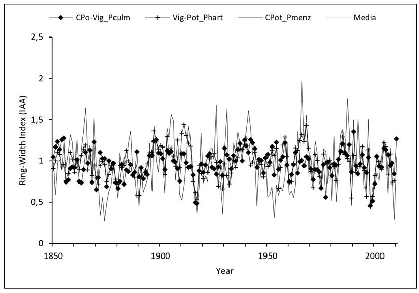
Figure 2 Comparison between the ring-width indexes of Pinus culminicola Andresen & Beaman, Pinus hartwegii Lindl., Pseudotsuga menziesii (Mirb.) Franco and Pinus greggii Engelm. ex Parl. present at the altitude gradient of Cerro El Potosí in Nuevo León.
When comparing the behavior of the indexes in terms of the variation in growth at the various altitudes of the mountain, the correlation for the overall ring series between Pinus culminicola and P. hartwegii during the common period from 1850 to 2010 was 0.68 (p<0.01). The value for this association diminished to 0.38 (p<0.01) when contrasted with Pseudotsuga menziesii, present at 2 500 masl, and to 0.17 (p<0.03) with Pinus greggii, located at 1 980 masl.
Relationship between growth rings and climate variables
The response of the representative growth series of CPO and the climate station integrated with the aforementioned stations (Table 1) shows that the overall standard ring chronology responded significantly to the January-September accumulated precipitation for the 1976-2004 period, with a correlation of 0.78 (p<0.01), which amounts to 61 % of the variance in seasonal accumulated precipitation in winter, spring and summer.
The precipitation records were calibrated for the total period of available records (1976-2004), as well as by 14-year sub-periods (1976-1989, 1990-2004). Based on this analysis, the ring width indexes were determined to account for 48 to 79 % of the variance in precipitation, while the total period accounts for 59 % of this variation. Therefore, the total period of available data was utilized for reconstruction purposes. The comparison between the parameters derived from the regression of the estimated precipitation sub-periods and the rainfall data recorded for the same sub-periods validates the robustness of the model. The reconstruction models surpassed the statistical validity tests when compared to independent precipitation values (Table 3).
Table 3 Statistics of the verification process for the reconstruction of the (January-September) seasonal precipitation.
| Period | Pearson’s correlation | 1 Error Reduction | 2 t-value | 3 Product of signs | 4 First significant difference |
|---|---|---|---|---|---|
| 1976-1989 | 0.72* | 0.63* | 2.9* | 2* | 4NS |
| 1990-2004 | 0.89* | 0.69* | 3.7* | 1* | 3* |
NS = Non-significant, probability above 5 % that the results may have occurred at random; *Significant, p<0.05; 1Any positive result indicates that the reconstruction contributes paleoclimatic information; 2Paired comparisons between the mean values of the observed data and those of the reconstructed data; 3Statistic considering both the sign and the magnitude of the differences between observations in relation to the mean; 4First negative difference in the sign test.
The calibration model derived from the regression analysis of the 1976-2004 period was:
Where:
Y t = Estimated precipitation of the January-September period (mm)
X t = Total ring index for a particular year
The reconstructed precipitation exhibited a high interannual and multiannual variation in the 311 reconstructed years (Figure 3).
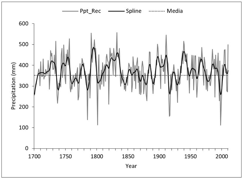
The dotted line represents the average of the January-September accumulated precipitation records; the gray line represents the interannual precipitation values, and the dark line is a flexible curve at decade level for highlighting low-frequency (multiannual) events
Figure 3 January-September reconstructed precipitation for CPO. The reconstructed period was adjusted to an EPS>0.85.
Influence of general atmospheric circulation phenomena
In an extensive region such as northeastern Mexico, the common response between growth ring series distributed at various sites of the Eastern Sierra Madre is due to the influence of general atmospheric circulation phenomena like ENSO, AMO, and PDO, which, directly or through tele-connections, affect the interannual and multiannual climate variation at a regional level.
The analysis of the impact of ENSO on CPO determined a close but negative relationship with the reconstructed (November-February) SOI, as well as with the instrumental SOI for May-December. This relationship between the chronology and the ENSO indexes improved when the January-April TRI (r= 0.53, p<0.0001, n= 103 years) was utilized (Figure 4). This suggests that the growth of the trees in that region may account for 27 % of the variability of the precipitation anomalies produced by ENSO during the winter-spring seasons.

Figure 4 Relationship between the total ring indexes of the regional chronology on CPO and the tropical rain index (TRI).
The relationship with the PDO was also significant, though for a longer period, which covered the months from March to December; a similar situation was determined based on the PDSI records for the summer (June-September), which exhibited a significant correlation (r=0.316, p<0.0007). No significant relationship with AMO was found to exist (Table 4).
Table 4 Association between the indexes of circulation phenomena and the total ring series representative of the higher part of the Cerro El Potosí in Nuevo León.
| Index | Months | Period (years) | Correlation | Probability |
|---|---|---|---|---|
| Reconstructed SOI1 | Nov-Feb | 1805-1977 (103) | -0.195 | 0.01 |
| SOI2 | May-Dec | 1876-2010 (135) | -0.198 | 0.02 |
| TRI3 | Jan-Apr | 1894-1996 (103) | 0.530 | 0.0001 |
| PDO4 | Mar-Dec | 1900-2010 (111) | 0.244 | 0.009 |
| AMO5 | Jul-Dec | 1856-2010 (155) | 0.187 | 0.02 |
| PDSI Instrum6 | Jun-Sep | 1901-2010 (110) | 0.316 | 0.0007 |
1Reconstructed SOI (Stahle et al., 1998); 2Instrumental SOI (Allan et al., 1996); 3TRI (Wright, 1979); 4PDO (Mantua et al., 1997); 5AMO (Van Oldenborgh et al., 2009); 6PDSI (Stahle et al., 2016).
Dendrochronological indexes and the influence of hurricanes
During the summer, one of the main sources of humidity at Cerro El Potosí are hurricanes. This influence seems to be most important in the formation of late wood of those species occurring on CPO. 40 % of the 24 cyclonic events recorded between 1887 and 2010 within a radius of 50 to 200 km, with CPO at the center, produced a higher annual ring width index (>1.0), while in the series of late Pseudotsuga menziesii and Pinus greggii wood, there was an increase above the average (>1.0) in at least 50 % of these events. The cyclones that occurred at a radius of 200 km in the years 1921, 1928, 1975 and 1999 had no impact on the ring-width index, which was below average (<1.0) for all taxa; therefore, although these phenomena may have been present in the region, they probably did not affect CPO.
Discussion
In regard to the dendrochronological parameters, those tree species that grow at the higher limits of the high mountains in Mexico, such as Pinus culminicola and Pinus hartwegii -despite their sensitivity to the climate, which is evident in the variation of its annual radial increase- are subjected to stressing conditions, such as shallow soils with a low fertility; constant, intense winds, and freezing temperatures. This situation induces a prostrated position of the trees, which favors irregular growths (Schweingruber, 1996), reducing the intercorrelation between series.
The dendrochronological parameters of the dated series -mean sensitivity, first-order autocorrelation and signal/noise ratio- were similar to those obtained for Pinus hartwegii in central and northern Mexico (Villanueva et al., 2015). However, the intercorrelation between series was lower than that of more climate-sensitive species like Pinus cembroides and Pseudotsuga menziesii, which occur in the neighboring mountains of the Eastern Sierra Madre (Constante et al., 2009).
The mean sensitivity parameter (0.193) was lower than that observed in other taxa present at close sites. The lowest mean sensitivity values in Pinus culminicola are ascribed to the irregularity in the growths, a behavior that has been cited for taxa dwelling in alpine ecosystems in various parts of the world, e.g. Juniperus monticola Martínez, in volcanoes in central Mexico (Villanueva-Díaz et al., 2016), for Polylepis tarapacana Phil., in South America (Argollo et al., 2004), and for various shrubs in Europe (Liang et al., 2010).
In the 311 years of reconstructed rainfall, the driest years were 1785 (139 mm), 1801 (114 mm) and 1998 (112 mm, with a precipitation below 40 % of the average recorded for January-September (352 mm). These years of rain scarcity were observed to occur in periods with several consecutive years of drought, which caused an economic crisis and brought about social issues across the country, as in the “Year of the Famine” (Florescano, 1980). The period between 1789 and 1810 has been well documented in Saltillo, Coahuila, for its shortage of basic grains, famine and high mortality of the livestock (García, 1997).
The humid years also occurred by episodes, with several consecutive years -such as 1791, 1832 and 1911- of precipitations above the average and 60 % above the reconstructed mean; in other years -namely 1734, 1756, 1939 and 2010-, the increase was closer to 50 %.
Although the region showed the significant influence of ENSO through SOI indexes, the main association with this phenomenon was determined based on the TRI for the January-April period, during which the representative chronology of the higher part of CPO accounted for 28 % of the anomalies in the rainfalls in the equatorial Pacific (Wright, 1979). The impact of this circulation phenomenon is not as high as in northern Mexico, where the relationship between the chronologies of early wood and the SOIs reach a maximum of 0.7 for the winter-spring seasonal period (Stahle et al., 1998; Villanueva et al., 2014). Other circulatory phenomena like PDO (r= 0.24, p<0.01, n= 111) and AMO (r = 0.187, p<0.02) exhibited a significant influence, which was nevertheless lower in the region. Studies on the influence of these phenomena in Mexico show an interaction that favors extremely dry events when they are in-phase (Elder et al., 2014) and increase the presence of hurricanes in the Gulf of Mexico (Wang et al., 2008; Méndez and Magaña, 2010).
The record of hurricanes at CPO indicated a positive influence on the growth of total wood of Pinus culminicola, but in particular, of the late wood of species like Pseudotsuga menziesii and Pinus greggii.
Conclusions
The dendrochronologial parameters of Pinus culminicola, Pinus hartwegii, Pseudotsuga menziesii and Pinus greggii at the various altitudes of Cerro El Potosí confirm the sensitivity of these species to climate, as well as the existence of climate events that affected the whole mountain with differentiated effects on their growths, but with similar tendencies, particularly in years with little precipitation.
Although in this study the longest-living species was Pinus hartwegii, its sensitivity to climate is lower than that of Pinus culminicola, which attains ages above 300 years and shows a high potential for carrying out rainfall reconstructions.
The significant association of the representative series of the higher part of CPO with the dendrochronological series of tree species distributed in the neighboring mountains, as well as with the growths of those species existing along the altitude gradient indicates that the taxa respond to the variation in precipitation, which affects CPO and other mountains of the Eastern Sierra Madre.
The great droughts that have taken place in the past, in cycles of approximately 50 years, may occur in the future, with magnified effects, due to a greater pressure on the hydric resources; for this reason, it is important to establish abatement actions in order to face these events.
Because Pinus culminicola and Pinus hartwegii grow at the higher arboreal limit of the highest peaks of the Eastern Sierra Madre, they are greatly relevant for the studies on climate change, as the increases in temperature may affect the availability of water and, therefore, impact their ecological stability.
The circulatory phenomenon that most influenced the hydroclimatic variation of CPO was ENSO; based on the TRI, it was determined to exert its strongest influence during the January-April seasonal period, when it accounted for 28 % of the annual radial increase of the tree species present there.
Unlike ENSO, which exerts more influence during the winter-spring period, the presence of hurricanes in mid-summer has a favorable impact on the annual growth of P. culminicola and P. hartwegii. This effect is more noticeable particularly in late-wood series, and, therefore, these may constitute a proxy for a historical understanding of the impact of hurricanes on CPO.
The development of dendrochronological networks in sky islands like CPO that may combine the hydroclimatic response across an altitude gradient makes it possible to analyze the variability of the climate, the frequency and the probability of extreme hydroclimatic events, and the impact of general atmospheric circulation patterns.
Acknowledgements
The authors are grateful for the support of the Instituto Nacional de Investigaciones Forestales, Agrícolas y Pecuarias (National Institute for Research on Forestry, Agriculture and Livestock), received through the fiscal projects: “Reconstruction of water flows and the influence of general circulation phenomena on the basins of the Mexican Pacific” and “Reconstruction of water flows and the influence of general circulation phenomena on the basins of the Western Sierra Madre”.
REFERENCES
Allan, R. J., J. Lindesay and D. Parker. 1996. El Niño/Southern Oscillation & climatic variability. CSIRO Publishing. Melbourne, Australia. 408 p. [ Links ]
Argollo, J., C. Soliz y R. Villaba. 2004. Potencial dendrocronológico de Polylepis tarapacana en los Andes Centrales de Bolivia. Ecología en Bolivia 39(1): 5-24. [ Links ]
Beaman, H. and W. J. Andresen. 1966. The vegetation, floristics and phytogeography of the summit of Cerro Potosí, Mexico. The American Midland Naturalist 75(1): 1-33. [ Links ]
Constante G., V., J. Villanueva D., J. Cerano P., E. H. Cornejo O. y S. Valencia M. 2009. Dendrocronología de Pinus cembroides Zucc. y reconstrucción de precipitación estacional para el sureste de Coahuila. Ciencia Forestal en México 34(106): 17-39. [ Links ]
Cook, E. R. and K. Peters. 1981. The smoothing spline: a new approach to standardizing forest interior tree-ring width series for dendroclimático studies. Tree-ring bulletin 47: 37-59. [ Links ]
Cook, E. R. 1987. The decomposition of tree-ring series for environmental studies. Tree-Ring Bulletin 47: 37-59. [ Links ]
Elder, C. R., R. C. Balling Jr., R. S. Cerveny and D. Krahenbuhl. 2014. Regional variability in drought as a function of the Atlantic Multidecadal Oscillation. Caribbean Journal of Science 48(1): 31-43. [ Links ]
Florescano, E. 1980. Una historia olvidada: la sequía en México. Nexos 32: 9-13. [ Links ]
García-Arévalo, A. y S. González-Elizondo. 1991. Flora y vegetación de la cima del Cerro Potosí, Nuevo León, México. Acta Botánica Mexicana 13: 53-74. [ Links ]
García H., A. 1997. Alternativas ante las sequías de 1789-1810 en la villa de Saltillo, Coahuila, México. In: García A., V. (coord.). Historia y Desastres en América Latina. Vol. II. Red de Estudios Sociales en América Latina. Editorial. México, D.F., México. pp. 148-169. [ Links ]
García, E. 2004. Modificaciones al sistema de clasificación climática de Köppen para adaptarlo a las condiciones de la república mexicana. Series Libros Núm. 6. 5a edición. Instituto de Geografía, Universidad Nacional Autónoma de México. México, D.F., México. 90 p. [ Links ]
Grissino-Mayer, H. D. 2001. Evaluating crossdating accuracy: a manual and tutorial for the computer program COFECHA. Tree Ring Research 57(2): 205-221. [ Links ]
Holmes, R. 1983. Computer-assisted quality control in tree-ring dating and measurement. Tree-Ring Bulletin 43: 69-78. [ Links ]
Instituto Mexicano de Tecnología del Agua (IMTA). 2013. ERIC III Ver. 3.2. Extractor Rápido de Información Climatológica. IMTA. Jiutepec, Morelos. n/p. [ Links ]
Instituto Nacional de Estadística y Geografía (INEGI). 1986. Síntesis geográfica del estado de Nuevo León. Instituto Nacional de Estadística, Geografía e Informática. México, D.F., México. 171 p. [ Links ]
Jiménez, J., O. Aguirre, E. Estrada y E. Jurado. 2003. Restauración de Pinus culminicola en el área protegida Cerro Potosí, México. Resumen in extenso. In: Food and Agricultural Organization of the United Nations (FAO). (comps.). XII Congreso Forestal Mundial. 21 al 28 de septiembre. Quebec, Canadá. 6 p. [ Links ]
Liang, E., X. Shao, D. Eckstein and X. Liu. 2010. Spatial variability of tree growth along a latitudinal transect in the Qilian Mountains, northeastern Tibetan Plateau. Canadian Journal of Forest Research 40(2): 200-211. [ Links ]
Mantua, N. J., S. R. Hare, Y. Zhang, J. M. Wallace and R. C. Francis. 1997. A Pacific interdecadal climate oscillation with impacts on salmon production. Bulletin of the American Meteorological Society 78: 1069-1079. [ Links ]
Méndez, M. and V. Magaña. 2010. Regional aspects of prolonged meteorological droughts over Mexico and Central America. American Meteorological Society 23: 1175-1188. [ Links ]
Riskind, D. H. and T. F. Patterson. 1975. Distributional and ecological notes on Pinus culminicola. Madroño 23(3): 159-161. [ Links ]
Schweingruber, F. H. 1996. Tree rings and environment. Dendroeocology. Birmensdorf, Swiss Federal Institute for Forest, Snow and Landscape Research. Berne, Stuttgart, Viena, Haupt. 609 p. [ Links ]
Seager, R., M. Ting, M. Davis, M. Cane, N. Naik, J. Nakumara, C. Li, E. Cook and D. W. Stahle. 2009. Mexican drought: an observational modeling and tree ring study of variability and climate change. Atmósfera 22 (1): 1-31. [ Links ]
Speer, J. H. 2010. Fundamentals of tree-ring research. University of Arizona Press. Ciudad, AZ USA. 368 p. [ Links ]
Stahle, D. W., R. D. D’Arrigo, P. J. Krusic, M. K. Cleaveland, E. R. Cook, R. J. Allan, J. E. Cole, R. B. Dunbar, M. D. Therrell, D. A. Gay, M. D. Moore, M. A. Stokes, B. T. Burns, J. Villanueva-Diaz and L. C. Thompson. 1998. Experimental dendroclimatic reconstruction of the Southern Oscillation. Bulletin of the American Meteorological Society 79(10): 2137-2152. [ Links ]
Stahle, D. W., E. R. Cook, D. J. Burnette, J. Villanueva, J. Cerano, J. N. Burns, D. Griffin, B. I. Cook, R. Acuña, M. C. A. Torbenson, P. Szejner and I. M. Howard. 2016. The Mexican drought atlas: tree-ring reconstructions of the soil moisture balance during the late pre-Hispanic, colonial, and modern eras. Quaternary Science Review 149: 34-60. [ Links ]
Stokes, M. A. and T. L. Smiley. 1968. An introduction to the Tree-Ring Dating. The University of Arizona Press. Tucson, AZ USA. 73 p. [ Links ]
Van Oldenborgh, G. J., L. A. Te Raa, H. A. Dijkstra and S. Y. Philip. 2009. Frequency- or amplitude-dependent effects of the Atlantic meridional overturning on the tropical Pacific Ocean. Ocean Science 5: 293-301. [ Links ]
Villanueva-Diaz, J, D. W. Stahle, B. H. Luckman, J. Cerano-Paredes, M. D. Therrell, M. K. Cleaveland and E. Cornejo-Oviedo. 2007. Winter-spring precipitation reconstructions from tree rings for northeast Mexico. Climatic Change 83(1-2): 117-131. [ Links ]
Villanueva D., J., J. Cerano P., A. Gómez G., L. U. Castruita E., D. W. Stahle y J. A. Ruiz C. 2014. Volúmenes reconstruidos en presas del Valle del Yaqui con anillos anuales de coníferas. Revista Mexicana de Ciencias Agrícolas 10: 1977-1991. [ Links ]
Villanueva D., J., J. Cerano P., L. Vázquez S., D. W. Stahle, P. Z. Fulé, L. L. Yocom, O. Franco R. y J. A. Ruiz C. 2015. Red dendrocronológica de pino de altura (Pinus hartwegii Lindl.) para estudios dendroclimáticos en el noreste y centro de México. Boletín del Instituto de Geografía 86: 5-14. [ Links ]
Villanueva-Díaz, J., L. Vázquez-Selem, A. Gómez-Guerrero, J. Cerano-Paredes, N. A. Aguirre-González y O. Franco-Ramos. 2016. Potencial dendrocronológico de Juniperus montícola Martínez en el Monte Tlaloc, México. Revista Fitotecnia Mexicana 39(2): 175-185. [ Links ]
Wang, C. L., S. K. Lee and D. B. Endfield. 2008. Atylantic warm pool acting as a link between Atlantic Multidecadal Oscillation and Atlantic tropical cyclone activity. Geochemestry, Geophysics, Geosystems 9(5):1-17. doi: 10.1029/2007GC001809. [ Links ]
Wigley, T. M. L., K. R. Brifa and P. D. Jones. 1984. On the average value of correlated time series, with applications in dendroclimatology and hydrometeorology. American Meteorological Society 23: 201-213. [ Links ]
Wright, P. B. 1979. Persistance of rainfall anomalies in the Central Pacific. Nature 277: 371-374. [ Links ]
Received: December 15, 2017; Accepted: September 03, 2018
 Este es un artículo publicado en acceso abierto bajo una licencia Creative Commons
