


Servicios Personalizados
Revista
Articulo
 texto en
  Inglés (pdf)
 Artículo en XML
 Referencias del artículo
 Enviar artículo por email
Indicadores
-
 Citado por SciELO
 -
 Accesos
Links relacionados
-
 Similares en
SciELO
Similares en
SciELO
Compartir

 Permalink
Revista mexicana de ciencias forestales
versión impresa ISSN 2007-1132
Rev. mex. de cienc. forestales vol.9 no.48 México jul./ago. 2018
https://doi.org/10.29298/rmcf.v8i48.121
Articles
Runoff and sediment production in oak forests of the Sierra Madre Oriental, Mexico
1Facultad de Ciencias Sociales y Humanidades. Universidad Autónoma de San Luis Potosí. México.
2Centro de Geociencias. Universidad Nacional Autónoma de México. México.
3Instituto de Investigaciones de Zonas Desérticas. Universidad Autónoma de San Luis Potosí. México.
In natural conditions, undisturbed forest soils have high infiltration rates and runoff and erosion are relatively low, but these may be modified after burning. Infiltration capacity and soil aggregate stability tend to decline in soils of burned areas, which make them prone to increased infiltration and soil erosion. In this study, the effect of three post-fire conditions (high and moderate fire severity and unburnt) on hydrological and erosional properties was evaluated using rainfall simulation in oak forests of Sierra Madre Oriental, Mexico. Additionally, soil surface properties affecting runoff and sediment production were identified by means of regression trees. Average runoff, peak runoff and sediment production were greater in high fire severity plots than in moderate severity and unburned plots. Soil surface roughness, slope, litter cover and stone fragments cover were the main surface characteristics that influenced runoff in the studied burned areas. It can be concluded that fire severity and soil surface characteristics are fundamental variables to consider for a better understanding of hydrological surface processes in forests affected by wildland fires. These results can be used to identify priority mitigation and restoration areas in the region.
Key words: Runoff; soil erosion; wildland fire; infiltration; fire severity; rainfall simulation
En condiciones de disturbio mínimo, los suelos de los ecosistemas forestales tienen tasas de infiltración altas, y por lo tanto, la magnitud de la escorrentía y la erosión es baja, situación que puede revertirse por el fuego. El objetivo del presente estudio fue evaluar el efecto de tres niveles de severidad de incendios en la escorrentía y producción de sedimentos, mediante simulación de lluvia en encinares de la Sierra Madre Oriental. Por medio de árboles de regresión se identificaron las características de la superficie del suelo que más influencia tienen sobre ambos procesos. La escorrentía promedio, la escorrentía máxima y la producción de sedimentos fueron mayores en áreas con severidad de incendio alta, que en las áreas con severidad moderada y áreas sin quemar. Las variables de con más repercusión fueron la rugosidad de la superficie del suelo, la pendiente y las coberturas de mantillo y fragmentos de rocas. Se concluye que la severidad de incendios es fundamental para entender los procesos hidrológicos superficiales y de erosión, y que las características de la superficie del suelo modificadas por el fuego, como la cobertura y la microtopografía afectan la escorrentía y producción de sedimentos en áreas quemadas. Los resultados son útiles para identificar áreas prioritarias para la restauración de suelos y definir acciones de mitigación de la erosión.
Palabras clave: Escorrentía; erosión del suelo; incendio forestal; infiltración; severidad del fuego; simulación de lluvia
Introduction
In most forest ecosystems, fire is a natural disturb factor which, also, is a basic element that helps in its structural formation (Turner and Dale, 1988). However, human influence in the modification of fire regimes has fostered environmental problems such as biological diversity loss, soil degradation and alteration of the hydrologic cycle (Doerr et al., 2006).
Fire modifies some properties of the soil, of which, physical in particular, are one of the factors that favor the increase of runoff and erosion in forests and scrublands (Shakesby, 2011). One of the ways to evaluate the impact of a fire is by estimating its severity, which indicates the degree of change in soil properties and the loss of vegetation and organic matter (Keeley, 2009).
Therefore, the changes in the hydrological response of the soil caused by the amount of heat released during the fire have a direct relationship with the differences observed in the severity of the fire (Vieira et al., 2015). High severity is related to the consumption and partial or total destruction of organic matter, which reduces the amount of vegetation and superficial soil cover (Keeley, 2009). This reduction exposes the soil to the effects of the kinetic energy of the raindrops, decreases the stability of the soil aggregates and can cause hydrophobicity (Robichaud et al., 2016), which increases runoff and erosion. The effects of fires in the soil persist depending on certain factors such as the capacity of vegetation recovery, the post-fire weather conditions, the availability of sediments for transport and the morphology of the hillsides (Vieira et al., 2015).
Changes in infiltration, runoff and erosion as a consequence of forest fires have been studied mostly in pine forests and shrubs in the United States of America and Mediterranean regions of Spain and Portugal. In general terms, soils affected by fires reduce their infiltration capacity and, therefore, increase runoff (Ferreira et al., 2005); thus, the soils of burned areas are more prone to water erosion in the rainy seasons following fires (Johansen et al., 2001). The increase in runoff and erosion as a consequence of a fire is verified in greater magnitude during the first years, and most of the studies record that erosion rates take between three and nine years to return to the pre-fire condition (Robichaud et al., 2000).
However, the hydrodynamic properties of the soil and its relation to the severity of fires have not been studied extensively in other countries and ecosystems (Shakesby, 2011). For Mexico, there are few published works that relate to the subject, and have focused on the relationships between prescribed burns and runoff in Chihuahua pine forests (Alanis et al., 2000) and the effects of the severity of fires in the hydrophobicity and stability of soil aggregates (Jordán et al., 2011). This lack of research highlights the great gap in the knowledge of the impacts of fires on hydrological and erosion processes in Mexico.
For this reason, the aim of this work was to analyze the effect of the severity of forest fires (moderate and high severity, as well as unburned areas used as reference) in the medium term (<3 years since the fire) in the hydrological (average run-off and maximum run-off) and erosion response (sediment production) by rainfall simulation tests with high intensity in two holm oaks of the Sierra Madre Oriental of San Luis Potosí. The null hypothesis is that the runoff and sediment production are modified according to the severity of fire, and that, to a greater severity, runoff and sediment production increase with respect to the unburned areas.
Materials and Methods
Study area and site selection
The study area comprised the central part of the ecological corridor of the Sierra Madre Oriental, within the state of San Luis Potosí, corresponding to the Alaquines and Lagunillas municipalities (Figure 1). These municipalities are located in an area of high risk of fires, according to the Ley para la Prevención y Manejo Integral e Institucional de los Incendios Forestales para el Estado de San Luis Potosí (Law for the Prevention and Integral and Institutional Management of Forest Fires for the State of San Luis Potosí).
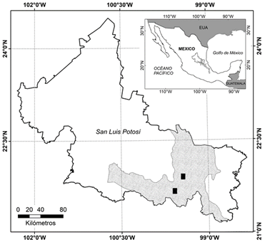
Figure 1 Location of the study sites (black rectangles) within the Ecological Corridor of the Sierra Madre Oriental in the state of San Luis Potosí, Mexico (shaded area).
The physiography is mostly represented, by mountain ranges, and in smaller proportion by canyons, valleys and plains whose altitude varies between 250 and 1 800 m. The geological conformation of the main substrates is constituted by limestone rocks that have given rise to karstic geoforms as a consequence of the dissolution of such rocks.
The prevailing climates in the study area according to the Köppen classification modified by García (1973), are the warm sub-humid (A) C (Wo), with average annual precipitation between 800 and 1 200 mm and average annual temperature between 22 and 24 °C; and the semi-warm sub-humid climate (A) C (W2), with annual average precipitation between 1 200 and 1 500 mm and average annual temperature between 18 and 22 °C.
The main types of vegetation are the oak forest, the submontane scrub and the low and medium deciduous and subdeciduous forests. Agriculture and livestock are practiced extensively and sugarcane is the first crop in the region (Rzedowski, 2006).
The hydrological response and the production of sediments were characterized in two sites burned with a time from the fire less than three years until the time of measurements. Both sites were located in soils of the Leptosol type and with similar characteristics in terms of topography and vegetation (Table 1).
Table 1 Characteristics of the study sites.
| Feature | Site1 | Site 2 |
|---|---|---|
| Altitude (m) | 1 100 | 1 300 |
| Slope (%) | 32.0 | 26.0 |
| Slope facing | SE | S |
| Soil texture* | Clay loam | Gross clay |
| Type of vegetation and dominant species | Oak forest (Quercus polymorpha Schltdl. & Cham.) | Oak forest (Quercus germana Schltdl. & Cham) |
| Time since the fire occurred (months) | 10 | 31 |
*Soil texture is corresponding to the classification system of the International Society (1929).
At each site, areas with three post-fire conditions were visually identified according to Odion and Hanson (2006): (1) high severity, where woody vegetation was burned by more than 80 %, (2) severity moderate, where the fire affected between 40 % and 80 % of the woody vegetation and (3) areas with minimal evidence of fire or without burning, where the woody vegetation was affected in less than 10 %.
Condition of the soil surface and rain simulations
Five areas of each post-fire condition were selected within each site to establish rainfall simulation plots and to evaluate runoff and sediment production. Prior to the rain simulation tests, the proportion (%) of the coverage of plants, mulch and rock fragments that covered each rain simulation plot was estimated visually, and the sum of all these components represented the total coverage. Each plot was photographed and the coverage of each component in the cabinet was verified by digital classification. The roughness of the surface was measured with a 3 mm metal chain arranged along the simulation plot (Saleh, 1993) and the slope with a portable Petrul level. Two samples of surface soil (0-5 cm) adjacent to each rainfall simulation plot were taken to determine moisture content, apparent density (g cm-3) with the test-tube method and fractions (%) of sand, silt and clay by granulometric analysis with the pipette method. All rainfall simulations were carried out in the spring of 2014, when the humidity above the ground in its upper layer was <8% (w/w).
Cornell-type infiltrometers were used, which are portable rain simulators (Cornell Sprinkle Infiltrometer) (Ogden et al., 1997), which are placed in circular plots of 457.3 cm2 to apply rainwater (Figure 2). These simulators are robust, practical and easily transported in difficult terrain. They have a water tank (20 L) that contains a pipette that allows the passage of air during the simulation tests and also serves to define the intensity of the rain if its height is modified inside the tank. The rainwater leaves the simulator by gravity, and, when passing through a capillary system formed by small spiral tubes, it forms drops that fall to the plot delimited by a metallic ring inserted into the ground at a depth of 7 cm, which has an exit for the collection of runoff. For the purposes of the study, the rain simulators were calibrated to apply an average of 287.5 mm h-1 (SD = 57.8 mm h-1) of water during 30 min, which represents high intensity rainfall events that produce runoff and erosion in the region. Similar rainfall application rates have been used to produce runoff with this type of simulators (Mohammadshirazi et al., 2016; Santi et al., 2016).
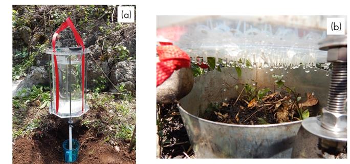
a) Infiltrometer installed in the study site; b) Detail of the interior of a runoff measurement plot.
Figure 2 Cornell-type infiltrometer with rain simulator.
Once runoff occurred, its volume was measured every minute until the end of the rain simulation. The runoff rate was graphed with the lasting time of the simulation to generate hydrographs for each of the post-fire conditions. The average runoff and maximum runoff rates (the highest runoff value reached during the rainfall simulation in mm h-1) were calculated for each rainfall simulation plot. Subsamples of 150 mL of the runoff produced in each plot were collected and dried in the soil laboratory of the Desert Areas Research Institute of the UASLP at 105 °C for 24 h to determine the total sediment production (g m-2).
Data analysis
To detect differences between runoff curves, hydrographs were grouped by post-fire condition, and were compared using 1 000 permutation tests with the Growthcurve option of the Statmode library available in the R program (R Development Core Team, 2015).
To quantify differences in the average runoff rate, the maximum runoff rate and the total sediment production in the rain simulation plots, a Kruskal-Wallis nonparametric variance analysis was used because the data did not follow a normal distribution. Contrast pairs were used to identify differences between post-fire conditions and the values of statistical significance for both analyzes were specified as P <0.05.
To identify the main characteristics of the soil surface that influence the average runoff and sediment production, all the data of the three post-fire conditions were integrated and regression trees were built with the Rpart library in the R program.
This non-parametric method fragmented, recursively, a multi-dimensional space defined by explanatory variables in subgroups as homogeneous as possible to minimize the variance. The average runoff and sediment production data were divided into internal nodes with the explanatory variables ordered hierarchically and descending to the left and right of the main node, and generated terminal nodes based on the thresholds defined by the explanatory variables.
Results
Condition of the soil surface
The coverage of herbaceous, mulch and total cover were greater in the unburned plots, in comparison with the plots of moderate and high severity (P <0.005, Table 2). These coverings of herbaceous, mulch and total cover were similar in the plots of moderate and high severity (P> 0.05), and the coverage of rocks was similar among the three post-fire conditions. The slope in the rain simulation plots was similar in the three post-fire conditions (P> 0.05); however, the roughness was greater in the unburned plots, followed in descending order, of the moderate and high severities (P <0.001).
Table 2 Characteristics of the soil surface measured in simulation plots of rain by post-fire condition.
| Feature of the soil surface | Post-fire condition | ||
|---|---|---|---|
| Unburned | Moderate severity |
High severity | |
| Plant coverage (%) | 22.50 (4.22) b | 8.00 (4.36) a | 3.50 (1.83) a |
| Mulch coverage (%) | 66.00 (4.99) b | 27.00 (5.12) a | 19.50 (3.34) a |
| Rock fragment coverage (%) | 3.00 (1.53) a | 1.50 (1.07) a | 4.50 (1.90) a |
| Total coverage (%) | 91.50 (2.24) b | 36.50 (4.6) a | 27.50 (4.90) a |
| Naked soil (%) | 8.50 (2.24) a | 63.50 (5.27) b | 72.50 (4.90) b |
| Slope (%) | 16.30 (2.2) a | 14.20 (2.5) a | 17.10 (4.0) a |
| Roughness index (dimensionless) | 0.59 (0.045) c | 0.41 (0.020) b | 0.31 (0.014) a |
| Apparent density (g cm−3) | 0.95 (0.19) a | 1.12 (0.30) a | 1.19 (0.24) a |
| Sand fractions (%) | 30.50 (1.60) a | 31.00 (1.95) a | 34.10 (1.12) a |
Average values are shown (± EE).
Different letters within each row indicate significant differences between post-fire conditions (P <0.05). n = 10 for each post-fire condition.
Runoff and sediment production in post-fire conditions
In the three post-fire conditions, the runoff started within the first two minutes after the start of the rain simulations. However, the hydrographic curves in the high severity had higher runoff values than in the moderate severity and the unburned plots (permutation tests, P <0.002) (Figure 3) and the moderate severity curves and areas without burning were similar to each other (P> 0.05). In these last two conditions, runoff was lower and increased slowly during the 30 min duration of the rainfall simulations, while in the high severity the runoff increased rapidly in the transition phase (i.e. the time lapse between ponding and constant runoff in the hydrograph) and obtained the highest values during the first seven minutes.
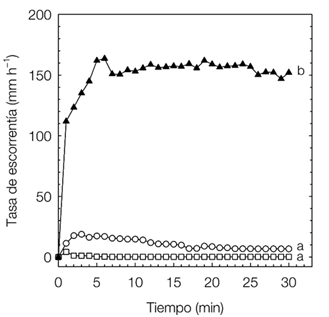
▲= High severity; ○ = Moderate severity, □ = Unburned. Different letters indicate significant differences between curves (P <0.05). n = 10 for each condition.
Figure 3 Hydrograms by post-fire condition.
Average runoff, maximum runoff and total sediment production were higher in plots of high severity compared to moderate severity and unburned areas (P <0.0001) (Table 3). However, the differences in maximum runoff and sediment production were not significant between the plots of moderate severity and in unburned plots (P> 0.05).
Table 3 Runoff and sediment production by post-fire condition.
| Post-fire condition | Av erage runoff (mm h-1) |
Maximum runoff (mm h-1) |
Sediment production (g m-2) |
| Unburned | 0.37 (0.25) a | 4.20 (3.92) a | 0.12 (0.11) a |
| Moderate severity | 10.87 (6.67) a | 22.83 (13.86) a | 0.86 (0.64) a |
| High severity | 152.29 (31.00) b | 199.83 (31.25) b | 10.84 (4.09) b |
Average values are shown (±EE).
Different letters in each column indicate significant differences between post-fire conditions (P < 0.05). n = 10 for each condition.
Influence of the state of the soil surface on runoff and erosion
The soil surface characteristics of the rain simulation plots that most influenced both average runoff and sediment production were the roughness index, slope, rock fragment cover and mulch cover. In general terms, the lower the roughness, the steeper the slope and the lower the coverage of mulch and the greater the coverage of rock fragments; average runoff and sediment production increased (Figures 4a and 4b). The highest average runoff value was reached when the roughness index was less than or equal to 0.344 and the slope greater than 6.88 %, which produces more than 150 mm h-1.

Discussion
Variations in the surface of the soil caused by fires
The effect of the severity of the fires on the runoff and on the sediments production with rainfall simulation was analyzed. Evidence is provided that the impacts of fire on the characteristics of the soil surface and on the runoff and sediment production persist even 3 years after high severity fires occurred in the oak forests studied. In general, it is noted that the mulch coverage and the roughness of the soil surface change depending on the severity of the fire and both are the characteristics of the soil surface that most influence the production of runoff and sediments. However, not all the parameters considered were different among the three post-fire conditions, which highlights the complexity of the interaction between the soil, fire intensity, vegetation and time since the fire, which leads to different severities that modify the superficial hydrological processes in different magnitude (Robichaud et al., 2016).
Undisturbed forests have low runoff and erosion rates (DeBano, 2000), but once a fire occurs, the soil surface changes. The vegetation and mulch cover is reduced, there is less interception of raindrops and the roughness provided by the cover decreases, which prevents waterlogging and reduces the infiltration capacity and increases soil loss (Miller et al., 2013, Pierson et al., 2013). In this way, the soil cover fulfills the dual function of reducing the impact of raindrops and maintaining the roughness of the surface, which is of great importance to favor infiltration and reduce erosion.
Soil cover is one of the characteristics of the surface mostly modified by fire, and in this study it varied consistently among post-fire conditions. It was lower in burned areas compared to unburned areas, because most herbaceous species disappear even with low severity fires (Lavoie et al., 2010). Plant densities are lower in burned areas even up to two years after the fire in oak forests (Elliott and Vose, 2010). On the other hand, mulch was also lower in the burned areas, and there is evidence that it is reduced immediately after a fire, and it can take between two and three years to recover its pre-fire levels (Davies et al., 2009; Bates et al., 2011), which agrees with the results here shown.
According to the results, the decrease of coverage in the parcels of burned areas leaves the soil unprotected against the kinetic energy of rain drops up to 72.5 %, which impacts the runoff and sediment production even after 31 months after the fire.
One of the main findings in this study was the lower roughness of the soil surface in burned areas compared to unburned areas; the decrease in this variable explained most of the average runoff and sediment production in the rain simulation plots. The results suggest that fire diminishes the roughness and leaves a smoother and more homogeneous surface due to the combustion of organic materials, which agrees with the works of Sankey et al. (2010) and Stoof et al. (2015); this reduction in the roughness reduces the surface resistance and increases the water flow and the consequent erosion. The foregoing highlights the importance of knowing the dynamics of roughness in burned areas in order to improve the prediction of hydrological processes and ground soil conservation measures, which may be focused on increasing the roughness of the surface, for example, through revegetation.
The apparent density and fractions of the soil particles were not different among the three post-fire conditions. These two physical properties of the soil are perhaps those in which fewer changes are reported as a direct consequence of the fire. In general, fractions of soil particles are not affected by fire (Oswald et al., 1999), which can happen, is that after a fire, the removal of the finest particles on very steep slopes in the increase of thicker particles (Mermut et al., 1997; Capulín et al., 2009). On the other hand, there is reference that the apparent density of the soil is maintained with values similar to the pre-fire conditions when fires of low and moderate severity occur (Stoof et al., 2015), which coincides with the results of the present study, although it is possible that after frequent fires of low intensity, the apparent density may increase due to the reduction of the percentage of macro-pores (Boyer and Miller, 1994).
Severity of fires, runoff and sediment production
Runoff and sediment production were greater by more than one order of magnitude in areas with high severity than in areas with moderate severity or unburned areas. To a large extent, changes in the soil caused by fire are associated with the degree of severity with which it occurs (Gimeno, 2000); that is to say, those areas with a greater degree of severity have more drastic changes in the hydrodynamic properties of the soil in comparison with the zones of lower severity.
In this study, runoff and sediment production were different only in the high severity compared to the moderate severity and the unburned condition, which agrees with what Ferreira et al. (2005) and Vega et al. (2005) in Mediterranean scrubs and by Robichaud (2000), Johansen et al. (2001) and Benavides and MacDonald (2005) in temperate climate forests. This may be due to the fact that fires of low or moderate severity do not produce significant changes in the stability of the soil aggregates, however, fires of high severity can modify this property depending on the type of soil and the disaggregation can be a consequence of the destruction of soil organic matter (Mataix et al., 2011).
In areas of high severity, the loss of surface cover leaves the soil with less protection against erosive agents and greater erodibility (Robichaud et al., 2016), and in the case of the actual study, a higher proportion of bare soil was confirmed in the simulation plots of rain, which resulted in greater runoff and erosion, as in the works elaborated by Vieira et al. (2015).
Similar values of runoff and sediment production in the conditions of moderate and unburned severity suggest that runoff may be low even in burned areas. This may be due to the existence of a threshold in terms of coverage, and in this sense, it has been reported in burnt areas that as long as the proportion of bare soil does not exceed 70 %, runoff and erosion are minimal (Johansen et al., 2001). This is in agreement with the results of the present study, in which the plots with a proportion of bare soil less than 63.5 % (conditions of moderate severity and without burning) produced the lowest amounts of runoff and sediment production, in comparison with the plots of high severity, with around 73 % of bare soil (27 % of total coverage).
On the other hand, the regression trees showed that roughness, slope and mulch coverage and rock fragments play an important role in runoff and sediment production. In plots with a high roughness index, greater mulch coverage and lower slope, which correspond to moderate or unburned severity, the lowest sediment runoff and drag is produced. This result confirms that the roughness is related to the amount and type of surface coverage of the soil, both variables decrease when a fire occurs and cause an increase in water flow and sediment transport (Miller et al., 2013).
The effects of fire on the physical, chemical and hydrodynamic properties of soil can persist in short or long periods, depending on the severity of the fire, the conditions of the soil surface and the ability to recovery after the fire (Pardini et al., 2004). In this sense, detailed knowledge of the level of damage and its temporality (severity, time since the fire) is an essential factor to quantify the impact of forest fires and proceed with rehabilitation or restoration actions (De Santis et al., 2009). In this study it was determined that only areas with high severity produce greater runoff and erosion, which can be used as a criterion to prioritize soil and water conservation actions.
It is necessary to point out that both runoff and soil erosion depend on the level of the analysis scale (López et al., 2013) and, the studies that exist on the subject use different scales, devices and variable rainfall intensities (in case of using rain simulators), they do not always include the fire severity level as a covariate, and the measurements are made with diverse post-fire temporalities, which makes direct comparison of the results difficult (Malvar et al., 2011; Vieira et al., 2015). This, coupled with the lack of similar studies in Mexico limits the possibility of comparing the results of this research.
Although rainfall simulation has limitations as a research tool in terms of scale, it allows comparing hydrological and erosion responses in a relative manner between different treatments (fire severity), which gives an overview of the dynamics of the superficial hydrological processes on a local scale, and can serve as a basis for studies at the scale of hillsides or micro-basins. To achieve this, it would be advisable to conduct more rain simulation tests and study the interaction of hydrological responses with variables that influence runoff and erosion such as slope length, spatial variability of soil characteristics and hydrological connectivity.
Conclusions
The fires in the oak forests studied in the Sierra Madre Oriental of San Luis Potosí modify the characteristics of the soil surface, such as plant cover and roughness. These changes, in turn, modify the hydrological response in areas depending on the severity of the fires. In areas with high severity, they drain on average 152.29 mm h-1, in contrast to 10.87 and 0.37 mm h-1 in areas with moderate and low severity, respectively. Sediment production follows a similar pattern, with 10.84 g m-2 in areas of high severity, followed in descending order by 0.86 g m-2 in moderate severity and 0.12 g m-2 in low severity.
The roughness of the soil surface, the slope and mulch cover and rock fragments are the variables with the greatest influence on the amount of runoff and erosion. The lower the roughness, the steeper the slope and the lower the coverage of the mulch and rock fragments, the greater the runoff and sediment production. Practically, these characteristics of the soil surface can be integrated as a variable in models that explain runoff and erosion in hillside and micro-basin scales, while the severity of fires can be used as an indicator to define priority areas for soil restoration and forest ecosystems.
Acknowledgements
This project was funded by the Teacher Improvement Program (Project PROMEP / 103.5 / 13/6575), which also awarded a scholarship to the first author. The authors thank Estefani Ramírez Ramos and Jesús Moreno Ramírez for their support in field work and to the owners of the land, who allowed the realization of this study on their property.
REFERENCES
Alanis M., H., J. Návar and P. A. Domínguez. 2000. The effect of prescribed burning on surface runoff in a pine forest stand of Chihuahua, Mexico. Forest Ecology and Management 137: 199-207. [ Links ]
Bates, J. D., K. W. Davies and R. N. Sharp. 2011. Shrub-steppe early succession following juniper cutting and prescribed fire. Environmental Management 47(3): 468-481. [ Links ]
Benavides S., J. and L. H. MacDonald. 2005. Measurement and prediction of post-fire erosion at the hillslope. International Journal of Wildland Fire 14(4): 457-474. [ Links ]
Boyer, W. D. and J. H. Miller. 1994. Effect of burning and brush treatments and soil physical properties in young longleaf pine stands. Forest Ecology and Management 70(1-3): 311-318. [ Links ]
Capulín G., J., L. Mohedano C. y R. Razo Z. 2009. Cambios en el suelo y vegetación de un bosque de pino afectado por incendio. Terra Latinoamericana 28: 79-87. [ Links ]
Davies, K. W., J. D. Bates and J. J. James. 2009. Microsite and herbaceous vegetation heterogeneity after burning. Oecologia 159(3): 597-606. [ Links ]
De Santis, A., E. Chuvieco and P. J. Vaughan. 2009. Short-term assessment of burn severity using the inversion PRPSPECT and GeoSail models. Remote Sensing of Environment 113(1): 126-136. [ Links ]
DeBano, L. F. 2000. Water repellency in soils: a historical overview. Journal of Hydrology 231-232: 4-32. [ Links ]
Doerr, S. H., R. A. Shakesby, W. H. Blake, C. J. Chafer, G. S. Humphreys and P. J. Wallbrink. 2006. Effects of differing wildfire severities on soil wettability and implications for hydrological response. Journal of Hydrology 319(1-4): 295-311. [ Links ]
Elliott, K. J. and J. M. Vose. 2010. Short-term effects of prescribed fire on mixed oak forests in the southern Appalachians: vegetation response. The Journal of the Torrey Botanical Society 137(1): 49-66. [ Links ]
Ferreira A., J. D., C. O. A. Coelho, A. K. Boulet, G. Leighton-Boyce, J. J. Keizer and C. J. Ritsema. 2005. Influence of burning intensity on water repellency and hydrological processes at forest and shrub sites in Portugal. Australian Journal of Soil Research 43(3):327-336. [ Links ]
García, E. 1973. Modificaciones al sistema de clasificación climática de Köppen. Universidad Nacional Autónoma de México. México, D. F., México. 252 p. [ Links ]
Gimeno, E. 2000. Changes in organic matter, nitrogen, phosphorous and cations in soil as a result of fire and water erosion in a mediterranean landscape. European Journal of Soil Science 51(2): 201-210. [ Links ]
International Society of Soil Science. 1929. Minutes of the first commission meetings, International Congress of Soil Science. Transactions of the First Commission of the International Society of Soil Science 4: 215-220. [ Links ]
Johansen, M. P., T. E. Hakonson and D. D. Breshears. 2001. Post-fire runoff and erosion from rainfall simulation: contrasting forests with shrublands and grasslands. Hydrological Processes 15(15): 2953-2965. [ Links ]
Jordán, A., L. M. Zavala, J. Mataix, A. L. Nava and N. Alanís. 2011. Effect of fire severity on water repellency and aggregate stability on Mexican volcanic soils. Catena 84: 136-147. [ Links ]
Keeley, J. E. 2009. Fire intensity, fire severity and burn severity: a brief review and suggested usage. International Journal of Wildland Fire 18(1): 116-126. [ Links ]
Lavoie, M., G. Starr, M. C. Mack, T. A. Martin and H. L. Gholz. 2010. Effects of a Prescribed Fire on Understory Vegetation, Carbon Pools, and Soil Nutrients in a Longleaf Pine-Slash Pine Forest in Florida. Natural Areas Journal 30(1): 82-94. [ Links ]
López V., M., J. Poesen, A. Navas and L. Gaspar. 2013. Predicting runoff and sediment connectivity and soil erosion by water for different land use scenarios in the Spanish Pre-Pyrenees. Catena 102: 62-73. [ Links ]
Malvar, M. C., S. A. Prats, J. P. Nunes and J. J. Keizer. 2011. Post-fire overland flow generation and inter-rill erosion under simulated rainfall in two eucalypt stands in north-central Portugal. Environmental Research 111(2): 222-236. [ Links ]
Mataix S., J., A. Cerdà, V. Arcenegui, A. Jordán and L. M. Zavala. 2011. Fire effects on soil aggregation: A review. Earth Science Reviews 109(1-2): 44-60. [ Links ]
Mermut, A. R., S. H. Luk, M. Romkens and J. Poesen. 1997. Soil loss by splash and wash during rainfall from two loess soils. Geoderma 75: 203-214. [ Links ]
Miller, R. F., J. C. Chambers, D. A. Pyke, F. B. Pierson and J. C. Williams. 2013. A review of fire effects on vegetation and soils in the Great Basin region: response and site characteristics, Gen. Tech. Rep. RMRS-GTR-308. Department of Agriculture, Forest Service, Rocky Mountain Research Station. Fort Collins, CO, USA. 136 p. [ Links ]
Mohammadshirazi, F., V. K. Brown, J. L. Heitman and R. A. McLaughlin. 2016. Effects of tillage and compost amendment on infiltration in compacted soils. Journal of Soil and Water Conservation 71(6): 443-449. [ Links ]
Odion, D. C. and C. T. Hanson. 2006. Fire severity in conifer forests of the Sierra Nevada, California. Ecosystems 9(7): 1177-1189. [ Links ]
Ogden, C. B., H. M. van Es and R. R. Schindelbeck. 1997. Miniature rain simulator for measurement of infiltration and runoff. Soil Science Society of America Journal 61(4): 1041-1043. [ Links ]
Oswald, B. P., D. Davenport and L. Neuenschwander. 1999. Effects of slash pile burning on the physiscal and chemical soil properties of Vassar soils. Journal of Sustainable Forestry 8: 75-86. [ Links ]
Pardini, G., M. Gispert and G. Dunjó. 2004. Relative influence of wildfire on soil properties and erosion processes in different Mediterranean environments in NE Spain. Science of the Total Environment 328(1-3): 237-246. [ Links ]
Pierson, F. B., C. J. Williams, S. P. Hardegree, P. E. Clark, P. R. Kormos and O. Z. Al-Hamdan. 2013. Hydrologic and erosion responses of sagebrush steppe following juniper encroachment, wildfire, and tree-cutting. Rangeland Ecology and Management 66(3): 274-289. [ Links ]
R Development Core Team. 2015. R: A language and environment for statistical computing. R Foundation for Statistical Computing, Vienna. http://www.R-project.org (2 de febrero de 2015). [ Links ]
Robichaud, P. R. 2000. Fire effects on infiltration rates after prescribed fire in Northern Rocky Mountain forests, USA. Journal of Hydrology 231-232: 220-229. [ Links ]
Robichaud, P. R., J. L. Beyers and D. G. Neary. 2000. Evaluating the efictiveness of postfire rehabilitation treatments, General Technical Report RMRS-GTR-63, USDA Forest Service, Rocky Mountain Research Station. Fort Collins, CO, USA. 85 p. [ Links ]
Robichaud, P. R., J. W. Wagenbrenner, F. B. Pierson, K. E. Spaeth, L. E. Ashmun and C. A. Moffet. 2016. Infiltration and interrill erosion rates after a wildfire in western Montana, USA. Catena 142: 77-88. [ Links ]
Rzedowski, J. 2006. Vegetación de México. Comisión Nacional para el Conocimiento y Uso de la Biodiversidad. México, D. F., México.505 p. [ Links ]
Saleh, A. 1993. Soil roughness measurement: chain method. Journal of Soil and Water Conservation 48(6): 527-529. [ Links ]
Sankey, J. B., J. U. H. Eitel, N. F. Glenn, M. J. Germino and L. A. Vierling. 2010. Quantifying relationships of burning, roughness, and potential dust emission with laser altimetry of soil surfaces at submeter scales. Geomorphology 135(1-2): 181-190. [ Links ]
Santi, L. A., J. Melo Damian, M. Roberto Cherubin, T. Jorge, C. Amado, M. Tonini Eitelwein, A. Luis Vian and W. F. Bejarano Herrera. 2016. Soil physical and hydraulic changes in different yielding zones under no-tillage in Brazil. African Journal of Agricultural Research and Development 11(15): 1326-1335. [ Links ]
Shakesby, R. A. 2011. Post-wildfire soil erosion in the Mediterranean: review and future research directions. Earth Science Reviews 105(3-4): 71-100. [ Links ]
Stoof, C. R., A. J. D. Ferreira, W. Mol, J. Van den Berg, A. De Kort, S. Drooger, E. C. Slingerland, A. U. Mansholt, C. S. S. Ferreira and C. J. Ritsema. 2015. Soil surface changes increase runoff and erosion risk after a low-moderate severity fire. Geoderma 239-240: 58-67. [ Links ]
Turner, M. G. and V. H. Dale. 1998. Comparing large, infrequent disturbances: what have we learned? Ecosystems 1(6): 493-496. [ Links ]
Vega J., A., C. Fernández and T. Fonturbel. 2005. Throughfall, runoff and soil erosion after prescribed burning in gorse shrubland in Galicia (NW Spain). Land Degradation & Development 16(1): 37-51. [ Links ]
Vieira, D. C. S., C. Fernández, J. A. Vega and J. J. Keizer. 2015. Does soil burn severity affect the post-fire runoff and interrill erosion response? A review based on meta-analysis of field rainfall simulation data. Journal of Hydrology 523: 452-464. [ Links ]
Received: October 12, 2017; Accepted: May 16, 2018
 Este es un artículo publicado en acceso abierto bajo una licencia Creative Commons
