


Services on Demand
Journal
Article
 text in
  English (pdf)
 Article in xml format
 Article references
 Send this article by e-mail
Indicators
-
 Cited by SciELO
 -
 Access statistics
Related links
-
 Similars in
SciELO
Similars in
SciELO
Share

 Permalink
Revista mexicana de ciencias forestales
Print version ISSN 2007-1132
Rev. mex. de cienc. forestales vol.9 n.45 México Jan./Feb. 2018
https://doi.org/10.29298/rmcf.v9i45.143
Research note
Urban tree risk: a case study at the Instituto Tecnológico Superior de Venustiano Carranza, Puebla
1Centro Nacional de Investigación Disciplinaria en Conservación y Mejoramiento de Ecosistemas Forestales. INIFAP. México.
2Instituto Tecnológico Superior de Venustiano Carranza. México.
The tree component in urban areas is positioned as a fundamental element of well-being in the landscape and of the citizens. Determining the risk for possible damage caused by urban tree-planting is a complex task that combines several purposes. The work focused on inventorying urban trees and establishing indicators of risk aversion, as well as suggesting forestry practices that minimize the likelihood of a disaster in the urban area. An inventory of trees was carried out at the Instituto Tecnológico Superior de Venustiano Carranza (Venustiano Carranza High Technological Institute) (ITSVC) and surveys were carried out on personnel from the same institution. The geographic data of the trees were imported into a GIS program to classify the level of risk. A descriptive statistic and a Principal Component Analysis (PCA) were used to define risk perception. 143 individuals of 12 tree species were recorded. We found an index of 0.30 trees inhabitant-1. Fear of falling individuals or branches that can cause damage to facilities or passers-by is explained with 38.94 % of the total variance in the data. The preventive measure against disasters caused by trees is the relocation of individuals. It was determined that as more information is available on the consequences of natural disasters, the perception of risk is less. The proposed methodology can be applied in larger areas.
Key words: Principal Component Analysis; urban trees; green areas; inventory; risk; GIS
El componente arbóreo en las zonas urbanas se posiciona como elemento fundamental de bienestar de los ciudadanos y del paisaje. Determinar el riesgo por posibles daños causados por el arbolado urbano es una tarea compleja que aborda varios aspectos. El trabajo que se describe a continuación consistió en inventariar los árboles urbanos y establecer indicadores de aversión al riesgo, así como sugerir prácticas silviculturales que minimicen la probabilidad de un desastre en la zona urbana. Se realizó un inventario del arbolado en el Instituto Tecnológico Superior de Venustiano Carranza (ITSVC) y se aplicaron encuestas al personal de dicha institución; los datos geográficos de los individuos muestreados se importaron a un programa de Sistemas de Información Geográfica para clasificar el nivel de riesgo. Para definir la percepción del riesgo se empleó estadística descriptiva y un Análisis de Componentes Principales (ACP). Se registraron 143 individuos de 12 especies. Se calculó un índice de 0.30 árboles habitante-1. El miedo a la caída de ramas o árboles completos que pueda ocasionar daños a las instalaciones o transeúntes se explica con 38.94 % de la varianza total en los datos. La medida preventiva ante desastres ocasionadas por este factor es la reubicación de los ejemplares. Se determinó que, a medida que se tiene más información sobre las consecuencias de los desastres naturales, la percepción del riesgo es menor. La metodología propuesta puede extrapolarse a comunidades más extensas.
Palabras clave: Análisis de Componentes Principales; arbolado urbano; áreas verdes; inventario; riesgo; SIG
The perception of risk for possible damage caused by the trees of green areas in urban areas is a little recurrent subject of research (Matheny and Clark, 2009, Pokorny, 2003). Sometimes trees have their own structural defects (in roots, trunk or branches) or due to lack of maintenance, which causes them to weaken and cause problems to the population that can be fatal. In this condition, they acquire the quality of dangerous or at-risk specimens (O'Brien et al., 1992; Chacalo et al., 1997).
Most urban tree studies focus on services (benefits) and costs (mainly maintenance) (Jim and Chem, 2009; Escobedo et al., 2011; Delshammar et al., 2015; Nowak et al., 1997). However, Koeser et al. (2016) mention that the creation of indicators that help measure the perception of risk can be a mechanism for the prevention of natural disasters. Beck (2006) postulates that the risk is specific to each society in a given space and time, and that it is always latent; he makes a distinction between ecological risk and financial risk. It establishes that there is social aversion to ecological risk and financial risk is conceptualized as a secondary effect, and is classified as a disaster when an event implies monetary losses. On the other hand, Slovic et al. (1982) and García (2005) recognize that the greater the ignorance of the natural disaster, the lower the aversion to risk.
At present, urban expansion is evident due to the growing population increase. In this context, the arboreal component is positioned as a fundamental element of welfare in the urban landscape and environment (Sánchez and Rodríguez, 2014). Urban trees are considered an important element in the city, because they provide ecological elements of economic and social importance such as pollution control, wind barriers, noise deadening microclimate formation, water infiltration to groundwater, the production of oxygen, the reduction of soil erosion, shelter and food for wildlife, the capture of carbon dioxide, the promotion of tourism and cultural support, and the increase in the value of property, for example (Alanís, 2005; Jim and Chen, 2009; Peterson and Straka, 2011; Urbano, 2013; Peckham et al., 2013; Pimienta et al., 2014).
Because of its geographical location (parks, avenues, squares, sports and university areas, etc.), trees can cause damage to streets, avenues and ridges due to their constant competition with urban development (Tovar, 2006; Benavides et al., 2012), so that the risk is greater as there are more trees, since the probability of falling branches or complete trees is maximized. As a result, roads are obstructed and urban infrastructure is damaged; profuse trees generate insecurity to the people. To this situation should be added the problem of the displacement faced by native species from the introduction of new species (Escobedo et al., 2011; Dobbs et al., 2014).
Therefore, an urban tree management is crucial (Otaya et al., 2006) to propose corrective measures through forestry practices in areas with high density, such as pruning and thinning; to avoid future damage to the city, it is necessary to select suitable spaces for the location and relocation of trees or urban forests, for which the Geographic Information Systems (GIS) act as a highly efficient tool (Van Elegem et al., 2002).
The growth of human concentrations has increased the interest to study and manage sustainably the trees of the cities in and around. In view of this panorama, its management through GIS has shown satisfactory results to digitize the mensuration characteristics, obtain inventories and generate spatial information for decision-making in the urban area as a tool for the creation of contingency plans to preserve and improve green areas (Pauleit and Duhme, 2000, Rivas, 2000, Otaya et al., 2006, Martínez e Islas, 2008, Yépez and Lozano, 2014).
In Mexico, research has been conducted with successful results that use GIS in the characterization and management of urban trees; such is the case of Alanís (2005) in the city of Monterrey; López (2008) in Mérida, Yucatán; Benavides et al. (2012) and Velasco et al. (2013) in Mexico City. The issue of the benefits and costs of the creation, adoption and maintenance of green areas has been recurrent in the last 20 years in Mexico (Chacalo and Turpin, 1997; Nowak et al., 1997; Chacalo, 2012; Galindo and Victoria, 2012). However, little has been addressed about society's perception of risk for possible damage caused by urban trees; the related studies focus on evaluating the elements of the trees that imply a risk for the population. Based on the foregoing, the objectives of this work consisted in developing an inventory of urban trees and establishing indicators of risk aversion, through the use of multivariate statistics and Geographic Information Systems; as well as suggest silvicultural practices that minimize the probability of a disaster in the urban area of the Higher Technological Institute of Venustiano Carranza (ITSVC), in the north of Puebla.
Study area
The Venustiano Carranza municipality is located in the Sierra Norte region of Puebla, in the state with the same name, between the parallels 20°24' and 20°36' north, the meridians 97°32 'and 97°50' west (Figure 1), at altitudes between 80 and 500 m (Inegi, 2009). It limits to the North with Pantepec and Francisco Z. Mena municipalities and the state of Veracruz; to the East and South with the aforementioned entity; and in this direction with Jalpan municipality; to the West with the latter and with Pantepec (Inegi, 2009). There are two prevailing climates: in the high parts it is warm humid, with abundant rains in summer and, in the low parts, warm subhumid with rains in summer. The prevailing temperature is 24 to 26 °C, and rainfall varies, in the high areas of 1 500 to 2 000 mm and in the low 1 200 to 1 500 mm. The types of soil present are: Regosol (40 %), Phaeozem (28 %), Vertisol (13 %), Nitosol (12 %) and Leptosol (5 %). In relation to the use of soil and vegetation, agriculture, the urban area, the grassland and the high evergreen forest are present (Inegi, 2009; Inegi, 2015).

Socioeconomic description of the study area
There is a total population of 29 090 people in the municipality, 47.6 % are men and 52.4 % are women. In the cities live 18 516 people and in the rural area, 9 374. According to the social indicator that measures poverty, the following data are available: in a situation of total poverty are 20 880 inhabitants; in extreme poverty: 6 640 and in moderate poverty 14 240. The municipality provides 61.08 % of the water service, 90.07 % of drainage and 97.46 % of electricity (Ceiegep, 2017).
The value of agricultural production in the municipality is 113.25 million pesos, which represents 0.87 % of that of the state of Puebla and the production of fresh meat is 39.7569 million pesos, equivalent to 0.32 % with respect to the state (Ceiegep, 2017).
The population with paid employment is 2 966 inhabitants, of which 1 518 are men and 1 448 women. Of these, the secondary sector occupies 546 and the tertiary sector 2 420 people. Regarding the educational level, according to the Department of Public Education in 2010 in preschool municipal coverage was 3.70 %, primary 2.19 %, secondary 5.13 %, high school 0.00 % and professional studies 8.10 % (Ceiegep, 2017).
Instituto Tecnológico Superior Venustiano Carranza
The Instituto Tecnológico Superior Venustiano Carranza is a higher education institution located in Venustiano Carranza municipality, Puebla State; it is located at the geographic coordinates of 20°28'19.46" north and 97°41'56.77" west, 130 masl; the type of dominant vegetation is the tropical high rain forest (Inegi, 2017).
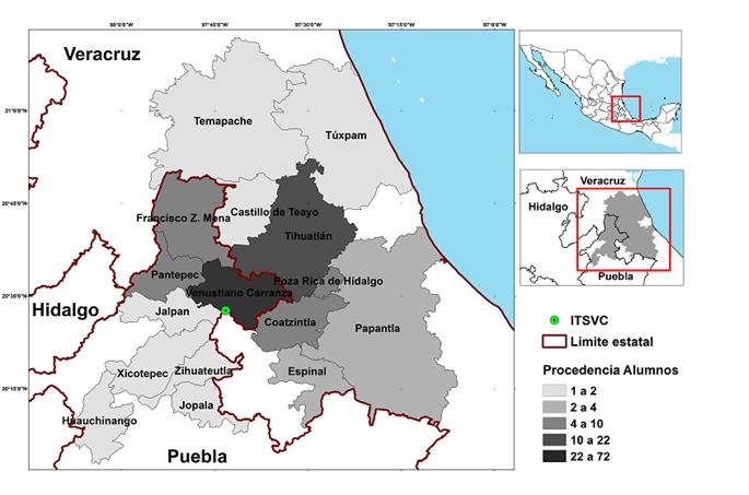
The ITSVC has a concurrence of 477 people on average, among students of engineering careers (Forestry, Geosciences, Food Industries, Computational Systems and Business Management), teaching and administrative staff. There is a high diversity in cultural, religious and economic aspects, accentuated mainly by the origin of municipalities of two states, Puebla: Venustiano Carranza, Pantepec, Jalpan, Xicotepec, Zihuateutla, Jopala and Huauchinango; and Veracruz: Tihuatlán, Francisco Z. Mena, Coatzintla, Poza Rica, Espinal, Papantla, Tuxpan, Temapache and Castillo de Teayo (Figure 2).
Description of the urban trees in the ITSVC
The description of the urban trees was based in the method proposed by Benavides et al. (2012); thus, in October 2016 an inventory was made in which the data of species, normal diameter (D), total height (H) y and the geographic position of each sampled tree were taken. To each individual tree was assigned a consecutive number to keep an ordered record, and were digitized in the QGIS 2.18.11 (QGISDT, 2017). With the heatmap tool, a cartographic map of the tree density was made, which allowed a definition of the density levels (high, medium, low and null). The method proposed by Otaya et al. (2006) Escobedo et al. (2011) and to classify the risk level and to adopt optimal measures of prevention and amendment were used.
Perception of risk by urban trees in the ITSVC
The sample was distributed among the five professional careers present at the institution After the survey was completed, in February and March 2017, the survey was applied to 206 students with a total enrollment of 408: 55 for Forest Engineering (IFOR), 64 to Geosciences (IGEO), 40 to Food Industries (IIAL), 33 to Computational Systems (ISIC) and 14 to Business Management (IGE). In addition, 30 interviews were conducted with teachers (15), administrative (11), security guards (2) and supervisors (2). The survey included information on age, schooling, sex, risk aversion using a Likert scale (very high, high, medium, low and very low) and activities to be implemented in the ITSVC to minimize the possible damage caused by trees in the face of natural and anthropic disasters. The information gathered was complemented by talks with experts in the field.
Once the urban trees were described, the aversion to the risk that the individuals under study perceive was determined, with the assumption that, in areas close to the facilities to the ITSVC and those of the most concurrent routes, the highest tree density is spatially distributed. Therefore, descriptive statistics and a Principal Components Analysis (PCA) were used to define the perception of risk. For a better representation of the results, the Eigenvalues of Component 1 and 2 were averaged, by engineering.
Characterization of urban trees in the ITSVC
The urban tree inventory carried out at the ITSVC facilities registered a total of 143 individuals distributed among 12 species: six native species [Guazuma ulmifolia Lam., Parkinsonia aculeata L., Quercus rugosa Née, Salix humboldtiana Willd., Spondias mombin L. and Tabebuia rosea (Bertol.) DC.] and six introduced [Acacia mangium Willd., Cecropia obtusifolia Bertol., Delonix regia (Bojer ex Hook.) Raf., Eucalyptus globulus Labill, Ficus benjamina L. and Gmelina arborea Roxb.]. The native species represent 15 % of the total population, of which P. aculeata and S. humboldtiana are the highest density (seven each) and the introduced ones make up the rest (85 %); of this group, G. arborea excels (79 individuals). The introduced species are those that occupy the most extensive distribution surface; given this scenario, there is the possibility that the introduction of these species does not meet the criteria defined by Van Elegem et al. (2002), since they consider it necessary for the establishment of this type of trees, to previously carry out a multicriteria analysis (exclusion of areas with restrictions, identification of appropriate areas and selection of feasible spaces) to locate urban forests in the best spaces.
The highest density of trees (52 %) is located in the busiest places in the institution: the main road (25 %), the parking lot (19 %) and the cafeteria (8 %) (Figure 3). This result is attributed to a poor selection of the site where the trees were located; therefore, it is possible that, in the future, these areas of concurrence by the users will present a higher probability of risk of felling or complete fall of the trees due to natural or anthropic events. Given this possible scenario, Otaya et al. (2006) and Escobedo et al. (2011) propose a classification to define the level of risk and adopt preventive and / or corrective measures through a contingency plan whose objective is to mitigate the possible adverse effects derived from a natural or anthropic disaster. In Table 1, the risk classification of trees in the Institution under study is described.

Densidad = Density; Alta = High; Media = Medium; Baja = Low; Nula = Null; Edificio 1 = Building 1; Edificio 2 = Building 2; Planta alimentaria = Food plant; Corredor = Main road; Plaza cívica = Civic square; Cafetería = Cafeteria; >Bodega = Storehouse; Especie = Species; Cercado = Fence; Construcción = Building
Figure 3 Density of the trees in the ITSVC obtained by the heatmap technique of GIS
Table 1 Classification of risk of the trees in the ITSV, according to their physiology and location.
| Risk | Description | Corrective measures | |
|---|---|---|---|
| Pruning | Removal | ||
| High (52 %) | Trees in a radius lower than 10 m from the building zones or busy areas | No | Yes |
| Medium (36 %) | Trees in a 10 to 20 m radius from the building zones or busy areas | Yes (30 % branch) | No |
| Low (12 %) | Trees in distant sites from buildings or busy areas | Yes (60 % branch) | No |
It is worth mentioning that this plan is important and should be timely, since in a hot climate with strong solar radiation, it is essential to consider the environmental services offered by the trees in the crowded places within the urban area, since the trees provide beneficial effects in intercepting excessive solar radiation, and high temperatures decrease with the absorption of heat by vegetation (Sorensen et al., 1998, Lizana, 2003).
In his studies on the ecological footprint in urban areas, Cano (2009) recommends based on the World Health Organization that, in order to obtain a high degree of citizen welfare, at least 1 tree for every 3 people must coexist in the territory (0.33 trees habitants -1); this criterion is not met by the ITSVC areas, where an index of 0.30 trees inhabitants-1 was found. Given this deficit in the green area per inhabitant ratio, it is necessary to increase tree density in areas that represent a low level of risk for the population. Programs of urban reforestation of trees and shrubs should be implemented with a planning of selection of suitable species; locate optimal sites to house arboreal life, maintenance and care of the species. Urban trees are an essential element for individual and spiritual well-being that respond to rights and duties for the whole society to enjoy environmental services (Roy et al., 2012; Peckham et al., 2013).
In addition to the physical and psychological benefits provided to the population by the trees of the cities, they are also reflected in the ecological field by their contribution in reducing wind and noise pollution, in the regulation of thermal balance and in the absorption of water and of atmospheric carbon. In addition, trees provide wildlife habitat, they retain and filter rainwater, they improve air quality, among other functions. Those of the socioeconomic order refer to the improvement of the urban landscape, to the added value to the property, the environmental education and the tranquility that they propitiate with their shade and protection.
Therefore, it is important to carry out an adequate planning of the space, the soil, the management of species, the maintenance and the health of the urban trees. In this way, risk problems for the human population are avoided, and maintenance costs and exposure to natural disasters are reduced (García and Pérez, 2009).
Perception of risk- by- urban- trees in the ITSVC
From the Principal Components Analysis (PCA) it was found that the first component (Prin1) groups variables on the fear of the fall of branches or complete individuals that could cause damage to facilities or passers-by; it explained 38.94 % of the total variance in the data. The second component (Prin2) contemplates variables on the economic consequences (affectations to real estate and properties that generate repair costs) and social consequences (affectations to people), that produce natural disasters and contributes 27.60 % of the total covariance; between them they explain 66.54 % of the total variance of the data (Figure 4). These data agree with what Slovic et al. (1982) and Beck (2006), with the understanding that as there is more information about the consequences of natural disasters, the perception of risk is lower; this may be the reason why in the ITSVC, the population of industrial profile engineering such as Business Management (IGEM) and Computational Systems (ISIC) register the highest levels of risk perception. On the other hand, engineering whose vocation is environmental, such as Forestry (IFOR) and Geosciences (IGEO), there is greater risk aversion.

Engineering professional careers: Forest (IFOR); Geosciences (IGEO); Food Industries (IIAL); Computational Systems (ISIC); Business management (IGE).
Figure 4 PCA to determine the aversion to risk by urban trees in the ITSVC according to the degree of knowledge of the damage caused by natural disasters.
Although the perception of risk for possible damage caused by trees in the ITSVC varies depending on the profiles followed by the different engineering firms in the Institute, an environmental sentiment prevails in most of the population that prefers the relocation of the facilities to prevent disasters (75 %) before the felling of trees (15.28 %) (Table 2). This feeling, according to Urbano (2013), is recurrent in contemporary societies due to the amount of information and dissemination that has developed around concepts such as climate change, sustainability and environmental conservation.
Table 2 Preventive measures in the face of possible disaster produced by the trees in the ITSVC.
| Engineer | Suggested preventive measures before possible natural disasters | ||
|---|---|---|---|
| Facility relocation | Tree felling | Others | |
| IFOR | 76.36 | 10.91 | 12.73 |
| IGEM | 78.57 | 21.43 | 00.00 |
| IGEO | 67.19 | 17.19 | 15.63 |
| IIAL | 82.50 | 15.00 | 02.50 |
| ISIC | 78.79 | 12.12 | 09.09 |
| Total | 75.00 | 15.28 | 09.72 |
Professional careers in engineering: IFOR = Forest; IGEO = Geosciences; IIAL = Food Industries; ISIC = Computational Systems; IGEM = Business management; 1 = It includes details about tree forestry management (pruning and clearing).
The inventory of the trees of the Higher Technological Institute of Venustiano Carranza served to analyze the spatiality and distribution of the trees, which are crucial to generate recommendations against the risk aversion of the study center community.
The indicators used in this study were useful instruments for estimating the risk perception of the Institute's population, which generated proposals for corrective measures for the prevention of natural disasters.
The use of statistical tools and geographic information systems allows the creation of solid spatial indicators. These tools are useful for decision makers, since they allow the optimization of an urban tree management plan by programming activities that minimize risk scenarios in urban areas.
The education and information held by the Institute's community have favored the positive opinion of the importance of preserving green areas. However, the perception of risk due to fall or road affectations that can cause some meteorological phenomenon of great intensity or due to advanced age of the trees still varies; although in general, the perception of risk is lower.
The attention to the areas with greater vulnerability for the population and the rearrangement of species in incorrect sites were the best suggested practices.
Acknowledgements
The authors wish to express their gratitude to the ITSV authorities for having let the execution of the Project entitled: Percepción del riesgo por el arbolado urbano ante desastres naturales: estudio de caso en el Instituto Tecnológico Superior de Venustiano Carranza, Puebla.
REFERENCES
Alanís F., G. J. 2005. El arbolado urbano en el área metropolitana de Monterrey. Ciencia UANL 8(1): 20-32. [ Links ]
Beck, U. 2006. Living in the world risk society. Economy and society 35(3): 329-345. [ Links ]
Benavides M., H. M. y D. Y. Fernández G. 2012. Estructura del arbolado y caracterización dasométrica de la segunda sección del Bosque de Chapultepec. Madera y Bosques 18(2):51-71. [ Links ]
Chacalo, A., J. Grabinski and A. Aldama. 1997. Site limitations for tree growth in Mexico City. Proceedings METR1A. Ohio State University. http://www.ohiostate.edu/METRIA/Metria9.html (20 de septiembre de 2017). [ Links ]
Chacalo H., A. y S. Turpin. 1997. Beneficios de los árboles en la ciudad. In: Chacalo H., A.(ed.). Manejo del arbolado urbano. UNAM. México, D. F., México. pp. 25-33. [ Links ]
Chacalo H., A. 2012. El cuidado de los árboles en ambientes urbanos. Propuestas para la Gestión de los Parques en México Propuestas para la Gestión de los Parques en México http://www.organicaeditores.mx/biblioteca/parques2012/contenido/0_ContDesc_Chacalo.pdf (20 de septiembre de 2017). [ Links ]
Cano O., A. 2009. Territorio y sostenibilidad. Aproximación a la huella ecológica de Andalucía. Revista de Estudios Regionales 84:115-145. [ Links ]
Comité Estatal de Información Estadística y Geográfica del Estado de Puebla (CEIEGEP). 2017. Información Básica del Municipio: Venustiano Carranza. Fichas municipales. http://www.coteigep.puebla.gob.mx/est231.php?muni=21194 (13 de agosto de 2017). [ Links ]
Delshammar, T., J. Östberg. and C. Öxell. 2015. Urban trees and ecosystem disservices-a pilot study using complaints records from three Swedish cities. Arboriculture and Urban Forestry 41(4):187-193. [ Links ]
Dobbs, C., D. Kendal and C. R. Nitschke. 2014. Multiple ecosystem services and disservices of the urban forest establishing their connections with landscape structure and sociodemographics. Ecological Indicators 43: 44-45. [ Links ]
Escobedo, F. J., T. Kroeger and J. E. Wagner. 2011. Urban forests and pollution mitigation: analyzing ecosystem services and disservices. Environmental Pollution 159(8-9): 2078-2087. [ Links ]
Galindo B., A. S. y R. Victoria U. 2012. La vegetación como parte de la sustentabilidad urbana: beneficios, problemáticas y soluciones, para el Valle de Toluca. Quivera 14(1): 98-108. [ Links ]
García A., V. 2005. El riesgo como construcción social y la construcción social de riesgos. Desacatos, Revista de Ciencias Sociales 19: 11-24. [ Links ]
García., N. y T. Pérez. 2009. El verde urbano: indicador de sostenibilidad. Su incidencia en la calidad de vida del sancristobalense. In: 7th Latin American and Caribbean Conference for Engineering and Technology (LACCEI’ 2009). Energy and Technology for the Americas: Education, Innovation, Technology and Practice. June 2-5. San Cristobal, Venezuela. pp. 1-11. [ Links ]
Instituto Nacional de Estadística y Geografía (Inegi). 2009. Prontuario de información geográfica municipal de los Estados Unidos Mexicanos. http://www3.inegi.org.mx/contenidos/app/mexicocifras/datos_geograficos/21/21194.pdf (1 de agosto de 2017). [ Links ]
Instituto Nacional de Estadística y Geografía (Inegi). 2015. Anuario estadístico y geográfico de Puebla. INEGI. Aguascalientes, Ags., México. 827 p. [ Links ]
Instituto Nacional de Estadística y Geografía (Inegi). 2017. Espacio y datos de México. http://www.beta.inegi.org.mx/app/mapa/espacioydatos/ (15 julio de 2017). [ Links ]
Jim, C. Y. y W. Y. Chen. 2009. Ecosystem services and valuation of urban forests in China. Cities 26(4): 187-194. [ Links ]
Koeser, A. K., R. J. Hauer, J. W. Miesbauer and W. Peterson. 2016. Municipal tree risk assessment in the United States: Findings from a comprehensive survey of urban forest management. Arboricultural Journal 38(4):218-229. [ Links ]
Lizana, C. 2003. Programa de arborización urbana para la Región Metropolitana de Santiago. Revista Urbano 6(8):15-21. [ Links ]
López F., I. S. 2008. Arbolado urbano en Mérida, Yucatán y su relación con aspectos socioeconómicos, culturales y de la estructura urbana de la ciudad. Tesis de Maestría. Centro de Investigación y de Estudios Avanzados del Instituto Politécnico Nacional, Unidad Mérida, Departamento de Ecología Humana. Mérida, Yuc., México. 161 p. [ Links ]
Martínez T., T. y L. Islas R. 2008. Aplicación de los sistemas de información geográfica en el manejo del arbolado urbano. Revista Arbolama 1(1):16-25. [ Links ]
Matheny, N. and J. Clark. 2009. Tree risk assessment. Arborist News 19(1):28-33. [ Links ]
Nowak, D. J., J. F. Dwyer y G. Childs. 1997. Los beneficios y costos del enverdecimiento urbano. In: Krishnamurthy, L. y J. Rente N. (eds.). Áreas verdes urbanas en Latinoamérica y el Caribe. Banco Interamericano de Desarrollo. Universidad Autónoma Chapingo. Texcoco, Edo. de Méx., México. pp. 18 -38. [ Links ]
O’Brien, J. G., P. J. Bedker and M. E. Mielke. 1992. Urban tree risk management: a community guide to program design and implementation. U.S. Department of Agriculture. NE Area. St Paul, MN, USA. 247 p. [ Links ]
Otaya B., L. A., R. J. Sánchez Z., L. Morales S. y V. Botero F. 2006. Los sistemas de información geográfica (SIG), una gran herramienta para la silvicultura urbana. Revista Facultada Nacional de Agronomía 59(1): 3201-3216. [ Links ]
Pauleit, S. and F. Duhme. 2000. GIS assessment of Munich’s urban forest structure for urban planning. Journal of Arboriculture 26(3):133-141. [ Links ]
Peckham, S. C., P. N. Duinker and C. Ordóñez. 2013. Urban forest values in Canada: Views of citizens in Calgary and Halifax. Urban Forestry and Urban Greening 12:154-162. [ Links ]
Peterson, K. S. and T. J. Straka. 2011. Specialized discounted cash flow analysis formulas for valuation of benefits and costs of urban trees and forests. Arboriculture and Urban Forestry 37(5):200-206. [ Links ]
Pimienta B., E., C. Robles M., S. Carvajal, A. Muñoz U., C. Martínez Ch. y S. de León S. 2014. Servicios ambientales de la vegetación en ecosistemas urbanos en el contexto del cambio climático. Revista Mexicana de Ciencias Forestales 5(22):28-39. [ Links ]
Pokorny, J. D. 2003. Urban tree risk management: A community guide to program design and implementation. USDA Forest Service, Northeastern Area, State and Private Forestry NA-TP-03-03. Saint Paul, MN, USA. 194 p. [ Links ]
Quantum GIS Development Team (QGISDT). 2017. Quantum GIS Geographic Information System. Open Source Geospatial Foundation Project. http://qgis.osgeo.org (10 de junio de 2017). [ Links ]
Rivas T., D. 2000. ÁrbolSig: Sistema de Información Geográfica para Árboles Urbanos. Colombia. Universidad Distrital “Francisco José de Caldas”, Facultad de Ingeniería, Especialización en Sistemas de Información Geográfica. Santa Fe de Bogotá, DC, Colombia. 52 p. [ Links ]
Roy, S., J. Byrne and C. Pickering. 2012. A systematic quantitative review of urban tree benefits, costs, and assessment methods across cities in different climatic zones. Urban Forestry and Urban Greening 11(4): 351-363. [ Links ]
Sánchez Á., O. J. y L. A. Rodríguez P. 2014. Valoración del arbolado en la Universidad Distrital Francisco José́ de Caldas (Famarena) con tecnología field-map. Boletín Semillas Ambientales 8(2): 13-18. [ Links ]
Slovic, P., B. Fischhoff and S. Lichtenstein. 1982. Why study risk perception? Risk analysis, an International Journal 2(2): 83-93. [ Links ]
Sorensen, M., V. Barzetti, K. Keipi y J. Williams. 1998. Manejo de áreas verdes urbanas. Documento de buenas prácticas. Banco Interamericano de Desarrollo. Washington, DC, USA. pp. 19-32. [ Links ]
Tovar C., G. 2006. Manejo del arbolado urbano en Bogotá. Colombia Forestal 9(19): 187-205. [ Links ]
Urbano L. de M., B. 2013. Naturación urbana, un desafío a la urbanización. Revista Chapingo. Serie Ciencias Forestales y del Ambiente 19(2): 225-235. [ Links ]
Van Elegem, B., T. Embo, B. Muys and N. Lust. 2002. A methodology to select the best locations for new urban forest using multicriteria analysis. Forestry 75(1): 13-23. [ Links ]
Velasco B., E., E. N. Cortés B., A. González H., F. Moreno S. y H. M. Benavides M. 2013. Diagnóstico y caracterización del arbolado del bosque de San Juan de Aragón. Revista Mexicana de Ciencias Forestales 4(19): 102-111. [ Links ]
Yépez R., F. D. y D. F. Lozano G. 2014. Mapeo del arbolado urbano con lidar aéreo. Revista Mexicana de Ciencias Forestales 5(26): 58-74. [ Links ]
Received: August 14, 2017; Accepted: December 04, 2017
 Este es un artículo publicado en acceso abierto bajo una licencia Creative Commons
