


Servicios Personalizados
Revista
Articulo
 texto en
  Inglés (pdf)
 Artículo en XML
 Referencias del artículo
 Enviar artículo por email
Indicadores
-
 Citado por SciELO
 -
 Accesos
Links relacionados
-
 Similares en
SciELO
Similares en
SciELO
Compartir

 Permalink
Revista mexicana de ciencias forestales
versión impresa ISSN 2007-1132
Rev. mex. de cienc. forestales vol.8 no.43 México sep./oct. 2017
Research note
Hydrological behavior of a small rangeland and forest watershed in southeastern Coahuila
1Campo Experimental Saltillo, CIR Noreste. INIFAP. México.
2Centro Nacional de Investigación Disciplinaria en Relación Agua-Suelo-Planta-Atmósfera. INIFAP. México.
3Campo Experimental Zacatecas. CIR Norte-Centro. INIFAP. México.
The deterioration of the ecosystem forest puts rain water storage and flow at risk. The State of Coahuila comprises 450 000 hectares of forests that serve as a rainwater catchment area. Continuous monitoring of the hydrological variables of the watershed is essential for make a better use of this resource, particularly where there is climatic uncertainty. The objective of this study was to document the hydrological behavior of a small experimental forest and rangeland watershed by monitoring the variables and through the use of a hydrological model with spatially semi-distributed parameters of the Experimental Watershed of INIFAP in Saltillo, Coahuila. The hydrological response of the watershed was analyzed based on the historical precipitation records quantified for 2016. The WIN TR-55 model was used to explain the absence of runoff in terms of the semi-distributed parameters of the watershed. The precipitation data for 2016 showed that source areas of surface runoff are the mountainsides, and that the bottom (the valley) acts as a buffer area that restricts its flow towards the runoff gauging station. According to the model simulations, a daily precipitation of over 65 mm is required in order to record surface flow at the runoff gauging station.
Key words Source area; curve number; surface runoff; WIN TR - 55 model; rainfall monitoring; hydrological process
El deterioro de los ecosistemas forestales pone en riesgo el almacenamiento y flujo del agua de lluvia. En el estado de Coahuila, existen 450 mil hectáreas de superficie forestal, las cuales son un área de captación de agua de lluvia. Para lograr un mayor aprovechamiento de este recurso es indispensable el monitoreo continuo de variables hidrológicas en las cuencas, principalmente, donde existe incertidumbre climática. El objetivo del presente estudio fue documentar el comportamiento hidrológico de una pequeña cuenca de uso ganadero-forestal, a partir del monitoreo de variables y el empleo de un modelo hidrológico de parámetros semidistribuidos espacialmente de la Cuenca Experimental del INIFAP, ubicada en el municipio Saltillo, Coah. Con registros históricos, cuantificados durante 2016 de precipitación pluvial se realizó el análisis de la respuesta hidrológica. Se utilizó el modelo WIN TR-55 para explicar la ausencia de escurrimiento, en función de parámetros semidistribuidos. Con los datos pluviométricos de 2016, se observó que las áreas de aportación de flujo superficial son las laderas y que la parte baja de la misma (el valle) actúa como un área buffer que restringe el escurrimiento superficial hacia la estación de aforo. En función a las simulaciones con el Modelo WIN TR - 55, se requiere una lámina precipitada diaria (máxima en 24 horas) mayor a 65 mm para registrar flujo superficial en la estación de aforo.
Palabras clave: Área fuente; curva numérica; escurrimiento superficial; modelo WIN TR - 55; monitoreo de precipitación; procesos hidrológicos
The forest surface of Mexico is approximately 138 million hectares, i.e. 70.4% of the national territory. 24. 2% of this surface consists of temperate forests (DOF, 2014). Among other benefits, the forest canopy filters the rainwater and regulates the flow of water in the ecosystem. However, the forest resources are continually exposed to agents that cause their deterioration as an ecosystem. Some of the main agents causing this are forest fires (Rodríguez-Trejo and Fulé, 2003), pests and diseases (Sánchez et al., 2003), changes in land use (Torres-Rojo and Flores-Xolocotzi, 2014) and, especially, excessive logging.
The deterioration of the forest ecosystems entails the simultaneous alteration of physical processes, such as runoff generation and leakage, which determine their functioning and their sustainability. For example, the occurrence of a fire may alter the interception, leakage, evapotranspiration and storage of the soil moisture and the flow of water on the land surface (DeBano, 2009).
Hydrological Impacts. The manipulation of the vegetation of forest areas has caused hydrological modifications. Some causes of this are the reduction of the forest canopy and increase in evapotranspiration (Swindel et al., 1983; Cui et al., 2012). Ecological factors such as the amount and structure of the tree canopy reduce water loss and sediment production (Zheng et al., 2008).
On the other hand, according to the records, surface runoffs in forest areas depend partially on the depth of the soil, on their structure and on the degree of saturation before the precipitation (Yu et al., 2015), as well as on the organic mulch on the soil and on the soil’s properties (Zheng et al., 2008).
Another relevant hydrological aspect of forest watersheds that has not been considered in this study is the presence of preferential flow, mainly in those sites where the soil has a high hydraulic conductivity, due to the continuity and density of the macropores caused by the size of the roots of the arboreal species in the soil matrix (Alaoui et al., 2010).
There are specific methods to determine the changes in the tendencies of the hydrological variables due to the management of the vegetation, e.g. the single hydrograph method (Černohous and Kovář, 2009). However, mathematical models are the most commonly used tool for simulating and predicting the hydrological behavior in watersheds (Gholami, 2013; Hlásny et al., 2015). Chen et al. (2013) assessed different types of models (empirical and physically based) for determining the impact of fires on a forest watershed in terms of processes such as evapotranspiration, surface runoff, canal flow, and flow on saturated and unsaturated sub surface areas.
One of the deterministic models used to quantify the hydrological impact on watersheds with different land uses is WIN TR - 55 (USDA-NRCS, 1986), which is empirical and has semi-distributed parameters for watersheds of 6 500 ha or less. The Numerical Curve Method proposed by the SCS (USDA-SCS, 1972) is used to calculate the sheet of runoff; furthermore, this model assumes an antecedent moisture condition II (average moisture condition) and assigns parameters of surface, numeric curve (soil type, hydrological status and land use) by sub-basin, as well as the canal hydraulics (slope, Manning’s coefficient, canal bottom width, slope gradient ratio and type of cover) per precipitation event.
Importance of hydrological monitoring. According to the Inventario Forestal y de Suelos (State Soil and Forest Inventory) (Semarnat-Conafor, 2013), only 4.1% of the vegetation of the surface area of the state of Coahuila (15 067 115 ha) is constituted by conifer, conifer and broadleaf, and broadleaf forests. This surface is a rainwater catchment and storage area. The captured and stored fluid is a source of water supply for residential, recreational and industrial uses. From the point of view of the hydrological balance of forest watersheds, there are no recent references for the state. However, this topic is one of the goals of the Programa Especial de Agua (Special Water Program) 2011-2017 (Gobierno del Estado de Coahuila, 2012), according to which it is important to “ensure knowledge of the hydrological cycle of the entity and to propitiate scientific research for the sustainable use of water”.
Thus, a better use of this resource requires an ongoing monitoring of the hydrological variables, in order to obtain the technical foundations of such physical processes as the generation of surface flow for decision-making in the management of natural resources (Sánchez, 2005; Cui et al., 2012).
The objective of the present study was to document the hydrological behavior of a small rangeland and forest watershed by monitoring the variables and through the use of a mathematical model of semi-distributed parameters that may account for the hydrological behavior of the Cuenca Experimental Saltillo de INIFAP (Saltillo Experimental Watershed, CES, Spanish acronym) of INIFAP, located in the southern region of Saltillo, Coahuila, during the year 2016.
Study area
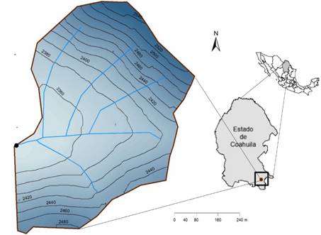
The Saltillo Experimental Watershed (CES) is located in the Bravo-Conchos (RH24Be) hydrological region in Saltillo municipality, at 101°00'30'' West longitude and 25°09'00'' North latitude, and has a surface area of 47.2 hectares (Figure 1). CES is located in the region known as the Zapalinamé sierra, with a surface area of 45 226.8 hectares (Gobierno del Estado de Coahuila, 1998). This micro region has an extensive, varied vegetation, whose prevalent species include pinyon pine and oak forests and xerophytic shrubs.
The climate, according to Köppen’s climate classification, modified by García (1988), is of the BS1kw type -semi-dry temperate-, with temperatures ranging between 11.5 and 25.3 °C, with a mean annual precipitation of 356.7 mm (Díaz et al., 2007). The vegetation is a Pinus cembroides Zucc. (pinyon pine) and Quercus spp (oak) forest associated with a native grassland (Figure 2), and it comprises the following taxa: Larrea tridentata (DC.) Coville (creosote bush), Yucca carnerosana (Trel.) McKelvey (Giant Spanish Dagger), Yucca filifera Chabaud (Chinese palm), Fouquieria splendens Engelm. (slimwood), Juniperus sp (juniper), Agave lechuguilla Torr. (lechuguilla), Opuntia spp (nopal), Dalea bicolor Humb. & Bonpl. ex Willd. (silver prairie clover), Flourencia cernua DC. (American tarwort), Atriplex canescens (Pursh) Nutt. (fourwing saltbush), Agave spp (maguey), Acacia farnesiana (L.) Willd. (huisache), Euphorbia antisyphilitica Zucc. (candelilla), Mimosa biuncifera Benth. (catclaw mimosa), Dasylirion cedrosanum Trel. (sotol), Parthenium argentatum Gray (guayule), Bouteloua gracilis (Kunth) Lag. ex Steud. (blue grama), B. curtipendula (Michx)Torr (sideoats grama), Lycurus phleoides Kunth (wolftail) and Hilaria sp (curly mesquite).
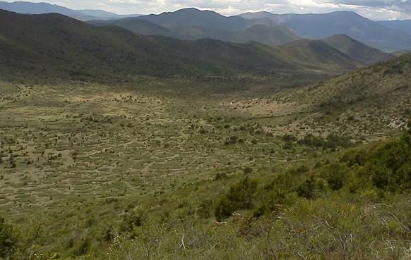
Figure 2 General view of the various vegetation types in the Saltillo Experimental Watershed, Saltillo, Coah.
The mean slope of the land in the watershed is 50.7%, with a mean altitude of 2 450 m; the soil units (FAO-UNESCO, 1990) are calcareous Leptosol and skeletal Phaeozem with medium texture and with fragments of gravel on its surface, and having a medium fertility. The natural resources in the Watershed face problems like a scanty vegetation cover on the mountainsides, the erosion of slopes mountainsides, invasion by species that are undesirable for stockbreeding, and the formation of erosion gullies.
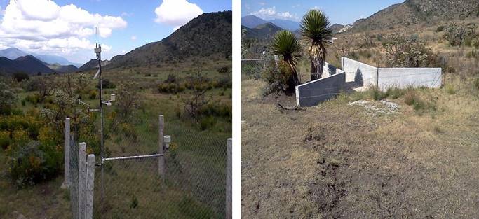
Register of hydrological variables. In order to quantify some of the hydrological variables, various equipments were set up for their temporary monitoring. An ADCON Telemetry automated weather station was installed to monitor the weather. Next to the weather station, a type H gauge canal in which an optic sensor (local, non-patented and labeled) was built to estimate the height of the surface runoff above the bottom of the canal (Figure 3).
Precipitation regime
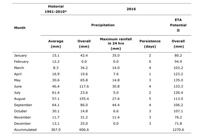
The characterization of the temperature and the rainfall, based on the registers of the weather station located at the Experimental Watershed is shown graphically in Figure 4. The year 2016 was considered “good” in terms of the total annual precipitation sheet (606.6 mm) with respect to the annual average (367.0 mm) registered by the Sistema Meteorológico Nacional (National Weather Service). 151 precipitation events (maximum rainfall in 24 hours) above one millimeter were counted for this year; five of them registered an intensity above 10 millimeters in 15 minutes. Table 1 shows that, with the exception of the months of February, April, July, September and October, the registered monthly precipitation was larger than the mean monthly precipitation from 1951 to 2010. During the rainy season (June through September), July alone received 21% of the historical monthly average.
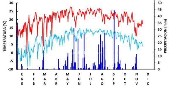
Figure 4 Temperature and precipitation regime at the Experimental Watershed in Saltillo, Coahuila, during 2016.
The measurements registered at the station made it possible to calculate certain statistics of the time series for the year 2016 which are shown in Table 1. As for the persistence of the occurrence or record of the maximum rainfall in 24 hours (continuous days with registered rainfall), the month with the highest persistence of precipitation events was shown to be September, with at least 5 continuous days of rain.
Since the data constitute a very short historical series (one year), no clear relationship was obtained between the precipitation sheet and that registered on the previous five and three days (R2 = 0.17 y 0.39, respectively); however, the trend line is negative, which indicates that the magnitude prior to events with a higher precipitation is very low. Notably, for the two registered events with the highest precipitation (44.4 and 30.8 mm), the amount of rainfall accumulated in the three previous days was 1.4 and 2.0 mm, respectively.
In the face of this type of rainfalls (showers), it is usual to observe the hydrological response of the watersheds in the form of surface runoff. However, when these particular events occur, the soil moisture conditions, the infiltration capacity at those sites of the watershed with least slope and with the largest amount of vegetal cover were not optimal for generating a sufficient sheet flow to be registered by the gauging station.
Based on the Numerical Curve Method developed by USDA-SCS (1972), and in relation to the antecedent moisture condition as a function of rain precipitation, 62.5% of the 80 registered precipitation events of more than one millimiter in 24 hours had an antecedent moisture condition I (the precipitation accumulated during the 5 days prior to the event was 0 to 12.7 mm); 26.3% had a condition II (the precipitation accumulated during the 5 days prior to the event was 12.7 to 38.1 mm), and only 11.2% had an antecedent moisture condition III (the precipitation accumulated during the 5 days prior to the event was > 38.1 mm). In terms of the antecedent moisture, and in general, the condition of the soil in this part of the watershed is dry (CNI).
Surface hydrology
Overall, the hydrological response in forest waterbeds is in terms of the magnitude and duration of storms, among other factors (Ide et al., 2010). As we mentioned before, no direct surface runoff events were registered at the gauging station during 2016. We deduct that the totality of the precipitation that ran down the mountainsides leaked into the bottom of the basin, as neither the magnitude nor the intensity of the precipitation were sufficiently high to surpass the soil infiltration rate in that area (the valley) of the watershed. Although preferential flow is usual in forest watersheds (Alaoui et al., 2010), the prevalent vegetation in the valley of the studied watershed is grasslands and shrubs, whose roots have no significant impact on the formation of macropores in the soil matrix.
Another essential factor related to the absence of surface runoff is the soil moisture content previous to the precipitation event (La Torre et al., 2011). The soil moisture for a particular time is the result of the hydric balance of the site (Bay, 1969). The low persistence of the precipitation events and the evapotranspiration observed during the rainy season (Table 1) indicate that the conditions at the Experimental Watershed during the year 2016 were not favorable to the generation of surface runoff; an evidence of this is that no surface runoff was registered.
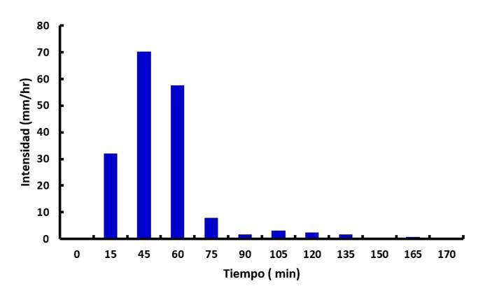
From the point of view of the conservation of the soil and of water, this behavior is ideal; i.e. the watershed has the soil conditions (a sandy texture for an average of 25 sampling sites; the mean sand content was above 33%) and an excellent basal cover (89% of which is constituted by grasses, herbs and organic mulch), to infiltrate a precipitation sheet of 44 mm during two hours and 15 minutes, with a maximum intensity of 70 mm hr-1 (Figure 5). This hydrological behavior MAY minimize the erosive energy provided by the surface runoff on the flat portion of the basin; Hernández et al. (2013) agree, as they point out that erosion gullies are scarce in the grasslands close to the experimental watershed.
Livestock breeders are directly affected by the hydrological response of the Experimental Watershed, since the absence of surface runoffs reduces the possibility of storing water in levees for animal consumption. This leads the producers to seek how to increase the runoff coefficients in order to increase the production of the priced fluid, although this may be detrimental to soil conservation and even to the vegetation present in the watershed.
Hydrological modelling
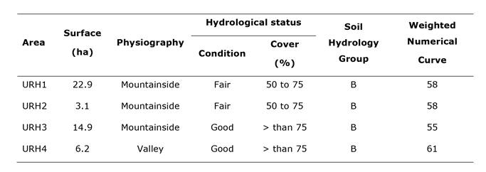
A distributed simulation of the generation of surface runoff in the watershed according to its present conditions with the WIN TR - 55 model was used to explain the hydrological response of the experimental watershed. The watershed was divided into four hydrological response units (HRU) as shown in Figure 6. The conditions of the land in each unit (Table 2) may be differentiated according to the surface, the physiography (mountainside or valley), the hydrological status in terms of the grass cover, and the hydrological group (the ability of the soil and the vegetation to generate surface runoff). Based on these aspects, each area was assigned a value on the numerical curve, according to the manual by USDA-SCS (1972). An element differentiating each HRU was its current vegetation; e.g. although the vegetation of the entire watershed consists of a conifer forest in association with xerophytic shrubs, in the case of HRU 1, most of it is xerophytic shrubs with a degraded soil and an average slope of 33.5%; HRU 2 is represented by conifers and grasses, with the presence of erosion gullies and a slope of 41.9%; HRU 3 is the portion of the watershed with the most dense vegetation cover, mainly Quercus species, on a land with basal cover constituted by organic mulch and fragments of rocks and a slope of 26%, and HRU 4 corresponds to the valley of the watershed, in whose basal stratum xerophytic shrubs and grasses are prevalent, with a slope of 8.9%. Es importante señalar que a excepción de la URH 4, el resto de la superficie constituye un área de captación de agua de lluvia y fuente de escurrimientos superficiales; mientras que, para la producción de sedimentos, toda la superficie de la cuenca tiene la posibilidad de presentar pérdidas de suelo, en mayor grado la URH 2.

Figure 6 Schematic representation of the Homogenous Response Units (HRU) in the Experimental Watershed Saltillo, Coah.
Table 2 Characterization and parameters of the WIN TR - 55 Model for each area of the Experimental Watershed in Saltillo, Coahuila (2016).
The results of the simulations of surface runoff at the Experimental Watershed using the WIN TR - 55 model agree with the records of the gauging station, i.e. even with the heaviest rainfall registered by the weather station at the site in 2016 (44 mm), the model generated no runoff; a similar situation was observed in-field. In order for surface runoff to be registered at the watershed’s outlet, a precipitation sheet of over 65 mm in 24 hours is required (rainfall with a return period of 25 years), according to a publication by the Secretaría de Comunicaciones y Transportes (Department of Communications and Transportation) (1990) (Figure 7).
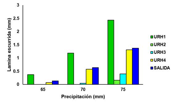
Figure 7 Relationship between the runoff sheet(mm) simulated by the WIN TR - 55 Model at the various HRUs and at the watershed’s outlet, for different magnitudes of precipitation events at the Experimental Watershed in Saltillo, Coahuila.
The simulation of the hydrological behavior of the Experimental Watershed evidences the existence of an area effect on the contribution to the runoff (Figure 7). For this watershed, HRU 1 is the part that most contributes to the occurrence of surface runoff because its surface area is larger, its slope is steeper, its vegetation cover is scanty, and its soil is shallow. The second runoff source area is the portion of the watershed physiographically considered as the valley, and -despite the fact that it has a less steep slope than the other three, and due to its closeness to the gauging station, because it receives the contributions of excess rainfall from the other areas, and when the moisture contents are high, previous to the storm, i.e., to the torrential event-, the valley is regarded as the area that most contributes to the runoff potentially registered at the gauge canal at the watershed’s outlet.
The values of the numerical curve used in this study agree with the interval registered for other forest watersheds (Tedela et al., 2012); however, although the SCS method was not the object of assessment, we should note that, because the utilized values are tabular, research must be carried out in order to more accurately define, through a sensitivity analysis, the value of the numerical curve for those forest watersheds (Tedela et al., 2012) in which different soil types (due to hydric erosion), altitude gradients (land slopes), soil geneses (alluvial soils) exist, as well as for watersheds where mismanagement or fires have affected the type and status of the vegetal succession.
Conclusions
The information generated is preliminary; therefore, the database for the climate, soil and vegetation must be increased. This entails an ongoing monitoring of the hydrological variables at the Experimental Watershed in Saltillo, Coahuila.
The non-existent hydrological response at the watershed in terms of surface runoff during the year 2016 indicates the interaction between the management of the water-soil-plant-animal resources and the climatological characteristics and physical conditions of the said watershed. Within this context, it is important to use such techniques as the chemical tracers in order to determine the movements of the underground water flows and their potential contribution to an increase in water sources for the city of Saltillo.
It is equally important to analyze the variability of the intensity of precipitations in space and time, the infiltration process, the redistribution of the soil moisture by runoff areas, and the dynamics of the vegetation cover of the soil in terms of its management. On the other hand, it is also important to specify the values of the numerical curve and to validate the hydrological information generated by the WIN TR - 55 Model with regard to the generation of runoff from precipitation events of more than 65 mm in forest watersheds.
Acknowledgements
The present work is part of the Fiscal Project of INIFAP: “Monitoring of physical processes at watersheds in marginalized areas with environmental degradation” (Project No. SIGI: 1050332913). The authors are grateful for the contributions by technical reviewers, whose observations helped to improve the quality of this research note.
REFERENCES
Alaoui, A., U. Caduff, H. H. Gerke and R. Weingartner. 2010. Preferential Flow Effects on Infiltration and Runoff in Grassland and Forest Soils. Vadose Zone Journal 10:367 - 377. [ Links ]
Bay, R. R. 1969. Runoff from small peatland watersheds. Journal of Hydrology 9: 90-102. [ Links ]
Černohous, V. and P. Kovář. 2009. Forest watershed runoff changes determined using the unit hydrograph method. Journal of Forest Science 55(2): 89 - 95. [ Links ]
Chen, L., M. Berli and K. Chief. 2013. Examining Modeling Approaches for the Rainfall-Runoff Process in Wildfire-Affected Watersheds: Using San Dimas Experimental Forest. Journal of the American Water Resources Association 49(4): 851-866. [ Links ]
Cui, X., S. Liu and X. Wei. 2012. Impacts of forest changes on hydrology: a case study of large watersheds in the upper reaches of Minjiang River watershed in China. Hydrology and Earth System Science 16: 4279-4290. [ Links ]
DeBano, L. F. 2009. Fire effects on watersheds: An overview. Southwest Hydrology. University of Arizona. Tucson, AZ, USA. pp. 28-29. [ Links ]
Díaz P., G. et al. 2007. Estadísticas climatológicas básicas del estado de Coahuila (Período 1961-2003). INIFAP-CIRGOC. Xalapa, Ver., México. Libro Técnico Núm. 161. 159 p. [ Links ]
Diario Oficial de la Federación (DOF). 2014. Programa Nacional Forestal 2014-2018. 28 de abril de 2014. http://dof.gob.mx/nota_detalle.php?codigo=5342498&fecha=28/04/2014 (2 de marzo de 2017). [ Links ]
Organización de las Naciones Unidas para la Alimentación-Organización de las Naciones Unidas para la Educación, Ciencia y Cultura (FAO-UNESCO). 1990. Mapa mundial de suelos, leyenda revisada. Versión en español, preparada por la Sociedad Española de la Ciencia del Suelo. Roma, Italia. 152 p. [ Links ]
García, E. 1988. Modificaciones al sistema de clasificación climática de Köppen. Instituto de Geografía. Universidad Nacional Autónoma de México. México, D.F., México p. 246 [ Links ]
Gholami, V. 2013. The influence of deforestation on runoff generation and soil erosion (Case study: Kasilian watershed. Journal of Forest Science 59 (7): 272 - 278. [ Links ]
Gobierno del Estado de Coahuila. 1998. Programa de manejo de la zona sujeta a conservación ecológica “Sierra de Zapalinamé”. Secretaría de Desarrollo Social. Dirección General de Ecología. Saltillo, Coah., México. 282 p. [ Links ]
Gobierno del Estado de Coahuila. 2012. Agua potable, drenaje y saneamiento 2011 - 2017. Programa especial. Coahuila de Zaragoza. http://coahuila.gob.mx/archivos/pdf/Publicaciones/PROGRAMA%20ESPECIAL%20DE%20AGUA%2011-17.pdf (16 de febrero de 2017). [ Links ]
Hernández A., R., R. Vázquez A., J. Valdes R. y R. López T. 2013. Comparación de los métodos de condición y salud del pastizal. Agraria 10 (1): 27 - 36. [ Links ]
Hlásny, T. et al. 2015. Effect of deforestation on watershed water balance: hydrological modelling-based approach. Lesnicky časopis Forestry Journal 61: 89 - 100. [ Links ]
Ide, Y. Shinohara, N. Higashi, H. Komatsu, K. Kuramoto and K. Otsuki. 2010. A preliminary investigation of surface runoff and soil properties in a moso-bamboo (Phyllostachys pubescens) forest in western Japan. Hydrological Research Letters. 4: 80-84. [ Links ]
La Torre T., I. B., D. M. Amatya, G. Sun and T. J. Callahan. 2011. Seasonal rainfall-runoff relationships in a lowland forested watershed in the southeastern USA. Hydrological Processes 25:2032-2045. [ Links ]
Rodríguez-Trejo, D. A. y Z. P. Fulé. 2003. Fire ecology of Mexican pines and a fire management proposal. International Journal of Wildland Fire 12: 23 - 37. [ Links ]
Sánchez S., J. A., L. M. Torres E., A. Cano P. y O. U. Martínez B. 2003. Daños y diversidad de insectos descortezadores de coníferas del noreste de México. Revista Ciencia Forestal en México 28 (93): 41 - 56. [ Links ]
Sánchez C., I. 2005. Fundamentos para el manejo integral del agua. Instituto Nacional de Investigaciones Forestales, Agrícolas y Pecuarias. CENID-RASPA. Gómez Palacio, Dgo. México. Libro Científico Núm. 2. 272 p. [ Links ]
Secretaría de Comunicaciones y Transportes (SCT). 1990. Isoyetas de intensidad-duración frecuencia. República Mexicana. Subsecretaría de infraestructura. México, D. F., México. 495 p. [ Links ]
Secretaria de Medio Ambiente y Recursos Naturales - Comisión Nacional Forestal (Semarnat-Conafor). 2013. Inventario Estatal Forestal y de Suelos. Coahuila 2013. Semarnat. México, D.F., México. 137 p. [ Links ]
Swindel, B. F., C. J. Lassiter and H. Reikerk. 1983. Effects of clearcutting and site preparation on stormflow volumes of streams in Pinus elliottii flatwoods forests. Forest Ecology and Management 5(4): 245 - 253. [ Links ]
Tedela, N. H. et al. 2012. Runoff Curve Numbers for 10 Small Forested Watersheds in the Mountains of the Eastern United States. Journal of Hydrologic Engineering 17(11):1188-1198. [ Links ]
Torres-Rojo, J. M. and R. Flores-Xolocotzi. 2014. Deforestation and land use change in Mexico. Journal of Sustainable Forestry 12(1-2):171 - 192. [ Links ]
U.S. Department of Agriculture-Soil Conservation Service (USDA-SCS). 1972. SCS. Hydrology. In: Mockus, V. (ed.). Chapter 10. Estimation of direct runoff from storm rainfall. U.S. Department of Agriculture, Soil Conservation Service. Washington, DC USA. National Engineering Handbook. Section 4. 25 Report. pp. 10.1-10.24. [ Links ]
U.S. Department of Agriculture - Natural Resources Conservation Service (USDA-NRCS). 1986. Urban hydrology for small watersheds. U.S. Department of Agriculture, Conservation Engineering Division. Washington, DC USA. Technical Release 55. 164 p. [ Links ]
Yu, P., Y. Wang, N. Coles, W. Xiong and L. Xu. 2015. Simulation of Runoff Changes Caused by Cropland to Forest Conversion in the Upper Yangtze River Region, SW China. PLOS ONE 10(7): e0132395. doi: 10.1371/journal.pone.0132395. [ Links ]
Zheng, H., F. Chen, Z. Ouyang, N. Tu, W. Xu, X. Wang, H. Miao, X. Li and Y. Tian. 2008. Impacts of reforestation approaches on runoff control in the hilly red soil region of Southern China. Journal of Hydrology 356: 174-184. [ Links ]
Received: March 05, 2017; Accepted: August 26, 2017
 Este es un artículo publicado en acceso abierto bajo una licencia Creative Commons
