


Servicios Personalizados
Revista
Articulo
 texto en
  Inglés (pdf)
 Artículo en XML
 Referencias del artículo
 Enviar artículo por email
Indicadores
-
 Citado por SciELO
 -
 Accesos
Links relacionados
-
 Similares en
SciELO
Similares en
SciELO
Compartir

 Permalink
Revista mexicana de ciencias forestales
versión impresa ISSN 2007-1132
Rev. mex. de cienc. forestales vol.8 no.41 México may./jun. 2017
Article
Social factors of land use and vegetation related to forest fires in Hidalgo state.
1División de Ciencias Forestales, Universidad Autónoma Chapingo. México. Email: dantearturo@yahoo.com
The study of forest fires requires an integrated analysis of the territory, since fire is not generated by the action of an isolated factor, but is derived from the joint action of a group of factors. In Hidalgo State, the alteration of fire regimes is considered the third cause of forest loss and degradation, only after the change of forest land use and clandestine logging. In this work, the meteorological, productive, land use and social factors that best explained the occurrence of forest fires in the municipalities of the state during the period 2000-2011 were identified, based on the analysis of four loss variables and 73 explanatory. By logistic regression a probability model was constructed in which the significant variables were: forest area, Gross Domestic Product per capita, road length and disturbed area, all positively related to the probability of fire, except the last, with negative influence. Based on fire probability, an occurrence scale was established and mapped. There were 39 municipalities that were placed in a medium category and 10 in a high category. The variables in the model were closely linked to human activities, which evidenced the importance of considering the human factor in the fire risk assessment. The management of fire requires the understanding of the causes behind the ignitions.
Key words: Fire risk; Fire forest fires; Fire Danger Index; integrated fire management; logistic regression; land use
El estudio de los incendios forestales requiere de un análisis integrado del territorio, pues el fuego no se genera por la acción de un factor aislado, sino que se deriva de la acción conjunta de un grupo de factores. En Hidalgo, la alteración de los regímenes de fuego es considerada la tercera causa de pérdida y degradación de los bosques, solo después del cambio de uso de suelo forestal y la tala clandestina. En este trabajo, se identificaron los factores meteorológicos, productivos, de uso del suelo y sociales que mejor explicaron la ocurrencia de incendios forestales en los municipios del estado durante el periodo 2000-2011, con base en el análisis de cuatro variables de siniestralidad y 73 explicatorias. Mediante regresión logística se construyó un modelo de probabilidad en el cual las variables significativas fueron: superficie de bosque, Producto Interno Bruto per cápita, longitud de carreteras y área perturbada, todas relacionadas positivamente con la probabilidad de incendio, excepto la última, con influencia negativa. A partir de la probabilidad de incendio, se estableció una escala de ocurrencia y se plasmó en un mapa. Fueron 39 municipios los que se ubicaron en una categoría media y 10 en alta. Las variables en el modelo estuvieron estrechamente ligadas a las actividades humanas, lo que evidenció la importancia de considerar el factor humano en la evaluación de riesgo de incendios. El manejo del fuego demanda de la comprensión de las causas detrás de las igniciones.
Palabras clave: Factores de riesgo; incendios forestales; índice de peligro de incendio; manejo integral del fuego; regresión logística; uso del suelo
Introduction
The study of forest fires requires, in most cases, an integrated analysis of the territory as a forest fire is not generated by the action of an isolated factor, but is derived from the joint action of a group of them, among which vegetation, climatic types, topography and human activities are particularly significant (Chuvieco and Congalton, 1989).
In many ecological systems, large-scale forest fires have a negative impact on the degradation of soil and vegetation cover and on greenhouse gas emissions, but the effects caused by fire are not necessarily negative. This influences the structural heterogeneity of forests, which is essential for the maintenance of biodiversity (Fulé et al., 2002; Cochrane, 2003).
Forest fires have been part of the dynamics of the world's terrestrial ecosystems and an important selective force in the evolution of biota (Whelan, 1995). A view of this phenomenon that is being explored in Mexico is the integral fire management, which considers its community use, the ecological and silvicultural use of fire, as well as the prevention and combat of forest fires (Rodríguez, 2000, 2015).
In Mexico, there are numerous forest fires every year that affect, to varying degrees, different terrestrial ecosystems, without losing sight of the fact that fire also fulfills ecological functions (Rodríguez, 2014). For the state of Hidalgo during the period 2000 to 2011, the average number of conflagrations was 171 on an average surface equal to 1 385.4 ha. The maximum reached 346 fires and 4 082.9 ha respectively, both in 2011, while the minimum was 50 fires and 164.7 ha, both in 2007.
According to recent statistics, 98 % of fires are regularly induced by human activities and only 2 % by other types of natural agents (Conafor, 2012), although some researchers suggest that the proportion of unprovoked casualties is underestimated (Rodríguez and Fulé, 2003). Subject to improve knowledge of the exact causes, Conafor's data highlight the close relationship between fires and the anthropic factors in the country.
Some studies have identified variables related to the causation and incidence of forest fires. For example, Román and Martínez (2006) determined that a greater density of roads and agricultural extensions increases their number in Biosphere Reserves in the state of Chiapas; Rodríguez et al (2008) indicate that the area of the disturbed area, the maximum wind speed, the number of agricultural producers receiving support during the spring - summer productive cycle, the number of casualty fighters and the level of literacy are the most related variables to the affected area, the number of fires and other indicators of accidents in Mexico.
Ávila et al. (2010) identified the close relationship between the intensity and land use and the change of land use, with the fire occurrence patterns in Durango; Carrillo et al. (2012) showed that mean annual precipitation, land exposure and the number of lanes of communication were related to the spatial distribution of accidents in Puebla State; Pérez-Verdín et al. (2013) linked the influence of population density, access roads, low rainfall and high temperatures to the size of fires in Durango.
There are few studies of this type in the state of Hidalgo and the same can be said for most of the states of the Mexican republic. In the State Forestry Program 2011-2016, the state government recognizes the importance of this issue, since there is a growing annual rate of forest loss and degradation (10 000 ha year-1), mainly due to the above-mentioned problem (Semarnath, 2011).
According to the approach of the present work, the objective was to identify the factors that best explain the occurrence of forest fires in the different municipalities of the state of Hidalgo during the 2000-2011 period. It was hypothesized that these losses are the result of a social pattern, whose origin must be sought in the environmental, forest and socio-economic conditions of each zone.
Materials and Methods
Study area
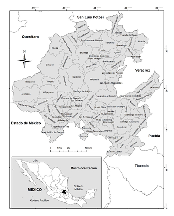
The state of Hidalgo is located in the central-eastern region of Mexico. Its coordinates are: north 21°24 ‘- 19°36' north; 97°58 '- 99°53' west. It is 20 846.5 km2 and stands for 1.1 % of the country's total area. It has 84 municipalities (Inegi, 2012a) (Figure 1).
Generation of the database
The variables that were associated for calculation of the occurrence of fires were identified from bibliographic reviews and consultations with state experts. A database was developed in the Excel program for the 84 municipalities of Hidalgo, with information for the 2000-2011 period (Table 1).
Table 1 Variables used to explain the forest fire incidence in Hidalgo State municipalities.

1 IDH = Human development index
The metheorological information was taken from the data base of the surface climatic stations of the México Climate Computing Project (CLICOM) managed by the Servicio Meteorológico Nacional (National Metheorological Service) (Cicese, 2015). The temperature and precipitation data were completed with the method proposed by Gómez et al. (2008) and the isoyettes and isotherms of Inegi (2015a) were also taken into account.
The statistical variables (production, number of fires and surface area) and the road network were compiled from the Anuario Estadístico y Geográfico de Hidalgo (Hidalgo Statistical and Geographic Yearbook) (Inegi, 2015a).
Municipal areas and land use were determined by using the Sistema de Información Geográfica ArcGis 10.1 (ESRI, 2012) (Geographic Information System) (ESRI, 2012), based on the Áreas Geoestadísticas Municipales (Geographic Statistics Areas) (Inegi, 2012b) map, which is the result of the Inventario Forestal Nacional 2000 (Semarnat, 2001) (National Forest Inventory 2000) (Semarnat, 2001) and the Cartas de Uso del Suelo y Vegetación de Inegi escala 1:250 000 (Inegi Soil and Vegetation Use Scale scale maps1: 250 000) (Inegi, 2015b) (Table 2).

The annual area information was estimated from a rate of change that was assumed linear and was obtained from cartographic products of different years. For example, if between one map and another edited five years apart, there was a reduction of 1 000 ha in forest area, the reduction rate was 200 ha year-1.
The data about the social variables were consulted from the electronic page of the Departamento de Estadística, Matemática y Cómputo de la Universidad Autónoma Chapingo (Statistics, Mathematics and Computation of Chapingo Autonomous University) (DEMYC, 2015). They were completed with the PNUD reports (2006, 2009, 2012). Since the social indexes were calculated every 5 years (2000, 2005 and 2010), a rate of annual municipal change was determined in a similar way to what was pointed out for the maps.
When working with such a large set of variables, the possibility of multicollinearity increases, in order to reduce its possible effects, the SAS 9.0 statistical package (SAS, 2002) carried out exploratory analyzes and correlation matrices, using the Pearson coefficient among all the variables. The explanatory types that correlated with each other were eliminated.
In addition, since the 22 municipalities did not have fires in record during the study period, and one has not forest area, it was decided to remove them from the analysis. After depuration, the data base was made up by 732 observations and 77 variables: four about the number of fires and the area the affect and response variables and 73 independent variables referring to the sociodemographic and territorial characteristics.
Later, another correlation analysis was made in order to know the relationship between the independent variables and the response ones; as expected, the values of the coefficient were low, in general, even if they were considered the greatest values to select one 10 variables and use them for the logistic regression: mean average temperature of the maximum temperature of the season, number of lambs, number of goats, number of cows, forest area, disturbed areas, life expectancy, length of the roads and Gross Domestic Product per capita. All the variables that were previously selected were significant with an α=0.05.
Statistical model
The logistic model has been used in different analyzes to estimate the occurrence of forest fires at regional or local scales, by generating predictive and explanatory models, by knowing the most important variables in the phenomenon (Carvacho, 1998).
For the statistical analysis of forest fire probability, the logistic regression model of Hosmer and Lemeshow (2000) was used:
Where:
P |
= Probability of forest fire occurrence |
e |
= Basis of natural logarithms |
α |
= Ordinate to the origin |
β1 |
= Constant related to X1 as independent variable and thus until β n Xn |
This method requires a binomial dependent variable; therefore, the continuous variable number of forest fires was transformed, assigning the value 0 when a fire did not occur and 1 when there was at least one during the year. The analysis was performed using the logistic procedure (Proc logistic) of the SAS 9.0 program (SAS, 2002) for microcomputers.
To evaluate if the parameters were significant, the estimated parameters were examined, in addition to using the values of the χ2 test and the Wald statistic. The 10 previously selected variables were "backward" stepwise and alternated one by one, until they were found to have no statistically significant differences (p ≤ 0.05) in the model. Finally, four variables were selected: two of land use, disturbed area (apertur) and forest area (supbosq); in addition, two social, longcarr and GDP per capita (pib_p_c). Few variables were chosen because it was intended to achieve a meaningful model, but that its use was not complex.
The apertur, supbosq and pib_p_c variables were categorized from a cut-off point, 10 000 for the three variables (Table 3). The value chosen for the cut corresponds to its proximity to the averages of the explanatory variables: area with forest (11 481 ha), disturbed area (13 531 ha) and GDP per capita (US$ 7795). The variable longcarr remained continuous.

Construction of the fire occurrence model for Hidalgo State
A scale of fire occurrence was made (Table 4), in regard to the obtained values for the probability of forest fire occurrence (P); and they were included in a map.

Results and Discussion
Logistic model
The best model included four variables: forest area (supbosq), GDP per capita (pib_p_c), length of the roads (longcarr), with positive influence and disturbed areas surface (apertur), with negative influence; Table 5 shows the estimated coefficients and variables in the model.
Table 5 Variables included in the model and regression coefficients and confidence intervals.

g.l. = Degrees of freedom; p = Probability
Where:
P |
= Probability of forest fire occurrence |
e |
= Euler number (2.7182) |
supbosq |
= Forest area (ha) |
pib_p_c |
= GDP per capita ($ person-1) |
longcarr |
= Length of the roads (km) |
apertur |
= Disturbed areas surface (ha) |
Most of the signs of the coefficients for each variable are logical, according to the previous knowledge that exists about the causes of forest fires in Mexico. For the disturbed area, the relation is not what was expected, whose coefficient is negative. Rodríguez et al. (2008) recorded a positive relation between the disturbed areas and the affected area, at a national scale.
The significant variables in this study, in part, confirm what other studies have documented for some federative entities, for example: Román and Martínez (2006), Carrillo et al. (2012) and Pérez-Verdín et al. (2013) state that the density of roads is one of the anthropic factors related to the incidence, distribution and size of the fire in Chiapas, Puebla and Durango States, respectively.
At the global level, there are also coincidences with the results of the present study: Guo et al. (2015), through logistic regression analysis, indicate that the heterogeneity of the distribution of forest fires is caused by altitude, nearness to train tracks, forest type and temperature in the Daxing'an Mountains, China. Chas et al. (2012) studied the spatial pattern of fires in the region of Galicia, Spain. They observed that high demographic pressure, communal property, large number of roads and access roads to the forest increase the likelihood of a conflagration; while with the establishment of forest plantations the risk decreases.
Cardille et al. (2001) applied generalized linear regression to abiotic, biotic, and human variables to determine which best explain the fire activity in the midwest region of the United States of America. Their results evidenced that the combination of the three groups of variables was related to the spatial distribution of fire, but they emphasized that the areas with greater population density, of roads and with the shortest distance to non-forest areas were more prone to conflagrations.
The forest area variable was positively related to the occurrence of forest fires, partly due to the presence of forest fuels that exist in woods, which increases the fire hazard. Among the works that have reported similar trends, is that of Guo et al. (2015).
The center and south of Hidalgo has the highest concentration of population and economic development above the rest of the state, coincidentally, in that area the highest number of fires is recorded. The development of the region implies the promotion of programs of productive activities that are better remunerated and generate enough income for families to have access to higher levels of consumption that also lead to more dynamic economies.
In this regard, the region has a high degree of human development on average (associated with high GDP per capita) (PNUD, 2014). It is possible that the direct relationship between fire probability and GDP per capita can be explained because this variable may also involve a wider range of activities, including the use of fire in or near the forest, as part of agricultural practices.
Apparently, the GDP per capita variable had not been recorded as significant in a fire probability model; Although they have contributed in this sense variables such as the human development index by gender, which at national level Rodríguez et al (2008) indicate an inverse relation with respect to the area affected by fires and the total forest area. It emphasizes that more economic development can increase the fires, but a greater human development has an opposite effect.
Forest fires are mainly recorded during the months of March to May, possibly because of the lack of precaution during the use of fire in agricultural activities, which coincide with the dry season, as well as the negligence of walkers and hikers during their visits to the woods. Under these circumstances, the length of roads and highways becomes highly relevant, as it can be linked both to the increase in the accessibility of different areas to start a fire by accident or negligence, as well as to the burning of vegetation that is carried out on the roads.
The same thing happens in pinewoods located on roadsides, where from vehicles are thrown butts (Rodríguez, 2014). An example of this happens in the road of the tourist corridor of Pachuca and the one of Pachuca to Real del Monte, where it is common to see areas burned in its edges.
In Hidalgo, Conafor and the State Government provide support in different areas to rehabilitate areas with fire disturbances and other factors (Semarnat, 2016). Such is the case today, during the years covered by this research, policies were developed to recover the forest area for the prevention and awareness of the importance of conserving forest ecosystems.
Thus, during 2003-2010, the Mexican government allocated $ 5 289 000 000.00 under the Environmental Services scheme in an area of 2 767 000 ha (Iglesias et al., 2010). The amount for payment of environmental services in the state of Hidalgo in the 2005-2011 period itwas $ 46,656,674 (Conafor, 2017a, 2017b), for an approved area of 22 180 ha (Semarnat, 2011); in 2003 and 2004 no such benefit was granted.
These actions partially explain the negative influence of the area of disturbed areas variable in the occurrence of forest fires, since there are other options such as community forest management, whereby many rural communities care for reforested areas and actively participate to reduce the probability of being burned by a fire, and the one that is being explored in Mexico, is the integral fire management (Rodríguez, 2000, 2015).
Degree of forest fire occurrence
In Figure 2 are shown the degrees of forest fire occurrence for the municipalities of Hidalgo, in regard to the area per class and to the forest area of the state.
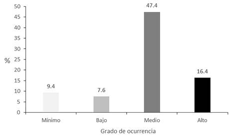
Figure 3 shows a map that expresses, on a probabilistic scale between 0 and 1, the estimated possibility of a fire occurring in a municipality, based on the historical variables of the model. The municipalities that appear in white are those that were not considered in the analysis because they did not have records of fires in the period of study or lack forest area, as it is the case of Tizayuca.

It is noteworthy that 39 municipalities are classified in a medium category and 10 in the high category; these areas are of interest in fire management strategies. It is observed that the municipalities with the highest probability of fires are located in the southeast of the state, in the regions of Apan, Tulancingo and Pachuca, mainly, but also in the municipalities Actopan, Tula de Allende, Zacualtipán de Ángeles and Zimapán.
The logistic model was plotted to better appreciate the effect of its explanatory variables (Figure 4). In the first case the value of the variable pib_p_c was set at 0 (low GDP), in the second example, the same variable had the value 1 (high GDP). The legend of the graph refers to a degree of occurrence of fire according to the color of the municipalities.
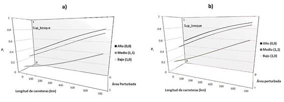
The values corresponding to forest area and disturbed area, 0 or 1 (low or high), respectively, are indicated in brackets. The probability of fires has a positive influence of the forest area, GDP per capita, length of roads variables; and negative effect of the disturbed area. It is suggested that each variable has an additive effect to the others to explain the phenomenon.
Conclusions
The most relevant variables to explain the probability of occurrence of fires and based on the value of their associated constants in the logistic model are the area of disturbed areas (negative influence), forest area (positive influence), Gross Domestic Product (positive influence) and the length of the roads (positive influence).
The results confirm the importance of the length of roads, since it shows a significant relation with the fires. The logistic regression model proved that the socioeconomic variable GDP per capita has a significant weight in the probability of occurrence of fires, so it is important to consider the human factor in the fire risk assessment in Hidalgo. The forest area positively influenced the probability of fires, but the area with disturbed areas has a negative effect.
The results are only valid for the municipalities of Hidalgo, as probably some of the model variables are not related to the occurrence in other regions of the country. It is considered that this work should be extended by generating other geographically weighted regression models for each of the study units in order to identify the variables whose coefficients vary significantly across the space. Likewise, the validation of the proposed model remains pending.
Forest fire patterns can contribute to the planning of fire management strategies, such as fire prevention, control and control, thereby ensuring that resources are directed to the areas most likely or at risk, or where fire must be reintroduced for conservation, restoration or silvicultural purposes. But it is necessary to emphasize that the answer must be not only to prevent and fight against unwanted fires, but also to stimulate community fire management, to make its ecological-silvicultural application, to use it to reduce the danger of unwanted conflagrations, to favor diversity, among many other goals; that is, an integral fire management.
Acknowledgements
To Conacyt and the Universidad Autónoma Chapingo.
REFERENCES
Ávila F., D., M. Pompa G., X. Antonio N., D. A. Rodríguez T., E. Vargas P. and J. Santillán P. 2010. Driving factors for forest fire occurrence in Durango State of Mexico: A geospatial perspective. Chinese Geographical Sciencie 20 (6): 491-497. [ Links ]
Cardille, J. A., S. J. Ventura and M. G. Turner. 2001. Environmental and social factors influencing wildfires in the Upper Midwest, USA. Ecological Applications 1 (1): 111-127. [ Links ]
Carrillo G. et al. 2012. Análisis espacial de peligro de incendios forestales en puebla, México. Interciencia 37 (9): 678-683. [ Links ]
Carvacho, L. 1998. Evaluación de la estimación de grandes incendios forestales en la cuenca mediterránea europea por redes neuronales y regresión logística. Pontificia Universidad Católica de Chile, Instituto de Geografía. Serie Geografía 7: 73-85. [ Links ]
Chas A., M. L., J. M. Touza, J. P. Prestemon and C. J. McClean. 2012. Natural and social factors influencing forest fire occurrence at a local spatial scale. In: Spano, D., V. Bacciu, M. Salis y C. Sirca (eds.). Modelling Fire Behavior and Risk. Global Fire Monitoring Center. Freiburg, Germany. pp. 181-186. [ Links ]
Chuvieco, E. and R. G. Congalton. 1989. Application of remote sensing and Geographic Information Systems to forest fire hazard mapping. Remote Sensing of Environment 29:147-159. [ Links ]
Centro de Investigación Científica y de Educación Superior de Ensenada (CICESE). 2015. Base de datos climatológica nacional (Sistema CLICOM). http://clicom-mex.cicese.mx/ (10 de agosto 2016). [ Links ]
Cochrane, M. A. 2003. Fire science for rainforests. Nature 421: 913-919. [ Links ]
Comisión Nacional Forestal (Conafor). 2012. Incendios forestales en México. Temporada 2013. http://www.conafor.gob.mx:8080/documentos/docs/7/4339Campa%C3%B1a%20de%20contra%20incendios%202013.pdf (15 de octubre 2015). [ Links ]
Comisión Nacional Forestal (Conafor). 2017a. Compensación ambiental Resultados. http://www.conafor.gob.mx/portal/index.php/tramites-y-servicios/apoyos/compensacion-ambiental/resultados (12 de mayo 2017). [ Links ]
Comisión Nacional Forestal (Conafor). 2017b. Reglas de operación ProÁrbol 2007. http://www.conafor.gob.mx:8080/documentos/ver.aspx?grupo=4&articulo=366 (12 de mayo 2017). [ Links ]
Departamento de Estadística, Matemática y Cómputo (DEMYC). 2015. Sitio de los Informes Nacionales de Desarrollo Humano en México. http://dicifo.chapingo.mx/demyc/idh/new/bases_new/?mod=nacional&inicio=1995&Consultar=Consultar (25 de febrero 2015). [ Links ]
Environmental Systems Research Institute (ESRI). 2012. Program ArcGis 10.1TM for desktop. Inc. Redlands, CA USA. n/p. [ Links ]
Fulé, P. Z. et al. 2002. Comparing ecological restoration alternatives: Grand Canyon, AZ, USA. Forest Ecology and Management 170: 19-41. [ Links ]
Gómez, J. D. et al. 2008. Spatial estimation of mean temperature and precipitation in areas of scarce meteorological information. Atmósfera 21(1): 35-56. [ Links ]
Guo, F. et al. 2015. Historic distribution and driving factors of human-caused fires in the Chinese boreal forest between 1972 and 2005. Journal of Plant Ecology 8(5): 480-490. [ Links ]
Hosmer, D. W. and S. Lemeshow. 2000. Applied logistic regression. Wiley. New York, NY USA. 392 p. [ Links ]
Iglesias, L. et al. 2010. Pago de servicios ambientales para conservar la biodiversidad. In: Carabias, J., J. Sarukhán, J. de la Maza y C. Galindo (coords.). Patrimonio natural de México: Cien casos de éxito. Conabio. México, D.F., México. pp. 176-177. [ Links ]
Instituto Nacional de Estadística y Geografía (Inegi). 2012a. Perspectiva estadística Hidalgo. Aguascalientes, Ags., México. 95 p. [ Links ]
Instituto Nacional de Estadística y Geografía (Inegi). 2012b. Áreas geoestadísticas municipales, 2012, escala 1:250000. Marco Geoestadístico 2013 versión 6.0c (Inventario Nacional de Viviendas 2012). Aguascalientes, Ags., México. s/p. [ Links ]
Instituto Nacional de Estadística y Geografía (Inegi). 2015a. Productos: Anuario estadístico y geográfico de Hidalgo. http://buscador.inegi.org.mx/search?requiredfields=cve_titgen:13&client=ProductosR&proxystylesheet=ProductosR&num=10&getfields=*&sort=meta:edicion:D:E:::D&entsp=a__inegi_politica_p72&lr=lang_es|lang_en&oe=UTF-8&ie=UTF-8&entqr=3&filter=0&site=ProductosBuscador&tlen=260&ulang=es&ip=10.210.100.253&access=p&entqrm=0&ud=1&q=+inmeta:Entidad%3DHidalgo&dnavs=inmeta:Entidad%3DHidalgo (15 de mayo de 2015). [ Links ]
Instituto Nacional de Estadística y Geografía (Inegi). 2015b. Productos: Cartas de Uso del Suelo y Vegetación escala 1:250 000. http://buscador.inegi.org.mx/search?requiredfields=cve_titgen:3587&client=ProductosR&proxystylesheet=ProductosR&num=10&getfields=*&sort=meta:edicion:D:E:::D&entsp=a__inegi_politica_p72&lr=lang_es%7Clang_en&oe=UTF-8&ie=UTF-8&entqr=3&filter=0&site=ProductosBuscador&tlen=260&ulang=es&ip=10.152.21.8&access=p&entqrm=0&ud=1&q=+inmeta:escala_ficha%3D1%253A250%2520000&dnavs=inmeta:escala_ficha%3D1%253A250%2520000 (5 de octubre 2015). [ Links ]
Pérez-Verdín., G., M. A. Márquez L ., A. Cortés O. y M. Salmerón M. 2013. Análisis espacio-temporal de la ocurrencia de incendios forestales en Durango, México. Madera y Bosques 19(2): 37-58 [ Links ]
Programa de las Naciones Unidas para de Desarrollo (PNUD). 2006. Indicadores de Desarrollo Humano y Género en México, D. F., México. 274 p. [ Links ]
Programa de las Naciones Unidas para de Desarrollo (PNUD). 2009. Indicadores de Desarrollo Humano y Género en México 2000-2005. México, D. F., México. 465 p. [ Links ]
Programa de las Naciones Unidas para de Desarrollo (PNUD). 2012. El Índice de Desarrollo Humano en México: cambios metodológicos e información para las entidades federativas. México, D. F., México. 20 p. [ Links ]
Programa de las Naciones Unidas para de Desarrollo (PNUD), 2014. Índice de Desarrollo Humano Municipal en México: nueva metodología. México, D. F., México. 104 p. [ Links ]
Rodríguez T., D. A. 2000. Educación e incendios forestales. Mundi Prensa, UACH. México, D. F., México. 201 p. [ Links ]
Rodríguez T., D. A. and P. Z. Fulé. 2003. Fire ecology of Mexican pines and a fire management proposal. International Journal of Wildland Fire 12(1): 23-37. [ Links ]
Rodríguez T., D. et al. 2008. Factores que inciden en la siniestralidad de los incendios forestales. Revista Ciencia Forestal en México 33(104): 37-58. [ Links ]
Rodríguez T., D. A. 2014. Incendios de vegetación. Su ecología, manejo e historia. Vol. 1. Ed. Colegio de Postgraduados, Biblioteca Básica de Agricultura. Texcoco, Edo. de Méx., México. 891 p. [ Links ]
Rodríguez Trejo, D. A. 2015. Incendios de vegetación. Su ecología, manejo e historia . vol. 2. Ed. Colegio de Postgraduados, Biblioteca Básica de Agricultura. Texcoco, Edo. de Méx., México.814 p. [ Links ]
Román C., R. M. and J. Martínez V. 2006. Effectiveness of protected areas in mitigating fire within their boundaries: Case study of Chiapas, Mexico. Conservation Biology 20(4):1074-1086. [ Links ]
Statistical Analisys System (SAS). 2002. Programa para microcomputadoras (v9.0). SAS Institute Inc. Cary, NC USA. n/p. [ Links ]
Secretaría de Medio Ambiente y Recursos Naturales (Semarnat). 2001. Inventario Forestal Nacional 2000. México,D.F., México. s/p. [ Links ]
Secretaría de Medio Ambiente y Recursos Naturales (Semarnat). 2016. Apoyos 2015. Programa Nacional Forestal Pronafor. Áreas elegibles. Hidalgo. http://www.conafor.gob.mx/web/apoyos/apoyos-2015/ (10 de diciembre 2015). [ Links ]
Secretaría de Medio Ambiente y Recursos Naturales de Hidalgo (Semarnath). 2011. Programa estatal forestal 2011-2016. Secretaría de Planeación, Desarrollo Regional y Metropolitano del Gobierno del Estado de Hidalgo. Pachuca, Hgo., México. 51p. [ Links ]
Whelan, R. J. 1995. The ecology of fire. Cambridge University Press. Cambridge, UK. 360 p [ Links ]
Received: January 21, 2016; Accepted: April 23, 2017
 Este es un artículo publicado en acceso abierto bajo una licencia Creative Commons
