


![Environmental suitability areas for [Bouteloua curtipendula (Michx.) Torr.] in Mexico due to climate change effect](/img/en/prev.gif)


Services on Demand
Journal
Article
 text in
  English (pdf)
 Article in xml format
 Article references
 Send this article by e-mail
Indicators
-
 Cited by SciELO
 -
 Access statistics
Related links
-
 Similars in
SciELO
Similars in
SciELO
Share

 Permalink
Revista mexicana de ciencias pecuarias
On-line version ISSN 2448-6698Print version ISSN 2007-1124
Rev. mex. de cienc. pecuarias vol.11 suppl.2 Mérida Mar. 2020 Epub June 30, 2020
https://doi.org/10.22319/rmcp.v11s2.4694
Articles
Effects of rainfall pattern changes due to global warming on soil water erosion in grasslands and other vegetation types in the state of Zacatecas, Mexico
a Instituto Nacional de Investigaciones Forestales Agrícolas y Pecuarias (INIFAP). Campo Experimental Zacatecas, Km 24.5 Carretera Zacatecas-Fresnillo, Calera, Zac., México.
b Universidad de Guadalajara. Centro Universitario de Ciencias Biológicas y Agropecuarias. Camino Ramón Padilla Sánchez No. 2100 Nextipac, 44600, Zapopan, Jalisco, México.
Temperature and precipitation anomalies were used to assess it for the 2021-2080 period, based on an assembly of 11 global circulation models, in order to generate future temperature and precipitation maps based on the reference climatology of the 1961-2010 period. In the state of Zacatecas, the grassland area has current average erosion values of approximately 16.3 t/ha, estimated using the RUSLE model. In other types of vegetation or land use as shrubs, forest or agricultural areas, values are even higher (50.74, 65.99, 161.39, t/ha/yr, respectively). The application of the ensemble model in RCP 4.5 and RCP 8.5 indicates that there will be an increase in temperature and a decrease in rainfall. In a scenario with less effect of global warming (SPC 4.5), a gradual reduction of grassland water erosion is expected, compared to 2010 of 2.3 % in 2030 (15.67 t/ha/yr) to 5.8 8% (15.18 t/ha /yr) in 2070. In the same period up to 2070, the rate of decline of water erosion is 14.1 kg/ha/yr. RCP 8.5, which was designed for a condition of continuous emission of greenhouse gases, exhibits even greater reduction values and for 2070 it establishes a decrease of 13.0 %, with an erosion reduction rate of 31.5 kg/ha/yr. Other types of vegetation and land use showed the same tendency to decrease, although at higher rates. The scenario of water erosion reduction seems favorable; however, an increase in soil loss values due to wind erosion in the arid regions of northern Zacatecas is not ruled out. The assessment of levels of water erosion contributes to the ordering of land use to reduce levels of degradation and desertification.
Key words Water erosion; RUSLE; Climate change; RCP
Para evaluar la erosión hídrica se utilizaron anomalías de temperatura y precipitación para el período 2021-2080, estimadas con un ensamble de 11 modelos de circulación global, para generar mapas de temperatura y precipitación futuras a partir de la climatología de referencia 1961-2010. En el caso del estado de Zacatecas el área de pastizal presenta valores promedio actuales de erosión del orden de 16.3 t/ha, estimadas mediante el modelo RUSLE. En otros tipos de vegetación o usos del suelo como es el matorral, bosque o el área agrícola se generan valores aún mayores (50.74, 65.99, 161.39, t/ha/año, respectivamente). La aplicación del modelo ensamble en las RCP 4.5 y RCP 8.5 indica que habrá un incremento en la temperatura y una disminución de la lluvia. En un escenario de menor efecto de calentamiento global (RCP 4.5) se espera una reducción gradual de erosión hídrica del pastizal respecto a 2010 de 2.3 % en 2030 (15.67 t/ha/año) hasta un 5.88% (15.18 t/ha/año) en 2070. En el mismo periodo hasta 2070, la tasa de decremento de erosión hídrica es de 14.1 kg/ha/año. La RCP 8.5, que fue diseñada para una condición de continua emisión de gases de invernadero, presenta valores de reducción aún mayores y para 2070 establece una disminución del 13.0 %, con una tasa de disminución de erosión de 31.5 kg/ha/año. Otros tipos de vegetación y uso del suelo mostraron la misma tendencia de disminución, aunque en tasas de decremento más altas. Aunque el escenario de disminución de erosión hídrica parece favorable, no se descarta un incremento de valores de pérdida de suelo por efecto de erosión eólica en las regiones áridas del norte del estado de Zacatecas. La valoración de niveles de erosión hídrica contribuye al ordenamiento del uso del suelo para reducir niveles de degradación y desertificación.
Palabras clave Erosión hídrica; RUSLE; Cambio climático; RCP
Introduction
Soil water erosion is only one of the possible types of erosion and one of the forms of soil degradation that exist. In particular, water erosion is a continuous process that affects the soils of the entire planet. Changes in the amount, intensity and distribution of rainfall accelerate or reduce the continuous effect of erosion. These changes are currently occurring as a result of the increase in greenhouse gases (GHG), which influence global warming1 and climate change.
Soil losses from water erosion are of greater importance, especially in places where the surface layer is shallow, as in the state of Zacatecas. Grassland soils are very shallow, while agricultural soils are deeper. The effect of soil losses will vary according to the land use, but in all cases it will lead to the gradual reduction of productivity and degradation.
There is great uncertainty about the effects that climate change will cause in productive activities, as these activities and, consequently food security, depend on rainfall. However, indicators such as water erosion may not be of general interest, especially those indicators that are not routinely measured and whose effects, due to permanent occurrence, are not readily noticeable. Current and future knowledge of possible land losses and degradation in general are important for land use planning and management2. The glossary of the American Society of Soil Science3 defines degradation as: "the process through which a compound is transformed into simpler components". Desertification was defined in 1992 by the United Nations Convention to Combat Desertification as: "the degradation of drylands, semi-arid and dry sub-humid lands, resulting from various factors, such as climatic variations and human activities"4. CONABIO5 mentions that in 2011, the surface area of the country's natural ecosystems has been significantly reduced since the middle of the last century to become agricultural land, urban areas and infrastructure works, and that 28.7% of the territory had lost its natural ecosystems, while the remaining 71.3% maintained them with different degrees of conservation. Therefore, land use planning is essential to preserve stable levels of degradation and desertification through the maintenance of the agricultural frontier, and to minimize changes in land use. In this sense, it is important to evaluate the effect of climate change on the levels of water erosion in the areas of grassland and other types of vegetation, in order to contribute to the planning of protection actions, ecological management and reduction of soil degradation.
Material and methods
The state of Zacatecas is located between the coordinates 25° 07´32´´ and 21°01´48´´ N, and between 100° 44´ 09´´ and 104° 24´08´´ W, and has a territory of 7´447,970.8 ha6. The prevailing vegetation type in the state is xerophytic scrubland, which covers 3´173,280 ha, followed by the surface area of agricultural land, with 1´746,987 ha; the third is the grassland, with a surface area of 1´454,234 ha, and the fourth is forest, which occupies 1´125,285 ha7; the rest is made up by tropical forest and different vegetation types of smaller size. The prevailing soil types in the state are 14 units, of which xerosol (38.8 %), litosol (14.3 %), pheozem (14.0 %), regosol (12.2 %) and castañozem (9.6 %)8 are the most important.
Water erosion
The current water erosion was estimated using the Revised Universal Soil Loss Equation (RUSLE)9:
Where:
E= soil loss per surface area unit (t/ha/yr);
R= rain erosivity factor (MJ mm ha-1 h-yr-1);
K= soil erodibility factor (t ha-1 h-1/MJ mm ha-1);
L= slope length factor (non-dimensional);
S= slope degree factor (non-dimensional);
C= vegetation factor (non-dimensional);
P= mechanical practice factor of erosion control (non-dimensional).
The IDRISI Selva software10 was used to measure it; this software includes the RUSLE command, which is a routine that improves the calculation of the L and S factors and including other additional routines that eliminates depressions, and well as others that allow a better generalization of the digital elevation model. The isoerosivity map, which divides the country into 14 regions, was used for estimating the R factor; the state of Zacatecas is located in regions 3, 4 and 7, whose equations are the following:
Where Y is the R factor in terms of MJ mm/ha h, and X is the annual precipitation in mm.
The values of the K parameter were estimated according to a table of erodibility values developed by Figueroa 11. The K factor is a function of the soil texture and class. These values were assigned to soil classes and textures within ejido lands, which were digitized to facilitate their management within geographic information systems (GIS), through the IDRISI Selva software10. The output is the soil loss for each vegetation type.
The effect of climate change was quantified using the information system of INIFAP for the Mexican Republic 12, which consists of the climate data base of the 1961-2010 period and the climate scenarios predicted for the years 2021 to 2080 in the Representative Concentration Routes (RCP) 4.5 and 8.5 of greenhouse gases (GHG) for, among others, an ensemble model formed from 11 general circulation models (GCM) ―reduced in scale and calibrated13― selected for Mexico (BCC ‐ CSM1‐ 1, CCSM4, GISS ‐ E2 ‐ R, HadGEM2 ‐ AO, HadGEM2 ‐ ES, IPSLCM5A ‐ LR, MIROC ‐ ESM ‐ CHEM, MIROC ‐ ESM, MIROC5, MRI ‐ CGCM3, NorESM1 ‐ M).
The values of maximum temperature, minimum temperature and monthly precipitation were used for the years 2021 to 2080. The annual data for the climatic scenarios 2021-2040, 2041-2060 and 2061-2080, hereinafter referred to as climatologies or 2030, 2050 and 2070 years, respectively, were estimated based on the monthly data.
The information of INEGI 14 on land use made it possible to divide the effects of rainfall and water erosion by predominant vegetation type, including grasslands as well as areas covered with other types of vegetation such as scrubs and forests, and agricultural land. With the information of water erosion estimated for the present and for the years 2030, 2050 and 2070, regression models15 were obtained for the main vegetation types of the state, mentioned above, calculating an annual rate of change for each condition of vegetation and comparing it with that of the grassland area, in order to determine where the greatest impacts due to climate change will potentially occur.
Results and discussion
Unlike other change indicators, soil loss from water erosion will have a tendency to diminish as the global warming effect triggers a reduction of rainfall in the state of Zacatecas. Table 1 shows the areas susceptible to water erosion and the range of soil loss associated with each of them, both in the reference climatology and in the studied climatologies and climate change scenarios. The scenarios used to project the rainfall, on which the estimation of water erosion values was based, are those referred to as representative routes of greenhouse gas concentration (RCP) 4.5 and 8.5, for the 2030, 2050 and 2070 climatologies. The RCPs are characterized by their approximate calculation of the total radiative forcing expected for the year 2100 in relation to that of the year 1750 (IPCC, 2013), i.e. 4.5 W m-2 in the RCP 4.5 scenario (intermediate GHG emissions), and 8.5 Wm-2 in the RCP 8.5 scenario (high GHG emissions).
Table 1 Land loss surface areas (ha) associated with grasslands, estimated for RCP 4.5 with the RUSLE model for the state of Zacatecas from 2010 to 2070
| Erosion (t/ha) | Years | Difference (%) | |||
|---|---|---|---|---|---|
| 2010 | 2030 | 2050 | 2070 | ||
| 0 - 10 | 888,417 | 894,767 | 906,833 | 911,278 | 2.57 |
| 10 - 100 | 533,431 | 529,621 | 519,460 | 514,380 | -3.57 |
| 100 - 500 | 30,482 | 27,942 | 26,036 | 26,671 | -12.50 |
Table 2 shows the surface projections associated with the range of soil loss under CPR 8.5, which is the condition in which no decrease in greenhouse effect is expected. Figure 1 shows the changes in water erosion in the grassland areas of the state of Zacatecas with RCP 4.5 and 8.5.
Table 2 Land loss areas (ha) associated with pastures, estimated for CPR 8.5 with the RUSLE model for the state of Zacatecas from 2010 to 2070
| Erosion (t/ha) | Years | Difference (%) | |||
|---|---|---|---|---|---|
| 2010 | 2030 | 2050 | 2070 | ||
| 0 - 10 | 888,417 | 910,643 | 930,329 | 939,220 | 5.72 |
| 10 - 100 | 533,431 | 515,015 | 502,949 | 494,059 | -7.38 |
| 100 - 500 | 30,482 | 26,671 | 19,051 | 19,051 | -37.50 |
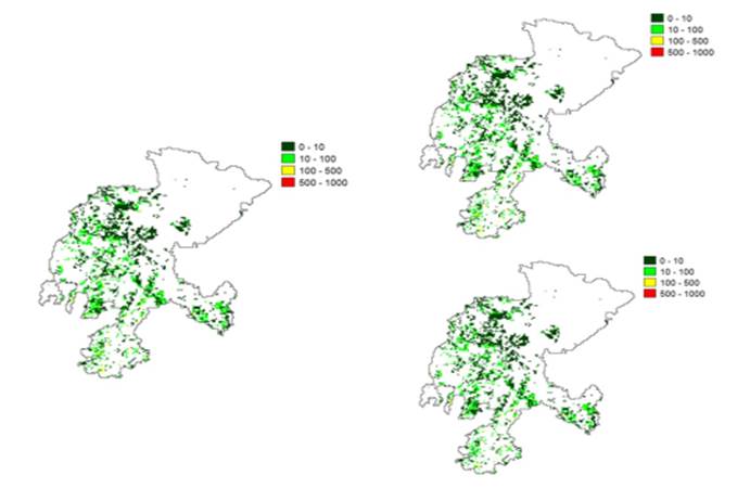
Figure 1 Current water erosion (left) and water erosion projected for 2070 (upper right) with RCP 4.5 and RCP 8.5 (lower right) in the grasslands of the state of Zacatecas
In both Tables (1 and 2) the figures show a similar trend: the category that represents the largest area in both tables is the one associated with the erosion range of 0 to 10 t/ha, which amounts to little more than 60 % of the total grassland area in the state of Zacatecas. In both RCPs, this category tends to increase: in RCP 4.5 it is increased by 22,861 ha (2.57 %), while in RCP 8.5, the increase is 50,803 ha, which represents approximately twice (5.72 %) the area estimated with RCP 4.5 for the year 2070.
A decrease in precipitation of 4.0 and 7.8 % (Tables 3 and 4) was projected for RCP 4.5 and RCP 8.5, respectively, up to the year 2070, which appears to be contradictory: as precipitation decreases, erosion increases. However, the categories with higher water erosion values, which range between 10 and 500 t/ha, will exhibit stability or even a decrease. Although the values of the categories 10-100 and 100-500, correspond to the lowest values in surface area (40 %), it was in these categories where the highest values of water erosion occurred, so that the stability and decrease in them leads to a decrease in the total mean values for the grassland area. When the average erosion values for the state of Zacatecas were used in a regression analysis, negative and, in both cases, significant exchange rates (P<0.05) were found, with small reduction values per year in RCP 4.5 (14.1 kg/ha/yr) and RCP 8.5 (31.5 kg/ha/yr (Figure 2).
Table 3 Mean precipitation projected with RCP 4.5 and percentage reduction in the 2010 -2070 period
| Land use | Years | Reduction (%) | |||
|---|---|---|---|---|---|
| 2010 | 2030 | 2050 | 2070 | ||
| Grassland | 500 | 492 | 483 | 480 | 4.04 |
| Scrubland | 385 | 377 | 370 | 367 | 4.53 |
| Agriculture | 469 | 462 | 454 | 450 | 4.03 |
| Forest | 602 | 591 | 580 | 580 | 3.76 |
Table 4 Mean precipitation projected with RCP 8.5 and percentage reduction in the 2010 - 2070 period
| Land use | Years | Reduction (%) | |||
|---|---|---|---|---|---|
| 2010 | 2030 | 2050 | 2070 | ||
| Grassland | 500 | 482 | 464 | 461 | 7.87 |
| Scrubland | 385 | 369 | 353 | 351 | 8.81 |
| Agriculture | 469 | 452 | 436 | 432 | 7.88 |
| Forest | 602 | 580 | 557 | 551 | 8.55 |

Figure 2 Soil annual average loss in the grasslands of the state of Zacatecas with RCP 4.5 (left) and RCP 8.5 (right)
Comparison with other vegetation types
The effect of the decrease in precipitation on the reduction of water erosion of the soil in the grasslands of Zacatecas is different from that of other types of vegetation in the state; assessment of the impact on the reduction of rainfall in the scrubland, forest and agricultural areas shows that the estimated values for the scrubland area are the lowest (Table 3), although the pattern is similar to that projected for the grasslands. Table 3 lists the estimated precipitation values for each type of vegetation and the percentage reduction. The reduction values are lower for RCP 4.5 than for RCP 8.5, because the former is associated with a lower effect of greenhouse gases (GHG). The reduction in precipitation values affects the average erosion values of the different types of vegetation studied.
Tables 5 and 6 show the reduction in mean values of water erosion estimated using RCP 4.5 and RCP 8.5. Table 5 shows a decrease in percentage of 5 to 9 % of current values (2010); this is most prominent in the grasslands, where the values range from 16.13 to 15.18 t/ha/yr, amounting to a 5.89 % reduction in 60 yr and showing the lowest values among all vegetation types. However, this projection may be altered by changes in land use. Grazing is carried out in this area, which is thereby subject to risks of deterioration, especially when overgrazing occurs16; this has been recognized as one of the main causes of increased runoff and water erosion, since, by reducing the vegetation cover, infiltration is reduced and runoff increases17. The decrease in the vegetation cover can also be associated with the reduction of precipitation. Long periods of drought have been recognized as causing and contributing to the increase in erosion. The risk that the change of land use entails for the grasslands has been shown in the reports of land use change rates as they were converted to irrigation agriculture areas during the 1970s, in what was formerly the grassland area within the “Chupaderos” aquifer in the state of Zacatecas, where the said rates were up to 1,913 ha/yr18 and 678 ha/yr in the Aguanaval aquifer18. A change in land use can induce changes in water erosion of a grassland area to erosion values typical of the agricultural area, whose average values range from 133 to 161 t/ha/yr.
Table 5 Average values of water erosion (t/ha/yr) by vegetation type with rainfall projected by means of RCP 4.5
| Vegetation types | Years | Difference (%) | |||
|---|---|---|---|---|---|
| 2010 | 2030 | 2050 | 2070 | ||
| Grassland | 16.13 | 15.67 | 15.29 | 15.18 | -5.89 |
| Scrubland | 50.74 | 49.76 | 48.62 | 48.11 | -5.18 |
| Forest | 65.99 | 64.47 | 61.24 | 61.46 | -6.86 |
| Agriculture | 161.39 | 157.32 | 146.35 | 145.56 | -9.81 |
Table 6 Average values of water erosion (t / ha / year) by vegetation type with rainfall projected by means of RCP 8.5
| Vegetation types | Years | Difference (%) | |||
|---|---|---|---|---|---|
| 2010 | 2030 | 2050 | 2070 | ||
| Grassland | 16.13 | 15.19 | 14.28 | 14.03 | -13.02 |
| Scrubland | 50.74 | 47.94 | 45.68 | 45.01 | -11.29 |
| Forest | 65.99 | 61.12 | 64.47 | 54.51 | -17.40 |
| Agriculture | 161.39 | 151.2 | 142.32 | 133.18 | -17.48 |
Likewise, it can be observed that average values of water erosion will decrease in the scrubland area and that they range from 5.18 to 11.29 %, which is related to the decrease in rainfall forecast for the coming years and whose exchange rates are significant (P<0.05). As in grasslands, overgrazing and changing land use are the greatest risks that this decrease in water erosion may not be as predicted. Another risk for this area is wind erosion, since it is in this type of vegetation that the lowest rainfall in the entire state will occur, which may favor the increase in wind erosion associated with drought19,20. A situation similar to the previous two will be observed in the forest area, where reductions in water erosion from 6.86 to 17.4 % are expected, without the exchange rates being significant (P>0.05). In this vegetation type, the felling of trees or soil change, as well as the effect of drought and diseases on trees, which have been found recently, can be seen as the greatest risks21.
Finally, mention is made of the case of the agricultural lands, which, since they are almost always located in the lowest part of the basin, are subject to runoff of greater magnitude and greater erosion. They are also the sites with the greatest depth of soil, which renders them the areas with the largest amount of soil losses. However, given the prospect of decreasing precipitation, it is estimated that water erosion values will decrease from 9.81 to 17.48 %, this area being the most benefited in terms of decreasing water erosion, with lower exchange rates (P>0.05). The appropriate management of the soil resource, the management of slopes, tillage techniques for soil conservation and maintenance of plant cover are technological components that contribute to improving soil care. However, traditional soil management practices, furrows in the direction of the slope and tillage during periods of intense winds, can increase the values of water and wind erosion. The latter has been reported11 as an erosion risk equivalent to that caused by runoff. The establishment of windbreak barriers and changes in tillage and moisture conservation techniques should be a priority to maintain agricultural productivity and not increase water erosion values, as predicted by the models used here. Additionally, attention should be paid to the reduction of authorizations for land use change, since, as mentioned above, the change in land use can lead to soil loss levels equivalent to those occurring in the agricultural area.
On the other hand, although it seems that the most notorious effects of land losses in Zacatecas, occur in the agricultural areas, land losses in other vegetation types are as much or more harmful than in the agricultural areas, because soil depth in grassland, forest or scrubland areas, are much smaller than in agricultural lands. Therefore, a decrease of one centimeter of surface layer of soil causes more dramatic effects in those other areas than in agricultural lands.
As mentioned at the beginning of this section in regard to soil losses due to water erosion, unlike other indicators, water erosion will tend to decrease as the global warming effect due to accumulation of gases in the atmosphere reduces precipitations in the state of Zacatecas. Results show that it is important to have information that may allow planning in the medium and long term, as well as expanding and including studies on related issues, such as wind erosion and other types of degradation associated with global warming, and other studies that may contribute to complete the understanding of the changes that will occur in the future and determine preventive actions and actions to care of the soil resource.
Conclusions and implications
The effect of the decrease in rainfall estimated for the state of Zacatecas will reduce the soil losses in the grassland areas and among the main vegetation types in the state. The average values of water erosion are lower in the grassland areas, followed by the areas of scrubland, forest, while the highest values are found in the agricultural lands, although the impact on these last two categories is lower. Land use change towards agricultural activities can lead to potential losses of land equivalent to the average values. The effects of the decrease in precipitation on soil losses due to wind erosion and other types of soil degradation should be assessed.
Literatura citada
1. IPCC. Climate Change 2014: Synthesis Report. Contribution of Working Groups I, II and III to the Fifth Assessment Report of the Intergovernmental Panel on Climate Change [Core Writing Team, RK Pachauri and LA Meyer editors]. IPCC, Geneva, Switzerland. 2014. [ Links ]
2. Echavarría CFG, Medina GG, Rumayor RAF, Serna PA, Salinas, GH, Bustamante WJG. Diagnóstico de los recursos naturales para la planeación de la intervención tecnológica y el ordenamiento ecológico. INIFAP. CIRNOC. Libro Técnico Nº10. 2009. [ Links ]
3. Soil Science Society of America. Glossary of soil terms. SSSA. Madison, WI. 53711. 1997. [ Links ]
4. UNCED. Earth summit agenda 21: Program of action for sustainable development. New York. United Nations Department of Public Information. 1992. [ Links ]
5. Comisión Nacional para el Conocimiento y Uso de la Biodiversidad. Quinto Informe Nacional de México ante el Convenio sobre la Diversidad Biológica (cdb). Conabio. México. 2014. [ Links ]
6. Secretaría de Medio Ambiente y Recursos Naturales. Inventario Estatal Forestal y de Suelos. Colección de inventarios forestales y de suelos. 2013-2014. México, DF. 2014. [ Links ]
7. INEGI (Instituto Nacional de Estadística y Geografía). Anuario estadístico y geográfico de Zacatecas. Aguascalientes, Ags. 2014. [ Links ]
8. INEGI. Conjunto de datos vectoriales. Edafología. Continuo Nacional. Escala 1:1´000,000. 1998. [ Links ]
9. Renard KG, Foster GR, Weesies GA, McCool DK, Yoder DC. Predicting soil erosion by water: A guide to conservation planning with the Revised Universal Soil Loss Equation (RUSLE), Agricultural Handbook, 703. U.S. Government Printing Office, Washington, DC. 1997. [ Links ]
10. Eastman JR. Idrisi Selva manual. Versión 17. Clark labs Clark University. Worcester, Mass., USA. 2012. [ Links ]
11. Figueroa SB, Amante AO, Cortés HGT, Pimentel JL, Osuna ESC, Rodríguez JMO, Morales FJF. Manual de predicción de pérdidas de suelo por erosión. SARH Colegio de postgraduados. México, DF. 1991. [ Links ]
12. Ruiz-Corral JA, Medina-García G, Rodríguez-Moreno VM, Sánchez-González JJ, Villavicencio GR, Durán Puga N, Grageda GJ, et al. Regionalización del cambio climático en México Rev Mex Cienc Agríc Pub. Esp. Núm. 2013;13:2451-2464. [ Links ]
13. Walton D. Meyerson J. Neelin JD. Accessing, downloading, and viewing CMIP5 data. Earth System Grid Federation. 25 p. IPCC (Intergovernmental Panel on Climate Change). 2013. The physical science basis. Working group, I contribution to the fifth assessment report of the intergovernmental panel on climate change. Summary for policymakers. In: Stocker TF, et al editors. Switzerland. 2013. [ Links ]
14. INEGI. Conjuntos de datos de la Serie V de Uso del Suelo y Vegetación, escala 1:250 000. 2013. [ Links ]
15. SAS Institute Inc. SAS 9.3. Cary, NC: SAS Institute Inc. 2011. [ Links ]
16. Echavarría CFG, Serna PA, Bañuelos VR. Influencia del sistema de pastoreo con pequeños rumiantes en un agostadero del semiárido Zacatecano: II Cambios en el suelo. Téc Pecu Méx 2007;45(2):177-194. [ Links ]
17. Serna PA, Echavarría CFG. Caracterización hidrológica de un pastizal comunal excluido al pastoreo en Zacatecas, México. I. Pérdidas de suelo. Téc Pecu Méx 2002;40(1):37-53. [ Links ]
18. Echavarría CFG. Recurso suelo, clasificación, uso, degradación y disponibilidad. En: Mojarro DF, et al., editores. Agua subterránea en Zacatecas. Universidad Autónoma de Zacatecas. México, DF. 2013:97-133. [ Links ]
19. Eltaif NI, Gharaibeh MA. Aplicación de un modelo matemático para predecir y reducción de la erosión eólica en tierras áridas no protegidas. Revista Chapingo Serie Ciencias Forestales y del Ambiente, Volumen XVII, Edición Especial: 2011;195-206. [ Links ]
20. Aimar SB, Méndez MJ, Buschiazzo DE. Predicción de la erosión eólica potencial con el modelo EWEQ en dos suelos loesicos: efectos de las condiciones climáticas. CI. SUELO 2011;29(2):253-264. [ Links ]
21. Moore B, Allard G. Los impactos del cambio climático en la sanidad forestal. Organización de las Naciones Unidas para la Agricultura y la Alimentación. Departamento Forestal. FAO. 2009. [ Links ]
Received: November 12, 2017; Accepted: August 22, 2018
 Este es un artículo publicado en acceso abierto bajo una licencia Creative Commons
