


Servicios Personalizados
Revista
Articulo
 texto en
  Inglés (pdf)
 Artículo en XML
 Referencias del artículo
 Enviar artículo por email
Indicadores
-
 Citado por SciELO
 -
 Accesos
Links relacionados
-
 Similares en
SciELO
Similares en
SciELO
Compartir

 Permalink
Revista mexicana de ciencias agrícolas
versión impresa ISSN 2007-0934
Rev. Mex. Cienc. Agríc vol.14 no.3 Texcoco abr./may. 2023 Epub 19-Jun-2023
https://doi.org/10.29312/remexca.v14i3.3085
Articles
Agroclimatic characterization of the crop of Agave tequilana Weber in the ravine of the Santiago River
1Instituto de Botánica-Universidad de Guadalajara.
2Departamento Ingeniería Forestal, Laboratorio de Selvicultura, Dendrocronología y Cambio Climático. DendrodatLab-ERSAF-Universidad de Córdoba, España.
3Departamento de Producción Forestal-Universidad de Guadalajara.
4Departamento de Ciencias Ambientales-Universidad de Guadalajara.
In its beginnings the production of tequila used different species of agaves, over time Agave tequilana Weber consolidated itself as a unique species for presenting better characteristics for its cultivation and production of sugars. The Ravine of the Santiago River is considered the place of origin of the Agave tequilana plant and of the preparation process of the drink that is now known as Tequila. Based on what was declared by the United Nations Educational, Scientific and Cultural Organization, the Agave Landscape and the Ancient Industrial Facilities of Tequila as cultural heritage of humanity. The spatial and temporal characterization of the climatological and edaphic information available for a particular region allows understanding the type of management that farmers practice on their crops, evaluating their restrictions and possible effects on production and the environment. The objective of this work was to know the environmental conditions under which the current and potential plantations of the A. tequilana crop are distributed in the Canyon of the Santiago River and specifically the part that includes the agave landscape. It was detected that in the ravine more than 50% of the agave plantations were in steep terrain without soil conservation practices, which causes its loss and contamination with agrochemicals to the ravine ecosystem, considered as a natural attraction to be conserved within the Agave Landscape.
Keywords: Agave tequilana Weber; agroecology; ravine of the Santiago River; tequila
En sus inicios la producción de tequila utilizó diferentes especies de agaves, con el tiempo el Agave tequilana Weber se consolidó como especie única por presentar mejores características para su cultivo y producción de azúcares. La Barranca del Río Santiago es considerada como el lugar de origen de la planta de Agave tequilana y del proceso de elaboración de la bebida que hoy se conoce con el nombre tequila. A partir de lo declarado por la Organización de las Naciones Unidas para la Educación la Ciencia y la Cultura, el paisaje agavero y las antiguas instalaciones industriales de tequila como patrimonio cultural de la humanidad. La caracterización espacial y temporal de la información climatológica y edáfica disponible para una región en particular permite comprender el tipo de manejo que los agricultores practican sobre sus cultivos, evaluar sus restricciones y posibles efectos en la producción y en el medio ambiente. El objetivo de este trabajo fue conocer las condiciones ambientales bajo las cuales se distribuyen las plantaciones actuales y potenciales del cultivo de A. tequilana en el Cañón del Río Santiago y de manera específica la parte que incluye el paisaje agavero. Se detectó que en la barranca más de 50% de las plantaciones de agave se localizaron en terrenos escarpados sin prácticas de conservación de suelo lo que provoca su pérdida y contaminación con agroquímicos al ecosistema barranqueño, considerado como un atractivo natural a conservar dentro del paisaje agavero.
Palabras clave: Agave tequilana Weber; agroecología; barranca del Río Santiago; tequila
Introduction
The possibility of obtaining food, drink, protection, shelter, tools, fibers and a wide variety of natural products from the agave plant contributed to the development of great civilizations in central and southern Mexico. The most widespread use of the plant is the production of agave liquor, which is made from the fermentation and distillation of the juice extracted from the stems or cooked heads (Gentry, 1982), which corresponds to Tequila, which is the Mexican drink par excellence. Different historical sources refer to the use of other types of agaves for the production of the then called wine-mezcal, from which the process of selection and domestication of A. tequilana began.
On the slopes of the Ravine of the Santiago River, its cultivation began and the first taverns for the production of tequila were established, thanks to the quality and abundance of water that emanated from its ravines, and for being the ideal place to cover up the activity, which was considered illegal in colonial times (Pérez, 1887; Valenzuela, 1997, 2003; Gutiérrez, 2007; Jiménez, 2008; Muriá, 2016). It is in this area (mainly in the municipalities of Amatitán and Tequila) where the diaspora of the cultivation and distillation of tequila originated, the crop migrated to flat lands and gave rise to a unique landscape that led to the declaration of the United Nations Educational, Scientific and Cultural Organization (UNESCO) that recognizes The Agave Landscape and the Ancient Industrial Facilities of Tequila, as cultural heritage of humanity in the category of Cultural Landscape (UNESCO, 2006).
Tequila is widely accepted in international trade, in 2020 one million four hundred and seven thousand tonnes of agave were used to produce 374 million liters of Tequila, of which 76.7% was exported (CRT, 2021), the value of exports reached the figure of 1 874 million dollars in 2019 (SIAP, 2020a). However, the industrial cultivation of A. tequilana linked to the international market has caused the deterioration of agroecosystems (Suárez, 2014; Tena et al., 2018) and the pauperization of the quality of life of day laborers and peasants that grow agave (Padilla, 2017).
The tequila agave, like other cultivars with high commercial value, requires favorable conditions to fully express its productive potential. The spatial and temporal characterization of the climatological and edaphic information available for a particular region allows understanding the type of management that farmers practice on their crops, evaluating their restrictions and possible effects on production (Alcaraz, 2011; Collazo et al., 2011), the use of these data is even more relevant if one takes into account that it is rarely possible to use more than 10% of the information contained in basic cartography (Alcaraz, 2011).
The objective of this work was to know the environmental conditions under which the current and potential plantations of the A. tequilana crop are distributed in the Canyon of the Santiago River and specifically the part that includes the agave landscape, for which an environmental database was generated and a geographic information system was used, with which it will be possible to determine the ideal sites for the development of the agave plant without altering the agroecosystem.
Materials and methods
Study area
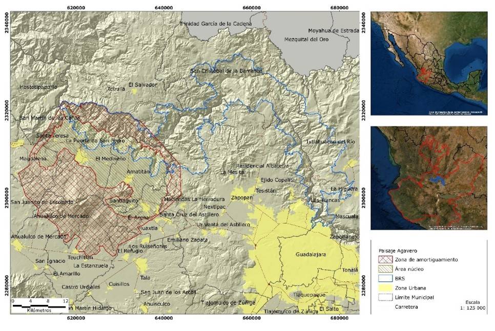
The Ravine of the Santiago River (RSR) is located in western Mexico, in the ecoregion of the western canyons, where warm subhumid climate and warm dry forests coincide. The selected study area Ravine of the Santiago River (SA-RSR) was a portion of 72 338 ha of the RSR located northwest of the city of Guadalajara between the coordinates: 2292611 and 2333334 north latitude, 683447 and 616155 west longitude, in the limits of the Sierra Madre Occidental and the Transversal Neo Volcanic Axis, territories of the following municipalities are included: Guadalajara, Zapopan, Ixtlahuacán del Río, San Cristóbal de la Barranca, Amatitán and Tequila. Twenty-one percent of the 86 639 ha of the Agave Landscape, 7 745.23 ha of the core area and 10 382.2 ha of the buffer zone (Figure 1) were also included.
Distribution of the Agave tequilana crop
The location of the agave cultivation sites in SA-RSR was made based on: (1) a database of georeferenced plots provided by the Tequila Regulatory Council; and (2) several field trips to georeference the cultivated agave plots, which were later digitized to know their location and area through the use of high-resolution satellite images provided from the Google Earth server, the ArcMap v10.3 program was used and all layers were homogenized under the Universal Transverse Mercator (UTM) coordinate system for zone 13 of the northern hemisphere.
Selection and making of layers of the agroecological requirements of A. tequilana
When comparing A. tequilana with other cosmopolitan crops, the literature on the agroecological requirements of A. tequilana is limited; however, substantive information generated in the most traditional cultivation areas (Ruiz-Corral et al., 2002; 2013) and from experiments carried out under controlled conditions in the laboratory, greenhouse or bioclimatic chambers, is found (Nobel et al., 1998, Pimienta-Barrios et al., 2006).
Coinciding with some of the criteria established in similar works (De León et al., 1991; Ruiz-Corral, 2007; Tinoco et al., 2010; Collazo et al., 2011), fifteen environmental variables were selected as predictors of the agroecological conditions in which the cultivar develops within the RSR, of which eleven are climatic, two topographic and two edaphic (Table 1).
Table 1 Variables considered for the agroecological characterization of the ravine of the Santiago River and the crop of Agave tequilana Weber.
| Variable | Origin |
| Climate | Garcia (1998) |
| Average annual minimum temperature | Medina et al. (2016) |
| Average annual temperature | Medina et al. (2016) |
| Average annual maximum temperature | Medina et al. (2016) |
| Average annual diurnal temperature | Generated |
| Average annual nocturnal temperature | Generated |
| Annual thermal oscillation | Generated |
| Annual accumulated rainfall | Medina et al. (2016) |
| Available moisture - wet months | Generated |
| Annual accumulated potential evapotranspiration | Medina et al. (2016) |
| Photoperiod | Medina et al. (2016) |
| Altitude | Generated |
| Slope | Generated |
| Type of soil | INEGI (1982) |
| Soil texture | Sánchez et al. (2018) |
We use the layers of the existing climatic cartography for the Mexican continental territory with reference period from 1961 to 2010, in raster format and projection in WGS84 geographic coordinates, with a resolution of 30 arcseconds (Medina-García et al., 2016). The layers of the twelve months of the year of minimum temperature, average temperature, maximum temperature, rainfall, evapotranspiration and photoperiod, which were transformed from RST format to TIFF with a resolution of 151 m. Independently, the following layers were generated: average annual temperatures and photoperiod (arithmetic mean of the values of the twelve months of the year), as well as the layers of accumulated rainfall and evapotranspiration (sum of the twelve months of the year).
The average annual diurnal temperature and the corresponding nocturnal temperature were calculated based on the values of the twelve months of the year according to the procedure suggested by Tinoco et al. (2010); Collazo et al. (2011). The annual thermal oscillation was calculated using the formula suggested by WorldClim for the generation of the BIO7 variable (Fick and Hijmans, 2017). The moisture available in the soil (when rainfall is greater than potential evapotranspiration) was calculated for the twelve months of the year and a layer of the wettest season of the year (June-September) was generated. After the corresponding portion of the SA-RSR of each of the variables was extracted, these layers were reprojected to the UTM Z13N WGS84 coordinate reference system in order to calculate values of area in metric units.
The climate chart in raster format, at a scale of 1:1 000 000 generated by García (1998) available in the national biodiversity information system (SNIB, for its acronym in Spanish) was used. The topographic variables were created based on the digital elevation model of INEGI (2022) with a resolution of 30 m pixel size, from which the RSR cover was extracted to make the altitude and slope layers, which were subsequently vectorized. The types of soil were obtained from the soil charts in PDF format at a scale of 1:50 000 (INEGI, 1982), from which the area corresponding to the SA-RSR was digitized. The layer of soil texture was extracted from the vector information developed by Sánchez et al. (2018). Finally, categories were defined for each variable according to their range of values and areas were calculated both for the study area and for each of the farms cultivated with A. tequilana.
Results
Distribution of the Agave tequilana crop
The cultivation of A. tequilana within the SA-RSR is determined, in part, by the accessibility to the plot to perform the different tasks required by the crop and to carry out the transport of the mezcal heads to the factories. The topography limits the development of productive activities in most of the ravine. Within the SA-RSR (72 338 ha), a total of 1 017.58 ha cultivated with A. tequilana was determined, located mainly to the west, in the municipalities of Tequila and Amatitán. This area is part of the area of origin of the crop, recognized as The Agave Landscape and the Ancient Industrial Facilities of Tequila. The location of the plots cultivated with A. tequilana in the SA-RSR is shown in the following figures.
Agroclimatic characterization
The predominant climate (in the 72.39%) in the SA-RSR is the warm subhumid Awo. The climates of the semi-warm subhumid type (A)C(wo) and (A)C(w1) are present in the rest of the ravine with 14.96% and 12.51% of its area, respectively, along with a minimum portion of temperate climate C(wo) with 0.14% (Figure 2A). Of the 1 017.58 ha that are planted with agave in the study area, 97.95% are under the regime of warm climate (Awo).
The ravine is a frost-free zone, the values of average minimum temperature in most of the ravine (89.2%) range between 12 and 16 °C, the lowest range (from 9 to 11 °C) occurs in a small part of the area (10.8%) on the border with the mountains (Figure 2B). Seventy-eight percent of the cultivated agave area was in places where the minimum temperature is between 14 and 16 °C. Twenty percent of the cultivated area is in the range of 12 to 13 °C and only 2% of this area has the lowest minimum temperatures, which can reach 9 °C. The values of average annual temperature vary inside the ravine between 17 and 25 °C, in 86.5% this temperature was observed in the range between 21 and 25 °C, in the rest of the area (13.5%) it remains between 17 and 20 °C (Figure 2C).
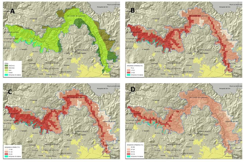
Figure 2 Distribution of variables in SA-RSR and cultivated plots of A. tequilana: A) type of climate; B) average annual minimum temperature; C) average annual temperature; and D) average annual maximum temperature.
Most of the cultivated agave (84%) is in the highest range of average annual temperature (23-25 °C), 14% was observed in the range of 21-22 °C and only 2% is in the zone with the range of 17-20 °C. The annual maximum temperatures in the SA-RSR vary from 24 to 34 °C, although 91% of its area (Figure 2D) was in the intermediate range between 27 and 32 °C, in 9% of the remaining area either the lowest extreme values (24 °C) or the highest (34 °C) occur. Eighty-nine percent of the agave crop in the RSR is in the maximum temperature range of 30 to 32 °C, 5% was in the range of 27 to 29 °C and only 6% in the range of 33 to 34 °C.
The average annual diurnal temperature calculated for the SA-RSR (Figure 3A) is between 27 and 30 °C, in 57% of its area, while 40% of it was in the range of 24-26 °C, covering the lowest range (21 to 23 °C), 3% of the area of the ravine. Almost all (91%) of the area planted with agave in the SA-RSR was in the range of 27-30 °C of average annual diurnal temperature, only 9% is in the range of 24-26 °C. On the other hand, the values of average annual nocturnal temperature inside the SA-RSR (Figure 3B) show little variation, 70% of its area is between 16 and 18 °C and in 23% of it the highest nocturnal temperatures are between 19 and 20 °C, the coolest temperatures are between 13 and 15 °C and only occur in 7% of the ravine.
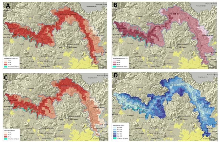
Figure 3 Distribution of variables in SA-RSR and cultivated plots of A. tequilana: A) average annual diurnal temperature; B) average annual nocturnal temperature; C) annual thermal oscillation; and D) annual accumulated rainfall.
The largest area cultivated with agave within the ravine (58%) has the highest nocturnal temperatures in the SA-RSR, between 19 and 20 °C, followed by 41% of the area with records between 16 and 18 degrees. The values of annual thermal oscillation that occur in the RSR (Figure 3C) are between 22 and 27 °C. In 51% of the area of the SA-RSR, the annual temperature ranges between 24 and 25 °C, as for the areas cultivated with A. tequilana, 68% of it is in the range of 26-27 °C of annual thermal oscillation, while 31% is in the range of 24-25 °C.
The accumulated rainfall inside the SA-RSR (Figure 3D) shows lower rainfall in the deep parts of the ravine (71% of its area) with values between 822 and 900 mm per year; while in the periphery of this, in areas of higher altitude, the highest values are obtained, without exceeding 965 mm of annual rainfall. Seventy percent of the farms cultivated with agave are in the rainfall range of 857 to 900 mm, below this range (822 to 856 mm) is 12% of the area, while above it (901 to 965 mm) was 18% of the agave area in the SA-RSR.
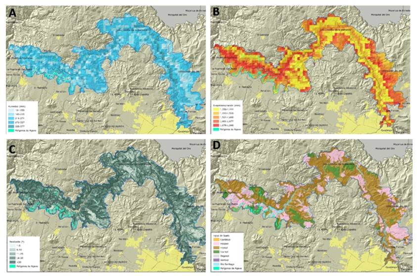
The available moisture (Figure 4A) occurs during most of the rainy season (June to September, 122 days), when rainfall values are higher than those of evapotranspiration. The range of available moisture, 92% of the RSR area was observed between 160 and 327 mm, in this same range was 98% of the farms cultivated with agave in the SA-RSR. The SA-RSR presents values of accumulated potential evapotranspiration (ETo) between 1 350 and 1 849 mm (Figure 4B), well above the values of rainfall (between 822 and 965 mm). In general terms, it is observed that the highest values, between 1 678 and 1 849 mm, occur in the last third downstream of the riverbed, which represented 13.4% of the SA-RSR. Most of the area cultivated with agave (70%) is between 1 445 and 1 600 mm ETo, 12% of it is in the lowest range of 1 350 to 1 444 mm, while in the highest values of ETo ranging from 1 601 to 1 849 mm was 18% of the cultivated area. In the SA-RSR, the annual average photoperiod is 12 h, with fluctuations of less than two hours throughout the year.
Edaphic and physiographic variables
The altitude of the study area varies between 637 and 2 146 masl. Forty-seven percent of the agave plantations are distributed between 637-933 masl, 35% between 934-1 136 masl and 10% between 1 137-1 350 masl; the remaining 8% is distributed between 1 351-2 146 masl. Given the topographic configuration of the SA-RSR, its area has slopes ranging from 1 to 10°, 21% of its area (Figure 4C), which houses 48% of the farms cultivated with A. tequilana. Twenty-six percent of the SA-RSR has slopes of 11 to 20° in which is 33% of the area cultivated with agave. The slopes of more than 20° are present in 53%, where 19% of the agave is planted.
Three types of soil predominate in the SA-RSR, which together cover 97.3% of the SA-RSR, Figure 4D, the most abundant is Lithosol (57.5%), which covers the steep slopes on the banks of the river, they are thin soils less than 10 cm deep, followed by Phaeozem soils (28.5%), which have a dark surface layer rich in organic matter and nutrients, and Luvisol-type soils (11.3%), which are soils with accumulation of clay and high susceptibility to erosion, red or yellowish, the least represented soils are Cambisol, Regosol and Vertisol, which together account for only 2.7% of the area of the SA-RSR. The agave crop in the RSR is established in a similar proportion, 42% in the Phaeozem and Luvisol soils and 16% in the Lithosol-type soil.
Ninety percent of the soil of the RSR has a medium texture, with the presence of some areas (8.4%) of fine texture, located mainly east of the study area and a minimum portion (1.6%) of soil with coarse texture, 97% of the area cultivated with agave is in soils with medium texture, the rest is in soils of fine texture in the limits of the ravine with the valley.
Discussions
Distribution of the crop
The planting of A. tequilana has expanded greatly in and out of the area of appellation of origin of tequila. In 2019 the state of Jalisco contributed 74% to the more than one million 513 thousand tonnes harvested (SIAP, 2020a) and the Valles region that includes the SA-RSR produces between 18 and 25% of state production (SIAP, 2020b), the 1 018 ha reported in this work correspond to the first record of area cultivated with agave in the SA-RSR, of which 96% are within the territory of the Agave Landscape.
Climate variables
The A. tequilana plant adapts to semiarid and subhumid subtropical climates with temperate, semi-warm or warm thermal regime (Ruiz-Corral, 2007). Ideal climates are considered to be those that have a temperate to semi-warm thermal regime (Ruiz-Corral et al., 2002; Valenzuela, 2003; Ruiz et al., 2013). The predominant climate in the SA-RSR is warm subhumid, where warm temperatures throughout the year increase plant respiration and consumption of carbohydrates produced during the photosynthetic process (Ruiz-Corral et al., 2002; Pimienta-Barrios et al., 2006), which is why SA-RSR is considered a marginal area for 97.95% of the A. tequilana crop.
The temperature inside the SA-RSR depends in part on: (1) the depth of the ravine (500 m in general); (2) the area of influence of the riverbed and the Santa Rosa Dam; and (3) the slope of the riverbed, 1 000 masl at the beginning and 570 masl at the end. The minimum temperature in most (89%) of the SA-RSR is greater than 12 °C so frosts that could be a limitation for the establishment of crops do not occur (Pimienta-Barrios et al., 2006). The average temperature is between 23 and 25 °C and is favorable for 84% of the area planted with agave, since for the agave-growing areas of the state of Jalisco 30 °C is considered as the optimal average temperature (Valenzuela, 2003).
The maximum temperatures in the regions cultivated with agave range between 30-34 °C (Valenzuela, 2003), the extremely warm environments reduce photosynthesis due to increased respiration (Pimienta et al., 2006), this range was present in 95% of the farms with agave in the SA-RSR. The nocturnal temperature values presented by 60% of the area cultivated with agave in the SA-RSR are 19-20 °C, they could be a disadvantage compared to the remaining 40%, which register slightly cooler nocturnal temperatures (16-18 °C), which would facilitate the assimilation of CO2 in the summer, according to the optimal nocturnal temperature estimated between 11 and 21 °C by Ruiz-Corral (2007).
The thermal oscillation throughout the year inside the SA-RSR can vary from 22 to 27 °C, which does not represent an inconvenience for the cultivation of agave, since the difference between the maximum and minimum temperatures occurs within the thermal range of the dominant warm climate in the area. The A. tequilana plant adapts to conditions of extreme aridity (Pimienta et al., 2006); however, a rainfall of less than 500 mm produces poor quality harvests and rainfall greater than 1 000 mm requires well-drained soils (Valenzuela, 2003).
In the SA-RSR, rainfall varies between 822 and 965 mm, it is within the average (600 to 1 200 mm per year) that occurs in the producing areas (Valenzuela, 2003; Ruiz-Corral et al., 2013), so there is adequate rainfall for the development of the crop. The determined available moisture values (from 160 to 327 mm) allow the plant to store water in its tissues for use in the dry season. The evapotranspiration values obtained for the SA-RSR are represented on the map in small portions of a few square kilometers, a situation caused by the environment of the dam and the river, but also by the orographic heterogeneity and the level of human intervention in the ravine.
Being a plant that prefers sunny days, the duration of the photoperiod in the agave-growing areas is between 10.5 and 13.6 h. The SA-RSR extends longitudinally so its photoperiod is 12 ±2 h. According to the field work carried out, it is evident that in most of the farms the presence of any other stratum or type of vegetation that shades the crop is avoided.
Physiographic and edaphic variables
Although A. tequilana adapts to a wide altitudinal range, it is favored by the range from 1 000 to 2 200-2 400 masl (Ruiz-Corral et al., 2013), which is why most of the agave grown in the RSR may not be storing high amounts of sugar because it is located below 1 000 masl (Pimienta et al., 2006). The slope of the land determines the potential to establish plantations of A. tequilana. The optimal slopes for cultivation range from 2 to 8% (5° approximately), which facilitates cultivation work and avoids stagnations, on the contrary, slopes greater than 45% (24°, 23°) are considered marginal for the establishment of the crop (Ruiz-Corral, 2007), some farmers prefer to cultivate the slopes of the hills (above 20°) because excess moisture is better drained.
A. tequilana develops in thin or deep soils with medium texture (loam, loam-sandy or loam-clayey soils), they also develop adequately in thin or deep soils (Ruiz-Corral, 2007; Ruiz-Corral et al., 2013), in the state of Jalisco, agave is cultivated in Luvisol, Cambisols and Lithosols soils, which have an ochre to reddish color (INEGI, 2014). In the SA-RSR about 82% of the area with agave is in the Phaeozem and Luvisol soils. Although in areas with low rainfall, agaves prefer soils of heavy texture (clayey or silt-clayey) that have greater moisture retention (Ruiz-Corral, 2007). The soils of the SA-RSR, in general, have medium texture, which is why almost all the cultivated farms (97%) present this condition.
Conclusions
Coinciding with the research carried out by different authors who have determined that temperature is the determining factor for the development of the A. tequilana crop and according to this research, the ravines where the cultivar and its industry originated are considered marginal regions for its cultivation, due to the warm temperatures that prevail throughout the year, which reduce net photosynthesis due to increased respiration.
In practice, farmers sustain the natural condition that the SA-RSR presents, they consider it an area suitable for the production of agave, since it lacks temperate lands, which allows the agave to have a rapid growth and despite having the disadvantage of storing less reducing sugar, this does not significantly reduce its percentage per kilo of agave. Finally, and following the laws of the market, it is not bad to produce agave in the SA-RSR. The main problem not only for the cultivation of A. tequilana but for the development of any productive activity is its orography due to the predominance of rugged terrain and steep slopes.
Although the management plan of The Agave Landscape and the Ancient Industrial Facilities of Tequila as Cultural Heritage of Humanity includes actions for the preservation of the natural environment of the ravine of the Santiago River, such as ‘conserving and protecting the characteristics of the natural physical environment and rural heritage with a sustainable vision’, the cultivation of A. tequilana represents one of the main causes of environmental degradation in the SA-RSR. The results of this work can contribute to reorient the current industrial cultivation system of A. tequilana to a regenerative and sustainable planting system, as well as to the fulfillment of the objectives of the management plan of the Agave Landscape.
Acknowledgements
To the peasants of the ravine who gave us the facilitations for the development of field work.
REFERENCES
Alcaraz, A. F. J. 2011. Geobotánica, manual de prácticas. Universidad de Murcia, España. http://www.um.es/docencia/geobotanica/ficheros/tema01.pdf. [ Links ]
Collazo, J. A.; Báez, M.; González, J.; Ramos, M. y Torres, J. R. 2011 Caracterización Agroclimática del Estado de Aguascalientes. Instituto de Investigaciones Forestales, Agrícolas y Pecuarias (INIFAP). Centro de Investigación Regional Pacífico Centro. México. [ Links ]
CRT. 2021. Consejo Regulador del Tequila. Estadísticas 2020. https://www.crt.org.mx/EstadisticasCRTweb/. [ Links ]
De León, L. L. A.; Arriba, B. A. y Plaza, M. C. 1991. Caracterización agroclimática de la provincia de Cáceres. España: Ministerio de Agricultura Pesca y Alimentación. http://www.mapama.gob.es/ministerio/pags/Biblioteca/fondo/pdf/2871-all.pdf. [ Links ]
Fick, S. E. and Hijmans, R. J. 2017. WorldClim 2: new 1-km spatial resolution climate surfaces for global land areas. Inter. J. Climatol. 37(12):4302-4315. [ Links ]
García, E. 1998. Comisión nacional para el conocimiento y uso de la biodiversidad. Comisión Nacional para el Conocimiento y Uso de la Biodiversidad (CONABIO). Clasificación climática de Köppen, modificado por García. Escala 1:1000000. DF, México. [ Links ]
Gentry, H. S. 1982. Agaves of continental North America. University of Arizona Press. Tucson Arizona. [ Links ]
Gutiérrez, L. M. P. 2007. Fuentes documentales para el estudio del vino mezcal en los archivos de Jalisco. Siglos XVIII y XIX. In: Sánchez, S. E. (Coord.). Cruda realidad-producción, consumo y fiscalidad de las bebidas alcohólicas en México y América Latina. Instituto de Investigaciones. México, DF. 43-69 pp. [ Links ]
INEGI. 1982. Instituto Nacional de Estadística, Geografía e Informática. Cartas Edafológicas digitalizadas: F13D45, F13D54, F13D55, F13D56, escala 1:50000. [ Links ]
INEGI. 2014. Instituto Nacional de Estadística, Geografía e Informática. Guía para la interpretación de cartografía edafología escala 1:250000 Serie III. México. 60 p. [ Links ]
INEGI. 2022. Instituto Nacional de Estadística, Geografía e Informática. Continúo de elevaciones mexicano 3.0 para el Estado de Jalisco. https://www.inegi.org.mx/app/geo2/elevacionesmex/. [ Links ]
Jiménez, V. M. C. 2008. El origen y desarrollo de la agroindustria del vino mezcal tequila. Benemérita Sociedad de Geografía y Estadística del estado de Jalisco. 35 p. [ Links ]
Medina-García, G.; Ruiz-Corral, J. A.; Rodríguez-Moreno, V. M.; Soria-Ruiz, J.; Díaz-Padilla, G. y Zarazúa, V. P. 2016. Efecto del cambio climático en el potencial productivo del frijol en México. Rev. Mex. Cienc. Agríc. 13:2465-2474. [ Links ]
Muriá, J. M. 2016. El famoso tequila. Ed. Porrúa. DF, México. 160 p. [ Links ]
Nobel, P. M.; Castañeda, G.; North, E. y Ruíz, C. J. 1998. Temperature influences on leaf CO2 exchange, cell viability and cultivation range for Agave tequilana. J. Arid Environ. 39:1-9. [ Links ]
Padilla, L. 2017. Calidad de vida de los jornaleros del agave en el municipio de Tequila, Jalisco. Tesis de Maestría en Estudios Socioterritoriales, Universidad de Guadalajara. [ Links ]
Pérez, L. 1887. Estudio sobre el maguey llamado mezcal en el estado de Jalisco. Boletín de la Sociedad Agrícola Mexicana. Imprenta Ancira. DF, México. 22 p. [ Links ]
Pimienta-Barrios, E.; Zañudo-Hernández, J.; García, J. y Nobel, P. 2006. Ecofisiología del agave azul. Universidad de Guadalajara. [ Links ]
Ruíz-Corral, J. 2007. Requerimientos agroecológicos y potencial productivo del agave Agave tequilana Weber en México. Ed. Conocimiento y prácticas agronómicas para la producción de Agave tequilana Weber en la zona de denominación de origen del tequila. Instituto Nacional de Investigaciones Forestales, Agrícolas y Pecuarias (INIFAP). Centro de Investigación Regional del Pacífico Centro. 11-36 pp. [ Links ]
Ruíz-Corral, J.; Medina, G.; González, I.; Flores, H.; Ramírez, G.; Ortiz, C.; Byerly, K.; y Martínez, R. 2013. Requerimientos agroecológicos de cultivos. 2da . Ed. Instituto Nacional de Investigaciones Forestales, Agrícolas y Pecuarias (INIFAP). México, DF. [ Links ]
Ruíz-Corral, J.; Pimienta-Barrios, E. y Zañudo-Hernández, J. 2002. Regiones térmicas óptimas y marginales para el cultivo de Agave tequilana en el estado de Jalisco. Agrociencia. 36:41-53. [ Links ]
Sánchez, J.; Ruíz, C. J.; Medina, G.; Ramírez, G.; De la Cruz, L.; Brendan, J.; Miranda, R. y García, G. 2018. Ecogeography of teosinte. PLoS One. 13(2):e0192676. https://doi.org/10.1371/journal.pone.0192676. [ Links ]
SIAP. 2020a. Servicio de Información Agroalimentaria y Pesquera. Panorama Agroalimentario. México. 196 p. [ Links ]
SIAP. 2020b. Servicio de Información Agroalimentaria y Pesquera. Estadística de cierre agrícola a nivel municipal. https://www.gob.mx/siap. [ Links ]
Suárez, A. 2014. Percepciones y discursos culturales en torno al paisaje agavero. Universidad de Guadalajara. [ Links ]
Tena, M.; Ávila, R. and Navarro, C. R. 2018. Tequila, heritage and tourism: is the Agave landscape sustainable? In: Medina, X. y Tresserras. Ed. Food, gastronomy and tourism. social and cultural perspectives. Colección estudios del hombre. [ Links ]
Tinoco, C.; Báez, A.; Ruiz, C. J. A. y Medina, G. 2010. Caracterización climática y edáfica del área de abastecimiento del Ingenio El Modelo, Veracruz. Instituto de Investigaciones Forestales, Agrícolas y Pecuarias (INIFAP). DF, México. [ Links ]
UNESCO. 2006. World heritage list. Agave landscape and ancient industrial facilities of tequila world heritage convention. http://whc.unesco.org/en/list/1209. [ Links ]
Valenzuela, Z. A. G. 1997. El agave tequilero, su cultivo e industria. Ed. Ágata. Guadalajara, México, DF. 119 p. [ Links ]
Valenzuela, Z. A. G. 2003. El agave tequilero, cultivo e industria de México. Mundi Prensa. DF, México. 215 p. [ Links ]
Received: March 01, 2023; Accepted: May 01, 2023
 Este es un artículo publicado en acceso abierto bajo una licencia Creative Commons
