


Services on Demand
Journal
Article
 text in
  English (pdf)
 Article in xml format
 Article references
 Send this article by e-mail
Indicators
-
 Cited by SciELO
 -
 Access statistics
Related links
-
 Similars in
SciELO
Similars in
SciELO
Share

 Permalink
Revista mexicana de ciencias agrícolas
Print version ISSN 2007-0934
Rev. Mex. Cienc. Agríc vol.11 n.6 Texcoco Aug./Sep. 2020 Epub Oct 11, 2021
https://doi.org/10.29312/remexca.v11i6.2611
Articles
Adaptability analysis of Leucaena collinsii in the microbasin Tula, Mexico
1Maestría en Agroforestería para el Desarrollo Sostenible-Departamento de Suelos-Universidad Autónoma Chapingo. Carretera México-Texcoco km 38.5, Texcoco, Estado de México. CP. 56230. (damian.326@hotmail.com; zamora.elizalde.231195@gmail.com).
2Posgrado en Edafología-Colegio de Postgraduados. Carretera México-Texcoco km 36.5, Texcoco, Estado de México. CP. 56230. (idiaz@ualberta.ca).
3 Ingeniería en Recursos Naturales Renovables-Departamento de Suelos-Universidad Autónoma Chapingo. (arturomgarcia09@gmail.com).
4Posgrado en Producción Animal-Departamento de Zootecnia-Universidad Autónoma Chapingo. (arturomrtz@hotmail.com).
In recent decades, the deterioration of natural resources in Mexico has increased due to changes in land use and increasing urbanization in areas of high ecological vulnerability and low levels of productivity. The Tula micro-basin, Mexico is located in a semi-dry climate zone where soil degradation and population increase are having a strong impact on soil conservation. The objective of this study was to determine the areas suitable for the optimal development of the Leucaena collinsii Britton & Rose species in the Tula microbasin, through the maximum entropy ecological niche model, MaxEnt, for soil rehabilitation purposes. For the modeling, 19 environmental variables and 8 presence records were used, obtained from the GBIF and MEXU databases. The modeling results indicated that the variables with the greatest contribution were temperature and evapotranspiration, and that the model has a good predictive capacity (p-value= 0.013), according to the significance test with a level α= 0.05, based on the Jackniffie technique. In the model, the potential distribution of the species was low, with just 8% of the surface of the micro-basin, but a high survival (100%) was recorded, in the experimental validation. It was concluded that there are few adaptability zones for the species, in the Tula microbasin; however, its high survival in the experimental plot, determined that its introduction is an option for soil rehabilitation.
Keywords: ecological niche modeling; potential distribution; rehabilitation; soil degradation; survival
En las últimas décadas, el deterioro de los recursos naturales en México se ha incrementado debido a los cambios del uso del suelo y a la urbanización creciente en áreas de alta vulnerabilidad ecológica y bajos niveles de productividad. La microcuenca Tula, México está ubicada en una zona de clima semiseco donde la degradación del suelo y el incremento de la población están ejerciendo un fuerte impacto en la conservación del suelo. El objetivo de este estudio fue determinar las zonas aptas para el desarrollo óptimo de la especie Leucaena collinsii Britton & Rose en la microcuenca Tula, a través del modelo de nicho ecológico de máxima entropía, MaxEnt, con fines de rehabilitación del suelo. Para el modelado, se utilizaron 19 variables ambientales y 8 registros de presencia, obtenidas de las bases de datos GBIF y MEXU. Los resultados de la modelación indicaron que las variables con mayor contribución fueron la temperatura y la evapotranspiración, y el modelo tiene buena capacidad de predicción (p-valor= 0.013), de acuerdo con la prueba de significancia con α= 0.05, basada en la técnica de Jackniffie. En el modelo, la distribución potencial de la especie fue baja, con apenas 8% de la superficie de la microcuenca, pero se registró una alta sobrevivencia (100%), en la validación experimental. Se concluyó que existen escasas zonas de adaptabilidad para la especie, en la microcuenca Tula; sin embargo, su alta sobrevivencia en la parcela experimental determinó que su introducción es una opción para la rehabilitación del suelo.
Palabras clave: distribución potencial; degradación del suelo; modelado de nicho ecológico; sobrevivencia; rehabilitación
Introduction
In recent decades, the deterioration of natural resources in Mexico has been increasing, which in many cases is irreversible. Current rates of land use change have underestimated the damage that agricultural and forestry technologies and activities produce to natural resources. In addition to the above, the urbanization process as a growing trend in areas of high ecological vulnerability and low levels of productivity, such as areas with dry and semi-dry climates, and shallow soils in hills and with steep slopes.
The Tula micro-basin, Mexico is located in an area where two different types of climates converge: temperate sub-humid and semi-dry (INEGI, 2017a). However, in the semi-dry climate area is where soil degradation is a common characteristic and where the population of the 14 municipalities that comprise it has increased by an average of 2% per year, reaching a total of 288 196 inhabitants in the year 2010 (INEGI, 2013a).
This increase in population has caused greater pressure on the region's natural resources, in addition to problems associated with land use change (Zamora et al., 2020). Also, the areas for the extraction of construction materials, agricultural areas and urban spots have increased (INEGI, 2017a, 2017b, 2017c), causing greater soil degradation due to the loss of vegetation cover.
Consequently, the need arises to seek alternatives for soil rehabilitation, recovery and conservation in areas that have lost their productivity, in addition to agronomic or vegetative practices (Zavala-Cruz et al., 2011). An alternative is the introduction of multiple-use plants (forage production, vegetation cover and soil conservation), which have an optimal development in the region.
The Leucaena collinsii Britton & Rose species is distributed from southern Mexico to Guatemala and belongs to the Fabaceae family (Zárate-Pedroche, 1998). In Mexico, it is used as fodder (due to its low tannin and mimosine content and high regrowth capacity), in reforestation for erosion control, as a shade tree and nitrogen fixer (Zárate-Pedroche, 1998; Mullen et al., 2003; Wencomo and Ortiz, 2010; Pinto et al., 2013).
Its main characteristics include its remarkable tolerance to water stress due to its pivoting root system that allows it to reach moisture in the deep layers of the soil, resistance to psyllid (phytophagous insect, Heteropsylla cubana) which are one of the main pests of its genus and its adaptation in a wide variety of soils, from neutral to alkaline (Hernández et al., 1987; Zárate-Pedroche, 1998; Martínez-Hernández et al., 2019).
However, to date, there have been no attempts to determine its potential geographical distribution at fine scales, despite the fact that it is a kind of cosmopolitan distribution and that it can be introduced in areas with low rainfall. Therefore, knowing the distribution of this species would help determine the areas in which it is convenient to introduce it for soil rehabilitation purposes.
On the other hand, the distribution of species is governed by several factors, the most important of which are environmental, since their survival and development is determined by a range of environmental conditions, which are the indicators to determine their respective ecological niche, among other factors (López, 2007; Peterson et al., 2008; Soberon and Nakamura, 2009).
In recent years, more than 15 algorithms have been developed to model ecological niches of species and to obtain their potential distribution (Elith et al., 2006), these algorithms are based on the concept of ecological niche established by Hutchinson (1957), who relates biological information to environmental information, to determine areas where there are no records of the presence of a species but that meet the appropriate conditions for the survival and development of the species (Soberon and Peterson, 2005; López, 2007; Elith et al., 2010).
MaxEnt is an algorithm for making predictions of geographic distributions of species (Phillips et al., 2006) and is considered one of the best algorithms for modeling ecological niches (Contreras-Medina et al., 2010; Elith et al., 2010), to determine the relationship between environmental variables and the presence records of a species (Broennimann et al., 2007; Palma-Ordaz and Delgadillo-Rodríguez, 2014).
It is an artificial intelligence method that estimates the probability of occurrence of the species by looking for the maximum entropy distribution (as uniform as possible) subject to the condition that the expected value of each environmental variable according to this distribution coincides with its empirical mean (López, 2007; Flores-Maldonado, 2014).
The result of the model expresses the habitat suitability value for the species as a function of the environmental variables (Phillips et al., 2006). A high value of the distribution function in a given cell indicates that it presents very favorable conditions for the presence of the species (Lopez, 2007; Flores-Maldonado, 2014).
Ecological niches modeling with MaxEnt has been used in several studies, among which are those of Peralta et al. (2013) with Quercus rotundifolia;Cruz-Cárdenas et al. (2014) with Liquidambar styraciflua L., Quercus rubramenta Trel. and Roldana robinsoniana (Greenm.) H. Rob. & Brettell.; Quesada-Quiros et al. (2016) with Comarostaphylis arbutoides (Lindl.), Ilex pallida (Standl.), Myrrhidendron donnellsmithii (J. M. Coult. & Rose), Quercus costaricensis (Liebm.) and Vaccinium consanguineum (Klotzsch) and Reynoso et al. (2018) with Pinus pseudostrobus Lindl. and Pinus oocarpa Schiede ex Schltdl.
From the previous studies it was shown that the modeling of ecological niches facilitated the understanding of the potential distribution patterns of a species and the areas of greatest environmental suitability for its establishment and development. Therefore, the objective of this work is to determine the suitable areas of potential distribution for the optimal development of the Leucaena collinsii Britton & Rose species in the Tula microbasin; through the maximum entropy ecological niche model, MaxEnt, for soil rehabilitation purposes.
Materials and methods
Location of area of study
The Tula microbasin is located at the geographical coordinates of 19° 55’ 31.05’’ and 19° 34’ 28.74’’ north latitude and 98° 39’ 59’’ and 98° 28’ 16.39’’ west latitude, with a surface area of 1 037.66 km2 (103 766 hectares) and covers three states of the Mexican Republic: the State of Mexico, Hidalgo and Tlaxcala. It is immersed in the hydrological region 26.
Panuco river basin and belongs to the physiographic province of the Neovolcanic axis, with an altitudinal range that varies between 2 333 to 3 223 masl. The types of climate are temperate sub-humid with rains in summer and temperate semi-dry, the average annual precipitation is 600 mm, with an average annual temperature of 14 °C and the predominant soil is the hyphalic pheozem covering 65% and lithosol with 20% of the surface in the micro-basin (INEGI, 2017a, 2017b, 2017c). It presents various types of vegetation: tuscan forest, pine forest, oak forest and crasicaule scrub (INEGI, 2017d).
Presence data
The records for the presence of the L. collinsii species, obtained from the World Biodiversity Information Infrastructure (GBIF) database and from the National Herbarium of Mexico (MEXU), were refined in order to eliminate those records located outside the national territory limits, duplicate data and those that presented inconsistencies, or in their case, without geographic coordinates as indicated by Martínez-Méndez et al. (2016).
Environmental predictive variables
Data on 19 climatic, seasonal, soil properties, topographic attributes, and normalized vegetation indices were collected and processed for modeling, maintaining quality control as indicated by Hijmans et al. (2005).
5 climatic variables were generated (BIO1, BIO3, BIO4, BIO12 and BIO15, see Table 1) obtained from data from the WorlClim Version 1.4 platform (http://www.worldclim.org/) and derived from the monthly maximum temperature values, minimum temperature and precipitation, which represent the conditions of a time period from 1959 to 2000.
Table 1 Environmental predictive variables used in MaxEnt to generate the ecological niche model of Leucaena collinsii in the Tula microbasin, Mexico.
| A) climatic variables | ||
| BIO1 | = | Average annual temperature |
| BIO3 | = | Isothermally (BIO1/BIO7)*100 |
| BIO4 | = | Seasonal temperature (standard deviation*100) |
| BIO12 | = | Annual precipitation |
| BIO15 | = | Seasonal rainfall |
| B) seasonal variables | ||
| ETRA | = | Annual real evapotranspiration |
| ETRH | = | Real evapotranspiration in wet months |
| ETRS | = | Real evapotranspiration dry months |
| PPH | = | Wet months precipitation |
| PPS | = | Precipitation dry months |
| TH | = | Humid months temperature |
| TS | = | Dry months temperature |
| C) soil properties | ||
| EC | = | Electric conductivity |
| OM | = | Organic material |
| pH | = | Hydrogen potential |
| D) topographical attributes | ||
| ASP | = | Ground orientation |
| ELEV | = | Elevation |
| E) normalized vegetation index | ||
| INVH | = | Normalized index of wet month vegetation |
| INVs | = | Normalized index of dry month vegetation |
The actual annual evapotranspiration (ETRA) was calculated based on the Turc model (1954): ETRA= P / [0.9 + (P/L)2] ½. Where: P = total annual precipitation (mm); L= 300 + 25T + 0.05T3; T= average annual temperature (°C).
In addition, seven seasonal variables were generated according to what was indicated by Sánchez and Carvacho (2011); from the five previous variables with the Turc model (1954), estimating variables related to evapotranspiration (ETRA, ETRH, ETRS), precipitation (PH, PS) and temperature (TH, TS), corresponding to the wet months (May-October) and dry (November-April) (Table 1).
Three variables of soil properties (OM, EC and pH) were included, according to the recommendations of Cruz-Cárdenas et al. (2014), generated from the soil profile data set 1: 250 000 Series II (INEGI, 2013b) and two topographic attributes: orientation (ASP) and altitude (ELEV), generated from the digital elevation model, with a pixel size of 120 m, which is found at INEGI bases within the Mexican 3.0 elevation continuum (INEGI, 2013c).
Finally, two normalized vegetation indices were calculated, generated from NASA’s MODIS TERRA satellite images (Didan, 2015), in periods of the wet months (INVH August 2019) and in the dry months (INVs January 2019) (Table 1). All layers were homogenized at a pixel size of 1 km2 (0.54 arc minutes).
Ecological niche modeling
The modeling of the potential distribution of the L. collinsii species was performed with the Maxent ver. 3.4.0, which uses the machine learning technique to select the most consistent model based on the information of the available variables (Phillips et al., 2006; Phillips and Dudik, 2008), in addition to generating good predictions even when they are used small samples, less than 10 presence data (Phillips et al., 2006; Pearson et al., 2007).
The 19 layers of the edapho-climatic variables and the presence records of the species were used to generate its potential ecological niche model. In the modeling, the configuration used in the MaxEnt algorithm was the linear-quadratic characteristic, with a regularization multiplier equal to 1, for the models (n= 8), since reduced presence registers do not allow evaluating combinations of complexity, for so a conservative approach was chosen.
The output format chosen for the models was ‘raw’, which was subsequently configured in the MaxEnt algorithm where all the models had the logistics type output format, due to the ease of interpretation in the geographic information system (Phillips and Dudík, 2008).
Model validation
According to Guisan and Zimmermann (2000), the performance of a model is evaluated with a presence dataset independent of the one that has been used, to calibrate the model. However, this is difficult to do using the Area Under the Curve, AUC, when you have limited presence data, less than 20, because the greatest number of these would have to be used in your calibration.
Consequently, a significance test, based on the Jackknife technique, was performed to evaluate the predictive performance of a model with less than 20 presence data by verifying if the proposed models are better than those performed randomly. The method consisted of constructing n separate models with the n clean presence records (n= 8), each with n-1 individuals (n= 8-1= 7) and evaluating the ability of each of them to predict the data excluded from the dataset.
With the record that was excluded for each model, the success or failure of the prediction was verified, if it coincided in the distribution area it took a value of 1 (success), otherwise 0 (failure). The success or failure values for each model, supplemented with their predicted area ratio, were entered into the p-value significance test (Pearson et al., 2007), at a significance level of 0.05. The process was performed in the executable p-value Pearson in the R software (R Development Core Team, 2012).
Regarding the evaluation of environmental variables, this was carried out with the Jackknife test, in order to individually assess the contribution of each of them in the model and identify the variable with the most useful information by itself (Phillips and Dudík, 2008).
Evaluation of the survival of the species in the field
Survival evaluation allows obtaining a quantitative measure of the success of the plantation under the influence of the site environment (Ramírez, 2011) and is defined as the quotient, expressed as a percentage, between the number of plants that survive at the end of the follow-up control, and the number of plants emerged, expressed as a percentage (Ramos-Font et al., 2015).
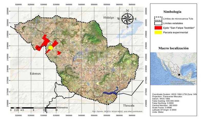
During the years 2018 and 2019, the survival of the species was estimated, in an area with a high degree of soil degradation, in an experimental plot of 1 500 m2 (30 x 50 m wide and long, respectively). The experimental plot was located within the Tula micro-basin (Figure 1) between the geographic coordinates 19° 50’ 24 and 19° 49’ 00’’ north latitude and 98° 42’ 00’’ west longitude, at an altitude of 2 473 masl, in the common of San Felipe Teotitlan, in the municipality of Nopaltepec, bordering the south with the municipality of Axapusco, in the State of Mexico.
During the month of July 2018, 25 three-month-old L. collinsii seedlings were transplanted, randomly distributed in the experimental plot, at six meters between lines and two meters between plants. Survival estimation was made at the establishment stage (three months after transplant), in October 2018 and one year after transplant, in October 2019.
Results and discussion
The final number of L. collinsii presence data, obtained from the MEXU and GBIF database, using the QGIS 2.14.3 software, was 8, after the purification process of 84 records, belonging to the state of Chiapas. The environmental requirements of this species are within the ranges of the environmental variables of the Tula microbasin (Zárate-Pedroche, 1998; Pinto et al., 2013). Regarding the configuration, chosen in the MaxEnt algorithm, this was with the linear-quadratic characteristic and the regularization multiplier equal to 1, for the n= 8 models.
Because small records do not allow evaluating combinations of complexity, a conservative approach was chosen that allowed better performance in the modeling of the species. The output format chosen for the models was ‘raw’. The n= 8 models generated were applied a threshold based on the lowest predicted value” method of habitat suitability based on training records, generating binary models with a value of 1 for the potential distribution areas.
The threshold value was 0.13, which was used to generate the potential distribution map for L. collinsii in the ArcMap 10.5 software, resulting in a Boolean-type map. Regarding the evaluation of model performance, the result of the significance test, based on the Jackknife technique, showed that there are statistically significant differences between the two types of models indicated by the p-value= 0.013, with a level with a significance of 0.05.
This means that the proposed models were better than the randomized models; that is, the former have a good performance or predictive capacity and can serve as a first approximation to identify potential areas of L. collinsii establishment (Pearson et al., 2007).
The final model obtained was with the 8 records as training and the Linear-Quadratic characteristic with a regularization multiplier equal to 1, with an output format of the logistics type, due to the ease of interpretation in the geographic information system (Phillips and Dudík, 2008). The Jackknife test indicated that the environmental variables with the greatest contribution to the model were BIO 4 (Seasonal temperature, °C), with 36% and ETRAH (Real annual evapotranspiration of wet months, mm year-1), with 31% (Figure 2).
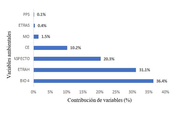
Showing the importance of the precipitation of the wet months (May-October) and of the seasonal temperature in the survival and development of the species (Wencomo and Ortiz, 2010; Pinto et al., 2013; Martínez-Hernández et al., 2019).
Possibly, in places where there is not a shallow depth of soil (variable that was not evaluated) it is favorable for its development in the Tula microbasin. In this regard, Hernández et al. (1987) mention that L. collinsii has a high regrowth capacity, after droughts, due to its pivoting root system that can reach humidity in the deep layers of the soil.
From the modeling of the ecological niche of L. collinsii, it was obtained that due to the environmentl characteristics of the micro-basin, the surface of presence, which is the surface where the species may develop, was 81.9755 km2 (8 197.55 ha), equivalent to 8% of the total surface area, indicating a low distribution with respect to the absence surface of 955.6844 km2 (95 568.44 ha), equivalent to 92% of the total surface (Figure 3).
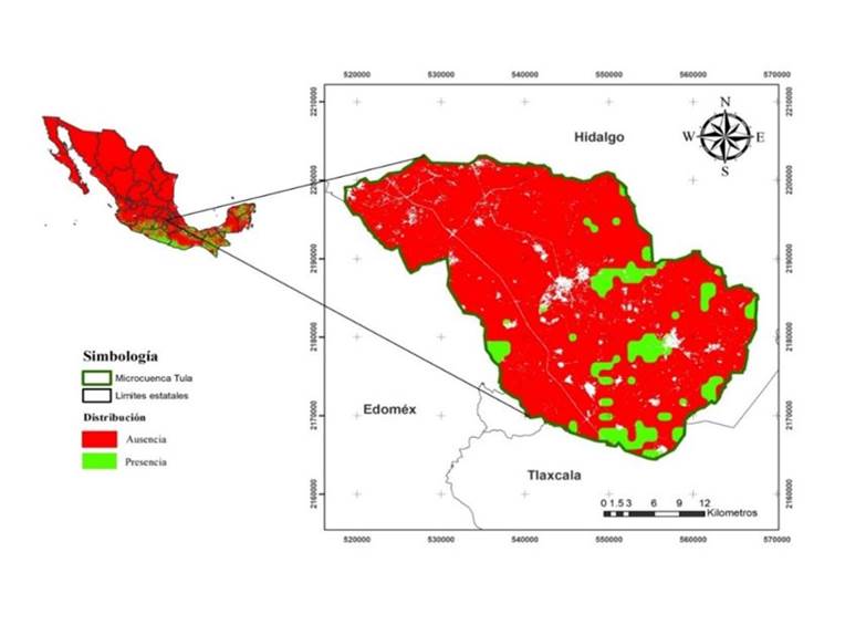
The regions with the best bioclimatic and environmental characteristics to promote their adaptability were the municipalities of Apan, Almoloya, Emiliano Zapata, Tepeapulco and Singuilucan in the state of Hidalgo, Benito Juárez, Calpulalpan and Sanctorum de Lazaro Cardenas in the state of Tlaxcala and the municipality from Axapusco (near the place where the field validation was carried out), in the State of Mexico, since they belong to climatic transition zones of the semi-dry regime, to the sub-humid temperate, where possibly more suitable precipitation and temperature conditions occur for the establishment of L. collinsii.
Regarding the evaluation of the survival of the species in the field, which allows quantifying the success of the plantation under the influence of site factors (Ramirez, 2011), it was 100% (25 individuals), one year after transplanted (October 2019). This coincides with that reported for other species of its genus, such as L. leucocephala, which has been studied in the semi-arid plateu valley of north-central Mexico as part of an agroforestry system forming living wall barriers with nopal (Osuna-Ceja et al., 2019).
The high survival of L. collinsii was possibly due to the fact that it had a high survival (100%) in the establishment stage, management practices and a good distribution of the storm in those years. However, in the cold season it suffered damage, but due to its high regrowth capacity (Hernández et al., 1987), it was able to recover. This means that it is an interesting alternative to be introduced for rehabilitation purposes in the Tula microbasin, because it can increase soil fertility (Crespo, 2008), due to its ability to fix atmospheric nitrogen through symbiosis with Rhizobium and its ability to promote microbial activity (Valpassos et al., 2007),
Pinto et al. (2013) mention that L. collinsii is a species with potential to be used as forage in ruminant feeding systems in the dry tropics of southern Mexico. However, the factors that control their survival in dry climates, with frosts, high altitudes, between 2 300-2 500 m and shallow soils are still unknown. In this study, the ecological niches model showed that for the Tula microbasin its possible distribution is low, but in the field it showed high survival capacity.
Conclusions
Ecological niche modeling with reduced presence data (less than 20) proved to be a reliable tool for determining areas suitable for shrub species for soil rehabilitation purposes. The bush species evaluated L. collinsii depends mainly on the seasonality of temperature (BIO 4) and the real annual evapotranspiration of the humid months (ETRAH), for its potential distribution, which was scarce, with just 8% of the total surface of the Tula microbasin.
However, it registered a high survival in the experimental plot, which makes it possible to introduce it as an option for the rehabilitation of degraded soils, but more studies are needed to determine if survival in the establishment stage is a factor that should be considered for maintain a high survival rate after one year of transplant.
Literatura citada
Broennimann, O.; Treier, U. A.; Müller-Schärer, H.; Thuiller, W.; Peterson, A. T. and Guisan, A. 2007. Evidence of climatic niche shift during biological invasion. Ecology Letters. 8(10):701-709. https://doi.org/10.1111/j.1461-0248.2007.01060.x [ Links ]
Contreras-Medina, R.; Luna-Vega, I. y Ríos-Muñoz, C. A. 2010. Distribución de Taxus globosa (Taxaceae) en México: Modelos ecológicos de nicho, efectos del cambio del uso de suelo y conservación. Rev. Chilena de Historia Natural. 83(3):421-433. https://doi.org/10.4067/ S0716-078X2010000300009. [ Links ]
Crespo, G. 2008. Importancia de los sistemas silvopastoriles para mantener y restaurar la fertilidad del suelo en las regiones tropicales. Rev. Cubana Cienc. Agríc. 4(42):329-335. [ Links ]
Cruz-Cárdenas, G.; López-Mata, L.; Villaseñor, J. L. y Ortiz, E. 2014. Potential species distribution modeling and the use of principal component analysis as predictor variables. Rev. Mex. Biod. 85(1)189-199. https://doi.org/10.7550/rmb.36723. [ Links ]
Didan, K. 2015. MOD13A2 MODIS/Terra Vegetation Indices 16-Day L3 Global 1km SIN Grid V006 [Data set]. NASA EOSDIS Land Processes DAAC. https://doi.org/10.5067/ MODIS/MOD13A2.006. [ Links ]
Elith, J. H.; Graham, C. H.; Anderson, R. P.; Dudík, M.; Ferrier, S.; Guisan, A. and Zimmermann, N. E. 2006. Novel methods improve prediction of species’ distributions from occurrence data. Ecography. 29(2):129-151. https://doi.org/10.1111/j.2006.0906-7590.04596.x. [ Links ]
Elith, J.; Kearney, M. and Phillips, S. 2010. The art of modelling range-shifting species. Methods in Ecology and Evolution. 1(4): 330-342. https://doi.org/10.1111/j.2041-210X.2010.00036.x. [ Links ]
Flores-Maldonado, J. J. 2014. Análisis de los patrones de diversidad de leguminosas arbustivas del río Sabinas, Coahuila, México; bajo el enfoque del modelado de nichos ecológicos. Tesis de Doctor en Ciencias con Acentuación en Manejo de Vida Silvestre y Desarrollo Sustentable. Facultad de Ciencias Biológicas, Universidad Autónoma de Nuevo León. San Nicolás de los Garza, Nuevo León, México. 122 p. [ Links ]
Guisan, A. and Zimmermann, N. E. 2000. Predictive habitat distribution models in ecology. Ecological Modeling. 135(2-3):147-186. https://doi.org/10.1016/S0304-3800(00)00354-9. [ Links ]
Hernández, C. A.; Alfonso, A. y Duquesne, P. 1987. Producción de carne basada en pastos naturales mejorados con leguminosas arbustivas y herbáceas II. Ceba final. Pastos y Forrajes. 1(10):246-252. [ Links ]
Hijmans, R. J.; Cameron, S. E.; Parra, J. L.; Jones, P. G. and Jarvis, A. 2005. Very high resolution interpolated climate surfaces for global land areas. Inter. J. Climatol. 25(15):1965-1978. https://doi.org/10.1002/joc.1276. [ Links ]
Hutchinson, G. E. 1957. Concluding remarks. Cold spring harbor symposia on quantitative biology. 22(2):415-457. [ Links ]
INEGI. 2013a. Instituto Nacional de Estadística y Geografía. Censo de población y vivienda 2010. https://www.inegi.org.mx/programas/ccpv/2010/. [ Links ]
INEGI. 2013b. Instituto Nacional de Estadística y Geografía. Continúo de datos de perfiles de suelos. Escala 1:250 000. Serie II (Continuo Nacional). https://www.inegi.org.mx/temas/ edafologia/default.html#Descargas. [ Links ]
INEGI. 2013c. Instituto Nacional de Estadística y Geografía. Continúo de elevaciones mexicano (CEM). https://www.inegi.org.mx/app/geo2/elevacionesmex/. [ Links ]
INEGI. 2017a. Instituto Nacional de Estadística y Geografía. Anuario estadístico y geográfico de Hidalgo 2017. México: Instituto Nacional de Estadística y Geografía. https://www.datatur.sectur.gob.mx/ITxEF-Docs/HGO-ANUARIO-PDF.pdf. [ Links ]
INEGI. 2017b. Instituto Nacional de Estadística y Geografía. Anuario estadístico y geográfico de México 2017. México: Instituto Nacional de Estadística y Geografía. https://www.inegi.org.mx/app/biblioteca/ficha.html?upc=702825097912. [ Links ]
INEGI. 2017c. Instituto Nacional de Estadística y Geografía. Anuario estadístico y geográfico de Tlaxcala 2017. México: Instituto Nacional de Estadística y Geografía. https://www.datatur.sectur.gob.mx/ITxEF-Docs/TLAX-ANUARIO-PDF.pdf. [ Links ]
INEGI. 2017d. Instituto Nacional de Estadística y Geografía. Conjunto de datos vectoriales de uso de suelo y vegetación. Escala 1:250000. http://www.conabio.gob.mx/ informacion/gis/. [ Links ]
López, G. M. A. 2007. Descripción y caracterización de nichos ecológicos: una visión más cuantitativa del espacio ambiental. Tesis de Maestría en Ciencias en Probabilidad y Estadística. Centro de Investigación en Matemáticas, A. C. Guanajuato, México. 93 p. https://cimat.repositorioinstitucional.mx/jspui/bitstream/1008/87/2/TE 244.pdf. [ Links ]
Martínez-Hernández, P. A.; Cortez-Díaz, E.; Purroy-Vásquez, R.; Palma-García, J. M.; Del Pozo-Rodríguez, P. P. y Vite-Cristóbal, C. 2019. Leucaena leucocephala (LAM.) de Wit especie clave para una producción bovina sostenible en el trópico. Trop. Subtrop. Agroecosys. 22(1):331-357. [ Links ]
Martínez-Méndez, N.; Aguirre-Planter, E.; Eguiarte, L. E. y Jaramillo-Correa, J. P. 2016. Modelado de nicho ecológico de las especies del género Abies (Pinaceae) en México: Algunas implicaciones taxonómicas y para la conservación. Bot. Sci. 94(1):5-24. https://doi.org/10.17129/botsci.508. [ Links ]
Mullen, B. F.; Gabunada, F.; Shelton, H. M. and Stür, W. W. 2003. Agronomic evaluation of Leucaena. Part 2. Productivity of the genus for forage production in subtropical Australia and humid-tropical Philippines Agroforestry Systems. 58(2):93-107. [ Links ]
Osuna-Ceja, E. S.; Figueroa-Sandoval, B.; Martínez-Gamiño, M. A. y Pimentel-López, J. 2019. Un sistema agroforestal de secano para el altiplano semiárido de México. Rev. Mex. Cienc. Agríc. 22(especial):91-105. [ Links ]
Palma-Ordaz, S. y Delgadillo-Rodríguez, J. 2014. Distribución potencial de ocho especies exóticas de carácter invasor en el estado de Baja California, México. Bot. Sci. 92(4):587-597. [ Links ]
Pearson, R. G.; Raxworthy, C. J.; Nakamura, M. and Peterson, A. T. 2007. Predicting species distribution from small numbers of occurrence records: a test case using cryptic geckos in Madagascar. J. Biogeography. 34(1):102-117. https://doi.org/10.1111/j.1365-2699.2006. 01594.x. [ Links ]
Peralta, J.; Zepeda, N. A. y Imbert, J. B. 2013. ¿Puede haber carrascales en el sur de Navarra? Una aproximación mediante la modelización de distribución de especies. Ecosistemas. 22(3):58-65. https://doi.org/10.7818/ECOS.2013.22-3.09. [ Links ]
Peterson, A. T.; Papeş, M. and Soberón, J. 2008. Rethinking receiver operating characteristic analysis applications in ecological niche modeling. Ecol. Model. 213(1):63-72. https://doi.org/10.1016/j.ecolmodel.2007.11.008. [ Links ]
Phillips, S. J. and Dudík, M. 2008. Modeling of species distributions with Maxent: new extensions and comprehensive evaluation. Ecography . 31(2):161-175. https://doi.org/10.1111/j.2007. 0906-7590.05203.x. [ Links ]
Phillips, S. J.; Anderson, R. P. and Schapire, R. E. 2006. Maximum entropy modeling of species geographic distributions. Ecol. Model. 190(3-4):231-259. https://doi.org/10.1016/j. ecolmodel.2005.03.026. [ Links ]
Pinto, R. R.; Medina, F. J.; Gómez, H.; Guevara, F. y Ley, A. 2013. Caracterización nutricional y forrajera de Leucaena collinsii a diferentes edades de corte en el trópico seco del sur de México. Revista de la Facultad de Agronomía-LUZ. 1(31):78-99. [ Links ]
Quesada-Quirós, M.; Acosta-Vargas, L. G.; Arias-Aguilar, D. y Rodríguez-González, A. 2016. Modelación de nichos ecológicos basado en tres escenarios de cambio climático para cinco especies de plantas en zonas altas de Costa Rica. Rev. Forestal Mesoam. Kurú. 34(14):01-12. https://doi.org/10.18845/rfmk.v14i34.2991. [ Links ]
R Development Core Team. 2012. R: a language and environment for statistical computing. R Foundation for Statistical Computing, Vienna, Austria. 213 p. [ Links ]
Ramírez, D. M. 2011. Metodología para realizar y presentar los informes de sobrevivencia inicial (ISI) de las plantaciones forestales comerciales (aspectos técnicos). Comisipón Nacional Forestal, México. http://www.conafor.gob.mx:8080/documentos/ver.aspx?grupo=6& articulo=1564. [ Links ]
Ramos-Font, M. E.; González, R. J. L. y Robles, C. A. B. 2015. Dispersión endozoócora de leguminosas silvestres: desde la recuperación hasta el establecimiento en campo. Ecosistemas . 24(3):14-21. [ Links ]
Reynoso, S. R.; Pérez, H. M. J.; López, B. W.; Hernández, R. J.; Muñoz, F. H. J.; Cob, U. J. V. y Reynoso, S. M. D. 2018. El nicho ecológico como herramienta para predecir áreas potenciales de dos especies de pino. Rev. Mex. Cienc. Forest. 48(9):47-68. https://doi.org/10.29298/rmcf.v8i48.114. [ Links ]
Sánchez, M. M. y Carvacho, B. L. 2011. Comparación de ecuaciones empíricas para el cálculo de la evapotranspiración de referencia en la Región del Libertador General Bernardo O´Higgins, Chile. Rev. Geogr. Norte Grande. 50(1):171-186. [ Links ]
Soberón, J. and Nakamura, M. 2009. Niches and distributional areas: concepts, methods, and assumptions. Proceedings of the National Academy of Sciences. 106(2):19644-19650. https://doi.org/10.1073/pnas.0901637106. [ Links ]
Soberón, J. and Peterson, A. T. 2005. Interpretation of model of fundamental ecological niches and species’ distributional areas. Bio. Informatics. 2(1):1-10. https://doi.org/10.17161/bi.v2i0.4. [ Links ]
Turc, L. 1954. Le bilan d’eau des sols: Relations entre les precipitation, l’évaporation et l’écoulement. Annales Agronomiques. 1(5):491-595. [ Links ]
Valpassos, M. A. R.; Maltoni, K. L.; Cassiolato, A. M. R. and Nahas, E. 2007. Recovery of soil microbiological properties in a degraded area planted with Corymbia citriodora and Leucaena leucocephala. Sci. Agric. 64(1):68-72. https://doi.org/10.1590/S0103-90162007000100010. [ Links ]
Wencomo, H. B. y Ortiz, R. 2010. Comportamiento fenológico de 23 accesiones de Leucaena spp. Pastos y Forrajes. 4(33):1-12. [ Links ]
Zamora, E. M. C.; Buendía, E. J. C.; Martínez, H. P. A. y García, N. R. M. 2020. Diagnóstico del uso del suelo y vegetación en la microcuenca Tula, México. Rev. Mex. Cienc. Agríc. 11(1):57-68. https://doi.org/10.29312/remexca.v11.i1.2213. [ Links ]
Zárate-Pedroche, S. 1998. La domesticación de Leucaena (Fabaceae, Mimosoideae) en México. Boletín de la Sociedad Botánica de México. 62(1):141-151. https://doi.org/10.17129/botsci.1557. [ Links ]
Zavala-Cruz, J.; Palma-López, D. J.; Fernández-Cabrera, C. R.; López-Castañeda, A. y Shirma-Tórres, E. 2011. Degradación y conservación de suelos en la cuenca del Río Grijalva, Tabasco. Colegio de Postgraduados, Secretaría de Recursos Naturales y Protección Ambiental y PEMEX. Villahermosa, Tabasco, México. 89 p. [ Links ]
Received: June 01, 2020; Accepted: August 01, 2020
 Este es un artículo publicado en acceso abierto bajo una licencia Creative Commons
