


Serviços Personalizados
Journal
Artigo
 texto em
  Inglês (pdf)
 Artigo em XML
 Referências do artigo
 Enviar este artigo por email
Indicadores
-
 Citado por SciELO
 -
 Acessos
Links relacionados
-
 Similares em
SciELO
Similares em
SciELO
Compartilhar

 Permalink
Revista mexicana de ciencias agrícolas
versão impressa ISSN 2007-0934
Rev. Mex. Cienc. Agríc vol.9 no.4 Texcoco Mar./Jun. 2018
https://doi.org/10.29312/remexca.v9i4.1391
Articles
Areas for wheat seed production in Central High Valleys of Mexico
1Postgraduates College-Campus Montecillos. Highway México-Texcoco km 36.5, Montecillos, Texcoco, Mexico State, Mexico. CP. 56230. (acuaytevaldez@gmail.com; aquiles.carballo@gmail.com).
2Valley of Mexico Experimental Field-INIFAP. Highway the Reyes-Texcoco km 13.5, Coatlinchán, Texcoco, Mexico State, Mexico. CP. 56250. (villasenor.hector@inifap.gob.mx).
3Chapingo Autonomous University. Highway México-Texcoco km 38.5, Texcoco, Mexico State, Mexico. CP. 56230. (lsantos@correo.chapingo.mx; vargas-mateo@hotmail.com).
The agro-ecological zoning allowed to define localities with aptitude for the establishment of the wheat crop, as well as the areas that present conditions not favorable for the development of spike blight disease by Fusarium sp. (TEF) which causes weight reduction in grains and contamination by mycotoxins, among which is deoxynivalenol (DON). In general, agricultural production is determined by combinations of climate and soil characteristics. For wheat, it was considered as optimal temperature 15 to 23 °C, precipitation 750 to 900 mm, and altitude 4 500 meters above sea level, TEF depends mainly on the interaction of climatic factors and genotype. The climatic thresholds considered were those reported to intensify the Relative Disease Index: minimum temperature greater than 11 ºC, average temperature higher than 16.5 ºC, thermal oscillation lower than 13.4 ºC and rainfall greater than 30 mm. Potential areas were geographically and quantitatively delimited taking into account the criteria that define places and surfaces climatically suitable for the cultivation of rainfed wheat (may to October) and not suitable for TEF, making a discrimination of urban areas and other uses that do not be the agricultural, therefore the map generated can be used as a planning tool for the establishment of wheat cultivation, extension of areas and renewal of plantations for seed production in the Central High Valleys of Mexico.
Keywords: Fusarium sp.; Agrometeorology; deoxynivalenol; spike blight; zoning
La zonificación agro-ecológica permitió definir localidades con aptitud para el establecimiento del cultivo de trigo, así como las áreas que presentan condiciones no favorables para el desarrollo de la enfermedad tizón de la espiga por Fusarium sp. (TEF) la cual ocasiona reducción del peso en los granos y contaminación por micotoxinas, entre las que se encuentra el deoxinivalenol (DON). En general, la producción agrícola es determinada por las combinaciones de clima y suelo. Para el trigo se consideró como temperatura optima 15 a 23 °C, precipitación 750 a 900 mm, y altitud 4 500 msnm, TEF depende principalmente de la interacción de los factores climáticos y genotipo. Los umbrales climáticos considerados fueron los reportados para intensificar el índice relativo de la enfermedad: temperatura mínima mayor de 11 ºC, temperatura media mayor de 16.5 ºC, oscilación térmica menor a 13.4 ºC y precipitación pluvial mayor de 30 mm. Se delimitaron geográfica y cuantitativamente áreas potenciales considerando los criterios que definen lugares y superficies climáticamente aptas para el cultivo del trigo de temporal (mayo a octubre) y no aptas para la TEF haciendo una discriminación de las zonas urbanas y de otro uso que no sea el agrícola, por lo tanto el mapa generado se puede utilizar como herramienta de planeación para el establecimiento del cultivo del trigo, extensión de áreas y renovación de plantaciones para la producción de semilla en los Valles Altos Centrales de México.
Palabras clave: Fusarium sp.; agrometeorología; deoxinivalenol; tizón de la espiga; zonificación
Introduction
Cereals are still the most important food source in the world, both for direct human consumption and, indirectly, for the inputs of livestock production. The production task facing world agriculture is impressive, by the year 2030, one more billion tons of cereals will be needed each year (FAO, 2016). After corn and beans, wheat is one of the three most important sources of low-cost nutrients in the Mexican diet, both the crop and its processing and consumption, generate a significant economic income and a large number of jobs (Peña et al., 2008).
The first wheat plantations in Mexico were established in 1865 in the Valleys of Atlixco and San Martin, Toluca and the Valley of Mexico, the Bajío of Guanajuato and Morelia-Fernández et al., (1934), which currently cover a total area of 1 598 ha (SIAP, 2015). The geographical expansion of the production areas has not considered the requirements of the plant in terms of climate and soil to ensure the success of the crop, in High Valleys these are located in altitudinal strata that range between 2 200 and 2 600 meters above sea level which includes diverse types of climate, which is reflected in a heterogeneity in the phenological behavior, in the production and in the risk condition to which the crop is subjected. According to the SIAP (2014), Mexico produced more than 3 669 000 tons under irrigated and seasonal conditions; the largest proportion of seasonal wheat grown in the summer cycle is concentrated in five out of twenty states. In the 2014 cycle, the states of Tlaxcala, Zacatecas, Nuevo Leon, Guanajuato and the State of Mexico produced approximately 191 thousand tons, equivalent to 80% of the volume harvested in this cycle (SIAP, 2014).
The potential yield of wheat is conditioned mainly by climatic variations, specifically by the incident radiation and the average temperature during the period before flowering (Magrin and Travasso, 1997). Due to the partial coal of wheat (Tilletia indica) (Brennan et al., 1990), seed production has had serious restrictions; however, there is another important disease in the temperate and semitropical zones (Ireta et al., 1989), as is the case with spike blight due to Fusarium sp. (TEF), causing weight reduction in grains and consequently decreasing yield (Gosw Goswami and Kisler, 2004; Nicholson et al., 2007) and causing contamination in grains due to the presence of mycotoxins, among which is the deoxinivalenol (DON) (Miller et al., 2001; Sip et al., 2007).
The development of TEF depends mainly on the interaction of climatic conditions and factors such as genotype, fertilization, date of sowing, among others (Velázquez et al., 2012). According to Flores et al. (2007) the variables of minimum temperature, average temperature, thermal oscillation and rainfall showed a high correlation with the relative index of the disease (IRE), in the period of emergence of the spike to flowering at the base of the spike, or stages of phenological development from 59 to 83 according to the scale of Zadoks (Zadoks, 1974). The critical values of the elements of the climate to intensify the IRE were: minimum temperature higher than 11 ºC, average temperature higher than 16.5 ºC, thermal oscillation lower than 13.4 ºC and pluvial precipitation greater than 30 mm.
The agro-ecological zoning (ZAE) defines zones based on combinations of soil, physiography and similar climatic characteristics related to land aptitude, potential production and environmental impact. The sum of other layers of information, such as land tenure and availability, the nutritional requirements of human and livestock populations, infrastructures, costs and prices, has made possible the development of more advanced applications in the analysis of resources natural resources and land use planning (FAO, 1994).
A study conducted by CIMMYT (2008) delimited potential areas for wheat production in Mexico; however, it does not consider the climatic characteristics that favor TEF, nor the use of land. The objective of the present work was to delimit geographically and quantitatively potential areas taking into account the criteria that define places and surfaces climatically apt for the cultivation of the wheat of temporary (may-October) and not apt for the TEF, doing a discrimination of the zones urban and other uses other than agriculture; therefore, the generated map can be used as a planning tool for the establishment of wheat cultivation, extension of areas and renewal of plantations for the production and increase of seed in the High Valleys of Mexico.
Materials and methods
With the climatic requirements of the wheat crop (Tritucum durum) the optimum zones were mapped for its establishment, zones to increase and produce quality seeds considering the climatic conditions required for the development of the pathogen (Fusarium) in the region of Central High Valleys included in the states of Hidalgo, Mexico, Puebla and Tlaxcala; It has elevations between 90 and 4 200 meters above sea level, with a precipitation from May to October of 260-2 500 mm and an average temperature of 5 to 28 °C, with an area of 81 612.95 km2. The variables evaluated are: average temperature and accumulated precipitation from May to October and altitude of the region.
According to FAO (1997), agricultural production is determined by similar combinations of climate and soil characteristics. Table 1 shows the appropriate climatic conditions for the establishment and obtaining of optimal wheat yield. There are biotic or abiotic factors that reduce the yield and quality of the grain, as it is the case of the disease of late blight caused by Fusarium graminearum that occurs during the flowering period in humid temperate conditions (Flores et al., 2007). The requirements for the occurrence of the disease are shown in Table 2.
Table 1 Climatic requirements of wheat.
| Condition | Optima | Absolute |
| Temperature (°C) | 15-23 | 5-27 |
| Precipitation (mm) | 750-900 | 300-1 600 |
| Altitude (masl | - | 4 500 |
Source: Ecocrop (2015).
Table 2 Climate requirements of Fusarium graminearum.
| Condition | Optima |
| Minimum temperature (°C) | 11 |
| Average temperature (°C) | 16.5 |
| Thermal oscillation (°C) | 750-900 |
| Precipitation (mm) | 30 |
Source: Flores et al.(2007).
For the cartography, the database obtained from ERIC III (rapid extractor of climatic information, IMTA 2009) was used from 531 stations located within the study area and 66 stations around the study area. The variables analyzed were: precipitation and average temperature during the period from May to October; besides considering the altitude of the region. Table 3 shows the ranges of altitude, precipitation and average temperature by state.
Table 3 Altitude, precipitation and average temperature by state.
| State | Number of stations | Altitude (masl) | Precipitation (mm) | Average temperature (°C) | |||
| From | To | From | To | From | To | ||
| Hidalgo | 112 | 130 | 2 916 | 262 | 2 065 | 12 | 28 |
| Mexico State | 242 | 580 | 4 283 | 405 | 4 487 | 5 | 28 |
| Puebla | 136 | 91 | 3 393 | 281 | 2 911 | 9 | 28 |
| Tlaxcala | 41 | 2 215 | 2 907 | 379 | 978 | 11 | 18 |
Source: ERICIII.
For the elaboration of the cartography, the ArcMap GIS 10.2 program (system that allows to compile, organize, analyze and distribute geographic information) was used with the IDW interpolation method (Inverse Distance Weighting: reverse distance method) which is used in the representation of variables with spatial continuity since it does not change the range of values in the sample points (Siabato and Yudego, 2004; Pineda and Suárez, 2014).
In the determination of the interval and number of classes of each of the maps, the method proposed by Law et al. (2009), which consists of taking into account the mean and standard deviation of the map values to determine the classes.
Results and discussion
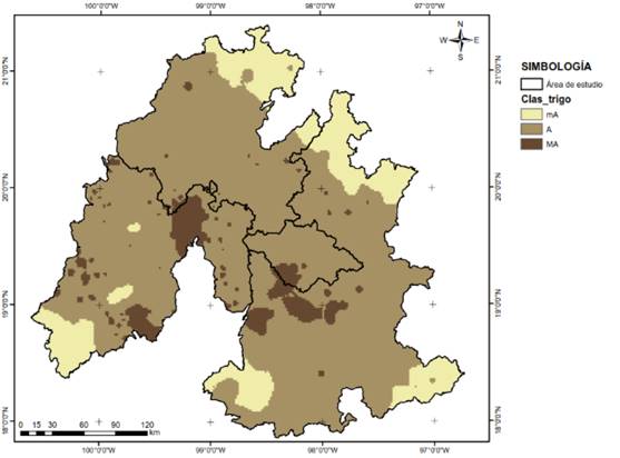
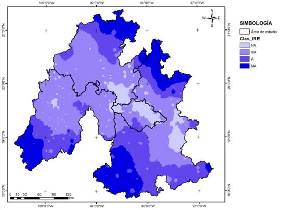
From the elaborated map, it was obtained that in the study area the conditions that are found for the establishment of the crop are: marginally apt (mA), apt (A) and very apt (MA) (Figure 1). With regard to the classification of the relative index of the disease (IRE) in cartographic presentation, it was obtained that the climatic conditions of the study area divide it into: Not suitable (NA), mA, A and MA (Figure 2).
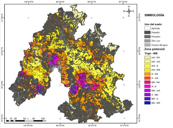
The combination of the wheat classification maps and the IRE made it possible to identify the potential zones for the increase of quality seed production (genetic, physical, physiological and sanitary) of the crop (Figure 3).
It is necessary to consider that varieties for rainfed crops are an important technological component for the producer, since they must have certain agronomic and phytopathological characteristics that allow them to achieve a good harvest, in the face of biotic and abiotic problems (Villaseñor and Moreno, 1998).
The best areas are those that are very suitable for cultivation and that do not have a high IRE, as is the case of Tepetitla, Nativitas, Santa Isabel and Tepeyanco. The final map was generated for storm conditions, with the mean average temperature and accumulated precipitation during the months of May to October obtained from climatological normals. The area was estimated for each type of land use in the region of the Central High Valleys (Table 4).
Table 4 Area estimation according to land use in Central High Valleys.
| Land use | Area (km2) |
| Agricultural | 37 370.03 |
| Body of water | 35 429.01 |
| Forest | 8 074.87 |
| Another use | 565.40 |
| Livestock | 173.64 |
| Total | 81 612.95 |
Table 5 shows the municipalities and the assigned classification according to the optimal or unsuitable environmental conditions for the crop and the pathogen.
Table 5 Municipalities classified according to environmental conditions for wheat production.
| Municipality | Classification wheat/IRE | Area (ha) |
| Huejutla of reyes (Hgo.) | mA - A | 31 868.28 |
| San Felipe Orizatlan (Hgo.) | mA - A | 24 318.59 |
| Atlapexco (Hgo.) | mA - A | 14 629.86 |
| Chiautla (Pue.) | mA - A | 12 801.1 |
| Ayotoxco of Guerrero (Pue.) | mA - A | 11 332.94 |
| Francisco Z. Mena (Pue.) | mA - A | 11 236.79 |
| Hueytamalco (Pue.) | mA - A | 11 228.1 |
| Tepehuacan of Guerrero (Hgo.) | mA- mA | 4 939.44 |
| Jocotitlan (Mex.) | mA- mA | 3 830.49 |
| Chiautla (Pue.) | mA- mA | 3 453.51 |
| Calnali (Hgo.) | mA- mA | 2 694.66 |
| Zinacatepec (Pue.) | mA- mA | 2 336 |
| Tianguistengo (Hgo.) | mA- mA | 2 090.08 |
| Huehuetla (Hgo.) | mA- mA | 1 871.16 |
| Tlaxco (Tlax.) | mA - A | 46 380.32 |
| Chalchicomula of Sesma (Pue.) | mA - A | 32 996.45 |
| Apan (Hgo.) | mA - A | 27 183.59 |
| Chignahuapan (Pue.) | mA - A | 24 954.17 |
| Palmar of Bravo (Pue.) | mA - A | 24 634.55 |
| Tepeyahualco (Pue.) | mA - A | 24 106.27 |
| Huamantla (Tlax.) | mA - A | 23 758.41 |
| Atizapan de Zaragoza (Mex.) | MA - A | 230.1 |
| Acuamanala de Miguel Hidalgo (Tlax.) | MA - A | 47.7 |
| Tochimilco (Pue.) | MA - A | 4 346.12 |
| Villa guerrero (Mex.) | MA - A | 4 087.69 |
| Atzitzihuacan (Pue.) | MA - A | 3 526.71 |
| Atlixco (Pue.) | MA - A | 3 127.63 |
| Puebla (Pue.) | MA - A | 2 786.03 |
| Huaquechula (Pue.) | MA - MA | 1 708.76 |
| Malinalco (Mex.) | MA - MA | 634.2 |
| Zumpahuacan (Mex.) | MA - MA | 15.32 |
| Hueyotlipan (Tlax.) | A - NA | 3 822.59 |
| Muñoz of Domingo Arenas (Tlax.) | A - NA | 1 445.18 |
| San Lucas Tecopilco (Tlax.) | A - NA | 482.32 |
| Españita (Tlax.) | A - NA | 6 004.71 |
| Apizaco (Tlax.) | A - NA | 1 449.91 |
| Xaltocan (Tlax.) | A - NA | 7 454.25 |
| Yauhquemehcan (Tlax.) | A - NA | 3 035.39 |
| Apizaco (Tlax.) | A - mA | 157.21 |
| Xaltocan (Tlax.) | A - mA | 45.33 |
| Ixtacuixtla de Mariano Matamoros (Tlax.) | A - mA | 3 003.06 |
| Panotla (Tlax.) | A - mA | 1 171.66 |
| Santa Cruz Tlaxcala (Tlax.) | A - mA | 157.84 |
| Apetatitlan de Antonio Carvajal (Tlax.) | A - mA | 529.48 |
| Tlaxcala (Tlax.) | A - mA | 363.21 |
| Tepetitla de Lardizabal (Tlax.) | MA - NA | 522.35 |
| Nativitas (Tlax.) | MA - NA | 697.4 |
| Santa Isabel Xiloxoxtla (Tlax.) | MA - NA | 108.55 |
| Tepeyanco (Tlax.) | MA - NA | 185.04 |
| Teolocholco (Tlax.) | MA - NA | 3.21 |
| Acuamanala de Miguel Hidalgo (Tlax.) | MA - NA | 306.81 |
| Santa Cruz Quilehtla (Tlax.) | MA - NA | 97.65 |
According to Figure 3, the state with the best characteristics for crop production and seed production is Tlaxcala in the municipalities of Nativitas, Tepetitla and Acuamanala. The less appropriate municipalities are: Huejutla, Francisco Z. Mena and Hueytamalco. It is important to mention that some municipalities may have more than one classification due to their physiographic and climatic characteristics.
Conclusions
The geographic information systems (GIS), allowed to determine the optimal production zones for wheat and seed increase, with the least potential damage from spike blight, considering the land uses.
According to the zoning, the northern part of the Central High Valleys region is a favorable area for the development of Fusarium sp. and marginally suitable for the establishment of wheat; in contrast, the central part is marginally suitable for the development of Fusarium sp. but suitable for the establishment of the crop, resulting in the best area to achieve greater production and obtain good quality seed.
Literatura citada
Brennan, J. P.; Warham, J. E.; Hernández, J. y Byerlee, D. y Coronel, F. 1990. Perdidas económicas ocasionadas por el carbón parcial del trigo en México. Centro Internacional del Mejoramiento de Maíz y Trigo (CIMMYT). México, D. F. 56 p. [ Links ]
CIMMYT. 2008. Laboratorio de sistemas de Información Geográfica. Zonas potenciales de cultivo de trigo. http://www.conabio.gob.mx. [ Links ]
Ecocrop. 2015. Ecocrop database. FAO, Rome, Italy. [ Links ]
FAO. 1994. AEZ in Asia. Proceedings of the regional workshop on agro-ecological zones methodology and applications. Bangkok, Thailand, November 1991. World Soil Resources Report 75. Rome, Italy. 17-23 pp. [ Links ]
FAO. 1997. Zonificación agro-ecológica (guía general). Boletín de suelos de la FAO núm. 73. [ Links ]
FAO. 2016. Agricultura mundial: hacia los años 2015-2030. [ Links ]
Fernández, R. y Fernández, X. 1934. La historia del trigo. Revista Crisol. [ Links ]
Flores, L. H. E.; Ireta, M. J. y Ruíz, C. J. A. 2007. Factores meteorológicos asociados al tizón de la espiga (Fusarium graminearum Schwabe) en trigo (Triticum aestivum L.). Rev. Méx. Fitopatol. 25(2). [ Links ]
Goswami, R. S. and Kistler, H.C. 2004. Heading for disaster: Fusarium graminearum on cereal crops. Molecular Plant Pathology. 5:515-525. http://www.fao.org/docrep/004/y3557s/ y3557s08.htm#TopOfPage. [ Links ]
IMTA. 2009. Extractor rápido de information climatológica version 3. [ Links ]
Ireta, M. J.; Sosa, M. C.; Romero, C. S. y Bekele, G. 1989. Estimación de las pérdidas en trigo (Triticum sp. L.) causadas por la roña (Fusarium graminearum Schw.). Agrociencia. 77:89-102. [ Links ]
Law, M. C.; Balasundram, S. K.; Husni, M. H.; Ahmed O. H. and Harun, M. H. 2009. Spatial variability of soil organic carbon in oil palm. Inter. J. Soil Sci. 4:93-103. [ Links ]
Magrin, G. y Travasso. M. I. 1997. Potencial de producción del cultivo de trigo (Triticum aestivum L.) en la región pampeana argentina. In: memorias de la reunión de planificación estratégica de trigo INTA-CIMMYT. Mar del Plata, Argentina. 34-45 pp. [ Links ]
Miller, J. D.; ApSimon, J. W.; Blackwell, B. A.; Greenhalgh, R. and Taylor, A. 2001. Deoxynivalenol: a 25 years’ perspective on a trichothecene of agricultural importance. In: Summerell, B. E.; Leslie, J. F.; Backhouse, D. Bryden, W. L. and Burgess L.W. Fusarium: Paul, E. Nelson Memorial Symposium. APS Press. St. Paul, MN, USA. 392 p. [ Links ]
Nicholson, P.; Gosman, N.; Draeger, R.; Thomsett, M.; Chandler, E. and Steed, A. 2007. The Fusarium head blight pathosystem: status and knowledge of its components. In: Buck, H. T. Nisi, J.E. and Salomón N. (Eds.). Wheat Production in Stressed Environments. Springer. Dordrecht, The Netherlands. 794 p. [ Links ]
Peña, B. R. J.; Pérez, H. P.; Villaseñor, M. E.; Gómez, V. M. M. y Mendoza, L. M. A. 2008. Calidad de la cosecha de trigo en México. Ciclo primavera-verano 2006. Publicación Especial del CONASIST-CONATRIGO, Tajín núm. 567, Col. Vertiz Narvarte, Delegación Benito Juárez, México, D. F. 28 p. [ Links ]
Pineda, S. D. L. y Suárez, H. J. E. 2014. Elaboración de un SIG orientado a la zonificación agroecológica de los cultivos. Ingeniería Agrícola. 4(3):28-32. [ Links ]
Siabato, W. y Yudego, C. 2004. Geoestadística y medio ambiente. Territorio y medio ambiente: métodos cuantitativos y técnicas de información geográfica. In: aportaciones al XI congreso de métodos cuantitativos, SIG, teledetección y Departamento de Geografía, Universidad de Murcia. Conesa, C. y Martínez, J. B. (Eds). Murcia, España. 11-25 p. [ Links ]
SIAP 2014. SIAP http://www.siap.gob.mx/agricultura-produccion-anual/. [ Links ]
Sip, V.; Chrpova, J.; Leisova, L.; Sykorova, S.; Lucera, L. and Ovesna, J. 2007. Implications for Fusarium head blight control from study of factors determining pathogen and DON content in grain of wheat cultivars. pp. 281-287. In: Buck, H. T. ; Nisi, J. E. and Salomón N. (Eds.). Wheat Production in Stressed Environments. Springer. Dordrecht, The Netherlands. 794 p. [ Links ]
Velázquez, P. D.; Formento, A. N.; Velázquez, J. C.; Schutt, L. S.; Velázquez, R. D; Figoni, G. J.; Melchiori, R. J. 2012. Asociación entre fusariosis de la espiga (Fusarium graminearum y Fusarium spp.), genotipos de trigo y diferentes dosis de nitrógeno. Campaña 2011, Paraná, Entre Ríos. In: XVI Jornadas Fitosanitarias Argentinas, Potrero de Los Funes, San Luis. [ Links ]
Villaseñor, H. E. y Moreno, G. R. 1998. Batán F-96, nueva variedad de trigo para siembras de temporal. Secretaría de Agricultura ganadería, Pesca y Alimentación (SAGARPA)-Instituto Nacional de Investigaciones, Forestales, Agrícolas y Pecuarias (INIFAP)- Centro de Investigación Regional Centro (CIR)- Campo Experimental Valle de México. Folleto técnico núm. 8. [ Links ]
Zadoks, J. C.; Chang, T. T. and Konsak, C. F. 1974. A decimal code for the growth stages of cereals. Weed Research 14:415-421. [ Links ]
Received: April 2018; Accepted: June 2018
 Este es un artículo publicado en acceso abierto bajo una licencia Creative Commons
