


Servicios Personalizados
Revista
Articulo
 texto en
  Inglés (pdf)
 Artículo en XML
 Referencias del artículo
 Enviar artículo por email
Indicadores
-
 Citado por SciELO
 -
 Accesos
Links relacionados
-
 Similares en
SciELO
Similares en
SciELO
Compartir

 Permalink
Revista mexicana de ciencias agrícolas
versión impresa ISSN 2007-0934
Rev. Mex. Cienc. Agríc vol.7 spe 16 Texcoco may./jun. 2016
Articles
Agroforestry for habitat conservation montezuma quail
1Posgrado en Ciencias Agroforestería para el Desarrollo Sostenible- Universidad Autónoma Chapingo. Carretera. México-Texcoco km 38.5, Chapingo, Texcoco 56230, Estado de México. México Tel: 595 952 540. (andchondo@gmail.com; carj49@hotmail.com; migueluribe123@gmail.com; hsantoyo@gmail.com; loel50@hotmail.com; alarab_11@hotmail.com).
2Universidad Autónoma Chapingo. Carretera. México-Texcoco km 38.5, Chapingo, Estado de México. México. C. P. 56230. Tel 595 952 1540.
This study presents the formulation and evaluation of two agroforestry technologies designed to conserve the habitat of Cyrtonyx montezumae in the UMA common El Rosario, Tlaxcala. An agroforestry diagnosis of UMA was performed using semi-structured interviews and participant observation. ArcGIS 10.1 was used for the identification of priority parcels within the agricultural area. In addition agroforestry technologies were proposed to improve the available habitat of the species, they were evaluated same as the net present value indicator to determine profitability. They were identified, evaluated and ranked according to their quality and availability of habitat a total of 72 plots with an area of 270 ha. Two types of plots were classified: type 1, those with lack of shrub cover and those with type 2 good quality habitat threatened by grazing. Each type of plots was assigned an agroforestry technology; the type 1, alley cropping and type 2, hedgerows. The proposal for agroforestry plots type 1 technology is profitable when working with plots of five hectares or more and receives government support. The technology proposed for type 2 plots profitable given the products obtained from the selected species. It was concluded that the proposed agroforestry technologies can contribute to habitat conservation of Cyrtonyx montezumae and that the selection of perennials multipurpose is paramount in the design of an agroforestry technology that is intended to be profitable.
Keywords: Cyrtonyx montezumae; alley cropping; hedgerows; profitability
Este estudio presenta la formulación y evaluación de dos tecnologías agroforestales, diseñadas para la conservación del hábitat de Cyrtonyx montezumae en la UMA ejido El Rosario, Tlaxcala. Se realizó un diagnóstico agroforestal de la UMA mediante entrevistas semiestructuradas y observación participativa. Se utilizó ArcGIS 10.1, para la identificación de parcelas prioritarias dentro del área agrícola. Además se propusieron tecnologías agroforestales para mejorar el hábitat disponible de la especie, mismas que fueron evaluadas con el indicador valor presente neto, a fin de determinar su rentabilidad. Fueron identificadas, evaluadas y clasificadas de acuerdo a su calidad y disponibilidad de hábitat un total de 72 parcelas con una extensión de 270 ha. Se clasificaron dos tipos de parcelas: el tipo 1, aquellas con carencia de cobertura arbustiva y el tipo 2 aquellas con hábitat de buena calidad amenazado por el pastoreo. A cada tipo de parcelas se le asignó una tecnología agroforestal; a las tipo 1, cultivo en callejones y a las tipo 2, cercos vivos. La tecnología agroforestal propuesta para las parcelas tipo 1 resulta rentable cuando se trabaja con parcelas de cinco o más hectáreas y se recibe apoyo gubernamental. La tecnología propuesta para las parcelas tipo 2 resulta rentable dados los productos que se obtienen de la especie seleccionada. Se concluyó que las tecnologías agroforestales propuestas pueden contribuir a la conservación del hábitat de Cyrtonyx montezumae y que la selección de plantas perennes de usos múltiples es primordial en el diseño de una tecnología agroforestal que se pretende sea rentable.
Palabras clave: Cyrtonyx montezumae; cercos vivos; cultivo en callejones; rentabilidad
Introduction
The creation of the management unit for the conservation of wildlife (UMA) was approved in Mexico (1997); strategy whose objectives aim to regulate the conservation and sustainable use of biodiversity in the country and diversify sources of income in rural areas. In recent decades has highlighted the importance of agroforestry in the quality of life of people who decide to use it, to the extent that some authors mention it as an alternative to achieve rural development (Krishnamurthy and Ávila, 1999). The agroforestry refers to the systems and technologies of land use woody perennials managed in predetermined combination with agricultural crops and domestic animals, looking for maximizing the benefits from the best land use.
Equally important, recently it has begun to recognize the role of agroforestry in the conservation of biodiversity (Bentrup, 2014), the same that has begun to look more closely given its potential for managing wildlife. However, in Mexico there are very few studies that show how the use of agroforestry can contribute to meeting the objectives of conservation and development looking for the UMA. Therefore this paper seeks to contribute to knowledge about the potential of agroforestry through their technologies to contribute to the implementation of the objectives of the UMA. For this, we worked with the UMA common El Rosario in the state of Tlaxcala. This UMA represents an excellent opportunity to study the potential of agroforestry in the management of wildlife in agricultural areas of central Mexico. In this UMA montezuma quail (Cyrtonyx montezumae) is handled, which is subject to special protection under Mexican Official Standard NOM-059- SEMARNAT-2010 because its habitat is threatened among other things by overgrazing.
Consequently, the objective of this work was to propose and evaluate agroforestry technologies that allow conserve the habitat of the montezuma quail in the UMA common El Rosario, through agroforestry diagnosis of common and UMA, identification and diagnosis of the priority areas for the species and assessing the financial impact of the proposals.
Materials and methods
Study area
In Figure 1 the common El Rosario which is located in the municipality of Tlaxco, Tlaxcala at an altitude between 2 592 and 3 397 m (Villordo, 2013) is shown; with annual temperatures of 1.11 to 24.7 °C, annual rainfall of 687.8 mm and climates type (C(w1)) y (Cb’(w1)) corresponding to the sub-humid and humid temperate subhumid (INAFED, 2006).

The vegetation in the study site is characteristic of pine (Pinus spp.) oak and transition zones, composed of various types of pine, oak (Quercus spp.) and juniper (Juniperus deppeana). It is also possible to find several species of wild animals such as wild rabbit (Sylvilagus cunicularis), young rabbit (Sylvilagus floridanus), gray squirrel (Sciurus aureogaster), skunks white back (Corepatus mesoleudu), opossum (Didelphys marsupials), bobcat (Lynx rufus), black-tailed jackrabbit (Lepus californicus), montezuma quail (Cyrtonyx montezumae) and rattlesnake (Crotalus triseriatus) (Villordo, 2013).
The UMA has an area of 3 028 ha, formed 55% of parceled area (1 665 ha) intended for rainfed agriculture, 42% for common use land (1 269 ha) intended for logging and 3% intended as a human settlement (94 ha), according to the Census and Agrarian History Cores (PHINA, 2015).
Agroforest diagnosis
The agroforestry diagnosis of UMA common El Rosario was carried out by the methods of moderate participant observation and semi-structured interview in the period 2014 to 2015. Referencing the Rapid appraisal methodology of agroforestry practices, systems and technology (Joshi et al., 2013). For this work step five of the methodology, corresponding to the economic quantification of inputs and outputs of agroforestry technologies present for calculating profitability was excluded.
The interviews were applied to the main stakeholders of the UMA: president and president (founder of the UMA) of the common and the technician responsible for it.
Identification and delimitation of priority areas
Priority areas were identified by geospatial analysis of the UMA, based on geographical features preferred by the species Cyrtonyx montezumae. These were: slopes between 20 and 30 degrees in any cardinal point and land with exposure north (including northeast and northwest). ArcGIS version 10.1 and digital elevation model for the state of Tlaxcala (INEGI, 2012): for this analysis the geographic information system (SIG) was used.
Once the priority areas identified parcels to which the proposals would adapt agroforestry were defined, making the intersection of these areas with the map of the common parcels as priority should thus obtaining plots (CONAFOR, 2015).
Habitat assessment within the priority parcels
For the evaluation of the montezuma quail habitat within the priority plots it was taken as a guide tool bobwhite quail habitat appraisal tool (White et al., 2005). That while it is designed to assess the habitat of the species Colinus virginianus allowed during 2015 to assess the state of available habitat for quail in the UMA, given the similarities in space requirements and coverage of both species. Regardless of the diagnosis of food availability, since the diets of both species are different. Habitat evaluation was carried out by random transects with meandering pattern. Assigning a number from 1 to 10 each.
With the information obtained in the evaluation plots as "type 1" were classified those plots with less than 8 average rating, and "type 2" those plots with an average grade greater than or equal to 8. With this classification and based on observations made on field trips and discussion with the team agroforestry technologies (TAF) they were selected to design.
Financial evaluation of proposals TAF
To calculate the profitability of the proposals of this paper indicator was calculated net present value (VPN). In turn, the evaluation was performed by analyzing various scenarios, based on the possible number of plants and percentage of use thereof, for each of the TAF proposals. To calculate the cash f lows required for the establishment, maintenance and use of the TAF proposals were estimated, these were estimated using data from respondents peasant and use market prices to value. The financial evaluation was performed in Microsoft Excel using the "VNA" function and applying a discount rate of 5%. The VPN calculation was performed for each of the TAF proposals, under the following assumptions:
TAF for plots type 1
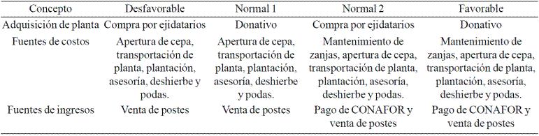
A range of 100 to 800 trees was evaluated (Juniperus deppeana), in multiples of 100 per hectare; three different extensions were evaluated: 4.2 ha, average length of type 1 plots; 5 ha, minimum to apply to support CONAFOR (RF6, for agroforestry systems) extension; and 241 ha, total area of the 58 plots type 1; a survival of 75% of the planted trees was considered; tree harvesting in the year 20 (planning horizon: 20 years); use through sale of poles; utilizations of 10, 50 or 100% of the surviving plants; weeding is considered 3 years from the planting of plants; depreciation of equipment and tools year 1 to 10; is whether or not access to government support will have to pay for technical assistance; unfavorable normal standard 1 and 2 and Pro (Table 1): Finally, four scenarios were considered.
TAF for plots type 2
Establishing living at distances of 1, 1.5, 2, 2.5 and 3 meters between plants pulque maguey (Agave atrovirens) fences; two different extensions were evaluated: 2 ha, average length of type 2 and 29 ha plots, extension of the 14 plots of type 2; 75% survival of planted maguey; pencas use of year 5 to year 15 (planning horizon: 15 years); use of 2, 4 or 6 stalks per plant; 8 tillers annual harvest in years 5, 7, 9, 11, 13 and 15; Weeding is considered only the first year after planting the plants; no maintenance is performed trenches; is whether or not access to government support will have to pay for technical assistance; depreciation of equipment and tools year 1 to 10; four different scenarios were considered: unfavorable, normal, standard 1 and 2 and pro (Table 2).

Results
Agroforest diagnosis of common El Rosario
The common has a wide variety of productive activities; thanks to the more than 1 200 ha of forested area (common area); for which it receives year after year, a significant sum of federal and private support. In addition, the peasant have over 1 600 ha of agricultural area where corn temporarily for human and animal consumption is grown and harvested abundantly, malting barley. In addition, it is mentioned that this crop is affected every year by snail plague, same as combat with burning herbs and grasses.
The forest area within the common is the area that best handles and preserves. This forest common members obtain firewood and wood poles for own consumption and for sale. For this reason there seems to be a palpable need for peasant to incorporate or increase the arboreal component in the area of plots for the production of wood products. This despite the peasant know the benefits it brings the presence of trees on farmland, reason why they have lasted through the years. For the area of plots besides being the agricultural area of the common, it is also the only space within this where grazing animals belonging allowed its inhabitants. This exclusively in areas away from crops and under strict supervision of a pastor. That according to the same peasant hardly met.
Within the plots it was possible to identify three agroforestry technologies: 1) scattered trees; 2) trees on boundaries; and 3) alleycropping. Them selves are identified by respondents peasant, as trees in plots, boundaries and "metepantles" or trenches, respectively. As for the tree components present in most agricultural plots the most abundant species are, at first glance, the juniper (Juniperus deppeana) and pulque maguey (Agave atrovirens), and can be found in any of the three TAF above. Most of these trees were born in situ, except for other tree species such as wild cherry (Prunus serotina subsp. capuli) and pine (Pinus spp.). Were planted intentionally by the owners of some plots. This being the reason why there is no deliberate spatial distribution of the arboreal component in this area.
With regard to the ownership and use of trees in the same area, each peasant is responsible for the management and destination given to them within their plots, hence some of them have more trees than others. Similarly each peasant is free to make their trees pruning if any part of these interfere with agricultural activities or shade crops. The same members of the common respondents recognize that it is rare that someone decides to fell a tree plots area since the needs of timber, fuel and poles are satisfied with the trees of the forest, or failing to nearby sawmills.
In the case of existing plots in the area of maguey, few peasant that seeded and grown, even though this species is highly valued by them. In addition to being identified as an ideal to withstand the weather conditions of the region (Rendón, 1990; Menegus and Leal, 2009) species. The existing desgane by planting this crop because during the 90's and 00's has suffered from a severe wave of fleshy leaves of the maguey and quiotes common theft. Table 3 shows the results on agroforestry situation common El Rosario are presented through a FODA analysis.

Identification of priority areas for habitat conservation
Since the common area north of the UMA common El Rosario is intended only to forestry and tree cover that constitutes not provide the right conditions for the development of Cyrtonyx montezumae, it was decided to work exclusively in the area plots; same as for its open, grass and trees and shrubs scattered spaces is ideal for the development of montezuma quail populations. A total of 590has to comply with one or both of the criteria selected for identifying priority habitat for montezuma quail identified. Of these 590 has only identified the 13.18% (77.7 ha) are located in the area of plots, while the rest are located in common area, equivalent to 86.82% (512.2 ha).
Once the priority areas identified plots in which they are contained, obtaining a total of 72 plots equivalent to an area of 270 ha, same that were considered priority for habitat management Cyrtonyx montezumae into the UMA were determined.
Evaluation of priority plots
The results of the evaluation of habitat for moctezuma quail within 72 plots were varied although the vegetation is fairly homogeneous, but not its abundance. The ratings assigned to each of the transects could be observed as the quality and quantity of shrub cover in seven of the ten areas assessed, is the factor that got the lowest scores in both the criterion of habitat for breeding chicks like shrub cover. For their part, they were presented conditions close to optimal habitat for quail in the other three areas evaluated. However, no certain evidence of possible conservation and permanence of these in the long term was found.
Based on the above results, the priority plots plots as type 1 and type 2. The type 1 plots covering an area of 214 ha, with an average area of 4.2 ha and is the coverage provided by the limiting factor shrub species were classified more common. Meanwhile type 2 plots comprise an area of 29 ha, with an average area of 2 ha and have suitable conditions to meet the coverage requirements and space for quail common; however, no evidence to ensure their protection and conservation threats to which the area is subject parcel was found. In addition, during field trips overgrazing was observed in some of the evaluated plots, evidence of feral dogs and the use of fire in some plots. The latter attributed to people who graze their animals and make use of it to promote regeneration of pastures or, failing that, is used by some peasant for the elimination of the pest snail.
Selection and design of agroforestry technologies (TAF)
Based on the results obtained in the agroforestry diagnosis and assessment of habitat Cyrtonyx montezumae, it was determined that the proposed TAF for type 1 plots should be aimed at improving existing metepantles and to increase the abundance of trees and shrubs. At the same time, for type 2 plots saw a TAF that allowed the conservation of existing pastures and ensure the permanence in the long run the current habitat, using a tree species adapted to the site and whose products represent sources of income for peasant.
Alley cropping plots for priority type 1
Selected for the type 1 TAF plots were alleys in agricultural crops, established on existing metepantles devoid of trees and shrubs. This technology was considered suitable to provide quail populations present with shrub cover, remedied the main limitation of these plots. Likewise this TAF is considered to take advantage of those unused spaces located between the agricultural parcels, as proposed Ffolliott and Brooks (1994). The tree species selected for the establishment of alley cropping is the juniper (Juniperus deppeana), given their representation in the area of plots, the availability of the species in nurseries in the state, its morphology; which if managed properly can keep your shrubby form (CONAFOR, 2003).
TAF profitability for type 1 plots
In Figure 2 you can see the different behaviors of the VPN of the TAF proposal for those peasant with less than five hectares (with an average of 4.2 ha).

Figure 2 From left to right, VPN of different scenarios for parcels of less than 5 ha and equal to 5 ha.
These results indicate that the most desirable from the financial point of view, is not investing in the TAF; without exception for any tree density or percentage of utilization.
Similarly in Figure 2 the VPN of the proposal shown for those landowners with plots five hectares (suitable for support RF6). In this figure it can be seen that under normal 1 unfavorable scenarios and any percentage of the most convenient utilization is not set TAF proposed. In contrast to the usual 2 and a favorable scenarios most convenient is the establishment of TAF with the number of trees that indicate support Pronafor (400 trees per ha).
Finally, as if the owners of the 58 parcels that make up the type 1 plots peasant decide to organize so that both less than five hectares as those with more than five may apply to the support RF6 of Pronafor, the behavior would be achieved TAF proposal VPN shown in Figure 3.

It is important to note that despite the higher profitability is obtained with the exploitations of 50 and 100% of the trees, these types of exploitation may compromise the objective of habitat conservation for which it proposed this TAF. Of these exploitations chosen, especially 100% of the trees, would take the proposal had the function of a forest plantation and not to provide the montezuma quail shrubby protection.
Hedgerows for priority parcels type 2
The TAF selected and proposed for type 2 plots was to live with maguey fences. This TAF was chosen and not live posts for two reasons: 1) there is evidence that living poles can damage the long-term wildlife species that thrive in grasslands; as is the quail (Allen, 1994; Bentrup, 2014); and 2) the potential use of species found locally for the establishment of hedgerows and as a source of income for landowners. We chose to use the maguey (Agave atrovirens) given the multiple products and services that the species can provide. Likewise the hardness and thickness of the stalks once in adulthood, can prevent the passage of cattle into parcels interested in keeping.
TAF profitability for type 2 plots
By sensitivity analysis performed for this TAF returns offered various different densities maguey plants (Table 4) as well as the possible number of pads that could be harvested from them were obtained.

The results obtained for this TAF may serve as a reference for selecting the number of plants to sow (the distance between them) and the number of stalks to harvest.
Given the various products that can be obtained from maguey (fleshy leaves, tillers and honey water) and based on the results obtained for the VPN indicator (Figure 4) under any scenario analyzed, the proposal for the establishment of hedgerows with maguey is a proposal feasible to invest.

Figure 4 From left to right, VPN of different scenarios for 2 ha and 39 ha (total length of type 2 plots).
Similarly, in Figure 4 it can be seen how a higher plant density is greater profitability, presenting a decreasing trend with increasing distance between them. At the same time the figures we can see how even a greater distance than normal (2 m) for intensive plantations of maguey (Aguilar et al., 2014),positive returns are obtained, which could allow a utilization be given only two pencas by maguey; thus fulfilling sustainable use for the benefit of peasant and their families while the conservation objective is met, as proposed Harris (1984).
As a result of the above, it might seem appropriate to consider the maguey, given its high profitability, as the species to be used in both TAF proposals; however, it is important to consider the structure of the maguey (thick fleshy leaves) do not have the ability to provide shrub cover that requires moctezuma quail to perform everyday activities.
Conclusions
The diagnosis of agroforestry common status allowed the selection, design and development of agroforestry technologies adapted to environmental issues such as climate, ecosystems and wildlife, and to economic and social conditions thereof. Similarly, the assessment of the current status of the Montezuma quail habitat within the UMA, allowed adapt agroforestry technologies proposed to the biophysical requirements of the species in question.
The assessment of profitability showed that agroforestry projects habitat conservation Cyrtonyx montezumae through alley cropping with Juniperus deppeana is not a profitable option for landowners, unless they possess more plots than five hectares or failing to cooperate with other peasant and implement agroforestry systems support the National Forest Program of the National Forestry Commission.
Meanwhile, agroforestry technology hedgerows with Agave atrovirens proved quite profitable due to multiple products that are obtained from the species and their market that exists in the region.
Although one might think that the profitability of an agroforestry project habitat conservation is a function of plant density and percentage of use thereof, the present study can prove that the profitability of an agroforestry technology that presents a higher density and a higher percentage of use, it may be modest when contrasted with a smaller number of plants or smaller percentage of utilization, considering a tree or shrub species, whose products can transform into higher incomes. Therefore, the selection of species is a major factor in the design of agroforestry technologies that are intended to be profitable.
Literatura citada
Allen, A. W. 1994. Agroforestry and wildlife: opportunities and alternatives. In: agroforestry and sustainable systems symposium. Fort Collins, Co. 329 p. [ Links ]
Aguilar, J. B.; Enríquez, V. J. R.; Rodríguez, O. G.; Granados, S. D. y Martínez, C. B. 2014. El estado actual de Agave salmiana y Agave mapisaga del Valle de México. Rev. Mex. Agroec. 1(2):106-120. [ Links ]
Bentrup, G. 2014. A win - win on agricultural lands: creating wildlife habitat through agrforestery. Inside Agroforestry. 23(1):6-7. [ Links ]
CONAFOR. 2003. Juniperus deppeana. Paquetes tecnológicos. México. 534 p. [ Links ]
CONAFOR. 2015. Mapa del programa Procede para el ejido El Rosario. Dpto. de conservación y restauración de suelos. CONAFOR Tlaxcala. México. 387 p. [ Links ]
Ffolliott, P. F. and Brooks, K. N. 1994. Production agroforestry systems: their contribution to sustaintability in the semiarid western U. S. In: agroforestry and sustainable systems symposium. Fort Collins, Co. [ Links ]
Harris, L. D. 1984. The fragmented forest: Island biogeography theory and the preservation of biotic diversity. University of Chicago Press. 211 p. [ Links ]
INAFED. 2006. Tlaxcala - hidrografía. 32 p. [ Links ]
INEGI. 2012. Geografía. 43 pp. [ Links ]
Joshi, L. M.; Van Noordwijk, E.; Martini, O. K. and Janudianto, E. N. 2013. Rapid appraisal of agroforestry practices, systems and technology (RAFT). Bogor, Indonesia. World Agroforestry Centre (ICRAF). 36-42 pp. [ Links ]
Krishnamurthy, L. y Ávila, M. 1999. Agroforestería básica. FAO. México. 254 p. [ Links ]
Menegus, B. M. y Leal, J. F. 2009. Las haciendas de Mazaquiahuac y El Rosario en los árboles de la revolución agraria 1910-1914. Universidad Nacional Autónoma de México (UNAM). 233- 275 pp. [ Links ]
Padrón e Historial de Núcleos Agrarios (PHINA). 2015. El Rosario. Registro Agrario Nacional. México. 177 p. [ Links ]
Rendón, R. 1990. Dos haciendas pulqueras en Tlaxcala 1857-1884. Universidad Iberoamericana(UI). México. 97 pp. [ Links ]
SEMARNAT. 2010. NOM-059-SEMARNAT-2010.DOF. México, D.F. 56p. [ Links ]
Villordo, A. 2013. Plan de manejo de vida silvestre para la UMA ejido El Rosario. Tlaxcala. 132 p. [ Links ]
White, B.; Graham, P. and Pierce, R. A. 2005. Missouri bobwhite quail habitat appraisal guide. University of Missouri Extension. Missouri, U. S. A. 475 p. [ Links ]
Received: January 2016; Accepted: April 2016
 Este es un artículo publicado en acceso abierto bajo una licencia Creative Commons
