


Servicios Personalizados
Revista
Articulo
 texto en
  Inglés (pdf)
 Artículo en XML
 Referencias del artículo
 Enviar artículo por email
Indicadores
-
 Citado por SciELO
 -
 Accesos
Links relacionados
-
 Similares en
SciELO
Similares en
SciELO
Compartir

 Permalink
Revista mexicana de ciencias agrícolas
versión impresa ISSN 2007-0934
Rev. Mex. Cienc. Agríc vol.7 spe 13 Texcoco ene./feb. 2016
Articles
Characterization of forest fuel load for the management of carbon reservoirs and the contribution to climate change
1 Campo Experimental Centro Altos de Jalisco-INIFAP. Tepatitlán de Morelos, Jalisco. C.P. 47600 Tel: 018000882222. (xelhuantzi.jaqueline@inifap.gob.mx; rubio.ernesto@inifap.gob.mx; flores.hugo@inifap.gob.mx; delamora.celia@inifap.gob.mx).
2 Centro Nacional de Investigación Disciplinaria en Relación Agua, Suelo, Planta, Atmósfera- INIFAP. Gómez Palacio, Durango. C. P. 35140. Tel: 01 871 1590104. (villanueva.jose@inifap.gob.mx).
Climate change is one of the greatest environmental threats facing humanity. Burned biomass during the fires is an important source of greenhouse gases (Beitler, 2006). Various researches indicate that for every ton of biomass present in the forest, half are carbon (Brown et al., 1996). For a wildfire to occur requires three basic factors: combustible material, favorable environmental conditions and initiation factor (Santiago et al., 1999). Forest fuels are one of the most important factors in the management and control of the fire, since this can be manipulated (Flores, 1996). In Mexico has been made important an important work to characterize them (Xelhuantzi et al., 2011); however, researches carried are made in specific areas, limiting to know a general context on forest fuels. This paper describes the estimation of forest fuels in forests from Jalisco, through in situ data collection methods and loading estimates per unit area. Sites with dead fuel load of up to 840.85 t ha-1, different values for the dead fuels complex and differences between fuel load from coniferous forests and oak were found. The result obtained allows setting the bases to implement fuel management strategies that favor their reduction, thus avoiding catastrophic fires that release into the atmosphere large amounts of greenhouse gases.
Keywords: characterization; climate change; fire; fuel; management
El cambio climático es una de las mayores amenazas medioambientales a las que enfrenta la humanidad. La biomasa quemada durante los incendios son fuente importante de gases de efecto invernadero (Beitler, 2006). Diversas investigaciones señalan que por cada tonelada de biomasa presente en el bosque, la mitad corresponde a carbono (Brown et al., 1996). Para que un incendio forestal ocurra se requiere de tres factores básicos: material combustible, condiciones ambientales favorables y un factor de inicio (Santiago et al., 1999). Los combustibles forestales constituyen uno de los factores más importantes para el manejo y control de los incendios pues, este puede manipularse (Flores, 1996). En México se han realizado importantes trabajos para caracterizarlos (Xelhuantzi et al., 2011); sin embargo, las investigaciones realizadas son ejecutadas en áreas específicas, limitando conocer un contexto general sobre los combustibles forestales. En el presente trabajo se describe la estimación de combustibles forestales en zonas de bosque del Estado de Jalisco, a través de métodos de recolección de datos in situ y estimaciones de cargas por unidad de área. Se encontraron sitios con cargas de combustibles muertos de hasta 840.85 t ha-1, diferentes valores para el complejo de combustibles muertos y diferencias entre las cargas de combustibles de los bosques de coníferas y encinos. Los resultados obtenidos permiten cimentar las bases para la implementación de estrategias de manejo de combustibles que favorezcan su reducción evitando así, incendios catastróficos que liberen a la atmósfera grandes cantidades de gases de efecto invernadero.
Palabras clave: cambio climático; caracterización; combustibles; incendios; manejo
Introduction
Climate change is one of the greatest environmental threats facing humanity. Currently it is very argued, mainly because the estimates made need to be substantiated with more information (UNEP, 1992). It is necessary to carry studies that help assess the causes and effects of different aspects that favor this phenomenon (Bettwy, 2007). Forest fires are a major ecological factor, not only as a destroyer but as a modeler agent of the ecosystems, since they are a detonator for the plant succession process, which tends to ensure the continuity of the same (Pickett and White 1985). Fires can be caused by nature (Martinez and Rodriguez, 2008), or by anthropogenic action (Flores et al., 2010). Burned biomass during fires is an important source of greenhouse gases and photo-chemically reactive gases (Beitler, 2006), considered as one of the main players contributing with pollutants into the atmosphere (Flannigan and Wagner, 1991). There have been extensive researches to understand the emission of components and aerosol particles that are released by burning biomass on agricultural land (Andreae and Merlet, 2001); however, information on spatial and temporal extent of fires in forest areas and its association with gas emission is very limited (Guenther et al., 1995).
Various researches indicate that for every ton of biomass present in the forest, half are carbon, with variations depending on species therefore, to perform biomass measurements in forests will help to estimate the amount of carbon concentrated in them and their possible release into the atmosphere during a fire (Brown et al., 1996). For a wildfire to occur requires three basic factors: combustible material, favorable environmental conditions and initiation factor (Santiago et al., 1999).
Forest fuels constitute one of the most important factors in the management and control of the fire, therefore this can be handled either by eliminating it or decreasing it (Flores, 1996). It is necessary to implement fuels management strategies that favor their reduction, to do so, it is necessary to characterize fuels and to know its spatial distribution. This usually is too costly and difficult in fact, the definition of spatial distribution of forest fuels has been one of the most complex challenges that forest scientists have faced (Keane et al., 1999; Flores, 2001).
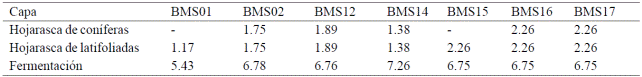
According to its condition, fuel can be divided into living and dead. The first include grasses, shrubs and trees or plants under canopy, while dead fuels are represented by trunks, branches and leaves normally found on the ground (Villers, 2006). The dead fuels are divided in to fine and coarse (Flores and Benavides, 1994). To be used as a measurable variable, the amount of fuel must be expressed by size class (Villers, 2006), associated with the time it takes to reach equilibrium with ambient moisture and called "time lag". This is defined as the period in which a fuel loses or gains (for moisture conditions) two-thirds of the difference between its initial moisture content and the environment (Foresberg, 1971). As the fuel is larger, it will lose or gain moisture more slowly; i.e. will have a longer time lag (Villers, 2006). Thus, there are fuel of 1, 10, 100 and 1000 h (Table 1).

For dead fuels, the survey technique most commonly used is the in situ planar intersection described by Brown et al. (1982)) by which the volume of the dead fuels is estimated through fast and simple procedures, with the possibility of being used in any type of forest (Bautista et al., 2005).
The importance of dead fuels lies where it usually starts ignition. Light fuel burn easily and ignite medium fuels, these in turn ignite heavy fuels (SEMARNAT, 2007). Dead fuel combustion serve as ignition factors of living fuels, usually through herbs and shrubs that serve as ladder for fire to spread from the surface to treetops, allowing the propagation of large fire and releasing into the atmosphere concentrated carbon on the various strata of fuels complex.
Nationally there has been significant work to characterize forest fuels present in ecosystems (Flores et al., 2010), the state of Jalisco has not been the exception (Xelhuantzi et al., 2011); however, researches conducted are generally performed in given areas fulfilling specific objectives, limiting to know the overall State context on forest fuels.
In order to inventory the country's forest resources, it has been established an activity called National Forest and Soil Inventory (INFyS) (CONAFOR, 2011) which, in its versions 2009, 2010 and 2011, included in its actions to inventory dead forest fuels as part of its methodologies. The information collected in the INFyS is an important source of data that can generate an overall context on fuel load present at national, regional and state level, serving as a benchmark for researches carried at more accurate scales.
In the present study was made an estimate of dead forest fuel load in forests of conifers and oaks forest from Jalisco, using field data collected by INFyS 2009, 2010 and 2011. The results allow lay the groundwork to implement management strategies that favor fuels reduction, thus avoiding catastrophic fires that release large amounts of greenhouse gases into the atmosphere.
Materials and methods
The state of Jalisco is located in the western portion of the country in the extreme coordinates 18o 57' to 22° 45' north latitude and 101° 28' to 105° 42' west longitude. It represents 4% of the total national surface and wooded area of 3.5 million hectares, of which 51% is forest and the 49% left is jungle. It has 19 natural protected areas with an estimated total area of 833 442 thousand ha (Sandoval et al., 2014).
Field data used for the analysis was collected in situ through resampling 2009, 2010 and 2011 from INFyS. The sampling design from INFyS is systematic stratified, where the layers are formed by the spatial distribution of the various types of vegetation and location of each cluster survey is governed by a grid of 5 x 5 km for forest areas (CONAFOR, 2011) (Figure 1).

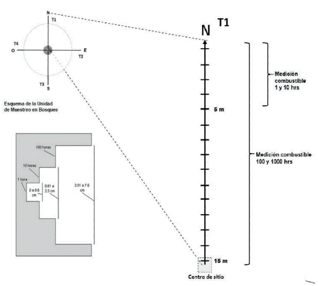
INFyS samplings are constituted by four circular recording units or equidistant sites from the center to every 45.14m, whose distribution corresponds to a "Y inverted" (Figure 2).

On site 3 of each cluster the measurements for the evaluation of dead fuels forest are made by planar intersections technique described by Brown et al. (1982). Each cluster has four transects of 15 m length, where the frequencies of pieces from fallen woody material (MLC) are recorded. In the last five meters transect the pieces of 1 h and 10 h are recorded throughout the transect pieces of 100 and 1 000 h; in addition the diameter of woody parts of 1 000 h are measured. Also records information regarding fallen leaves layer (H) and fermentation (F) at 2 and 4 m from transects (Figure 3).
Data processing was at state level, 434 sampling sites. To calculate the loading of fallen woody material, the following equation described by Morfin et al. (2012) was used.
 1)
1)
Where: C= fuel loading (mg/ha); k= 1.234; ΣD^2 = sum of the square diameter of particles intersected; GE= specific gravity; c= slope correction factor and L= transect length.
For fuels of 1, 10 and 100 h, a simplification of the above equation, described by Morfin et al. (2012) was used.
 2)
2)
Where: C= fuel loading (mg/ha) of 1, 10 and 100 h; K= 1.234; GE= specific gravity; DCP= quadratic average diameter of each category (1, 10 and 100 h); F= frequency of particles intersected; c= slope correction factor; and L= transect length.
For slope correction factor the following equation was used.
 3)
3)
Where: c=slope correction factor.
To calculate fermentation fuel load, the following equation, described by Morfin et al. (2012) was used.
 4)
4)
Where: Cf= fuel loading fermentation (mg/ha); Oe= depth in cm of fermentation layer; and DA= bulk density.
To calculate fuel loading of fallen leave, the following equation described by Morfin et al. (2012) was used.
 5)
5)
Where: Ch= fuel loading fallen leaves (mg/ha); Oi= depth in cm of fallen leaves; and DA= bulk density.
Information regarding GE and DCP was consulted in the document entitled "characterization and quantification of forest fuels" (Morfin et al., 2012) where these variables are classified by diameter category of fuel, vegetation type and bioclimatic region (Table 2).

Moreover, DA values were consulted in the publication entitled "photo series for the quantification of forest fuels in Mexico" (Morfin et al., 2007) in which, estipulates their use depending on vegetation type and bioclimatic region to calculate fuel loads of fallen leaves and fermentation (Table 3).
Estimates of fuel load in t ha-1 were made using the system to calculate forest fuels (SICCO, 2015) which is part of the tools developed by the wildfires program from the National Forest, Agriculture and Livestock Research Institute (INIFAP), and considers for their processes the equations described above.
The results of the estimates were structured in plain text files and subsequently processed their descriptive statistics with the Statistical Analysis System® (SAS) system. A normality test was made to the resulting data through Anderson Darling (Chambers et al., 1983) method and applied normalization to the resulting data of total fuel load by transformation method from Johnson (Chou et al., 1998). Finally, an analysis of variance (Weaver, 1999) was performed in order to verify the existence of significant difference between total fuel loading according to vegetation class IV series (INEGI, 2012) identified in the clusters.
Results and discussion
434 sampling sites for the state of Jalisco were processed. According to the standard classification IV from the National Institute of Statistics, Geography and Informatics (INEGI), for land use and vegetation, 173 sites correspond to coniferous forest and 261 to oak forests. Table 4 shows values found ranging from 0 to 840.85 t ha-1 on total fuel that is, the sum of MLC, H and F. The asymmetry values indicate that data show a positive bias. This is confirmed by the value from the third quartile, whose figure is well below the maximum found, indicating that, despite the existence of extremely high fuel loads, most are concentrated below the 140.40 t ha-1.
Table 4 General Statistic of fuel loads MLC, H and F.
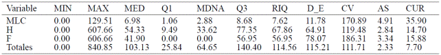
**MIN= mínimo; MAX= máximo; MED= media; Q1= cuartil 1; MDNA= mediana; Q3= cuartil 3; RIQ= rango Intercuartílico; D_E= desviación estándar; C_VAR= coeficiente de variación; AS= asimetría; CUR= curtosis.
Figure 4 shows that values higher than 312.24 t ha-1 in the total fuel can be considered as atypical. Fuels H and F are included mostly below the third quartile regarding total fuel, while MLC values are considerably smaller compared to the rest.

Figure 4 Scatter plot and asymmetry values of MLC, H, F and total forest fuel load. X axis= t ha-1, Y axis= fuel type.
Fuel values comprising MLC 1, 10, 100 and 1000 h are found in Table 5. The higher loads are placed on 1 000 h fuels both firm and rotten however, also concentrate higher coefficients of variation and a pronounced positive bias, shown in Figure 5. This may be due to some atypical values are raising the average values. In INFyS clusters, information collection on dead fuels only on site 3 are contemplated, preventing the values to be averaged with the other sites, this influence is often more marked in 1000 h fuels than in the rest of MLC.
Table 5 General Statistics from fuel load of 1, 10, 100 and 1000 h.

** F= firme; P= podrido; MIN= mínimo; MAX= máximo; MED= media; Q1= cuartil 1; MDNA= mediana; Q3= cuartil 3; RIQ= rango Intercuartílico; D_E= desviación estándar; C_VAR= coeficiente de variación; AS= asimetría; CUR= curtosis.

Figure 5 Scatter plot and asymmetry from firm and rotten fuels of 1, 10, 100 and 1 000 hours. X axis= t ha-1, Y axis= fuel type.
As shown in Table 6, total fuel load for oak forest, show maximum values of 840.85 t ha-1, 147.25 t higher than coniferous forest; however, both the mean and median from coniferous forest is slightly higher than oak forest.
Table 6 General statistics of total fuel load.

**N= número de datos; MIN= mínimo; MAX= máximo; MED= media; Q1= cuartil 1; MDNA= mediana; Q3= cuartil 3; RIQ= rango Intercuartílico; D_E= desviación estándar; C_VAR= coeficiente de variación; AS= asimetría; CUR= curtosis.
Normality and normalization test results performed to total fuel load can be seen in Figure 6. Anderson Darling (AD) test gave a value AD= 26,005 and p< 0.005 indicating that the data do not show a normal distribution. The data were normalized by Johnson ́s transformation reaching a value for AD= 0.392 and p= 0.377.

Figure 6 Left image: normality test conducted to total fuel load, p< 0.005. Right image: normalization value by Johnson transformation, p= 0.377.
Figure 7 graphically shows the result of hypothesis test performed, considering the identifier on clusters with classification IV series from INEGI, showing null hypothesis Ho. = There is no difference between the total fuel loads for conifers and oaks vegetation type. The hypothesis was rejected by obtaining a value of p= 0.038 from the analysis of variance for a confidence level of 95%. This indicates that there is a significant difference between total fuel load for coniferous and oak vegetation type, being conifers which represent the highest fuel load. These data differ from those reported by Villers and López (2004) where fuel load in oaks are superior to those from conifers.

Figure 7 Graphical representation of the results from analysis of variance on the identification IV series from INEGI IV and normalized total fuel loads.
The spatial distribution of sampling sites considered in the analysis is shown in Figure 8 wherein, the sites corresponding to conifers are symbolized by a triangle while those corresponding to oak are symbolized with a square.

Conclusions
The characterization of dead fuel load for the state of Jalisco, despite being a general characterization, sets the bases for proper management thereof. This is because it proves quantitatively the amounts and vegetation types where forest fuel load concentrate, thus spatial location from analyzed sites, same that if showing suitable weather conditions and an ignition factor (natural or anthropogenic) could trigger large-scale forest fires which burned biomass, would become a huge source of greenhouse gases that contribute to accentuating the effects of climate change.
Literatura citada
Andreae, M. O. and Merlet, P. 2001. Emission of trace gases and aerosols from biomass burning. Global Biogeochemical Cycles, 15:955-966. [ Links ]
Bautista, R. J.; Treviño, G. E.; Návar, C. J.; Aguirre, C. O. y Cantú, S. I. 2005. Caracterización de combustibles leñosos en el ejido Pueblo Nuevo, Durango. Chapingo, Serie Ciencias Forestales y Ambientes. 11(001):51-56. [ Links ]
Beitler, J. 2006. Tracking nature ́s contribution to pollution. Esarth system Science data and Services. http://earthobservatory.nasa.gov/Study/Contribution Pollution/. [ Links ]
Bettwy, M. 2007. NASA data links Indonesian Wildfire Flare-up to recent El Niño. Goddard Space Flight Center. http://www.nasa.gov/centers/goddard/news/topstory/2007/elnino_wildfire.html. [ Links ]
Brown, J. K.; Oberheu, R. D. and Johnston, C. M. 1982. Handbook for inventorying surface fuels and biomass in the interior West. USDA, Forest Service General Technical Report INT-129. 48 p. [ Links ]
Brown, S.; Sthaye, J.; Cannel, M. and Kauppi, P. 1996. Mitigation of carbon emission to the atmosphere by forest management. Common wealth Forestry Review. 75(1):80:91. [ Links ]
Chambers, J. M.; Cleveland, W. S.; Kleiner, B. and Tukey, P. A. 1983. Graphical methods for data analysis. Belmont, CA: Wadsworth International Group. Libro, ISBN: 0412052717. 336 p. [ Links ]
Chou, Y.; Polansky, A. M. and Mason R.L.1998.Transforming nonnormal Data to normality in statistical process control. J. Quality Technol. 133-141 pp. [ Links ]
CONAFOR (Comisión Nacional Forestal). 2011. Manual y procedimientos para el muestreo de campo Re-muestreo inventario nacional forestal y de suelos (INFyS). SEMARNAT/CONAFOR. 141 p. [ Links ]
Flannigan, M. D. F. and Wagner, C. E. 1991. Climate change and wildfire in Canada. Canadian Journal of Forest Research 21:66-72. [ Links ]
Flores, G. J. G. 1996. Aplicación de sensores remotos y sistemas de información geográfica para el mapeo de riesgo de incendios forestales. INIFAP, SAGAR. Campo Experimental Colomos. Folleto informativo Núm. 1. 16 p. [ Links ]
Flores, G. J. G. 2001. Modeling the spatial variability of forest fuel arrays. Ph.D. Dissertation. Dept. For. Sc. Colorado State University. 184 p. [ Links ]
Flores, G. J. G. y Benavides, S. J. D. 1994. Efecto de las quemas prescritas sobre algunas características del suelo en un rodal de pino. Revista Terra. 12(4):393-400. [ Links ]
Flores, G. J. G.; Moreno, G. D. A. y Morfín, R. J. E. 2010. Muestreo directo y fotoseries en la evaluación de combustibles forestales. INIFAP, SAGARPA. Campo experimental Centro Altos de Jalisco. Folleto técnico Núm. 4. 69 p. [ Links ]
Foresberg, M. A. 1971. Moisture calculations for the 100 hour timelang fuels for fire danger rating. USDA For. Serv. Res. Note RM- 199. 7 p. [ Links ]
Guenther, A.; Hewitt, C. N.; Erickson, D.; Fall, R.; Geron, G.; Graedel, T.; Harley, P.; Klinger, L.; Lerdau, M.; McKay, W. A.; Pierce, T.; Scholes, B.; Steinbreker, R.; Tallamraju, R.; Taylor, J. and Zimmerman, P. 1995. A global model of natural volatile organic compound emissions. J. Geophys. Res. 100:8873-8892. [ Links ]
INEGI (Instituto Nacional de Estadística y Geografía). 2012. Guía para la interpretación de cartografía Uso del Suelo y Vegetación escala 1:250 000 Serie IV. [ Links ]
Keane, R. E.; Burgan R. and Van W. 1999. Mapping wildland fuels for fire management across multiple scales: Integrating remote sensing, GIS, and biophysical modeling. USDA. For. Ser. RMRS. Fire Sciences Laboratory, Fire Modeling Institute. 32 p. [ Links ]
Martínez, D. R. y Rodríguez, T. D. A. 2008. Los incendios forestales en México y América Central. In: memorias del segundo simposio internacional sobre políticas, planificación y economía de los programas de protección contra incendios forestales: Una visión global. General Technical Report psw-gtr-208. USADA Forest Service. 767-779 pp. [ Links ]
Morfín, R. J. E.; Alvarado, C. E.; Jardel, P. E. J.; Vihnanek, R. E.; Wright, D. K.; Michel, F. J. M.; Wright, C. S.; Ottmar, R. D.; Sandberg, D. V. y Nájera, D. A. 2007. Fotoseries para la cuantificación de combustibles forestales de México: bosques montanos subtropicales de la Sierra Madre del Sur y bosques templados y matorral submontano del Norte de la Sierra Madre Oriental. www.fs.fed.us/pnw/fera/.../photoseriesmexicouw-ferapublication.pdf. [ Links ]
Morfin, R. J. E.; Jardel, P. E. J.; Alvarado, C. E. E. y Michel, F. J. M. 2012. Caracterización y cuantificación de combustibles forestales. Comisión Nacional Forestal- Universidad de Guadalajara. Guadalajara, Jalisco, México. Libro, ISBN: 978-607-450-544-3. 59 p. [ Links ]
Pickett, S. and White, P. 1985. Patch dynamics: a synthesis. The ecology of natural disturbance and patch dynamics. Nueva York. 371-384 p. [ Links ]
Sandoval, D. J. A.; Ruíz, M. M. M.; García, S. B.; Aguilar, H. M. y Martínez, M. A. 2014. Programa Estratégico Forestal del estado de Jalisco. Gobierno del estado de Jalisco, Secretaría de Medio Ambiente y Desarrollo Territorial (SEMADET). Fideicomiso para la Administración del Programa de Desarrollo Forestal de Jalisco (FIPRODEFO). Libro. 260 p. [ Links ]
Santiago, F. H.; Servín, M. M.; Rodarte, R. H. y Garfias, A. F. 1999. UNAM. Programa Universitario de Medio Ambiente Dirección general de Publicaciones y Fomento Editorial.107 p. [ Links ]
SEMARNAT (Secretaría de Medio Ambiente y Recursos Naturales). 2007. Norma Oficial Mexicana NOM-015-SEMARNAT/ SAGARPA. Especificaciones técnicas de métodos de uso del fuego en los terrenos forestales y en los terrenos de uso agropecuario. Publicación electrónica gubernamental. 69 p. [ Links ]
Tejedor, F. J. 1999. Análisis de varianza: Introducción conceptual y diseños básicos. Editorial: Arco Libros. 136 p. [ Links ]
UNEP (United Nations Environment Programme). 1992. Earthwatch United Nations Environment Programme Chemical pollution: a global overview. Geneva. 106 p. [ Links ]
Villers, R. L. y López, B. J. 2004. Incendios forestales en México. Métodos de evaluación Universidad Nacional Autónoma de México. Centro de Ciencias de la Atmósfera. México, D. F. 164 p. [ Links ]
Villers, R. M. L. 2006. Incendios Forestales. Universidad Nacional Autónoma de México, México D. F., Ciencias. 081:60-66. [ Links ]
Xelhuantzi, C. J.; Flores, G. J. G. y Chávez, D. Á. A. 2011. Análisis comparativo de cargas de combustibles en ecosistemas forestales afectados por incendios. Revista Mexicana de Ciencias Forestales. 2(3):37-52. [ Links ]
Received: November 2015; Accepted: February 2016
 Este es un artículo publicado en acceso abierto bajo una licencia Creative Commons
