


Servicios Personalizados
Revista
Articulo
 texto en
  Inglés (pdf)
 Artículo en XML
 Referencias del artículo
 Enviar artículo por email
Indicadores
-
 Citado por SciELO
 -
 Accesos
Links relacionados
-
 Similares en
SciELO
Similares en
SciELO
Compartir

 Permalink
Revista mexicana de ciencias agrícolas
versión impresa ISSN 2007-0934
Rev. Mex. Cienc. Agríc vol.7 spe 13 Texcoco ene./feb. 2016
Articles
Spatial mapping of soil salinity through remote sensing. Case study of northern Tamaulipas
1 Campo Experimental Pabellón-INIFAP. Carretera Aguascalientes- Zacatecas, km 32.5 C. P. 20660, Pabellón de Arteaga, Aguascalientes. Tel: 01-800-088-2222, Ext. 82525.; (padilla.saul@inifap.gob.mx).
2 Campo Experimental Centro Altos de Jalisco-INIFAP. Carretera Libre, km 8. C. P. 47600, Tepatitlán-Lagos de Moreno. Tepatitlán de Morelos, Jalisco. Tel: 01 800-088-2222, Ext. 84503. (ruiz.ariel@inifap.gob.mx).
3 Campo Experimental Río Bravo-INIFAP. 61 Carretera Matamoros-Reynosa, C. P. 88900, Río Bravo, Tamaulipas. Tel: 01-55-3871-8700 y 01-800-088- 2222, Ext. 83223. (silva.mario@inifap.gob.mx).
Knowing the state of the art of salt content in the soil in production systems under irrigation at regional level is a growing need given its upward trend. Through a spectral index derived from Landsat images, the dynamics of soil salinity over a period of 20 years was mapped; for this cloud-free images at regular intervals of five years were selected. Spectral data were obtained from reflectance ratio, a measure through which the amount of radiant energy reflected by surface contact is obtained. There was evidence on upward trend of salt content in the soil in the study area. Also identified some biotic communities that during the period under study remained stable regarding salt content in soil: mesquite and scrub; the results suggest to delineate a strategic improvement plan to revert the increasing trend of salt content in the soil that covers the topics of: improvements in drainage systems, incorporation of crop residues in the soil, use of tolerant materials, and productive reconversion.
Keywords: salinity index; salts in soil; GIS; mesquite; agricultural practices
Conocer el estado del arte del contenido de sales en el suelo en los sistemas de producción bajo condiciones de riego a escala regional, es una necesidad cada vez mayor dada su tendencia a la alza. A través de un índice espectral obtenido de imágenes Landsat, se mapeó el dinamismo de la salinidad del suelo en un periodo de 20 años; se seleccionaron imágenes libres de nubes a intervalos regulares de 5 años. Los datos espectrales se obtuvieron de la razón de reflectancia, una medida con la que se obtiene el monto de energía radiante reflejada por la superficie de contacto. Se obtuvieron evidencias de la tendencia alcista en el contenido de sales en el suelo en la región de estudio. Así mismo, se identificaron algunas comunidades bióticas que durante el periodo analizado permanecieron estables en cuanto al contenido de sales en el suelo: mezquite y matorral. Los resultados sugieren delinear un plan estratégico de mejora para revertir la tendencia incremental del contenido de sales en el suelo que abarque los temas de: mejoras en los sistemas de drenaje, incorporación al suelo de los residuos de cosecha, uso de materiales tolerantes, y la reconversión productiva.
Palabras clave: índice de salinidad; prácticas agrícolas; sales en el suelo; SIG; mezquite
Introduction
Soil degradation due to salt content is mostly caused by anthropogenic activities. The presence of salts in the soil is considered a limiting factor for crop yields, especially in arid and semi-arid or near shore regions. Allbed and Kumar (2013) identified two categories of saline soils: those with primary salinity, which occurs naturally and high salinity which are caused by the influence of anthropogenic activities. The effect of salt accumulation in the soil is enhanced by irrigation management practices, water quality, irrigation systems used, the ratio charge / recharge / extraction of water from the aquifer and the proximity of agricultural areas to the coast; changes in land cover and agricultural, livestock and forestry practices, where soil conservation as resource is not considered as a component of the production system, also dynamism to salinization process. These are just some examples of how salinity outbreaks are favored in agricultural regions.
Additionally to its effect on crops, soil salinity has become a factor that alters the pattern of spatial and temporal integration of biotic communities in open ecosystems. According to US Salinity Staff Laboratory, those soils with electrical conductivity (EC)> 4 deciSiemens per meter (dSm-1) at 25 °C, exchangeable sodium percentage (ESP) <15 and pH (soil reaction) <8.5 are saline soils (Richards, 1954). Shannon (1997) soils with EC <4 dSm-1 are considered non- saline; an EC from 4 to 16 dSm-1 are moderately saline and > 16 dSm-1 are highly saline.
The addition of salts to the soil occurs naturally, by weathering and primary minerals, which are formed in situ or transported by water or wind (Shrestha and Farshad, 2008). Other causes that influence the raise of soil salinity are: the topography, water use and management, water salinity, land use change-especially in forest, overgrazing in livestock areas and overall the displacement of shrub cover. These changes cause water table to rise and will rise up to the surface saline subsurface water. For coastal areas, its proximity to the sea adds an additional component that promotes the raise of salt components to the surface of the continental shelf, described as the best saline intrusions. According to the USGS, naturally the movement of subsurface waters into the sea prevents sea water to reach coastal aquifers; however, the abuse in pumping water extraction practices, especially for industrial, mining and agricultural supply, break this balance and form transition zones where both seawater and sub-surface waters mix. The effects of the appearance of these areas is that "sprout" towards the surface greater amounts of salt compounds, polluting groundwater and affecting water quality by an imbalance in stoichiometry.
The salts in the soil are characterized by the formation of white crust on soil surface. Sodium chloride (NaCl), sodium sulfate, calcium chloride (CaCl2), gypsum (CaSO4), magnesium sulfate and potassium chloride, are the most common salts, reduce the germination rate (Igartua et al., 1994), affecting crop development (Maiti et al., 1994), yield (Macharia et al., 1994), soil and water quality, and eventually results in soil erosion and land degradation (Rhoades and Loveday, 1990; Zhu, 2001) restricts root development and eventually kills the plant. According to Almodares et al. (2008a) the inhibitory effects of salinity on plant growth include: a) ion toxicity; b) osmotic influence; and c) nutritional imbalance; the joint effect of these factors on the plant is the reduction of photosynthetic plant efficiency and decreasing biomass production. The greatest damage by soil salinity is observed mostly in seedling during the emergency stage, more than in any other stage of crop development (Macharia et al., 1994).
Traditionally, soil salinity has been measured through samples collected in the field or through plant salinity indicators. However, this technique involves high economic cost. The samples are processed in soil laboratory to obtain EC value. The spectral indices derived from the reflectance ratio are obtained by indirect methods, contrasting spectral bands, and represent an alternative to the direct method to obtain indicators of salt content in the soil. Ghabour and Daels (1993) mention that data collection of soil salinity leads to greater efficiency and economy when using reflectance data obtained by remote sensing. In this regard it can be mentioned that by their spatial, temporal and radiometric resolution, to obtain soil salinity indicators from satellite images, requires less time, the images are taken at regular intervals without interruption, and allow deriving rapid indicators of soil salinity conditions at pixel scale.
Based on contrasting bands from the electromagnetic spectrum of satellite images, have been published a large number of spectral indices that track vegetation dynamics. Some of the most documented in literature are normalized difference vegetation index (NDVI): Rouse (1973) and soil adjusted vegetation index (SAVI): Huete (1988). Similarly, Khan and Abbas (2007) proposed two spectral indices for mapping and detection of soil salinity, normalized difference salinity index (NDSI) and salinity index (SI). Among these, mention that the SI gave the most acceptable results to identify the different types of salts in the soil.
This proposal addresses inherent problems when using spectral indices to map salt content in soil and show their spatial and temporal evolution. To do so have been selected a geographic region that contrasts for its good number of classes in land use: agricultural irrigation, rainfed, water bodies and open ecosystems. Additionally, coupled with the fact of using a spectral index as a valid indicator to show the dynamism of the salt content in the soil during the study period, it discusses their usefulness as well as the limitations on their use and interpretation if taken for consideration the origin of the data.
Materials and methods
Description of the study area
The study area is located up north in the state of Tamaulipas (Figure 1). It is worth noting the economic importance of this region, where sorghum is the main agricultural activity, and according to the Agrifood and Fisheries Information Service (SIAP, 2014), concentrated 40.3% of domestic production of sorghum and 38.2% of the generated value in 2014 (∼$ 7.5 million pesos).

Figure 1 Dynamism from salinity index (SI) in the study area by image date;A:April 17, 1995; B: May 19, 1995; C: June 6, 2000; D: November 22, 2005; and E: November 2, 2015; F image corresponds to band composition of true color.
The origin of salinity indices are satellite imagery, Landsat 5, Thematic Mapper (TM), the oldest and Landsat 8, Operational Land Imager (OLI), the latest of Landsat missions. For its collection and time recording, the time series of data from the Landsat series is the longest of the observation missions of the land. The study period included 20 years from 1995 to 2015. It was decided to use an image taken at a regular interval every 5 years. For its optical origin, Landsat images are influenced by the presence of clouds, therefore selected images with less than 5% of cloudiness. The dates of the images were: April 17, 1995, May 19, 1995, June 6, 2000, November 22, 2005 and November 2, 2015; the first four dates are from Landsat 5 TM and the last from Landsat 8 OLI.
Landsat images have a spatial resolution of 30m, temporal resolution 16-day and coverage area of 185 km. Each image represents a set of data of ∼38 M pixels. Before calculating salinity indices, all images were treated to correct atmospheric, radiometric, topographic effects and for illuminated surface. Salinity indices were calculated based on estimated reflectance ratio. Spectral radiance is the radiant f lux emitted, reflected, transmitted or received by a surface; the spectral reflectance is the portion of incident energy that is reflected from the contact surface. It is measured as a function of wavelength (Eq. 1 and Eq. 3, respectively). Therefore reflectance is obtained in two stages: 1) conversion of DN values (digital number) to spectral radiance values; and; 2) conversion of spectral radiance values to spectral reflectance on the top of atmosphere (Top of Atmosphere).
 1)
1)
 2)
2)
 3)
3)
 4)
4)
 5)
5)
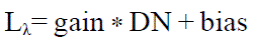
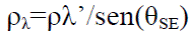
From Eq 1, gain is the slope and bias is the intercept of the equation of spectral radiance conversion/DN; DN is the digital number. From Eq 2, the estimated ref lectance at top of the atmosphere is obtained; π is Sr (white Lambertino hypothesis; Lλ is the product from Eq. 1; d2 is the distance from Earth to the Sun in astronomical units; ESUNλ, is solar spectral irradiance at top of atmosphere; θS is the solar zenith angle. This equation is for Landsat 5 TM images. From Eq. 4, the reflectance value at top of atmosphere is obtained; Mp is the rescaling multiplicative factor and is specific for each band; Qcal is the DN value; Ap, is the additive rescaling factor and it specific for each band. Equation 5 is a correction equation of ref lectance by the solar local angle. ρλ’ is the product from Eq. 4; θSE is the local elevation angle of the sun; is located at the center of the scene.
Although the result from the equations used is an estimate of the reflectance value, it must perform the calculations separately as each source sensor has its own setting parameters. Eq. 1 and 2 correspond to data structure of 8-bit from Landsat 5 TM images, while Eq. 3, 4 and 5 are suitable for data processing at 16 bits from Landsat 8 OLI.
Salinity index was obtained according to equation 6.
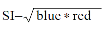 6)
6)
From Eq 6, SI is the index value; blue is the blue band (0.45.0.51μm) and red (0.64 to 0.67 μm) is the red region from the electromagnetic spectrum.
As alternative to class intervals proposed by Shannon (1997), to categorize soil salinity, the following intervals are proposed: <16 dS m-1, moderately saline; <16-20> dSm-1 saline; > 20 dSm-1, highly saline.
Data analysis
For statistical analysis of the data a representative sample of 1 800 ha of land, equivalent to 20 000 coordinate pairs, which are the centroid of an equal number of pixels of Landsat image were obtained. As mask analysis, was used the land use serial vector VI from the National Institute of Statistics and Geography (INEGI). Due to the amplitude in class number, the number of strata was reduced to ten: irrigated (riego), rainfed (temporal), grassland (pastizal), bare soil (s_desnudo), scrub (matorral), mesquite (mezquite), dune (duna), body water (cpo_agua), human settlements (ah) and halophyte vegetation (v_halofita).
Statistical analysis was performed using ANOVA (analysis of variance) single factor; to explore differences between groups Tukey 0.05 was used. This is a test that can be used when required to compare each group with the rest and the number of groups is high (more than 6).
Results and discussion
Mapping soil salinity
Figure 1 shows the sequence of thematic maps showing spatial and temporal variation in the study area according to salinity index.
To highlight from Figure 1, images A and B correspond to the beginning of the study (1995) and as shown in Figure 2 (zooming), salt content in the soil decreases considerably from one date to another in agriculture land; it shows that natural vegetation keeps its salinity level. The difference between one image and another is one month and it seems that the crops have been removed from ground cover and it is evident the decline of soil salinity value; this can be distinguished by the predominance of orange tones in the image. The presence of extreme values in the image (blue tones) can be considered aberrant (implausible data) and can be attributed to the presence of clouds.

Figures E and F from Figure 1 correspond to the last date from the data series (November 2015). A better definition in land use is observed, which facilitates photo interpretation analysis of the image. Table 1 shows the descriptive data of the sample data is displayed.

From Table 1, the column headings are: n is the number of coordinate pairsperstratum of land use; A 01 is the image date, April 17, 1995; A02, May 19, 1995; X02, June 6, 2000; C00, November 22, 2005; and OLI, November 02, 2015. The value presented corresponds to the estimated average value of salt content in the soil (dSm-1). For convenience, hereinafter, the image date will be referred with these acronyms.
An important aspect to observe from the data series was aimed at identifying land use substrate where changes in salinity condition were more evident (Figure 2).
The most notable aspect from Figure 3 is the disappearance of the "moderate" and "saline" class, virtually since 1995, starting date when gradually decreased till disappearance in 2015. It is noted that the substrate is higher dynamism is agricultural independently if it is under irrigation or rainfed. Another aspect that stands out is the consistency in SI values of one image to another till the most recent (OLI). From this perspective, it is identified that in substrates without vegetation (dunas, s_desnudo, and ah), and pastizal, where variations were not so noticeable.
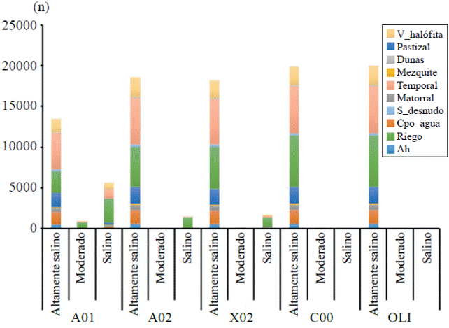
Figure 3 Number of pixels of the sample with changes in location of land use substrate according to the SI index value
The trend that data suggests is an increase of salt content in the soil. This is a warning point especially for agricultural areas under irrigation and rainfed. According to Fernández-Mata et al. (2014) the increase of salts in the soil limits agricultural activity in large land extension causing a decrease in soil capacity and low crop yields; in this regard producers, scientists and decision makers should join efforts and develop research proposals projecting a program for mitigation measures to reverse this trend. The biggest concern is that the more saline the soil plants are less capable to absorb water. The reason is simple, as salinity levels in the soil are high, the water present in the roots returns to the ground and the plant does not have the capacity to absorb it; grown plants will eventually wither and die, regardless of the amount of water being supplied.
Data analysis
ANOVA test was significant (p< 0.01) for land use. Figure 4 shows the distribution of means by sampling date per land use stratum.

In Figure 4, can be highlighted the explosive increase in soil salinity from 2000 to 2015 in all strata. Three points to highlight from the graph are: 1) agricultural substrate (irrigation and rainfed) shows the growth rate in higher salinity; this can be interpreted as own practices applied by producers, inherent to the production system; and 2) the stability of some land uses in those despite the increase in soil salinity, remain stable; these are: scrub, grassland and mesquite. Table 2 shows the results from the homogeneous groups test Tukey (0.05).
Table 2 Tukey test for homogeneous groups on sample data.

El valor mostrado es el promedio. Los caracteres en negritas corresponden con el valor mínimo y los subrayados en itálicas al valor máximo de SI (dSm-1). El número de grupos significativamente diferentes es el que se reporta en la fila debajo del valor de SI, deben leerse en sentido vertical, por fecha de la imagen.
From Table 2, specifically strata where higher salt content was observed are those lacking vegetation. The lowest values were found for strata "riego" (in April and May 1995) and "mesquite" (in April 1995). As mentioned above, water use and management and technological packages could be the cause explaining these values in "irrigation" class. For mesquite, it is remarkable the parallelism with the substrate "matorral" in salt content in the soil. Jarrell and Virginia (1984) reported that mesquite root systems are well adapted to grow in areas where water source is mostly underground. Also mention that mesquite is able to grow and flourish in saline soils higher than 20 dSm-1 and its roots can take saline water of up to 28 dSm-1. For scrub community, numerous reports generally highlight that this biotic community is tolerant to high salinity in water and saline soils. Our results seem to support these findings and suggest that these biotic communities can survive to more saline conditions than those reported by these authors. However, our study is not conclusive and demands more attention with the approach of new research questions that include georeferenced of specific areas and spatially continuous of sites with these biotic communities.
Conclusions
Through a spectral index it was proven the pattern of spatial and temporal variation of soil salinity in a multi-fragmented region by the spatial frontier of land use. With the techniques of data analysis applied obtained evidence that salinity is increasing in all land use classes. Hence the desirability of carrying the delineation of a strategic mitigation plan in which considers reversing the trend of increasing soil salinity, as this condition puts at risk agricultural production, soil conservation and overall sustainability of ecosystem. The major topics that this strategic plan should include are: promoting improved drainage systems, promotion among producers for incorporation of crop residues into the soil, use of drought tolerant species, and productive reconversion.
Literatura citada
Allbed, A. and Kumar, L. 2013. Soil salinity mapping and monitoring in arid and semi-arid regions using remote sensing technology: a review. Advances in remote sensing. 2:373-385. [ Links ]
Igartua, E.; Gracia, M. P. and Lasa, J. M. 1994. Characterization and genetic control of germination, emergence responses of grain sorghum to salinity. Euphytica. 76(3):185-193. [ Links ]
Maiti, R. K. and de la Rosa, L. A. 1994. Evaluation of several sorghum genotypes for salinity tolerance. International Sorghum and Millets Newsletter, 35:121. [ Links ]
Macharia, J. M.; Kamau, J.; Gituanja, J. N. and Matu, E. W. 1994 Effects of sodium salinity on seed germination and seedling root and shoot extension of four sorghum [Sorghum bicolor (L.) Moench] cultivars. International Sorghum and Millets Newsletter. 35:124-125. [ Links ]
Richards, L. 1954. Diagnosis and improvement of saline and alkali soils. Soil Science. 78(2):154. [ Links ]
Rhoades, J. and Loveday, J. 1990. Salinity in irrigated agriculture. In: Stewart, B. A. and Nielsen, D. R. (Eds.). American Society of Civil Engineers, Irrigation of Agricultural Crops. 30:1089- 1142. [ Links ]
Shannon, M.C. 1997. Adaptation of plants to salinity. Advances in Agronomy. 60:75-120. [ Links ]
Shrestha, D. P. and Farshad, A. 2008. Chapter 13. Mapping salinity hazard: an integrated application of remote sensing and modeling-based techniques. In: Metternicht, G. and Zinck, J. A. (Eds.). Remote sensing of soil salinization: Impact on Land Management, CRC Press, Boca Raton, 257 p. [ Links ]
Zhu, J. K. 2001 Plant salt tolerance. Trends in Plant Science. 6(2):66-71. [ Links ]
Almodares, A.; Hadi, M. R. and Dosti, B. 2008a. The effects of salt stress on growth parameters and carbohydrates contents in sweet sorghum. Res. J. Environ. Sci. 2(4):298-304. [ Links ]
Ghabour, T. and Daels, L. 1993. Mapping and monitoring of soil salinity of ISSN. Egyptian J. Soil Sci. 33(4):355-370. [ Links ]
Rouse, J. W.; Hass, R. H.; Schell, J. A. and Deering, D. W. 1973 Monitoring vegetation systems in the great plains with ERTS. Third ERTS Symposium. NASA SP-351.1:309-317. [ Links ]
Huete, A. R. 1988. A soil-adjusted vegetation index (SAVI). Remote Sensing of Environment, 25(3):295-309. [ Links ]
Khan, S. and Abbas, A. 2007. Remote sensing based modelling applications in land and water management: using remote sensing for appraisal of irrigated soil salinity. MODSIM 2007. International Congress on Modelling and Simulation. Modelling and Simulation Society of Australia and New Zealand. 343 p. [ Links ]
Fernández-Mata, I.; Rodríguez-Gamiño, M. L.; López-Blanco, J. y Vela- Correa, G. 2014. Dinámica de la salinidad de los suelos. Revista Didgital E-BIOS. 5(1):26-35. [ Links ]
Jarrel, W. M. y Virginia, R. A. 1984. Salt tolerance of mesquite. California Agriculture. 87 p. [ Links ]
Received: November 2015; Accepted: February 2016
 Este es un artículo publicado en acceso abierto bajo una licencia Creative Commons
