


Serviços Personalizados
Journal
Artigo
 texto em
  Inglês (pdf)
 Artigo em XML
 Referências do artigo
 Enviar este artigo por email
Indicadores
-
 Citado por SciELO
 -
 Acessos
Links relacionados
-
 Similares em
SciELO
Similares em
SciELO
Compartilhar

 Permalink
Revista mexicana de ciencias agrícolas
versão impressa ISSN 2007-0934
Rev. Mex. Cienc. Agríc vol.7 no.8 Texcoco Nov./Dez. 2016
Articles
Evaluation of agricultural-forestry sector for adaptation to climate change in the south-southeast of Mexico
1Campo Experimental Cotaxtla-INIFAP. Carretera Veracruz-Córdoba km 34.5. C. P. 94270. Medellín de Bravo, Veracruz. México Tel. 01 8000882222, ext. 87222. (inurreta.daniel@inifap.gob.mx; espinosa.jose@inifap.gob.mx; uresti.diana@inifap.gob.mx).
2Centro Nacional de Investigación Disciplinaria en Fisiología y Mejoramiento Animal- INIFAP. Carretera a Colón, km 1, CP. 76190. Ajuchitlán, Querétaro, México. Tel: 01 8000882222, ext. 80226.
Climate change will impact negatively the productivity of the agricultural-forestry sector, putting at risk food security. To develop plans for adaptation to climate change in these sectors, it is necessary to count with information on their capacity to adapt. This study aimed to develop a synthetic index of adaptability to climate change (ICA) at municipal level in eight representative basins from south-southeast of Mexico (Balsas-Mezcala, Grijalva-Concordia, Grijalva-Villahermosa, Laguna de Terminos, Nautla, Papaloapan, Tehuantepec, Yucatan). ICA was developed based on five sub-indexes: natural resources (RN), development of human capacities (DH), economic development (DE), infrastructure development (DI); technological development (DT), each sub index was assessed using different variables obtained from the characterization, at municipal level, from natural resources, socio-economic, technological and infrastructural aspects; the information used was obtained from different official sources, that was processed, analyzed and brought together in databases. Finally the ICA obtained for each municipality, was expressed cartographically. In the study area 255 municipalities have a low level of adaptation, 350 average level and only 19 a high level. Most municipalities with low ICA are in the mountains, while municipalities with high ICA contain cities, where high GDP increases DE and therefore ICA.
Keywords: cartography; databases; decision making; planning; synthetic index
El cambio climático impactará en forma negativa la productividad del sector agropecuario-forestal, poniendo en riesgo la seguridad alimentaria. Para elaborar los planes de adaptación al cambio climático de dichos sectores, es necesario contar con información sobre su capacidad de adaptación. El presente estudio, tuvo como objetivo desarrollar un índice sintético de capacidad de adaptación al cambio climático (ICA) a escala municipal en ocho cuencas representativas del sur-sureste de México (Balsas-Mezcala, Grijalva-Concordia, Grijalva-Villahermosa, Laguna de Términos, Nautla, Papaloapan, Tehuantepec, Yucatán). El ICA se desarrolló en función de 5 sub índices: recursos naturales (RN), desarrollo de las capacidades humanas (DH), desarrollo económico (DE), desarrollo de infraestructura (DI); desarrollo tecnológico (DT), cada sub índice se evaluó a través de diferentes variables obtenidas a partir de la caracterización, a escala municipal, de los recursos naturales, aspectos socioeconómicos, tecnológicos y de infraestructura; la información utilizada se obtuvo a partir de diversas fuentes oficiales, que se procesó, analizó y conjuntó en bases de datos. Finalmente el ICA obtenido para cada municipio, se expresó cartográficamente. En el área de estudio 255 municipios presentan un nivel de adaptación bajo, 350 un nivel medio y solo 19 un nivel alto. La mayoría de los municipios con nivel bajo de ICA se encuentran en lugares serranos, mientras que los municipios con un ICA alto contienen ciudades, en donde el alto PIB incrementa el DE y por lo tanto el ICA.
Palabras clave: bases de datos; cartografía, índice sintético, planeación, toma de decisiones
Introduction
The Intergovernmental Panel on Climate Change in 2007 confirmed that global warming is a fact due to anthropogenic causes (Solomon et al., 2007). The increase in population, the burning of fossil fuels, agriculture, deforestation and changes in land use for food production and urbanization, are the main sources of emissions of greenhouse gases (GHGs) such as carbon dioxide (CO2), methane (CH4) and nitrous oxide (N2O), at rates that are considered dangerous for the balance of the climate system, food security, ecosystem protection and sustainable economic development.
Solomon et al. (2007) reports that between the periods 1850 to 1899 and from 2001 to 2005 an increase in the average global temperature of 0.74 °C was recorded. Meehl et al. (2007) reports that for 2011-2030, 2046-2065 and 2080-2099 the average global temperature will increase by 1-2 °C, 3-4 °C and 4-7 °C, respectively, compared with temperatures in the period 1980-1999. in the subtropics areas there will be a reduction of up to 20% of rainfall (Solomon et al., 2007).
The impact in Mexico will be reflected by more intense and spaced rainfall, thus extreme events (heat waves, droughts, floods, hurricanes and tropical cyclones) of higher intensity (Meehl et al., 2007). The increase in temperature, reduction of rainfall and the presence of extreme events will have a negative impact on the productivity of agriculture, livestock and forestry sectors, putting food security and sustainable development at risk. With an increase of 3 °C (which is expected in the period 2040-2060), reductions in grain yield between 20 and 50% (Easterling et al., 2007) will be observed.
Mankind has always sought to adapt to the impacts of climate variability, using a wide range of technologies (Burton et al., 2006) in fact it can be said that human societies are inherently adaptive, responding to changes in the environment in search for subsistence (Engle, 2011). However, adaptation is a complicated process, where many times instead of mitigating the effects of disturbance phenomenon, these exacerbate (Barnett and O'Neill, 2010) and whose guidelines are highly influenced by social and cultural goals of the population (Adger et al., 2004). In addition to this, climate change presents new challenges beyond the adaptation range to traditional climate variability (Solomon et al., 2007).
Adaptation to climate change and risks posed, takes place in a social, economic, technological, biophysical and political context, which varies with time, location and sector; this complex mixture of conditions determines the capability of the systems to adapt (Smit and Pilifosova, 2007). The adaptation process consists of three main steps: assessing vulnerability to climate change, developing necessary capabilities at international, national and local level and promote adaptation measures, these steps are dynamic and interrelated.
The power of any system to deal with exposure and sensitivity against external adverse phenomenon depends on the extent in which can exploit its ability to adapt, either innate or developed (Tol, 2009). The capability to adapt to climate change, is the ability to design and implement effective adaptation strategies to respond to the growing threats of climate change, in order to reduce the probability of occurrence or the magnitude of the impact of negative phenomena; this process requires to use available information to face the future climate, including surprises (Brooks and Neil, 2005; Smit and Pilifosova, 2007). Increased resilience to climate change improves the opportunity of the systems to handle different ranges and magnitudes of impacts, providing resilience to the system (Engle, 2011).
Adaptation measures are those strategies that enable individuals or communities to cope and adapt to the impacts of climate change in specific areas (Nyong et al., 2007) and are a key factor to reduce the severity of the impact of change climate in food production (Easterling et al., 2007). According to Smit et al. (2007) adaptation measures to climate change can be classified according to several factors, however the most accepted classification is divided into autonomous and planned, autonomous implement on the go knowledge and technologies in response to changes and impacts, while planned include mobilization and operation of institutions, policies and programs to establish or reinforce favorable conditions for an effective adaptation (Adger et al., 2007).
It is necessary to implement both autonomous adaptation measures to prevent and reverse the negative impact of climate change, and planned measures of adaptation to increase the ability and build capacity and favorable conditions for an effective adaptation. Easterling et al. (2007), indicates that as the temperature increases, the efficiency of adaptation measures decreases till disappearance with increases of temperatures higher than 3 °C.
The ability to adapt is a necessary condition for the design and implementation of adaptation measures and depends upon the degree of economic, technological, human capabilities, infrastructure, governmental structures and equity measures (Smit and Pilifosova, 2001). For Yohe and Tol (2002), adaptive capacity is determined by eight factors: a) available technologies; b) availability of resources and access of the population to these; c) institutional structure; d) human capital; e) social capital; f) access to relevant information; g) ability of decision makers; and h) public perception of climate change and its local impacts.
South-southeast of Mexico is a region with contrasting soil, climate, orographic, political, economic, technological, human development and infrastructure; whose main activity is agriculture, livestock and forestry production (INEGI, 2014). Due to such conditions, it is expected that the impact of climate change will be irregular and severe in most vulnerable regions, jeopardizing food and livelihood of the people from this region, affecting the rest of the country. The use of adaptation measures could reduce the impact of climate change on productivity of the agricultural and forestry sector in this region. However, currently the degree of adaptability is unknown at municipal level in the southsoutheast region of Mexico. Therefore, this work generates a synthetic index at municipal level of the south-southeast region of Mexico, expressing the capability of adaptation to climate change, based on natural, economic, human, technological and infrastructure factors.
Materials and methods
Eight representative watersheds with soil, climate, orographic and land use from south-southeast of Mexico were selected: 1) Balsas-Mezcala, located in the state of Guerrero; 2) Grijalva-Concordia, located in the state of Chiapas; 3) Grijalva-Villahermosa, located in the state of Tabasco; 4) Laguna de Termino, located in the state of Campeche and Yucatán; 5) Nautla, located in the state of Veracruz; 6) Papaloapan, located in the states of Veracruz and Oaxaca; 7) Tehuantepec, located in the state of Oaxaca; and 8) Yucatán, located in the state of the same name. These basins were identified from the watershed map from CNA (2011) 1:250 000 scale.
Subsequently the municipalities contained in each basin were located and mapped, for which the ArcMap 9.3 software was used, overlaying a map of selected basins with the map of political division from INEGI (2011) 1:250 000 scale. When political municipal boundaries do not correspond with watersheds delimitation, the decision to consider the total area of the town was taken causing an increase in the study area.
The synthetic index of adaptability to climate change (ICA) was estimated using as basis information from a series of characterizations from the current state of the agricultural, livestock and forestry production sectors, thus socioeconomic conditions and prevailing natural resources in each municipality, the information for the characterization was collected from official sources, with which a database was integrated and generated five sub-indices: natural resources (RN), economic development (DE), human capacity development (DH), technological development (DT) and infrastructure development (DIAPF). These subindices were evaluated from variables that were formed with the parameters obtained from the characterization (Table 1 and 2).
Table 1 Conformation of socioeconomic and natural resources variables that integrate the synthetic index of adaptive capacity to climate change.
Notas: los ponderadores de cada subíndice y variables se presentan en corchete [ ].
Table 2 Classification of the parameters used to form climate and soil parameters.
| Parámetros | Valores | Calificación | Parámetros | Valores | Calificación |
| Temperatura promedio (°C) | 9-18 ó 28-30 | 2.5 | Precipitación pluvial (mm) | 300-500 | 2.5 5 |
| 18-22 ó 27-28 | 5 | 500-1 000 | 2.5 5 | ||
| 22-24 ó 26-28 | 7.5 | 1 000-1 500 | 7.5 | ||
| 24-26 | 10 | 1 500-6 000 | 10 | ||
| Radiación solar (MJ m-2 ciclo-1) | 2 000-3 000 | 7.5 | Profundidad del suelo (cm) | 7-30 | 2.5 |
| 30-50 | 5 | ||||
| 3 000-4 500 | 10 | 50-70 | 7.5 | ||
| 70-320 | 10 | ||||
| Textura (%) de arcilla, limo y arena | Arcilla, arena | 3 | Franco arcillo limoso, franco arcilloso, franco arcillo arenoso, franco arenoso Franco, franco limoso y limo | 8 | |
| Arcillo limoso, arcillo arenoso y arenoso franco | 6 | 10 | |||
| Contenido de materia orgánica (%) | pH | 8.5-10.5 | 2 | ||
| 0.1-2 | 3 | 4-5 | 4 | ||
| 2-4 | 7 | 5-6 | 6 | ||
| 4-40 | 10 | 6-6.5 ó 7.5-8.5 | 8 | ||
| 6.5-7.5 | 10 | ||||
| Pendiente del terreno (%) | >30 | 2 | 3-8 | 8 | |
| 15-30 | 4 | 0-3 | 10 | ||
| 8-15 | 6 | ||||
The parameters used for variables DE, DH, DT and DIAPF were obtained from official sources as SIAP (2016), INEGI (2011), CONAFOR (2016), SNIIM (2016), CONAPO (2014), CONEVAL (2014). Due to the information required to develop the RN sub-index, there was no information available at municipal level, so it was necessary to estimate the parameters, as described below:
Climate parameters were obtained from 335 meteorological stations from SMN. Using ArcGIS 9.3, the centroid of each municipality was located and identified the closest weather station to it. Climatic parameters were considered from monthly average statistics compiled with measured a daily data for each station, it is noteworthy that only stations with complete information of more than 10 years were used.
Soil parameters were obtained using the information contained in 1143 agrologic profiles reported by INEGI. With this information, the typical profile for each soil subclass (FAO-UNESCO classification) present in the study area was created. Subsequently, because the spatial distribution of soil subclasses is independent of municipality’s political division, the municipality was rated by weighting the value of each subclass according to the surface occupied by this.
The parameters of water resource, given the limited availability of information, were obtained at scale of the hydrological region, assigning each municipality the corresponding value to the hydrologic region in which is located.
For this it was necessary to determine which hydrologic region belonged to each of the municipalities in the area studied conducting an overlapping of municipal maps from INEGI (2011) and hydrologic regions from CNA (2011), using the ArcGIS 9.3 software. Parameters used were “water available per capita” and “pressure on water resources”. The first is the ratio of renewable water in hm3 year-1 (total natural runoff plus the average total aquifer recharge), among the total population of the hydrologic region and the second is the ratio of concessioned volume (sum of total consumptive water use) between renewable water hm3 year-1.
Once identified all the required parameters to develop the five sub-indexes, a score on a scale of 1 to 10 were assigned. In the case of sub-indices RN, DE and DH, the capacity of these to contribute to production of agricultural, livestock and forestry sectors were considered and as for variables DT and DIAPF were classified with the same score of 1 to 10 according to the proportion in percentage of production units that each of corresponding technological and infrastructure elements showed.
Then the value of each of the five sub-indices was calculated and estimated the ICA value for each municipality:
Finally, municipalities were classified according to ICA into three levels: low ≤ 5; average: 5.1 - 6.5 and high: ≥ 6.6.
Results and discussion
Of variables considered in the study, the ones with higher relation to agriculture and climate change sector are natural resources and this is because since planting is carried out or a livestock species born, both plants and animals are subject to asynchronous variations of the elements comprising weather and weather is the main factor of agricultural productivity (Falasca and Ulberich, 2006). For the specific case of agricultural and forestry, soil provides to the plant anchor and is their main supply of nutrients and water, reason why there is a close relationship between soil quality and agricultural and forest productivity (Lal, 2006). Crops and livestock species are highly dependent on water availability; on the one hand the biological need of plants and on the other by interaction with fundamental hydrological processes (Rockström et al., 2009). Therefore these three factors were considered to form RN variable and the grade assigned in this study are presented in Tables 2 and 3, where optimal conditions reach a value of 10.
Table 3 Classification of the parameters used to form the parameters related to water resources.
| Parámetros | Valores | Calificación | Parámetros | Valores | Calificación |
| Agua disponible per cápita (m3 hab-1 año-1) | 1 900-22 400 | 10 | Presión sobre el recurso hídrico (%) | 10-50 | 4 |
| 5-10 | 8 | ||||
| 1.4-5 | 10 |
There are also socioeconomic factors that determine the ability to adapt to climate change; among these are economic development, social capital, technology and infrastructure, among others (McCarthy et al., 2001). DE and distribution of goods are of great importance to agricultural productivity (Takeshima and Yamauchi, 2012; Hichaambwa and Jayne, 2014) and to improve adaptation capability to climate change (Adger et al., 2007), mainly because it favors access to infrastructure and technology, that is why indicators such as gross domestic product (GDP), poverty rate and degree of marginalization (CONAPO, 2013) present a better behavior, contributing to the production units placed in municipalities with greater economic development, which will help them to be better adapted to climate change, so the higher scores of these indicators were assigned a value of 10 (Table 4).
Table 4 Scoring of the parameters used to form the variable economic development.
| Parámetros | Valores | Calificación | Parámetros | Valores | Calificación |
| Producto interno bruto (dólares año-1) | 1 467-3 | 2 | Grado de marginación | Muy bajo | 2 |
| 3 247-6 494 | 4 | Bajo | 4 | ||
| 6 494-9 741 | 6 | Medio | 6 | ||
| 9 741-12 988 | 8 | Alto | 8 | ||
| 12 988-16 235 | 10 | Muy alto | 10 | ||
| Pobreza (%) | 80-100 | 2 | Pobreza (%) | 40-60 | 6 |
| 60-80 | 4 | 20-40 | 8 | ||
| 0-20 | 10 |
Regarding to social capital, to count with qualified young workforce increases productivity in the primary sector (Appleton and Balihuta, 1996) and therefore the ability to adapt to climate change (Adger et al., 2004); also gender equality, is a desirable characteristic that gives societies flexibility to perform different activities and also increases the ability to adapt to climate change (Bee et al., 2013). Considering this, to form DH, it was formed with the proportion of age and gender of the population and educational level, and as in the case of natural resources and economic development, the score of 10, was assigned to the best performing indicators (Table 5)
Table 5 Scoring of the parameters used to form the human development variable.
| Parámetros | Valores | Calificación |
| Proporción de géneros (núm. de hombres núm. de mujeres-1) | 0.61-0.71 ó 1.21- 1.4 | 4 |
| 0.71-0.8 ó 1.21-1.3 | 6 | |
| 0.81-0.9 ó 1.10-1.2 | 8 | |
| 0.91-1.1 | 10 | |
| Proporción de edades | < 5 años | 2 |
| > 60 años | 4 | |
| 6-14 años | 6 | |
| 25-59 años | 8 | |
| 15-24 años | 10 | |
| Grado de escolaridad promedio | 1, 2, …. , 10 | 1, 2, … , 10 |
| Profesionistas (%) | 0-0.05 | 2 |
| 0.06-0.1 | 4 | |
| 0.11-0.15 | 6 | |
| 0.16-0.2 | 8 | |
| 0.21-0.25 | 10 | |
| Tasa de alfabetización | 73-80 | 2.5 |
| 81-87 | 5 | |
| 88-94 | 7.5 | |
| 95-100 | 10 |
In the agricultural, livestock and forestry sector, adaptation requires the use of appropriate practices to cope with variable and harsh environmental conditions. To adopt new agricultural practices requires access to new technologies, modify existing ones, and count with additional capacity in the field, political and scientific levels to implement such measures. Productivity increase in the primary sector of economy depends on good rural infrastructure, the proper functioning of national markets, presence of adequate institutions and access to appropriate technology (Nick et al., 2004; Andersen and Shimokawa, 2007). Infrastructure development that supports the agricultural, livestock and forestry sectors, not only helps to increase the productivity of these, but improves the ability to distribute their products, process them and give them added value. So, the presence of public works is also a factor that increases the adaptability to climate change (Brooks et al., 2005; Jacinthe and Rattan, 2006).
By analyzing and graphing ICA in the basins under study, it was found that 255 municipalities (4 196 677 ha) have low adaptive capacity, 350 municipalities (22 030 402 ha) an average adaptive capacity and 19 municipalities (2 242 134 ha) high adaptive capacity. In percentage, 40% of the area has low adaptability to climate change, 56% average capacity and only 3% has high adaptive capacity (Figure 1).
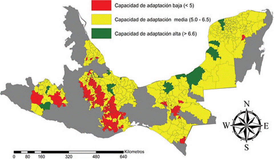
Figure 1 ICA values for the municipalities of eight representative basins from south-southeast of Mexico
Table 6 shows the area in percentage and number of municipalities in each classified basins according to their ability to adapt, as can be seen the Balsas Mezcala, and Papaloapan basins are those with the highest percentage of area with low adaptation ability, Papaloapan also has a greater number of municipalities within this class; at the opposite end is the basin of Terminos where 19% of its surface has high adaptive capacity, however this whole area corresponds to a single municipality.
Table 6 Surface in percentage and number of municipalities in each basin classified by their ability to adapt to climate change.
| Cuenca | Superficie con capacidad de adaptación baja en porcentaje (núm. de municipios) | Superficie con capacidad de adaptación media en porcentaje (núm. de municipios) | Superficie con capacidad de adaptación alta en porcentaje (núm. de municipios) | Total en ha X 1 000 (núm. de municipios) |
| Balsas Mezcala | 36%(13) | 54%(21) | 10%(2) | 2 665(36) |
| Grijalva Concordia | 5%(6) | 95%(22) | 0%(0) | 2 221(28) |
| Grijalva | 6%(21) | 88%(38) | 6%(3) | 4 549(62) |
| Villahermosa | ||||
| Nautla | 4%(5) | 96%(30) | 0%(0) | 982(35) |
| Papaloapan | 31%(152) | 65%(115) | 4%(8) | 6 087(275) |
| Tehuantepec | 73%(55) | 27%(13) | 0%(0) | 1 129(68) |
| Términos | 0%(0) | 81%(6) | 19%(1) | 4 547(7) |
| Yucatán | 2%(3) | 89%(105) | 9%(5) | 6 289(113) |
Conclusions
Most municipalities with low ICA level are in in highland areas, while municipalities with a high ICA level are in extensive municipalities and large cities; this is mainly because they have a high DE, which translates into higher ICA. Since very few municipalities have a high ICA, it is suggested to take measures for the sake of increasing it and thereby address the challenges posed by climate change.
Literatura citada
Adger, W. N.; Nigel, W. A. and Tompkins, E. L. 2004. Successful adaptation to climate change across scales. Global Environ. Change. 15:77-86 [ Links ]
Adger, W. N.; Agrawala, S. S.; Mirza, M. M. Q.; Conde, C.; O’Brien, K.; Pulhin, J.; Pulwarty, R.; Smit, B. and Takahashi, K. 2007. Assessment of adaptation practices, options, constraints and capacity. In: climate change 2007: impacts, adaptation and vulnerability. Contribution of Working Group II to the Fourth Assessment Report of the Intergovernmental Panel on Climate Change. Parry, M. L.; Canziani, O. F.; Plutikof, J. P.; Van der Linden P. J. and Hanson, C. E. (Eds.). Cambridge University Press, Cambridge, UK. 717-740 pp. [ Links ]
Andersen-Pinstrup, P. and Shimokawa, S. 2007. Do poverty and poor health and nutrition increase the risk of armed conflict onset? Food Policy. (33):513-520 [ Links ]
Appleton, S. and Balihuta, A. 1996. Education and agricultural productivity: evidence from Uganda. Centre for the Study of African Economics. Oxford, U. K. 32 p. [ Links ]
Barnett, J. and Saffron, O. 2010. Editorial. Global Environmental Change. 20:211-213. [ Links ]
Bee, B.; Biermann, M. and Tschakert, P. 2013. Gender, development, and rights-based approaches: lessons for climate change adaptation and adaptive social protection. Josef Korbel School of International Development, University of Denver, USA. 98 p. [ Links ]
Brooks, N. and Neil, A. W. 2005. Assessing and enhancing adaptive capacity. Tyndall Centre for Climate Change Research. UK. Technical Paper Number 7. 18 p. [ Links ]
Burton, I.; Diringer, E. and Smith, J. 2006. Adaptation to climate change: international policy options. Pew Center on Global Climate Change. Arlington, USA. 36 p. [ Links ]
Comisión Nacional del Agua (CAN). 2011. Estadísticas del agua en México, edición 2011. Coyoacán, D. F. 185 p. [ Links ]
CONAFOR. 2016. Evaluación del borrador de la Iniciativa de Reducción de Emisiones. Ciudad de México. 354 p. [ Links ]
CONAPO. 2014. La situación demográfica de México 2014. Ciudad de México. 267 p. [ Links ]
CONEVAL. 2014. Resultados de la medición de pobreza 2014. Ciudad de México. 30 p. [ Links ]
Easterling, W. E.; Aggarwal, P. K.; Batima, P.; Brander, K. M.; Erda, L.; Howden, S. M.; Kirilenko, A.; Morton, J.; Soussana, J. F.; Schmidhuber J. and Tubiell, F. N. 2007. Food, fibre and forest products. In: Climate Change 2007: impacts, adaptation and vulnerability. Contribution of Working Group II to the Fourth Assessment Report of the Intergovernmental Panel on Climate Change. Parry, M. L.; Canziani, O. F.; Plutikof, J. P.; Van der Linden P. J. and Hanson, C. E. (Eds.). Cambridge University Press, Cambridge, UK. 273-313 p. [ Links ]
Engle, N. L. 2011. Adaptive capacity and its assessment. Global Environ. Change. 21:647-656. [ Links ]
Falasca, S. and Ulberich, A. 2006. Cultivos alternativos para la producción de biocombustible en el área semiárida Argentina. Rev. Geog. (140):135-150. [ Links ]
Hichaambwa, M. and Jayne, T. S. 2014. Poverty reduction potential of increasing smallholder access to land. Indaba Agricultural Policy Research Institute. Working Paper No. 83. Lusaka, Zambia. 33 p. [ Links ]
INEGI. 2011. Anuario estadístico de los estados unidos mexicanos, Edición 2011. INEGI. Aguascalientes, Aguascalientes. 55 p. [ Links ]
INEGI. 2014. Encuesta Nacional Agropecuaria 2014. INEGI. Aguascalientes, Aguascalientes. 547 p. [ Links ]
Jacinthe, P. and Rattan, L. 2006. Erosion and carbon dioxide. Encyclopedia of Soil Science. 2ª Edición. USA. 468-472 pp. [ Links ]
Lal, R. 2006. Enhancing crop yields in the developing countries through restoration of soil organic carbon pool in agricultural lands. Land Degrad. & Dev. 17:197-209. [ Links ]
McCarthy, J. J.; Canziani, O. F.; Leary, N. A.; Dokken, D. and Kasey, S. W. 2001. Climate change 2001: impacts, adaptation, and vulnerability. Contribution of Working Group II to the Third Assessment Report of the Intergovernmental Panel on Climate Change. Published for the Intergovernmental Panel on Climate Change. Cambridge, U. K. 75 p. [ Links ]
Meehl, G. A.; Stocker, T. F.; Collins, W. D.; Friedlingstein, P.; Gaye, A. T.; Gregory, J. M.; Kitoh. A.; Kanutti, R.; Murphy, J. M.; Noda, A.; Raper, S. C. B.; Watterson, I. G.; Weaver, A. J. and Zhao, A. C. 2007. Global climate projections. In: Climate Change 2007. The Physical science basis. Contribution of Working Group I to the Fourth Assessment Report of the Intergovernmental Panel on Climate Change. Solomon, S. D.; Qin, M.; Manning, Z.; Chen, M.; Marquis, K. B.; Averyt, M. Tignor and Miller, H. L. (Eds.). Cambridge University Press, Cambridge, UK and New York, NY, USA. 747-845 pp. [ Links ]
Nick, B.; Neil, A. N. and Mick, K. P. 2005. The determinants of vulnerability and adaptive capacity at the national level and the implications for adaptation. Global Environ. Change (15):151-163. [ Links ]
Nyong, A.; Adesina, F. and Osman, E. 2007. The value of indigenous knowledge in climate change mitigation and adaptation strategies in the African Sahel. Mitig Adapt Strategies Glob Chang. (12):787-797. [ Links ]
Rockström, J.; Steffen, W.; Noone, K.; Persson, Å.; Chapin, F. S.; Lambin, E. F.; Lenton, T. M.; Scheffer, M.; Folke, C.; Schellnhuber, H. J.; Nykvist, B.; de Wit, C. A.; Hughes, T.; van der Leeuw, S.; Rodhe, H.; Sörlin, S.; Snyder, P. K.; Costanza, R.; Svedin, U.; Falkenmark, M.; Karlberg, L.; Corell, R. W.; Fabry, V. J.; Hansen, J.; Walker, B.; Liverman, D.; Richardson, K.; Crutzen, P. and Foley, J. A. 2009: a safe operating space for humanity. Nature. (461):472-475 [ Links ]
SIAP. 2015. Sistema de Información Agroalimentaria de Consulta (SIACON). Secretaría de Agricultura, Ganadería, Desarrollo Rural, Pesca y Alimentación SAGARPA). http://www.siap.gob.mx/SIACON. [ Links ]
Smit, B. and Pilifosova, O. 2007. Adaptation to climate change in the context of sustainable development and equity. In: Climate Change 2007: impacts, adaptation and vulnerability. Contribution of Working Group II to the Fourth Assessment Report of the Intergovernmental Panel on Climate Change. Parry, M. L.; Canziani, O. F.; Plutikof, J. P.; Van der Linden, P. J. and Hanson, C. E. (Eds.). Cambridge University Press, Cambridge, UK. 877-912 pp. [ Links ]
SNIIM. 2016. Mapa del sitio web del SNIIM. http://www.economia-sniim.gob.mx/. [ Links ]
Solomon, S.; Qin, D.; Mannering, M.; Alley R., B.; Berntsen, T.; Bindoff N., L.; Chen, Z.; Chidthaisong, A.; Gregory, J. M.; Hegerl G., C.; Heimann, M.; Hewitson, B.; Hoskins, B. J.; Joos, F.; Jouzel, J.; Kattsov, V.; Lohmann, U.; Matsuno, T.; Molina, M.; Nicholls, N.; Overpeck, J.; Raga, G.; Ramaswamy, V.; Ren, J.; Rusticucci, M.; Somerville, R.; Stockeer T., F.; Whetton, P.; Wood R. A. and Wratt, D. 2007. Technical summary. In: Climate Change 2007. The Physical Science Basis. Contribution of Working Group I to the Fourth Assessment Report of the Intergovernmental Panel on Climate Change. Solomon, S.; Qin, D.; Manning, M.; Chen, Z. Marquis, M.; Averyt, K. B.; Tignor, M. and Miller, H. L. (Eds.). Cambridge University Press, Cambridge, UK and New York, NY, USA. 19-91 pp. [ Links ]
Solomon, S.; Qin, D.; Manning, M.; Marquis, M.; Averyt, K.; Tignor, M.; Miller, H. and Chen, Z. Climate Change 2007: the physical science basis. Cambridge University Press, Cambridge, UK and New York, NY, USA. 9 p. [ Links ]
Takeshima, H. and Yamauchi, F. 2012. Risks and farmers' investment in productive assets in Nigeria. Agric. Econ. 42(2):143-153. [ Links ]
Tol, R. 2009. The economic effects of climate. J. Econ. Perspec. 23(2):29-51. [ Links ]
Yohe, G. W. and Tol, R. 2002. Indicators for social and economic coping capacity- moving towards a working definition of adaptive capacity. Global Environ. Change. 12(1):25-40. [ Links ]
Received: July 2016; Accepted: October 2016
 Este es un artículo publicado en acceso abierto bajo una licencia Creative Commons
