


Serviços Personalizados
Journal
Artigo
 texto em
  Inglês (pdf)
 Artigo em XML
 Referências do artigo
 Enviar este artigo por email
Indicadores
-
 Citado por SciELO
 -
 Acessos
Links relacionados
-
 Similares em
SciELO
Similares em
SciELO
Compartilhar

 Permalink
Revista mexicana de ciencias agrícolas
versão impressa ISSN 2007-0934
Rev. Mex. Cienc. Agríc vol.7 no.2 Texcoco Fev./Mar. 2016
Articles
Determining the suitability of the land for maize by multi-spatial analysis in the State of Mexico
1Instituto Nacional de Investigaciones Forestales, Agrícolas y Pecuarias. Carretera Toluca-Zitácuaro, km 4.5. Vialidad Adolfo López Mateos, Colonia San José Barbabosa; Zinacantepec, Estado de México. C. P. 51350. Tel: 722 278-43-31.
2Laboratorio de Análisis Socioterritorial. Universidad Autónoma Metropolitana Cuajimalpa. Av. Vasco de Quiroga 4871, Col. Santa Fe Cuajimalpa, Ciudad de México C. P. 05348. (gcruzbel07@gmail.com).
3Instituto Nacional de Investigaciones Forestales, Agrícolas y Pecuarias. Centro Nacional de Investigaciones Disciplinaria en Conservación y Mejoramiento de Ecosistemas Forestales. Av. Progreso No. 5, Barrio de Santa Catarina, Del. Coyoacán. C. P. 04010. México, D. F.
The maize is the most widely consumed grain worldwide, to feed the population, livestock and industry; however, production and yields are decreasing day; therefore, it is essential to the identification and delimitation of areas with potential for development and production of maize to help meet the demand for grain. The objective of this research was to generate and implement a methodology for multi-criteria analysis as an alternative for zoning and delimitation of areas with aptitude for maize. The work was done for the State of Mexico. The information climate, soil and topography, where each variable is given a numerical value, according to the influence they have on the adaptation, development and yield of maize was used. The results show that the State of Mexico has 471 902 and 244 718 has very good and good productivity for rainfed maize. The variables that have a greater say in defining adaptation of maize are temperature, altitude, rainfall and soil types.
Keywords: demarcation; identification; production potential and zoning
El maíz es el grano de mayor consumo a nivel mundial, para la alimentación de la población, el ganado y en la industria; sin embargo, su producción y rendimientos son cada día menores; por lo tanto, es indispensable la identificación y delimitación de áreas con potencial para el desarrollo y producción del maíz para ayudar a satisfacer la demanda de este grano. El objetivo de esta investigación fue generar y aplicar una metodología de análisis multicriterio como una alternativa para la zonificación y delimitación de las zonas con aptitud para maíz. El trabajo se realizó para el Estado de México. Se utilizó la información de clima, suelo y fisiografía, donde a cada variable se le dio un valor numérico, según la influencia que tienen en la adaptación, desarrollo y rendimiento del maíz. Los resultados muestran que el Estado de México presenta 471 902 y 244 718 ha de muy buena y buena productividad para maíz de temporal. Las variables que tienen un mayor peso en la definición de la adaptación del maíz son la temperatura, altura, precipitación y tipos de suelos.
Palabras clave: delimitación; identificación; potencial productivo y zonificación
Introduction
Maize, wheat, rice, potatoes and beans are the staple food of the world population; of these crops, maize is the most widely planted worldwide and increased consumption by the population (Nadal and Wise, 2005; Barros, 2009; Paredes et al., 2009; FAO, 2011).
Currently in Mexico, as in other parts of the world, there is a food crisis, which is derived from the application of inappropriate technologies and poor selection of cultivation sites. For example, the average yield of maize in the world is 4.4 t ha-1 and Mexico reached only 2.5 t ha-1, although there are regions where the average yield exceeds eight tonnes under rainfed conditions (Romero and Puyana, 2004). The problem is the poor selection of potential areas and the implementation of inappropriate technologies; therefore, the development and implementation of scientific knowledge to solve these problems is needed. One way to achieve this is through the creation and implementation of methodologies to identify areas with suitability for cultivation of maize.
These methodologies should consider both crop requirements and the particular characteristics of the environment, to ensure proper use of the soil with high production and less impact on the environment (Perales, 2009; UCCS, 2009). In this regard the decision makers in the agricultural sector require studies on the ability of the land to plant crops in order to implement regional development programs to boost production and help the capitalization of rural producers (Jordan, 2008; Stuart and Emerson, 2009). In particular, Osorio et al. (2012) and Trueba (2012) conclude that there is a continuing demand for production technology and locating new areas for maize production in Mexico.
For the evaluation of the land, there are qualitative methods, rates of productivity and mathematical simulation models, which can be used separately or combined (Van Lanen et al., 1992). Among the methodologies for identifying and delimiting potential for crop development, highlight the areas of agro-ecological zoning (FAO, 1978; FAO, 1981; FAO, 1997; IIASA/FAO, 2012), the agronomic provinces rainfed maize (Turrent, 1986; Turrent et al., 1992; Turrent, 2009) and the determination of the productive potential of plant species (Medina et al., 1997).
The methodology of FAO is to review the climate, soil and management practices. The agro-ecological zones are defined as those which have similar combinations of climate, soil and the same biological-physical potential for agricultural production (FAO, 1981; FAO, 1985; FAO, 1997; IIAS/FAO, 2012). Parra (1989) mentions that its importance lies in obtaining data on the potential surface from the point of view of climate and soil for crop production.
Meanwhile, Turrent (1986), Turrent et al. (1992) and Turrent (2009) propose a methodology for the identification and delineation of the agricultural provinces for maize under rainfed conditions, which is based on the quotient resulting from dividing the evaporation of rainfall between period june to september and soil depth. It was applied at national level and for the State of Mexico.
Finally, the National Institute of Forestry, Agriculture and Livestock (INIFAP) proposed methodology to determine the production potential of plants and was one of the first attempts to define potential areas for cultivation (INIFAP, 1995). In this line Medina et al. (1997) formulated another methodology to determine the productive potential of plant species in Mexico, which consists of modeling with geographical data on climate, soil and topography, according to crop requirements.
Decision theory is an approach widely used in environmental sciences, such as: environmental impact assessment, projects of regional development and territorial planning (Valerie y Steward, 2002; García, 2004a). Romero (1993) mentions that the decision-making processes traditionally rely on techniques that seek feasible solutions which have a higher degree of accuracy. These techniques include multi-criteria analysis, which helps decision makers assess the value judgments of experts to systematically analyze complex problems by identifying the decision alternatives, and the criteria and their importance (weight) in the evaluation is performance alternatives to meet the desired objective. These methods mathematically combine the criteria and their weights to help in selecting the most desirable alternative (Partovi and Hopton, 1994; Malczewski, 1999; Kiker et al., 2005; Malczewski, 2006).
Multi-criteria analysis is a process of continuous and cyclical learning, which begins with an analysis of the decision context, is the definition of the different elements of the evaluation model and returns to the initial phase, until it manages to define a stable structure evaluation, to provide the certainty and the optimal result. The end result of the analysis is a numerical value of the options, which allows you to take a decision can be justified both qualitatively and quantitatively; After the analysis can be explained, in detail, the reasons for choosing (Jankowski, 1995; Valerie and Steward, 2002; Sánchez, 2010).
Multi-criteria analysis then becomes a useful tool for decision-making, as it gives a high certainty and probability of success of the implemented actions (Geneletti, 2007; Goodwin and Wright, 2014). This technique has been used by several authors to identify conservation areas (Rothley, 1999; Geneletti, 2004; Valente and Vettorazzi, 2008) and priority areas for reforestation (Espelta et al., 2003; Gkaraveli et al., 2004; Kangas and Kangas, 2005; Cruz and Sotelo, 2013). Given the importance of maize in the world, it is necessary to identify areas with better fitness, which will guide rural development strategies to ensure increased production, capitalization of producers, lower impact on the environment and better adaptability to climate change. In this sense, the objective of this research was to generate and implement a methodology for multi-criteria analysis as an alternative for zoning and delimitation of areas with aptitude for maize.
Materials and methods
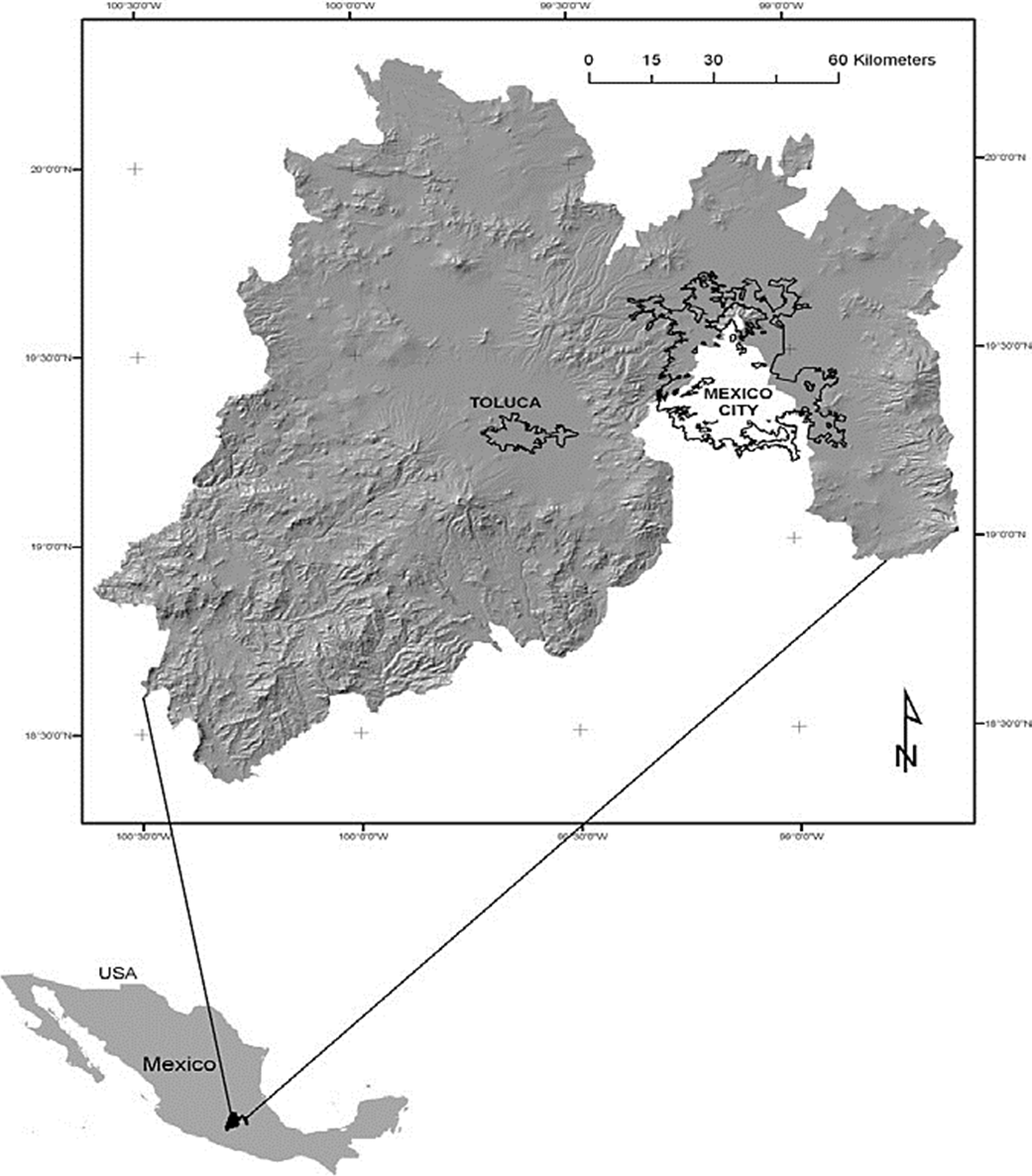
Location of the study area
The State of Mexico is located between 18° 22' 14" and 20° 17' 22" north latitude and between 98° 35' 35" and 100° 36' 19" W (Figure 1). It has an area of 4 303.86 km2. Climates in the state are: mild, semi-cold, warm, semi-warm and cold. The average annual temperature is 6 °C to 28 °C; annual rainfall of 600 to 1 800 mm; while the altitude varies between 340 and 5 100 m (INEGI, 1988; García, 2004b; INEGI, 2006). The dominant soils are andosol, feozem, vertisol, regosol and arenosol (INEGI, 2006, Sotelo et al., 2010).
Methodology
To determine the suitability of the land for maize in the State of Mexico, a multi-criteria analysis using the technique Simple Miltiattribute Rating Technique (SMART) was implemented; (Edwards and Barron 1994; Stewart and Joubert, 2007; Goodwin and Wright, 2014). Which essential part it was to determine the importance (weight) of each variable and standardize its values considering their significance in terms of suitability of the land for maize.
Thus, the relative weight of each criterion was defined by assigning values 0-100 from lowest to highest importance, respectively. Since each test has its own scale and measurement units was necessary to standardize unbiased inclusion in the analysis. In standardization, the values of each criterion is transformed fitness values. All variables or criteria used were considered a discrete scale (classes), so that a direct qualification is used to assign a fitness value to each resulting class (Goodwin and Wright, 2014).
The climate variables were considered for temperature and precipitation; floor: soil type, stage, texture and depth; and physiography: height and slope. For each variable were generated, digital layers with a spatial resolution of 100 m were integrated and analyzed geographic information using Idrisi and ArcGIS (Eastman, 2001; ESRI, 2010).
Weather information obtained from the weather stations spread across the state and adjoining neighboring states. stations with ten years of records are included and counted on rainfall data, evaporation, maximum temperature, minimum and average (Garcia, 2004b). These variables were interpolated with ArcGIS to generate monthly maps.
The soil data were digitized with Arc/Info 6.0 (ESRI, 1992), 1:50 000 letters from the National Institute of Statistics, Geography and Informatics (INEGI) covering the State of Mexico (INEGI, 1988). The database included information generated: units of soils, physical phases, texture, chemical phases, deep soils and shallow soils (IUSS Working Group WRB, 2006; ESRI, 2010; Sotelo et al., 2010). The digital elevation model was downloaded directly from the page INEGI (INEGI, 2012), which layer percent slope terrain using ArcGIS 9.3 (ESRI, 2010) was derived. The requirements for maize were obtained from the website of the FAO and were adapted to the conditions of the State of Mexico (FAO, 2013).
Modeling for maize under the multicriteria approach
Once the weights are defined and digital layers for each variable were generated, it was determined for each pixel fitness field for maize by a weighted linear combination (Malczewski, 1999):
Where: p= suitability of the land for growing maize; wi= weight of criterion i; xi= i standardized criteria for each pixel value.
The values obtained aptitude of the land for maize were sorted into five categories: very good, good, medium, low and unfit. At the end of the shaping bodies of water and added urban areas, as these are important but not conducive agriculture.
Results and discussion
The variables used and their respective rating are shown in Table 1, wherein the variables are temperature greater weight, height and precipitation.
Table 1 Requirements and agro-ecological characterization of the variables for rainfed maize for the State of Mexico.
| Variable | Requerimiento | Calificación | Peso normalizado |
| Temperatura | 10-40 °C | 100 | 24 |
| Altura | 1-2 900 msnm | 90 | 22 |
| Precipitación | 400-1 600 mm | 85 | 20 |
| Tipos de suelos | Profundos y delgados | 80 | 19 |
| Fase de suelos | Físicas y químicas | 30 | 8 |
| Textura | 1-12 | 20 | 5 |
| Pendiente | 0-45% | 10 | 2 |
Weights and ranges of each variable and its classification are presented in Table 2.
Table 2 Variables, intervals and their qualification in defining the potential of rainfed maize in the State of Mexico.
| Variable | Categorías | Intervalo | Valor |
| Temperatura (°C) | Muy bueno | 15-22 | 100 |
| Bueno | 22-28 | 85 | |
| Mediano | 28-32 y 12-15 | 70 | |
| Bajo | 10-12 y 32-40 | 20 | |
| No apto | < 10 y > 40 | 10 | |
| Altura (msnm) | Muy bueno | 1 200- 2 200 | 100 |
| Bueno | 2 200- 2 700 | 95 | |
| Mediano | 0-1 200 | 75 | |
| Bajo | 2 700- 2 900 | 20 | |
| No apto | > 2 900 | 10 | |
| Precipitación (mm) | Muy bueno | 600- 800 | 100 |
| Bueno | 800- 1 200 | 95 | |
| Mediano | 500- 600 y 1 200- 1 400 | 75 | |
| Bajo | 400-500 y 1 400- 1 600 | 20 | |
| No apto | < 400 y > 1600 | 10 | |
| Tipos de suelos | Muy bueno | Andosol y Feozem | 100 |
| Bueno | Vertisol | 95 | |
| Mediano | Fluvisol | 90 | |
| Planosol | 85 | ||
| Cambisol | 80 | ||
| Histosol | 75 | ||
| Regosol | 70 | ||
| Bajo | Acrisol | 50 | |
| Luvisol | 45 | ||
| Leptosol | 20 | ||
| No apto | Solonchak y Gleysol | 10 | |
| Fases físicas y químicas | Muy Bueno | Sin fases | 100 |
| Bueno | Dúrica profunda | 95 | |
| Mediano | Lítica profunda | 90 | |
| Petrocálcica y dúrica | 80 | ||
| Bajo | Gravosa | 40 | |
| Pedregosa y lítica | 30 | ||
| No apto | Salina y sódica | 10 | |
| Texturas | Muy bueno | Media | 100 |
| Bueno | Fina | 95 | |
| Media | Gruesa | 75 | |
| Pendiente (%) | Muy bueno | 0-8 | 100 |
| Bueno | 8-15 | 95 | |
| Mediano | 15-30 | 80 | |
| Bajo | 30-40 | 20 | |
| No apto | >45 | 10 |
Potential areas for maize
The resulting surface for each of the categories of fitness after modeling for the State of Mexico was very good 471 902 ha, good 244 718; 497 404 Medium, Low 556 638; and unfit 430 396 ha, the remaining area of 211 081 and 18 246 ha are urban areas and water bodies respectively (Figure 2).
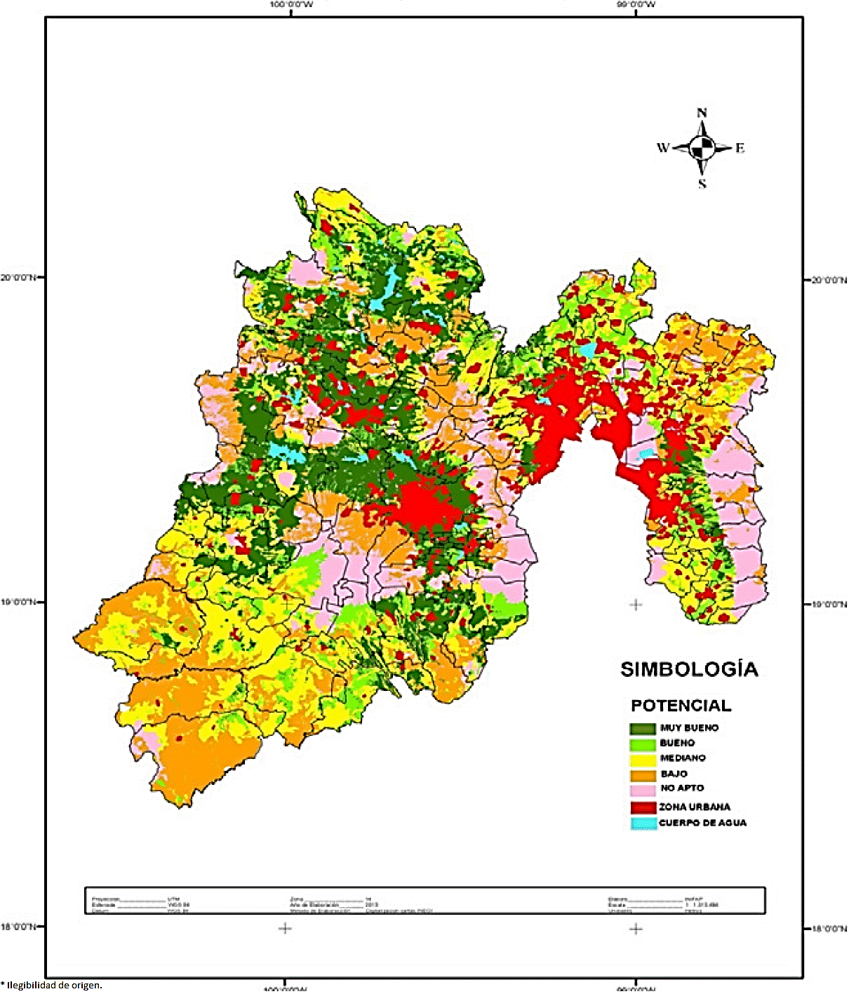
For the State of Mexico, the SIAP (2013) reports 542 528 ha planted maize, so we can say that there is a great difference to the resulting surface potential in this investigation; only for the categories of very good and good are 471 902 and 244 718 ha respectively, so these two categories exceed the area planted in 174 000 ha; moreover the middle has 497 404 ha is an area that has good yields. With these three categories, the resulting potential in this research area is 1 214 024 ha, which doubles the area planted to maize for the State of Mexico. Based to the results the state has surface potential for maize, it only needs to be taken into account studies like this for the implementation and selection of the best areas for planting; therefore, the area and yields will be higher, which will help supply this valuable grain for consumption in the domestic market and the state.
Similar studies with this research, to identify potential areas for development and production of crops are those of Osorio et al. (2012) who mentioned that there is a continuing demand to identify new areas for maize production in Mexico and the world, so that each year the research to generate new methodologies for the identification of areas with potential for this crop is driven. Löffler et al. (2005) mention that the efficiency of a system of land evaluation depends on the detail of information of climate, soil and crop genetics study. Hack-ten et al. (1993) state that in evaluating land productivity and environmental effects must be investigated with information on soil types and land uses.
For his part, Van Diepen (1993) proposed two methodological options for evaluating the potential for grain yield in major crops in the European Community, which are compared with the method of the agro-ecological zones. Shahbazi and Jafarzadeh (2010) use the automated land evaluation of FAO (MicroLEIS) for agro-ecological assessments who conclude that it is an exceptional tool to make recommendations for agriculture and the environment.
Among the studies to identify the adaptability of maize, they are those of Ruiz et al. (2008) who determined the range of climate adaptation and altitudinal 42 races of maize in Mexico; the intervals found for height ranges from 0 to 2 900 m, annual average temperature of 11.3 to 26.6 °C, rainfall of 426-4 225 mm per year and 12.46 to 12.98 hours light. In addition, María (2008) performed an assessment of the production units and concludes that maize should be taken into account socioeconomic characteristics, climate and soil for this type of study.
Gutierrez et al. (2003) used a numerical rating to narrow the adaptation of different varieties and hybrids of maize, which produces groups with clear characteristics in terms of numerical variables; They found a probability of 0.966 in its classification. Camas et al. (2010) applied the methodology of automated land evaluation of FAO, which generated a model for planning the establishment of rainfed maize and conclude that the automated system of agro-ecological zoning allows targeted setting of maize. With regard to agro-ecological zoning studies for seasonal maize is that of Ortiz (1986) who determined 17 611 500 has very suitable nationally. Applying the same methodology Márquez (1990) agro-ecological zones delimited for maize in the State of Mexico, where he found 365 297 has very suitable.
In this research, the surface of very good potential obtained is 471 902 ha. As can be seen, differences exist with respect to the surface of good productivity and well suited with respect to this investigation; the surface obtained in this research is increased by 30 722 hectares with respect to the study Sotelo et al. (2012) those with the nearest surface. The results of this research are high and accurate; so they match what mentioned Malczewski (1999) and Malczewski (2006) who mentions that modeling with geographic information and multi-criteria methodology produces very accurate and reliable results, which are a tool for decision making in the planning and crop zoning.
Different methodologies for the identification and delineation of potential areas for maize depend on the available information and detail thereof; modeling of information is facilitated by the use of geographic information systems. Finally, we can say that this methodology is a good alternative to know the areas with the best conditions of soil, climate and topography for the development and production of rainfed maize in the State of Mexico; the results obtained with this methodology, outperform all submitted by other researchers and methodologies.
Conclusions
The multi-criteria analysis methodology assigns numerical values to the variables used and their adaptation intervals, which are laminated to the definition and delimitation of potential areas, which is more accurate.
Multicriteria methodology generated and used in this research to define potential areas for rainfed maize determined an area of 1 214 024 ha for the categories of very good, good and medium, which have high yields and double the planted area for maize the State of Mexico.
The greatest potential area is concentrated in areas with the best weather conditions (temperature and precipitation), soil types and height are variables with more weight in defining areas adaptation of maize to the present methodology.
The variables that have the greatest weight in the adaptation of maize, for the State of Mexico, are temperature, altitude, rainfall and soil type.
Literatura citada
Barros C. 2009. Maíz alimentación y cultura. Ciencias. 92-93:56-59. [ Links ]
Camas, G. R.; Turrent, F. A.; López, M. J.; Cadena, I. P.; Villar, S. B.; Reynol, M. G. R.; Cruz, C. F. y Cortes, F. J. I. 2010. Evaluación automatizada de tierras para el cultivo de ajonjolí en relevo a Maíz. Rev. Mex. Cienc. Agríc. 1(2):119-131. [ Links ]
Cruz, B. G. M. and Sotelo, R. E. D. 2013. Coupling spatial multiattribute analysis and optimization to identify reforestation priority areas. Mountain Res. Develop. 33(1):29-39. [ Links ]
Eastman, R. R. 2001. Idrisi. Versión I32.2. Manual del usuario. Clark Labs, The Idrisi Project. Clark University. EUA. 960 p. [ Links ]
Edwards, W. and Barron, F. H. 1994. SMART and SMARTER: Improved simple methods for multiattribute utility measurement. Organizational Behavior and Human Decision Processes. 60:306-325. [ Links ]
Espelta, J. M.; Retana, J. and Habrouk, A. 2003. An economic and ecological multi-criteria evaluation of reforestation methods to recover burned Pinus nigra forests in NE Spain. Forest Ecology and Management. 180:185-198. [ Links ]
ESRI. 1992. Arcinfo. Manual del usuario. New York, USA. 359 p. [ Links ]
ESRI. 2010. ArcGis 9.3. Manual del usuario. New York, USA. 985 p. [ Links ]
FAO. 1978. Agroecological zones project Vol. I. Metodology and results for Africa. Rome, Italy. 251 p. [ Links ]
FAO. 1981. Informe de proyecto de zonas agroecológicas. Vol. 3 Metodología y Resultados para América del Sur y Central. Boletín 48. Roma, Italia. 253 p. [ Links ]
FAO. 1985. Directivas: evaluación de tierras para la agricultura de secano. Boletín de suelos Núm. 52. Roma, Italia. 228 p. [ Links ]
FAO. 1997. Zonificación agro-ecológica. Guía general. Boletín de suelos Núm. 73. Roma, Italia. 83 p. [ Links ]
FAO. 2011. El estado mundial de la agricultura y la alimentación. Roma Italia. 197 p. [ Links ]
FAO. 2013. Ecocrop. Rome, Italy. (http://ecocrop.fao.org/ecocrop/srv/en/home). [ Links ]
García, L. 2004a. Aplicación del análisis multicriterio en la evaluación de impactos ambientales. Universidad Politécnica de Cataluña Programa de Doctorado de Ingeniería Ambiental. Barcelona, España. 68-78 pp. [ Links ]
García, E. 2004b. Modificaciones al sistema climático de Köppen para la República Mexicana. Instituto de Geografía. UNAM. Serie de libros Núm. 6. 5a (Ed.). México, D. F. 292 p. [ Links ]
Geneletti, D. 2004. A GIS-based decision support system to identify nature conservation priorities in an alpine valley. Land Use Policy. 21:149-160. [ Links ]
Geneletti, D. 2007. Expert panel-based assessment of forest landscapes for land use planning. Mountain Res. Develop. 27:220-223. [ Links ]
Gkaraveli, A.; Good, J. E. G. and Williams, J. H. 2004. Determining priority areas for native woodland expansion and restoration in Snowdonia National Park, Wales. Biological Conservation. 115(3):395-402. [ Links ]
Goodwin, P. and Wright, G. 2014. Decision analysis for management judgment. 5th (Ed.). John Wiley & Sons, Chichester. New York, USA. 454 p. [ Links ]
Gutiérrez, L.; Franco, J.; Crossa, J. and Abadie, T. 2003. Comparing a preliminary racial classification with a numerical classification of the Maize Landraces of Uruguay. Crop Sci. 43:718-727. [ Links ]
Hack-ten, B. D. J. M.; Van Lanen J. A. H. and Bouma, J. 1993. The leaching potential as a land quality of two Dutch soils under current and potential management conditions. Geoderma. 60(1-4):73-88. [ Links ]
IIASA/FAO. 2012. Global agro‐ecological zones (GAEZ v3.0). IIASA and FAO. Rome, Italy. 360 p. [ Links ]
INIFAP. 1995. Determinación del potencial productivo de especies vegetales en el Estado de México. Zinacantepec, Estado de México. 37 p. [ Links ]
INEGI. 1988. Atlas Nacional del medio físico. Primera reimpresión. Secretaría de Programación y Presupuesto. México, D. F. 543 p. [ Links ]
INEGI. 2006. Estadísticas básicas del Estado de México. Síntesis Geográfica del Estado de México. http://www.inegi.gob.mx. [ Links ]
INEGI. 2012. Sistema de descarga del continuo de elevaciones mexicano http://www.inegi.gob.mx/inegi/default.aspx. [ Links ]
IUSS Working Group WRB. 2006. World reference base for soil resources. A framework for international classification, correlation and communication. 2nd (Ed.). World Soil Resources Reports No. 103. Rome, Italy. 117 p. [ Links ]
Jankowski, P. 1995. Integrating geographical information systems and multiple criteria decision making methods. International Journal of Geographical Information Systems. 9(3):251-273. [ Links ]
Jordan, R. N. 2008. Agroecology in action- extending alternative agriculture through social networks. Crop Sci. 48(4):1642-1643. [ Links ]
Kangas, J. and Kangas, A. 2005. Multiple criteria decision support in forest management- the approach, methods applied, and experiences gained. Forest Ecology and Management . 207:133-143. [ Links ]
Kiker, G. A.; Bridges, T. S.; Varghese, A.; Seager, T. P. and Linkov, I. 2005. Application of multicriteria decision analysis in environmental decision making. Integrated Environmental Assessment and Management. 1:95-108. [ Links ]
Löffler, M. C.; Wei J.; Fast T.; Gogerty, J.; Langton, S.; Bergman, M.; Merrill, B. and Cooper, M. 2005. Classification of maize environments using crop simulation and geographic information systems. Crop Sci. 45(5):1708-1716. [ Links ]
Malczewski, J. 1999. GIS and multicriteria decision analysis. John Wiley and Sons. 2th (Ed.). New York, USA. 393 p. [ Links ]
Malczewski, J. 2006. GIS-based multicriteria decision analysis: a survey of the literature. International Journal of Geographical Information Science. Vol. 20(7)703-726. [ Links ]
María, R. A. 2008. El proceso de análisis jerárquico con base en funciones de producción para planear la siembra de maíz de temporal. Tesis de Doctor en Ciencias. Colegio de Posgraduados en Ciencias Agrícolas. Centro de Edafología. Montecillo, Texcoco, Estado de México. 223 p. [ Links ]
Márquez, R. F. 1990. Zonificación agroecológica del maíz (Zea mays) de temporal en el Estado de México. Tesis de Licenciatura. Departamento de Suelos. Universidad Autónoma Chapingo (UACH). Chapingo, Estado de México. 95 p. [ Links ]
Medina, G. G.; Ruiz, A. C.; Martínez, R. P. y Ortiz, M. V. 1997. Metodología para la determinación del potencial productivo de especies vegetales. Agric. Téc. Méx. 23(1):69-89. [ Links ]
Nadal, A. y Wise, T. 2005. Los costos ambientales de la liberalización agrícola: el comercio del maíz entre México y EU, en el marco del NAFTA. http://ase.tufts.edu/gdae/Pubs/rp/wg/NadalyWise.pdf. [ Links ]
Ortiz, S. C. A. 1986. Evaluación de la aptitud de las tierras de México para la producción de maíz, frijol y sorgo bajo condiciones de temporal. Serie Cuadernos de Edafología Número 8. Colegio de Posgraduados. Chapingo, Estado de México. 39 p. [ Links ]
Osorio, G. N.; López, S. H.; Gil, M. A.; Ramírez, V. B.; Gutiérrez, R. N.; Crespo, P. G. y Montero, P. A. 2012. Utilización, oferta y demanda de tecnología para producción de Maíz en el valle de Puebla, México. Agric. Soc. Des. 9(1):55-69. [ Links ]
Paredes, L. O.; Guevara, F. L. y Bello, L. A. P. 2009. La nixtamalización y el valor nutritivo del maíz. Ciencias. 92-93:60-70. [ Links ]
Parra, U. J. G. 1989. Zonificación agroecológica para la producción de caña de azúcar en algunos estados de México. Tesis de Maestría. Centro de Edafología. Colegio de Posgraduados. Montecillo, Estado de México. 176 p. [ Links ]
Partovi, F. and Hopton, W. 1994. The analytic hierarchy process as applied to two types of inventory problems. Production and Inventory Management Journal First Quarter 1994. ProQuest Science Journals. Drexel University. Philadelfia. USA. 35 p. [ Links ]
Perales, R. H. R. 2009. Maíz riqueza de México. Ciencias. 92-93:46-55. [ Links ]
Romero, C. 1993. Teoría de la decisión multicriterio: conceptos, técnicas y aplicaciones. Alianza Editorial S. A., Madrid, España. 196 p. [ Links ]
Romero, J. y Puyana, A. 2004. Evaluación integral de los impactos e instrumentación del capítulo agropecuario del TLCAN. Documento Maestro. México, D. F. 54 p. [ Links ]
Rothley, K. D. 1999. Designing bioreserve networks to satisfy multiple conflicting demands. Ecological Applications. 9:741-750. [ Links ]
Ruiz, C. J. A.; Durán, P. N.; Sánchez, G. J. J.; Ron, P. J.; González, E. D. R.; Holland, J. B. and Medina, G. G. 2008. Climatic adaptation and ecological descriptors of 42 mexican Maize races. Crop Sci. 48(4):1502-1512. [ Links ]
Sánchez, R. 2010. El Análisis multicriterio en la práctica deseamos contribuir a cerrar la brecha entre la teoría y la práctica del análisis multicriterio. http://analisismulticriterio.blogspot.com/. [ Links ]
SIAP. 2013. Producción agrícola pos estados. http://www.siap.gob.mx/cierre-de-la-produccion-agricola-por-estado/. [ Links ]
Shahbazi, F. and Jafarzadeh A. A. 2010. Integrated assessment of rural lands for sustainable development using MicroLEIS DSS in West Azerbaijan, Iran. Geoderma. 157(3-4):175-184. [ Links ]
Sotelo, R. E. D.; González, A. H.; Cruz, G. B.; Moreno, F. S. S. y Ochoa, E. 2010. La clasificación FAO-WRB y los suelos del Estado de México. Libro técnico Núm. 14. INIFAP. Zinacantepec, Estado de México. 159 p. [ Links ]
Sotelo, R. E. D.; González, A. H.; Cruz, G. B.; Martínez, A. A. M. y Flores, R. L. 2012. Determinación del potencial productivo en cultivos prioritarios en el Estado de México. Libro técnico Núm. 51. INIFAP. Zinacantepec, Estado de México. 258 p. [ Links ]
Stewart, T. J. and Joubert, A. 2007. Conflicts between conservation goals and land use for exotic plantations in South Africa. In: multicriteria analysis for land-use management. Beinat, E. and Nijkamp, P. (eds). Kluwer Academic. Dordrecht, Países Bajos. 36-62 pp. [ Links ]
Stuart, D. and Emerson, B. 2009. Agricultural systems: agroecology and rural innovation for development. J. Environ. Qual. 38:373-374. [ Links ]
Trueba, C. A. 2012. Semillas mexicanas mejoradas de maíz: Su potencial productivo. Colegio de Posgraduados. Montecillo, Estado de México. 132 p. [ Links ]
Turrent, F. A. 1986. Estimación del potencial productivo actual de maíz y frijol en la República Mexicana. Colegio de Postgraduados. Chapingo, Estado de México. 165 p. [ Links ]
Turrent, F. A.; Leyva, R. S.; Espinoza, A. C.; Garza, R. G.; Moreno, R. D. y Aveldaño, R. S. 1992. Manual de diagnóstico recomendación para el cultivo de maíz en el Estado de México. Provincias agronómicas de riego, de muy buena y de buena productividad. Secretaria de Agricultura y Recursos Hidráulicos. Instituto Nacional de Investigaciones Forestales y Agropecuarias. Centro de Investigaciones Región Centro. Campo Experimental Valle de México. Chapingo, Estado de México. 257 p. [ Links ]
Turrent, F. A. 2009. El potencial productivo del maíz. Ciencias. 92-93:126-129. [ Links ]
Valente, R. O. A. and Vettorazzi, C. A. 2008. Definition of priority areas for forest conservation through the ordered weighted averaging method. Forest Ecology and Management . 256:1408-1417. [ Links ]
Valerie, B. and Steward, J. T. 2002. Multiple criteria decision analysis: an integrated approach. Kluwer Academic Publisher. United Kingdom. 125 p. [ Links ]
Van-Diepen, C. A. 1993. Two alternative methods for evaluating regional crop yield potential in the European Community. Geoderma . 60(1-4):359-376. [ Links ]
UCCS. 2009. Ciencia y compromiso social. Ciencias. 92-93:142-145. [ Links ]
Received: September 2015; Accepted: March 2016
 Este es un artículo publicado en acceso abierto bajo una licencia Creative Commons
