


Serviços Personalizados
Journal
Artigo
 texto em
  Inglês (pdf)
 Artigo em XML
 Referências do artigo
 Enviar este artigo por email
Indicadores
-
 Citado por SciELO
 -
 Acessos
Links relacionados
-
 Similares em
SciELO
Similares em
SciELO
Compartilhar

 Permalink
Revista mexicana de ciencias agrícolas
versão impressa ISSN 2007-0934
Rev. Mex. Cienc. Agríc vol.5 no.spe10 Texcoco Nov./Dez. 2014
Articles
Reconstructed volumes in dams of the Valle del Yaqui with annual rings of conifers
1Centro Nacional de Investigación Disciplinaria en Relación a Agua, Suelo, Planta y Atmósfera CENID-RASPA, INIFAP. Margen Derecha Canal de Sacramento km 6.5, Gómez Palacio, Durango, C. P. 35140, México. Tel: 871 159 0104, 159 0105, 159 0107. (villanueva.jose@inifap.gob.mx).
2 Postgrado Forestal, Colegio de Postgraduados, Carr. Mexico-Texcoco km 36.5, Montecillo-Chapingo, Estado de México, C. P. 56230, México. (agomezg@colpos.mx).
3Tree-Ring Laboratory, University of Arkansas, Fayetteville, Arkansas. (dstahle@uark.edu).
4 INIFAP Campo Experimental "Altos de Jalisco", Tepatitlán, Jalisco. (ruiz.ariel@inifap.gob.mx).
A dendrochronological network ofearly and late-wood and full ring of Pseudotusga menziesii was developed for the upper basin oftheYaqui river (CRY) to explain the historical runoffvolumes recorded in the basin and sub-basins feeding three of the largest dams (Angostura, Novillo, Oviachic) in the State of Sonora, which supply water annually for about 250 000 ha. The chronologies showed an inter-annual and multi-annual climate variability (r >0.60, p< 0.01), suggesting the influence of common weather phenomena; situation that allowed them within a regional chronology of 479 years (1534-2012) in length. The regional chronology of earlywood responded to the accumulated rainfall from February to May and runoff volumes from October to June, representing 43% of the annually registered in the CRY. Both variables were correlated (r= 0.83, p< 0.01, n= 479), suggesting that the annual runoff has high influence of the winter-spring precipitation. At sub-basin level, the dendrochronological series showed a significant association with the volumes recorded in the respective dams, but the limited number ofseries prevented a more complete analysis ofthe hydroclimatic variability, so it is important to expand it. ENSO was the phenomenon that affected the most the variability in rainfall and runoff ofthe winter-spring period.
The association between regional chronology ofearly-wood and the Southern Oscillation Index (SOI) was negative, but significant in the winter (r= -0.59, p< 0.01), implying high influence of the warm phase of this phenomenon in the natural climate variability.
Keywords: Pseudotsuga menziesii; dendrochronology; ENSO; runoff
Una red dendrocronológica de maderatemprana, tardía y anillo total de Pseudotusga menziesii se desarrolló para la cuenca alta del Río Yaqui (CRY), para explicar los volúmenes históricos de escurrimiento registrados en la cuenca y subcuencas que alimentan tres de las más grandes presas (Angostura, Novillo, Oviachic) en el estado de Sonora, que irrigan anualmente cerca de 250 000 ha. Las cronologías mostraron una variabilidad climática interanual y multianual similar (r> 0.60, p< 0.01), lo que sugiere la influencia de fenómenos climáticos comunes; situación que permitió integrarlas en una cronología regional de 479 años (1534-2012) de extensión. La cronología regional de madera temprana respondió a la precipitación acumulada febrero-mayo y a los volúmenes de escurrimiento octubre-junio, que representan 43% de los registrados anualmente en la CRY. Ambas variables estuvieron correlacionadas (r= 0.83, p< 0.01, n= 479), sugiriendo que el escurrimiento anual tiene alta influencia de la precipitación invierno-primavera.A nivel subcuenca, las series dendrocronológicas mostraron una asociación significativa con los volúmenes registrados en las presas respectivas, pero el número limitado de series previno un análisis más completo de la variabilidad hidroclimática, por lo que es importante su expansión. ENSO fue el fenómeno climático que más impactó la variabilidad en la precipitación y escurrimientos del período invierno-primavera. La asociación entre la cronología regional de madera temprana y los índices de Oscilación del Sur (SOI) fue negativa, pero significativa en la época invernal (r= -0.59, p< 0.01), lo que implica alta influencia de la fase cálida de este fenómeno en la variabilidad climática interanual.
Palabras clave: Pseudotsuga menziesii; dendrocronología; ENSO; escurrimientos
Introduction
The increase on the demand for water resources in northwestern Mexico, requires a more detailed knowledge of the climatic variations ofhigh and low frequencies that occur directly at the sites of water uptake, such as the Sierra Madre Occidental (SMO), where the runoffs are generated, draining into the major reservoirs located in the lower part oftheYaqui river Basin (CRY), subsequently used for surface irrigation. Knowing in detail the hydroclimatic fluctuations and trends, will allow to substantiate actions of integral management of water considering this behaviour and allow planning the release of the volumes of water, according to this variability.
The aim ofthis study was to develop a dendrochronological network of earlywood, latewood and full ring specimens of Douglas-fir (Pseudotsuga menziesii Mirb. Franco) in the upper CRY and relate it with climate and runoff data recorded in the basin and with the water volumes generated at sub-basin level and captured in the different dams; this information is of scientific relevance to model trends of hydroclimatic variability in this basin and justify actions for the conservation of water production sites for planning a sustainable management of water resources based on the frequency of extreme events.
Description of the study area
The Yaqui river basin is located in the southern State of Sonora at the geographical coordinates 27° 00' to 27° 40' north latitude and 109° 40' to 110° 25' west longitude. Geologically composed of sedimentary rock, intrusive and extrusive igneous, metamorphic and volcano-sedimentary; with a diversity of climates dominated by dry, semi-dry and humid. The average annual precipitation is 518 mm, which is presented in its highest proportion in summer (July to September); while the average annual temperature is 19 °C (CONAGUA, 2008).
The CRY covers an estimated area of 72 000-79 172 km2 of which; 74% is located in Sonora, 21% in Chihuahua and 5% in Arizona, USA. The tributaries of the Yaqui river are the Bavispe and Moctezuma-Nacozari rivers in Sonora; Papigochic, Sirupa and Aros in Chihuahua, Leslie and Whitewater in the USA (Lutz and Curl, 2014). In the Yaqui river there are three of the largest dams in northwestern Mexico, called "La Angostura" (Lázaro Cárdenas), built in 1941 and located in the river Bavispe, "El Novillo" (Plutarco Elías Calles) located in the confluence of the rivers Yaqui and Moctezuma, built in 1965 and "The Oviachi" (Alvaro Obregón) located in the lower part of the basin, near Cd. Obregón, Sonora built in 1952. The surface of the sub-basins fed these dams is 19 292, 40 368 and 11 792 km2, with a storage capacity of 921, 3 020 and 3 227 (10 6 m 3), respectively (CONAGUA, 2008).
The mean annual discharge ofthe basin is estimated at about 3 000 * 106 m3, which feeds two large irrigation districts known as "Valle del Yaqui" and "Colonia Yaquis" where a population is settled in both sides of the border is over 1.2 million people. 82% of the runoffs, occur in the upper part ofthe Yaqui basin in the province ofhydrogeological SMO; particularly in ecosystems with the presence ofmixed forest vegetation, volumes that are conducted through tributaries that originate in the States ofSonora and Chihuahua (Vega-Granillo et al, 2011).
Materials and methods
Cores growth and cross sections ofselected individuals from Douglas-fir (Pseudotsuga menziesii) and Pinus arizonica were collected in mixed conifer forests in the southeastern section ofthe CRY in the State of Chihuahua. The collection sites were distributed in the eastern sub-basin El Novillo in the State of Chihuahua, these were "Tutuaca" within the conservation area Cebadillas-Tutuaca, Cebadillas de Ocampo, Bisaloachi, "Madera" in communal land "El Largo y Anexos", "Bocoyna" and "Basagochi" only the place "Bacadehuachi"was at the north end of the CRY in the State of Sonora.
At each site, ancient trees were selected and radial increments were obtained with a Pressler drill. In addition, cross sections of dead trees were collected to facilitate and achieve extending dendrochronological date time series. The samples were dated by conventional dendrochronological techniques (Stokes and Smiley, 1968; Fritts, 1976). Each individual growth was divided into bands of earlywood, latewood and full ring growth (EW, LW and RW) measured with a conventional measurement system VELMEX. The co-dated and accuracy of measurement of each ring was verified with the program COFECHA(Holmes, 1983). Biological trends unrelated to climate were removed using the ARSTAN program (Cook, 1987), through the standardization process. Generating a ring width index (RWI), another of earlywood (EWI) and latewood (LWI).
The association between dendrochronological series developed both within the CRY, and outside of it was analysed by simple and main components correlations to determine those with a common climate response and integrate a representative chronology of the basin for comparison with climatic variables and hydrometric.
Timelines also compared with runoff volumes recorded in each of the dams and the total runoff recorded by runoff from rivers that discharge into the CRY. Considering the abnormality of the hydrometric data, these were normalized to transform them into logarithmic, quadratic, square root and reciprocal values, then compared against the dendrochronologic indices to determine the best association in explaining fluctuation of high and low frequency, characterize by the availability of water resources in this area.
Annual rates of individual dendrochronological series and regional representative of the CRY, compared with ENSO indices to define the impact of this circulation pattern, which explains much of the winter-spring hydroclimatic variability observed at the regional level (Díaz et al., 2002; Cleaveland et al., 2003; Nicholas and Battisti, 2008; Villanueva et al., 2009; Cerano et al., 2012). The association with these circulatory phenomena was conducted to compare both the individual and the regional dendrochronological indices registered with the Southern Oscillation (SOI) indices (Allan et al, 1996), reconstructed SOI indices for northern Mexico (Stahle et al., 1998), and tropical rain index (TRI), which is an estimate of the variability of ENSO (Wright, 1970).
The dendroclimatic reconstructions developed were verified as far as possible with previous reconstructions and historical documents related to the production of food and other social and economic impacts described for the region (McCullough, 2005; Endfield and Fernández, 2006).
Results
Dendrochronological network
The dendrochronological network was confirmed by seven sampling sites of Douglas-fir, in water capture in part of the CRY in the State of Chihuahua. Two additional chronologies ofDouglas-fir (Sierra de losAjos) and a Pinus arizonica (Bacadehuachi) for the northern part ofthe CVY in Sonora and three additional chronologies in the southern part of Chihuahua (Table 1).
Table 1 Collecting sites, geographic coordinates and extent of chronologies generated in CRY in the States of Chihuahua, Sonora and outside the basin for comparison.

Six of the chronologies (TUT, BIS, CDO, MAD, CAC, ENA) were located in the central portion of the sub-basin that drains into the dam "El Novillo" and one more (MDG) at the north end of the same sub-basin (Figure 1). When considering as reference the dendrochronological series offull ring of Tutuaca, it was determined that there is a correlation exceeding 0.60 (p< 0.001) formost ofthe series located within the same watershed.

Climatic response of the chronologies
The chronology of Tutuaca and the regional integrated by CDO, MAD, MDG, TUT, BIS, CAC and ENA sites within the sub-basin of El Novillo, was compared against the average rainfall data from weather stations on this sub-basin such as "Peñitas" stations (29,217° north latitude, 108.023; 2 212 m), "Tres Ojitos" (or 28.917° North latitude, 108.083° west longitude, 2 600 m), "Madera" (29.20° North latitude, 108.10° west longitude, 2092 m) and "La Junta" (28.75° north latitude, 107.96° west longitude, 2053 m). The standard chronology EW of the Tutuaca site, as well as the regional showed a significant correlation with cumulative rainfall from February to May with values of 0.73 and 0.74 (from 1938 to 1988, p< 0.01), respectively. For purposes of reconstructing the variability of rainfall, the regional chronology was used, which integrates climate variability in this area and is more representative of the dominant hydroclimatic conditions of the sub-basin.
Available precipitation records (1938-1988) were divided into two sub-periods for calibration (1938-1964) and verification (1965-1988). Because both sub-periods with significant correlations were 0.83 and 0.71, respectively, the total period of data (1938-1988) was used to generate a linear model reconstruction, which is as follows:

Where: Ppt= is the reconstructed seasonal rainfall from February to May (mm); Xi= annual rate of earlywood.
The seasonal reconstruction from February to May (winter-spring) showed high inter-annual variation in 479 years (1534 to 2012) of extension ofthe reconstruction (Figure 2). Extremely dry periods occurred in 1541-1552, 1608-1624, 1666-1676, 1681-1695, 1733-1743, 1770-1779,1801-1806 (except 1804), 1840-1843, 1860-1866, 1879-1887 , 1892 1894,1908-1911, 1934-1939,1949-1956,1959-1963,1993 1996 and 2002-2012 (except 2010). Wet periods were less frequent and ofshorter duration and some ofthe most intense occurred in 1569-1603, 1649-1655, 1744-1747, 1780-1784, 1872-1878, 1923-1926 and 1983-1987.

Figure 2 Seasonal reconstruction of the precipitation winter-spring (February-May) for the producing sub-basin of water of the SMO in the State of Chihuahua and drainage towards CRY.
The standard regional chronology EW showed a significant association (r= 0.55, 1902-2003, n= 102, p< 0.001) with the reconstructed winter-spring precipitation (November-April) for CRY. Regarding the regional chronology LW, it did not indicate any association with summer precipitation index for the total area ofthe CRY; values generated by integrating the database of Hulme et al. (1998) for the period 1900-1996 and Lettermaier and Zhu (2007) from 1925 to 2004 (Nicholas and Battisti, 2008).
In the case of El Novillo dam, the highest correlation (r= 0.41, 1964-2006, n= 43, p< 0.05) occurred by linking the regional chronology west longitude and the monthly cumulative volumes of the tributaries of such sub-basin for the period from January to May. Finally, the annual amount of the tributaries of the dam Oviachi was correlated with the regional chronology RW (r= 0.49, 1952-2006, n= 55, p< 0.01).
The association between the inputs (deducted contributions + rainfall) of the system of dams of the Yaqui river and regional chronology EW, showed a significant association (r= 0.71, 1956-2012, p< 0.01), so this association was used to reconstruct the total volumes of flow entries ofthe dams. Available records were divided into two portions, one for calibration (1984-2012) and another for verification (1957-1983). The correlations for both sub-periods were 0.76 (p< 0.01) and 0.72 (p< 0.01), respectively, due to the significance of the two sub-periods, the total period (1957-2012) of available data was used to generate the model reconstruction, which was as follows:

By applying the linear model of indexes EW, we generated a reconstruction of the volumes in logarithms base 10, values transformed by the antilog into seasonal volumes (Figure 3). The reconstruction showed high variability over time in the presence of dry and wet periods even more intense than those detected in the hydrometric instrumental records; indicative situation of the probability that events of that scale might be presented again.

Figura 3 Entradas acumuladas octubre-junio de los volúmenes reconstruidos de los últimos 479 años (1532-2012), de los principales ríos que alimentan la CRY.
The relationship between the reconstruction of drained volumes (October to June) in the CRY and the winter-spring precipitation (February-May) in the upper basin in the State of Chihuahua, indicated a correlation of 0.83 (p < 0.001) indicative of the great importance of hydrological basins in the SMO to explain the variability in water availability in the "Valle del Yaqui", highly significant value for the last 479 years. As with precipitation, periods of availability of below-average volumes were more frequent than those with higher runoff (Figure 4).

Figure 4 Years with entries accumulated in the CRY in the period from October to June below the average. (Black bars) and those with runoff above the mean (bars). Dominance of below average runoff is observed.
The reconstructed volumes are characterized by the dominance of dry periods of 2 to 5 years (52 events), although, the periods were also presented to more than 10 consecutive years (4 events), as occurred in 1541-1552, 1610-1620, 1771-1782 and 1998-2008. Wet periods were less common and dominated the two (24 events) and three consecutive years (3 events) and only the intervals 1638 1643, 1580-1587 and 1809-1818, exceeded six years with above-average runoff.
Association between the southern oscillation index and regional dendrochronological series
One of the phenomena ofgreatest impact in the hydroclimatic variability in northern Mexico is ENSO, particularly during the warm phase, characterized by an increase in winter precipitation (Stahle et al., 1998). Comparing the rates of regional EW chronology and indices SOI, as well as those generated by Allan et al. (1996) , National Climatic Data Center (NOAA, 2014), TRI (Wright, 1970) and the reconstructed for northern Mexico (Stahle et al, 1998), a significant association between the two variables was found (Table 2).
Table 2 Relationship between the regional chronology EW for the CRY and average seasonal indices SOI of the winter-spring period.

The relationship found between the SOI indices reconstructed for northern Mexico and the regional EW series corroborate the favourable effect of this phenomenon by increasing the precipitation of the winter period in this region. However, this influence was not stable and showed fluctuations over time (Figure 5). Thus, in sub-periods of 25 years, the correlations were minimal from 1756 to 1780 (r= 0.01), although in other sub-periods exceeded a correlation of0.70. These results indicated that in this region, the annual growth ofearlywood explains up to 35% ofthe variability of ENSO.
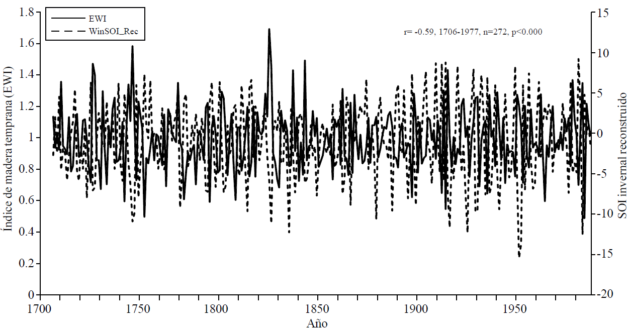
Figure 5 Relationship between the regional chronology EW of the CRY and the reconstructed SOI index for northern Mexico.
The NorthAmerican Monsoon phenomenon has a significant influence in this region, particularly in the summer, where over 50% of the runoff occur at the dams (Douglas et al, 1993), notwithstanding the foregoing, the inter-annual and multi-annual variability is comparatively low relative to the historical average. In this study, we did not find any significant relationship between the index EW, LW or RW with the regional precipitation in summer reconstructed by Nicholas and Battisti (2008) for the CRY; result reflected in the poor potential of Douglas rings.
Discussion
The dendrochronological series generated in the eastern portion of the CRY in the State of Chihuahua, showed a common annual and multi-annual variability, as inferred from the high correlations between individual chronologies (0.60 to 0.75). This similar behaviour is the impact of common climatic variables that affect the zone in an area of approximately 15 000 km 2, which nevertheless constitute only 21% of the total area of the basin, represents a very important source of water to the availability of runoff in the Valle del Yaqui.
Chronologies of Pseudotsuga menziesii developed in northern Mexico are very sensitive to hydroclimatic variability, as demonstrated with various reconstructions of precipitation for Chihuahua (Díaz et al, 2002; Villanueva et al, 2009) and Durango (Cleaveland et al, 2003; González et al, 2005; Villanueva et al, 2005).
The regional series EW for the upper basin of the Yaqui river was sensitive to the winter-spring precipitation, the reconstruction developed for this sector of the basin is important to quantify the precipitation that occurs at this time of the year, of which depends the growth of earlywood of conifers of commercial interest and at the same time determine the fluctuations in water availability in the winter, with rains, though not of great intensity, it does promote storage in the soil matrix, for being used for the trees at the start of the growing season (Cleaveland et al., 2003; Villanueva et al, 2009).
The major droughts detected in the rebuilding of seasonal rainfall as those occurred in 1541-1552, 1608-1624, 1733-1743, 1770-1779, 1860-1866, 1879-1887, 1934 1939, 1943-1956 and 1993-2012, have been reported in previous reconstructions for Durango and Chihuahua (Díaz et al., 2002; Cleaveland et al., 2003; Villanueva et al., 2009; Sosa-Nájera et al., 2010), and some ofthem like in the 1550s were also recorded for the northeastern and central Mexico (Therrell et al., 2006). The effects ofthese droughts affected the availability of food and some famines and epidemics that decimated the indigenous population remarkably presented, such as the drought of 1540-1550, which severely affected the central and northern Mexico (Acuña-Soto et al., 2002).
In the period 1804-1806 a severe drought in the region of Chihuahua and Durango crisis that produced food production was presented. Periods of severe drought as those occurred in the 1860, 1890, 1900, 1950 and 1990 have been reported in various paleoclimatic reconstructions (Villanueva et al., 2009) and for the recent droughts (1992-2004, 2002-2012) agricultural production data for the CRY indicate an impact, in both cultivated surface as well as in units yields of wheat (CONAGUA, 2008; Cruz and García, 2008).
The observed relationship between the dendrochronological series developed in each of the sub-basins and runoff volumes recorded in dams was significant. In the case of La Angostura Dam, the dendrochronological series EW of the MDG site explains 45% of the runoff therein recorded from October to June, information that confirms its high potential for the development of historical reconstructions of this variable. Individual dendrochronological series like Tutuaca or Bisaloachi were not correlated with runoff volumes recorded in the dams El Novillo or Oviachi, but with the total regional chronology or latewood ring; correlations, however, although significant, did not exceed 0.49 (p< 0.05, 1952-2006), which shows the need to expand the dendrochronological network in each of the sub-basins to rebuild its historic flow and analyse in detail its variability over time.
The ability of the chronologies looking to analyse the variability in the availability of water resources in the CRY, manifested by integrating series of chronologies with a common response; in this aspect, the regional chronology EW conformed of seven chronologies distributed in the sub-basin of El Novillo explained the variability in runoff accumulated from October to June for all the CRY, volumes that constitute 43% of the runoff recorded during the agricultural cycle. This reconstruction suggests that the planning of the agricultural cycle in terms of cultivated area should not be based on average runoff records of the last 70 years; in contrast, we should considered extreme events up to 10 consecutive years presented at least once per century, which have affected the Valle del Yaqui in the last 479 years.
The hydroclimatic variability detected in this region, particularly during the winter period has high influence of ENSO (Stahle et al, 1998; Nicholas and Battisti, 2008). The association found between the reconstructed indices EW and SOI was -0.59, a situation that implies that the warm phase of this phenomenon was a favourable effect by increasing winter precipitation, but also intense droughts during the cold phase, as in the past decade with a drastic reduction in acreage.
Conclusions
The dendrochronological series developed in the CRY and in particular those located in the sub-basin El Novillo have a similar annual and multi-annual variability because they are affected by climatic events, making a common influence on radial growth of Douglas-fir in this region. This behaviour allowed integrating the dendrochronological series in a regional chronology, representative ofthe entire basin and useful to reconstruct and analyse the variability of seasonal rainfall, runoff and define the impact of general circulation patterns, such as ENSO, in over 450 years of the generated series.
Runoff records in the dam La Angostura were significantly related to the dendrochronological series EW of the site MDG; this relationship although significant, could be improved by generating a dendrochronological network at sub-basin level, capturing all the climate variability.
Reconstructions of seasonal precipitation and runoff with the regional series EW were highly correlated, implying that the winter-spring precipitation determines runoff that occur in the period from October to June and constitute 43% ofthose recorded in the CRY. Summer precipitation, which causes 57% of the runoff presented from July to September is influenced by the NorthAmerican Monsoon, which did not showed high inter-annual variability and was not reflected in the growth of latewood; This situation suggests the need to develop a dendrochronological network more complete of latewood series of Douglas-fir and other conifers, in order to define more clearly the potential effect of precipitation on radial increment of tree species.
The variability of inter-annual on the growth of earlywood in the CRY was significantly associated with the SOI, this relationship although high it was not constant over time, but in certain sub-periods exceeded 0.70, which implies the potential to generate predictive models of runoff based on the increasing ratio radial-ENSO. Many of the dry and wet periods detected in the reconstructions have been reported in reconstructions for northern and central Mexico, suggesting that such studies should be promoted to a better understanding of natural hydroclimatic variability and caused by anthropogenic causes.
Literatura citada
Acuña-Soto, R.; Stahle, D. W.; Cleaveland, M. K. and Therrell, M. D. 2002. Megadrought and megadeath in 16th century Mexico. Revista Biomedica 13:289-292. [ Links ]
Allan, R.; Lindesay, J. and Parker, D. 1996. El Niño/Southern Oscillation & climate variability. CSIRO Publishing. Atmospheric Research, Australian National Univesity, United Kingdom. Meteorological Office. 408 p. [ Links ]
Cerano Paredes, J.; Villanueva, D. J.; Valdez, R. D. C.; Constante, G. V.; González, B. J. L. y Estrada, A. J. 2012. Precipitación reconstruida para la parte alta de la cuenca del río Nazas, Durango. Rev. Mex. Cienc. Fores. 2(10):7-23. [ Links ]
Cleaveland, M. K.; Stahle, D. W.; Therrell, M. D.; Villanueva, D. J. and Burns, B. T. 2003. Tree-ring reconstructed precipitation and tropical teleconnections in Durango, Mexico. Climatic Change 59:369-388. [ Links ]
Comisión Estatal del Agua. 2008. Estadísticas del agua en Sonora. México, D. F. 237 p. [ Links ]
Cruz Medina, R. E. y García Páez, F. 2008. Modelación de escurrimiento del río Yaqui. Terra Latinoamericana. 26(2):145-152. [ Links ]
Comisión Nacional delAgua (CONAGUA). 2008. Statistics on water in Mexico. México, D. F. 186 p. [ Links ]
Cook, E.R. 1987. The decomposition oftree-ring series for environmental studies. Tree-Ring Bulletin 47:37-59. [ Links ]
Díaz, S. C.; Therrell, M. D.; Stahle, D. W. and Cleaveland, M. K. 2002. Chihuahua winter-spring precipitation reconstructed from tree-rings. Climate Res. 22(3):237-244. [ Links ]
Douglas M. W.; Maddox R.; Howard, K. and Reyes, S. 1993: the Mexican monsoon. J. Climate 6:665-1667. [ Links ]
Endfield, G. H. and Fernández I. 2006. Decades of drought, years of hunger: archival investigations ofmultiple year droughts in late colonial Chihuahua. Climate Change75:395-419. [ Links ]
Florescano, E. 1980. Una historia olvidada: la sequía en México. Rev. Nexos 32:9-13. [ Links ]
Fritts, H.C. 1976. Tree rings and climate. London Academic Press. New York. 565 p. [ Links ]
González-Elizondo, M.; Jurado, E.; Navar, J.; González-Elizondo, M. S.; Villanueva, J.; Aguirre, O. and Jiménez, J. 2005. Tree-rings and climate relationships for Douglas-fir chronologies from the Sierra Madre Occidental, Mexico: a 1681-2001 rain reconstruction. Forest Ecol. Management. 213:39-53. [ Links ]
Griffin, D.; Meko, D. M.; Touchan, R.; Leavitt, S. W. and Woodhouse, C. A. 2011. Latewood chronology development for summer-moisture reconstruction of the US Southwest. Tree-Ring Res. 67(2):87-101. [ Links ]
Holmes, R. L. 1983. Computer-assisted quality control in tree-ring dating and measurement. Tree-Ring Bulletin. 43:69-78. [ Links ]
Hulme, M. T.; Osborn, J. and Johns, T. C. 1998: Precipitation sensitivity to global warming: comparison ofobservations with HadCM2 simulations. Geophysical Research Letters 25:3379-3382. [ Links ]
Lutz, A. y Curl, K. 2014. Panorama de la Cuenca del Río Yaqui. http://aquasec.org. [ Links ]
McCullough, E. 2005. Coping with drought: an analysis of crisis responses in the Yaqui Valley. Thesis of Master Degree. Department of Earth System Program. Standford University, USA. 71 pp. [ Links ]
Nicholas, R. E. and Battisti, D. S. 2008: Drought recurrence and seasonal rainfall prediction in the Río Yaqui Basin, Mexico. J. Appl. Meteorol. Climatol. 47:991-1005. [ Links ]
NOAA. 2014. SOI-National Climatic Data Center (http://www.ncdc.noaa.gov.teleconnections/enso/indicators/soi.php). [ Links ]
Sosa-Nájera, S.; Lozano-García, S.; Roy, P. D. y Caballero, M. 2010. Registro de sequías históricas en el occidente de México con base en el análisis elemental de sedimentos lacustres: el caso del lago de Santa María del Oro. Boletín de la Sociedad Geológica Mexicana. 62(3):437-451. [ Links ]
Stahle, D.W., R.D. Dárrigo, P.J. Krusic, M.K. Cleaveland, E.R. Cook, R.J. Allan, J.E. Cole, R.B. Dunbar, M.D. Therrell, D.A. Guy. M.D. Moore, M.A. Stokes, B.T. Burns, J. Villanueva-Diaz, and L.G. Thompson. 1998. Experimental dendroclimatic reconstruction of the Southern Oscillation. Bulletin of the American Meteorological Society. 70(10): 2137-2152. [ Links ]
Stahle, D. W.; Burnette, J. D.; Villanueva-Díaz, J.; Heim, Jr. R. R.; Fye, F. K.; Cerano Paredes, J.; Acuna Soto, R. and Cleaveland, M. K. 2011. Pacific and Atlantic influences in Mesoamerican over the past millennium. Climate Dynamics: DOI 10.1007/s00382-011-1205-z. [ Links ]
Stokes, M.A. and Smiley, T. L. 1968.An introduction to tree-ring dating. University of Arizona Press, Tucson, Az., USA. 73 pp. [ Links ]
Therrell, M. D.; Stahle, D. W.; Villanueva-Díaz, J.; Cornejo-Oviedo, E. and Cleaveland, M. K. 2006. Tree-ring reconstructed maize yield in central México: 1474-2001. Climatic Change 74:493-504. [ Links ]
Vega-Granillo, E. L.; Cirett-Galán, S. De la Parra-Velasco, M. L. y Zavala-Juárez, R. 2011. Hidrogeología de Sonora, México. In: Calmus, T. (Ed.). Panorama de la geología de Sonora, México: Universidad Nacional Autónoma de México (UNAM). Instituto de Geología (IG).118(9): 57-88. [ Links ]
Villanueva, D. J.; Luckman, B. H.; Stahle, D. W.; Therrell, M. D.; Cleaveland, M. K.; Cerano-Paredes, J.; Gutiérrez-García, G.; Estrada-Avalos, J. y Jasso-Ibarra, R. 2005. Hydroclimatic variability of the upper Nazas basin: water management implications for the irrigated area of the Comarca Lagunera. Dendrocronología. 22(3):215-223. [ Links ]
Villanueva Diaz, J.; Peter, F. Z.; Cerano, P. J.; Estrada, A. J. y Sánchez, C. I. 2009. Reconstrucción de la precipitación estacional para el barlovento de la Sierra Madre Occidental. Cienc. Fores. Méx. 34(105):37-69. [ Links ]
Woodhouse, C. A.; Stahle, D. W. and Villanueva, D. J. 2012. Rio Grande and Rio Conchos water supply variability over past 500 years. Climate Res. 51:125-136. [ Links ]
Wright, P. B. 1979. Persistance ofrainfall anomalies in the Central Pacific. Nature 277:371-374. [ Links ]
Zhu, C. and Lettenmaier, D. P. 2007: Long-term climate and derived surface hydrology and energy flux data for Mexico, 1925-2004. J. Climate. 20:1936-1946. [ Links ]
Received: May 2014; Accepted: October 2014
 Este es un artículo publicado en acceso abierto bajo una licencia Creative Commons
