


 nova página do texto(beta)
 Inglês (pdf)
 Artigo em XML
 Referências do artigo
 Enviar este artigo por email
 Citado por SciELO
  Similares em
SciELO
Similares em
SciELO 
 Permalink
Introduction
There is a worldwide water crisis growing due to climate change and other significant mega-trends like accelerated urbanization. The megalopolis of the state of Mexico City (CDMX) is at particular risk due to extreme water vulnerability for several overlapping reasons, including geographic difficulties for supplying water to some areas, a population density which exceeds the supply capacity, a lack of sufficient infrastructure necessary for urban water and sewer systems, the combination of scarcity-abundance and water pollution, as well as governance and public policy problems. From our perspective, the complexity of a People and Water system provides a framework to better understand the co-evolutionary trajectories of systems in which people and water are joined (Sivapalan et al., 2012).
In this paper, we analyze socio-hydrological vulnerability (SHV) in terms of “space”, a concept which facilitates the understanding of the physical and social vulnerabilities of a territory and its inhabitants from a dynamic perspective. The concept of space encompasses the network of social relations that provides a point of reference, which in turn promotes the development of multiple identities, strengthens social capital and generates innovative forms of productive investment. Through this lens, researchers and planners can recognize a multiplicity of actors and sites for achieving adaptation and resilience in the face of vulnerabilities. On the other hand, SHV is generally expressed in terms of exposure, sensitivity, and adaptation of a community. It is an indicator that brings together hydrological aspects and their relationships with the values, positions, and knowledge of society (Jaramillo et al., 2018). By including an analysis of the surrounding space into the study of SHV, we provide an understanding of the relationship between SHV and how a space is lived, understood, and changed. Our study focuses water vulnerability in a given context, using it as an example of a more general SHV and space analysis, since water vulnerability is a consideration that is common in the CDMX region.
Research on water issues in CDMX generalizes results without considering the specificities of the various territories (jurisdictional zones that belong to the State) and spaces the city contains (St. George Freeman et al., 2020; Escolero et al., 2016). In this study we show that focusing the analysis into the specific characteristics of a space like the Cuajimalpa de Morelos municipality, referred to from now on as Cuajimalpa, can show different perspectives, potential actions and resources of vulnerability-adaptation-resilience. The objective of this article is to analyze how space is constructed, and to understand and explain the processes of vulnerability-adaptation-resilience within a specific territory confronting its water problems. The key contribution of this work is its interdisciplinary approach, through the use of a mixed methodology, to study Cuajimalpa’s socio-hydrological vulnerability (SHV).
This text has five sections. The first describes the analytical categories and the theoretical framework for studying SHV holistically, including the concept of space. The second explains the case under study, Cuajimalpa. The third refers to the methodology used to evaluate Cuajimalpa’s SHV. The results are highlighted and discussed in the fourth section. The last section provides conclusions and recommendations for future work.
1. Analytical categories
Water is arguably the most important natural resource for the development of human activities. However, Mexico City is experiencing a three-fold problem of scarcity-abundance-pollution that is only increasing over time. The main causes of this phenomenon can be found in the delays in maintenance and replacement of water and sewer networks, the lack of infrastructure to use and re-use rainwater, and the over-exploitation of aquifers. Each of these factors gives rise to inequitable distribution of water in the city, but also to floods in different areas and to contamination of rivers and urban supply sources. To understand the causes and effects of these factors, it is important to study and analyze the space and its social dynamics.
1.1. Space and its Social Dynamics
The analysis proposed here, considers space as a social construct that arises from the processes of production, reproduction, transformation, appropriation, use, management and communications. Classical authors formulate key questions related to the social construction of space and established the axes of the relationships between existing spaces and their social transformations in a context of dependency.
Considering the cultural dimension of “significant places” and the spaces of everyday life, Lefebvre (1991) maintains that culture and meaning, or significance, are intimately connected to the economic and political dimensions of the social production of a space. For Lefebvre, to inhabit is to produce habitat, appropriate the territory and reinvent it with a unique symbolic charge (De Reymaeker, 2012). Resulting from this analysis, space, then, is the material outcome of productive processes and courses of social appropriation.
Bourdieu (1999), identifies social space as the materialization of power relations and the interactions among agents within fields of force, where subjects deploy their capital to structure differences with a dialectic of conflict and in a continuous projection of their social representations. The dispositions of the habitus are precisely those mechanisms of possession and position over/in space that produce territory. It is here that the actors both display their differences, in a dialectic of conflict and projection of their social representations and at the same time, they appropriate, inhabit, and give significance to the space.
From this perspective, space is not merely a passive reflection of society; space plays an active role in producing and reproducing society (Warf and Arias, 2008). The concept of space into the study of social phenomena implies a transformation of economics, politics and culture. There is a dialectic relationship between the actors and the space as they reconfigure each other. Space is important, not only as an element of context, but also as a factor that transforms subjectivities and imaginaries in the ways of thinking.
1.2. Vulnerability, adaptability and resilience
Knowledge of the relevant space makes it easier to understand the physical and social vulnerabilities of a territory as well as those of its inhabitants. Vulnerability is related to the degree to which persons are affected by external and physical factors that alter their lives, but that are beyond their immediate control. Adger et al. (2005) define social vulnerability as individual or collective exposure of people to an unexpected change in their form of survival, produced by external impacts; and linked to socio-economic and demographic factors that affect a community’s resilience. In other words, the degree of a community’s vulnerability is a result of the populations’ conditions: education, level of development, location, incomes, differentiated social organization, political and institutional deficiencies and other socioeconomic characteristics. From this perspective, vulnerability is associated with the level of development and the physical, socioeconomic and cultural conditions for confronting disaster, scarcity and risk.
It is important to highlight that understanding the vulnerability and adaptability of our social systems becomes more important as current megatrends increase the complexity and accelerate the feedback of economic, social, political, technological and environmental systems within a certain space (Pęciak, 2016). As such, it becomes necessary to develop resilient adaptive capacities that strengthen communities and their ties to one another. Adaptation and resilience involve both exogenous and endogenous factors, including decision making about spatial planning, risk-response and resource management of a territory. It refers to a nucleus of policies for dealing with local impacts on society’s most vulnerable sectors. That is, adaptation, defined as the ability to cope with extreme and adverse situations, is complemented by resilience, which includes flexibly in front of extreme situations and the ability to overcome them. Resilience involves restructuring our personal and community resources based on circumstances and needs. Thus, conditions are created that capture and transform the context of vulnerability, allowing the development of new resources and displaying personal and group creative potentialities.
Klepp and Chavez-Rodríguez (2018) define adaptation-resilience as a system’s capacity to assimilate change based on the tools that are currently in place in the community; thus, it is a measure of a community’s ability to confront outside influences. Some of the factors taken into consideration to determine this capacity are access to environmental resources, land use, human and financial capital, natural resources, goods and services, as well as processes of natural ecosystems that benefit human beings. The greater and more diverse the number of activities a community carries out (not only economic ones),the more choices it has for confronting socioeconomic and environmental uncertainties.
The communities with greater political, economic and social stability will have better options for planning their future, resisting drastic changes and accumulating multiple resources to improve their resilience in the face of various types of incidents. For Kottak (2011), adaptation-resilience is the process through which organisms confront environmental tensions and forces. However, if there is something that makes humans unique, it is that they also have cultural mechanisms for adaptation (Pichon-Rivière, 2014).
The categories of vulnerability, adaptation and resilience, have usually been used in isolation, without taking into account the characteristics of diverse political contexts. However, the particularities in a given territory, could lead to a conformation of a specific social space, where relationships between humans and nature are dynamic and complex.
The knowledge of vulnerabilities and the capacity to adapt implies an economic, political, social, and cultural transformation. These elements give rise to a particular construction of social spaces with certain characteristics that allow communities the facing or suffering of crises, risks, and uncertainties. Understanding space conformation related to those categories is a key element to evaluating vulnerability, adaptation and resilience, especially when our societies are expressing rapid changes due to the depletion of natural resources. For this reason, the social construct of space must now consider the way in which the human being relates and lives with nature, the vulnerabilities to which they are both exposed and the adaptive capacity in the face of risk.
1.3. Socio-hydrological vulnerability framework: A new resilience system
Water is a vital resource for human activities. Water scarcity and pollution have led to what might become a radical transformation of the system with increased importance for a water conservation culture, green-blue infrastructure, eco-technologies, citizens’ traditions and knowledge to promote better management of water and its usage. Authors like Mao et al. (2017) advocate for viewing humans and water systemically, as a unit that defines conditions of resilience and vulnerability. This perspective generates the consideration of a new comprehensive and coupled socio-hydrological system of beneficial and healthy interactions between the population and water, identified as a coupled people-water system.
This coupled system permits an understanding of how to restore water resources and achieve a harmonious relation between water and humans to manage ecosystem services and collective goods. To deal with the water system’s uncertain future is necessary to strength the capacity to confront risk, “coping capacities,” and to enhance learning from past experiences to adapt to immediate contingencies on a daily basis, also known as “adaptive capacities” (Eslamian et al., 2019). Analyzing adaptability and resilience within socio-hydrological systems requires consideration of the capacity of the population and the ecosystem to withstand a hydrological disturbance and maintain or quickly recuperate a functional state.
This analysis considers both social factors such as culture, education, the economy and land use and hydrological factors including the climate and the availability and quality of drinking water. Resilience, and thus the vulnerability of socio-hydrological systems, should be studied holistically, with an interdisciplinary approach based on observation, comprehension and prediction of the relationship between people and water (Sivapalan et al., 2012).
In this article we analyze the relationship between the water vulnerability (risks, challenges, scarcity, contamination) and the adaptive capacity (human and financial resources, biophysical context) in Mexico City’s Cuajimalpa. We assess the SHVs of its population and territory and the possibilities for achieving renewed resilience where people and water form a new comprehensive system.
2. Cuajimalpa municipality: socio-territorial inequality, water stress and adaptive capacity
2.1. Territorial Diversity
Cuajimalpa is in the southwest of Mexico City (CDMX) between 19o 24’ and 19o 13’ latitude and 99o 15’ and 99o 22’ longitude, at an altitude of 2750 meters above sea level. It occupies 8095 hectares; 1622 hectares (20%) are urban and the remaining 6473 hectares (80%) are protected areas (Alcaldía de Cuajimalpa, 2014).
In this space, high and low-income communities share the territory (19.7% of the population lives in poverty). The establishment of the Santa Fe Economic Development Zone (Zedec, initials in Spanish) in the 1990s produced rapid urban growth with extreme differentiation between the high-end urbanization in the area close to the Zedec project site and the rest of the municipality, which consists of rural villages and low-income neighborhoods. These rural villages and low-income communities are characterized by their traditions, land ownership, communal life and farming practices. They produce different world views and a collective historical memory, alongside with world class services and transnational companies in high-income areas, giving rise to social and spatial segregation throughout the municipality.
According to official data from the National Institute of Statistics and Geography (Inegi, 2020a), the total population in Cuajimalpa is 217,686 inhabitants. Currently, 30% of the population lives in the protected areas established by Pgoedf (The Territorial Planning Attorney). This is a population of scarce economic resources that invades lands and later demands services, represented by 77 irregular settlements of approximately 5187 families; 70% of them inhabit the urbanized areas.
2.2. Water distribution and availability
The municipality features seven micro-basins. These channel the area’s rainfall towards a main waterway that, generally, goes from the southwest to northeast. The micro-basins run through some regular and irregular settlements, whose residents often use these waterways for informal garbage disposal and wastewater discharge. Water and sanitation services are provided through grey infrastructure i.e., conventional built-in structures that tend to be rigid, energy-intensive, and prone to deterioration, including a water distribution network of 306 km and a drainage network of 358 km. There is no collection of rainwater and minimal treatment of both the combined sewage and black waters. Therefore, water pollution is constant and persists throughout the area, provoking extensive environmental degradation (Alcaldía de Cuajimalpa, 2016).
Cuajimalpa’s drinking water comes mainly from springs and deep wells (1.0005 m3/s) (Semarnat-Conagua, Ministry of the Environment and Natural Resources -National Water Comission, 2008). From the Mexico City Water System (Sacmex), the municipality receives only 58% (293 L/ person/day) of the total amount of water the inhabitants require, which is 505 L/person/day (Sedema, Secretariat of the Environment of Mexico City, 2016). In recent years, there has been an increase in rotated days for supplying water and use of trucks to deliver water in low-income neighborhoods. This demonstrates that the previously adequate water supply, characteristic of this region, is now showing signs of scarcity that combined with chronic pollution, degradation and hydrological erosion, has put the municipality in a situation of water stress. In addition, the decline in the quality of the water supply is also related to the continuous diminishing of natural spaces, which depletes local water sources, and the tendency to divert water to provide for the growth of the Zedec.
According to the National Meteorological Service (SMN) (Conagua, 2017), the municipality has three types of climates. The northern area is temperate sub-humid; the center is sub-humid, semi-cold, and the south-ern area is wet, semi-cold. The rainy season lasts approximately 6.6 months. Cuajimalpa is an area of ravines and slopes that cause water runoff during the rainy season, which, when combined with the rapid expansion of the irregular settlements, leads to hydrological erosion that degrades the green coverage and diminishes the quantity and quality of the water available in the municipality.
Cuajimalpa’s urbanization trend, hydrological crises and local rain patterns provide three factors that must be considered during socio-hydrological analysis: i) a variation in the water supply as a result of increased consumption, changes in the sources of supply and discharges into ravines and rivers; ii) water scarcity due to extensive urbanization since the 1990s, the loss of springs and wells and the intermittent water supply by the municipality; and iii) water pollution from informal sewage discharge and lack of sanitation services, including centralized piping infrastructure and treatment facilities.
The result is that the local water resources, in terms of their quantity (overexploited aquifers, wells and springs, dry riverbeds) and quality (eutrophication, pollution from organic matter and other sources), along with poor practices regarding water management and conflicts related to this resource or construction of a superhighway1, put the territory in a situation of SHV and risk.
Given the recent water shortages, residents with limited resources have chosen to acquire water storage tanks or demand that the municipal government provide them. During the 2018 election campaigns in the municipality, 900 tanks of 1000L of water were distributed. As part of the Participatory Budget’s2 plan in 2015, 1186 water tanks were provided. At the same time, the community was provided with 400,000L of water intermittently via trucks (purchased water). In 2016, 740 leaks in drinking water pipes were repaired and 906 requests for service were completed. Seventeen million pesos were spent on water infrastructure projects (Gobierno de la Ciudad de México, 2016).
Cuajimalpa has 2650.32 hectares of woodlands and two national parks: Desierto de los Leones which covers 1524 hectares and the Miguel Hidalgo y Costilla National Park with 498 hectares. Nevertheless, the construction of megaprojects, continued irregular settlements, land invasions and clandestine deforestation have depleted the vegetation. The deforestation rate is 500 hectares per year in addition to the 300 hectares cleared for urban settlement growth. (Paot, CDMX’s Environmental and Territorial Planning Attorney, 2019).
To achieve greater capacity-resilience in both the human and natural systems, the adaptation of the municipality to water stress must be strengthened. Faced with changing situations, building resilience and the ability to adapt allows a region to overcome adverse conditions. It is a process that requires time and effort in the face of new, unknown, adverse situations to survive substantial changes. This process includes consideration of: diversity, learning capacity, innovation, self-organization and self-sufficiency.
2.3. Population distribution and contrasts
According to the Registro Nacional Agrario (National Agrarian Register, in English) (2008), Cuajimalpa municipality has 528 hectares of farmlands, most of which are recognized as communal or jointly owned lands, belonging to comuneros (234 members, 144 hectares) and ejidatarios (133 members, 370 hectares).3 The municipality also has numerous individual holdings belonging to small farmers (12.27 hectares). In contrast to these farmlands, the northwest zone is inhabited by people with high purchasing power; in this area there are gated communities along with the Zedec Santa Fe corridor, where there is a conglomeration of financial services and large corporations.
There are 46,438 households in the municipality; the average size is 3.9 members. The average educational attainment is 11.4 years for the population 15 years and older (Inegi National Institute of Statistics and Geography, 2015). The percentage of the population experiencing some degree of poverty is 30.2%, and 18.2% do not have access to public health services. An estimated 3.1% of the housing accommodations do not have publicly provided running water; 0.7% have dirt floors; and 2.7% do not have sewage systems (Coneval, National Council for the Evaluation of Social Development Policy, 2021).
Taking into account all of the data presented, Cuajimalpa can be viewed as a territory that has a significant number of green spaces that serve as a “buffer zone”; however, there is considerable danger of deforestation. In terms of the population’s characteristics, poverty levels, housing, nutrition and educational levels, as well as the area’s economic growth, this municipality is situated in an intermediate level in relation to CDMX’s state-wide parameters. These factors are relevant for defining this space’s adaptive capacity, given that it has key elements (forests, water, infrastructure, education, growth); however, wastefulness, diminishing resources, underperforming infrastructure, conflicts and socio-spatial inequality are discernable characteristics which may soon lead to SHV.
3. Methodology
Establishing an effective methodology to understand SHV requires proposing measurable elements to understand the logic and dynamics existing between people and water. In this work, SHV is a concept that highlights research on space, agents, and their activities in relation to water resources. In SHV, it is key to identify both water stress and adaptive capacity to assess the water vulnerability of a socio-hydrological system. The water stress refers to the capacity and condition of water resources to satisfy general demands, including both the socioeconomic and ecological obligations. Adaptive capacity refers to the dynamic nature of socioecological systems and includes growth, conservation, collapse, and reorganization, highlighting the natural, economic, and social conditions.
The SHV indicator can help facilitate the transformation of cognitive models in the way in which actors interact with their water resources. It is not only about changing decisions, but also about transforming the decision-making model in terms of which decisions to consider.
This methodology uses two indices proposed by Jaramillo et al. (2018) to enable an understanding of the relation between the territorial conditions of Cuajimalpa, its urbanization processes, segregation, and spatial inequality, as well as the use and contamination of water resources. These indices are the water stress index (WSI) and the adaptive capacity index (ACI). Each index is made up of four weighted parameters. The WSI is based on a measure of the water variation (WV), water scarcity (WS), water exploitation (WE) and water pollution (WP). The ACI is based on a measure of the natural capacity (NC), physical capacity (PC), human resource capacity (HRC), and economic capacity (EC) of the space to adapt to external events. The data for the social, economic and hydrological situations was constructed based on specialized literature and official national statistics. Considering the great variability within Cuajimalpa, the values of each parameter change across the municipality’s territory, and thus their values were georeferenced, that is, determined for a defined area, as explained below.
The Analytic Hierarchy Process (AHP) method was used to assign the weights for each parameter, and it was constructed based on a) peer review of experts and b) a multiple-choice survey applied to county residents since it was a municipality-scale study. The results of the AHP analysis and the survey were compared to identify differences between the experts´ and residents´ perceptions related to social and water issues in the municipality. Finally, the weighted values obtained from the AHP analysis were multiplied by the parameters’ values and georeferenced to identify the zones in the municipality with the greatest vulnerability.
3.1. Socio-hydrological vulnerability evaluation
The vulnerability index was obtained from Equation 1, which relates the WSI and the ACI as a quotient. The VI obtained will indicate little or no vulnerability (value VI<1), moderate vulnerability (1<VI<2), significant vulnerability (2<VI<3), or extreme vulnerability (VI>3).
To determine the parameters’ weights, the WSI and the ACI were calculated as weighted sums of the average values of their four parameters using Equations 2 and 3, respectively, where CPi represents a parameter for capacity and wi is the associated weight. Each of the sub-indexes (WSI and ACI) was calculated by using information and data bases for Cuajimalpa municipality published in the following sources: Inegi (2020b), Inegi (2015), National Biodiversity Commission (Conabio) (2013), Conagua (2017), National Forestry Commission (Conafor) (2017), Official reports of the Cámara de Diputados (Chamber of Deputies, 2009), official reports for counties/municipalities (Inafed, National Institute for Federalism and Municipal Development, 2004) and official data bases for Mexico City-CDMX (Gobierno de la Ciudad de México, 2019).4
3.1.1. Water Stress Index (WSI)
The WSI is defined by Jaramillo et al. (2018) as the state of water resources to satisfy socio-economic and ecological demands. It is also one of the main causes of the deterioration of freshwater resources. The WSI is composed of the following dimensionless parameters:
WV: It represents a possible temporary water shortage due to resource variability. This was determined by the coefficient of variation (cv) in the annual rainfall data and using a critical variance threshold.
WS: It includes access to water, resource management, and the amount of water available. Two parameters were used: the percent of the population with insufficient access to water (p) and the availability of water (f). The value of p was calculated as the percent of the population with an intermittent supply of potable water, while f was determined using the Falkenmark water stress value ranges (Jaramillo et al., 2018).
WE. This refers to the supply of potable water. It only takes into account the quotient of the amount of water supplied and the amount of potable water available in Cuajimalpa.
WP. This analyzes the quality of the water supply and the sources of industrial and commercial pollution. The quality of water was determined by the quotient of the residual water discharged per inhabitant and the renewable water available, whereas the sources of commercial and industrial pollution correspond to the percentage of space that these sectors occupy in the municipality.
3.1.2. Adaptive Capacity Index (ACI)
The ACI is defined as the socio-territorial characteristics, including culture, education, economy and the health of the environment, to cope with a decrease in the availability and quality of water resources (Jaramillo et al., 2018). Like WSI, the ACI is composed of four dimensionless parameters. In this study, the ACI parameters closely followed the approach by Jaramillo et al. (2018), with the exception of PC. The parameters are described below.
NC. Defined as the environment’s potential to face water stress. It factors in the percentage of trees, forests, grasslands, bushes, and natural run-off with respect to the municipality’s total area, according to land use.
PC. This parameter considers the amount of water supplied to farmers, local community members, and government entities to meet their demands. Then we determined the weighted sum of the portion of water used for irrigation and for drinking, plus the storage capacity of the domestic water storage (water tanks). Finally, the annual capacity to store water in tanks, within the municipality, was divided by the annual demand for water.
HRC. This is related to the social and cultural conditions that come into play when adapting to alterations and crises with respect to the water supply. It is calculated based on the average percentage of the economically active population and the literacy rate.
EC. It is the situation of a socio-hydrological system’s financial resources that can help adapt to water disturbances. It includes per capita income and yearly minimum and maximum incomes in the county.
3.2. Determining the Weights
The weights associated with each of the parameters’ average values described by the WSI and the ACI were obtained using two approaches: the AHP method and a multiple-choice survey for determining the populations’ perceptions. This was done to compare the AHP and survey results to properly grasp the real perceptions with respect to water problems and existing socio-cultural characteristics.
For this evaluation, we compared the weights assigned to each parameter using both methodologies, the AHP method (peer review of the current situation by the research team), and the multiple-choice survey (averages obtained by assigning a degree of importance to each reply option by the surveyed local population).
3.2.1. AHP Method
The AHP method allows for the structuring, measuring, and synthesizing of the reality perceived by the individual on a scale of reason, which reflects the relative priorities of the elements considered. These individuals need to be experts in the topics addressed. Therefore, this method has made it possible to structure a multi-criteria problem visually by building a hierarchy of attributes in the decision-making process. In this study, a group of eight experts of different fields were consulted, these included sociology, socioterritorial studies, geography, economics, architecture, hydrology, as well as water and sanitation engineering. Experts were asked to comment on the construction of the indexes described above and their corresponding weights (Arretche et al., 2021).
3.2.2. Surveys
A survey was designed to determine how Cuajimalpa’s residents perceive issues related to water conditions in the area and their own adaptive capacity, to assign weights to each parameter. Two exercises were implemented. The first was a pilot survey (30 persons) to calibrate and improve the instrument. Then a final version was applied by phone and internet (due to Covid-19 restrictions) to 141 persons during the first two weeks of November 2020. The survey was applied to the resident population in the municipality of Cuajimalpa around the Desierto de los Leones, which includes original settlements, and both middle-and high-income neighborhoods. Fifty-seven percent were women and the rest were men. From the total interviewees, most of them were between the ages of 20 to 35 years old, had more than 10 years of academic education, 19% were students, 30 % were dedicated to commerce and 51% were dedicated to providing services.
The survey had 34 multiple-choice questions divided into four categories: interviewee data, socioeconomic data, adaptive capacity (NC, PC, HRC, and EC) and water stress (WV, WS, WE, and WP). The response options were analyzed according to the hierarchy of relative importance. Subsequently, the frequency and average were used to establish the weights for each parameter in the ACI and the WSI.
3.3. Georeferencing
Cuajimalpa shows significant diversity in its socio-cultural, infrastructure, and hydrological characteristics. The parameters were evaluated through databases where the absolute values were converted to percentages, at the same time they were transformed into layers (shapefiles) and polygons. The data was processed in rasters and later in ACSII files. The Python programming language (Van Rossum & Drake, 1995) was used, and preliminary results and maps were obtained. Finally, some of the maps were co-produced by Fluxus5, AA6 and BGS7 (Arretche et al., 2021).
In this way, visualizing geo-referenced data allows detection of areas of high water stress, which can help to identify possible breaking points. Furthermore, describing and classifying territories is useful in evaluating their adaptive capacities. Visualizing the difference in these variables allows the inhabitants and the authorities to take preventive measures, the costs of which are lower than those involved in dealing after the fact with technical failures and/or social conflicts. The aim of georeferencing the data is to analyze the SHV of the various communities in Cuajimalpa in terms of NC, PC, HRC, EC, WV, WS, WE, and WP, which can then be used to promote policies that will make it possible to address potential problems in the people and water system.
4. Results and Discussion
4.1. Determining the vulnerability index (average)
Table 1 shows the results obtained when determining the average parameters values and the fixed weightings derived from the AHP method and the multiple-choice survey and the vulnerability index (average value). The vulnerability index obtained was 1.7, which, according to Jaramillo et al. (2018), corresponds to a moderate SHV. This value reflects the moderate to high amount of the municipality’s resources available to face its water stress, such as natural water sources and economic growth, which are offset by their increasing degradation of it environmental services and rapid urban expansion.
Table 1 Results of the Socio-Hydrological Vulnerability (SHV) analysis
| Parameter | Average Value for the parameter | AHP Weight | Survey weight |
|---|---|---|---|
| Water Stress Index (WSI) | |||
| Water variation (WV) | 1.00 | 0.13 | 0.35 |
| Water scarcity (WS) | 0.73 | 0.30 | 0.15 |
| Water exploitation (WE) | 0.45 | 0.18 | 0.25 |
| Water pollution (WP) | 2.45 | 0.39 | 0.25 |
| Adaptive Capacity Index (ACI) | |||
| Natural capacity (NC) | 0.67 | 0.19 | 0.16 |
| Physical capacity (PC) | 0.27 | 0.15 | 0.28 |
| Human resource capacity (HRC) | 0.75 | 0.30 | 0.28 |
| Economic capacity (EC) | 1.19 | 0.36 | 0.28 |
| Vulnerability Index (VI) | 1.75 | 1.66 | |
Source: author’s elaboration, 2020.
The results for determining the weights (AHP and the survey) show that with respect to the ACI there is, on average, little concern about deforestation (63%), whereas 75% of the interviewees had no knowledge of any reforestation policy. Almost 93% of respondents store water in tanks or cisterns, and 91% expressed concern over water use and the culture related to supply-consumption, as well as the possible risks of shortage in the future and its economic costs. In terms of the WSI, there is moderate concern over the issue of climate variability (58%) (rainfall frequency) and considerable concern with respect to the water’s increasing scarcity and pollution (91%). Nevertheless, 77% of those surveyed do not participate in any water conservation program and are unaware of eco-techniques or any decentralized alternatives for managing water resources.
It is important to explain that Cuajimalpa still has a significant conservation area that functions as buffer zone against the deterioration of hydrological resources. In addition, several inhabitants in the area continue to defend wells and springs as a part of their ancestral culture, which is why today the SHV index is moderate, among other reasons.
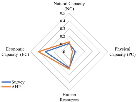
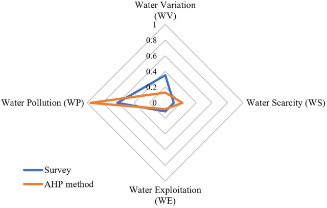
Radial Graphs 1 and 2 show the differences between the AHP and the survey, emphasizing economic capacity as the main parameter of adaptability and perceptions of water pollution as the prominent factor to generate water stress by both methods. There is a strong agreement between the experts’ evaluation and the community’s perception in the case of the ACI.
Source: author’s elaboration using Microsoft (2019).
Radial Graph 1 Product of CPi *wi using the survey analysis (blue) and the AHP method (orange) of simulating the Adaptive Capacity Index (ACI)
Source: author’s elaboration using Microsoft (2019).
Radial Graph 2 Product of CPi*wi using the simulation (blue) and the survey analysis (orange) of water stress (WSI)
In the WV and WP weights there are differences between the survey and AHP analyses. The difference in these weights indicate the differences in perceptions between the general population and the experts. For WV, the surveyed perceive a higher variability, however the historical and current hydrological values indicate that the variability is low. The community’s perception of higher variability may stem from a growing demand for this resource. On the other hand, WP is not considered relevant by the surveyed. This might be due to WP being a complex phenomenon with a positive feedback cycle, one that creates a significantly greater water scarcity, as it eliminates local water sources and diminishes the local ecosystem’s capacity to produce clean water.
4.2. Georeferenced results
Cuajimalpa is a diverse and complex space. Therefore, the values for WSI and ACI vary across this territory. Map 1 shows that most of the municipality is subject to ongoing and permanent water stress. The resource is not only overexploited, but also scarce and polluted. Further, some areas face a greater risk of disaster (scarcity, pollution and flooding).

Source: Fluxus, AA and BGS co-elaboration, 2020 (Arretche et al., 2021). Elaborated on ArcGIS 10.1 (Esri, 2016).
Map 1 Water Stress Index (WSI) in Cuajimalpa municipality
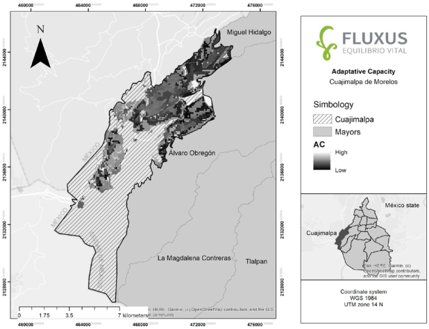
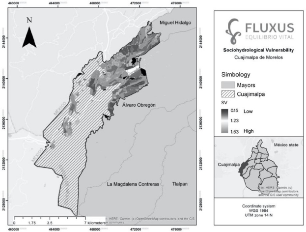
Map 2 reveals a significant adaptive capacity, which includes forests, grey infrastructure, the inhabitants’ skills and their economic level for confronting risks in Cuajimalpa. Map 3 shows the vulnerability index, identified in this text as SHV. The tendency is from moderate to significant in some areas, and thus the importance of strengthening resilience within the territory, preventing possible risks-disasters, and strengthening community ties to prevent conflicts. This figure also allows for considering eco-technologies and the possibility of knowing where to locate them and deciding which ones to use and how. Thus, these tools provide knowledge of the space that allows to differentiate, territorially, the processes of appropriation, use and management of the water resources.
Source: Fluxus, AA and BGS co-elaboration, 2020 (Arretche et al., 2021). Elaborated on ArcGIS 10.1 (Esri, 2016).
Map 2 Cuajimalpa Municipality’s Adaptive Capacity
Source: Fluxus, AA and BGS co-elaboration, 2020 (Arretche et al., 2021). Elaborated on ArcGIS 10.1 (Esri, 2016).
Map 3 Cuajimalpa Municipality’s Socio-hydrological Vulnerability
The social construction of space implies knowing its physical characteristics, and the influence social actors have on it, as well as the ways the territory influences its communities. Learning about Cuajimalpa has allowed us to understand the area’s proclivity for water stress. Even though it is a terrain with springs and wells, today it is undergoing significant water scarcity and pollution processes. If climate change is added as a key factor that has altered the rainy season, along with ongoing deforestation, a lack of reforestation, and increasing social tensions concerning water, Cuajimalpa in a few years could present severe water problems that are already evident in certain areas.
Even though adaptive capacity is still a key factor for reducing SHV, it is becoming evident that the social and spatial differences within this territory produce different ways of confronting risks-disasters from the perspective of infrastructure as well as that of human and economic resources. Although the municipality’s SHV is moderate at this time, it is highly probable that, if pertinent actions are not taken, conflicts and socio-hydrological problems will become more serious. This is because the development paths in the region will likely increase road construction and real estate development, thereby increasing the values of the parameters of the WSI (WP, WV and WS) while the values associated with the ACI (NC and PC) will tend to decline. In other words, the quotient WSI/ ACI will increase, producing a higher SHV.
Water vulnerability is a flexible tool that can be modified, based on several variables that change over time (weights, socio-spatial relationships, changes in the territory, or conflicts). Therefore, there are decisions that can be made that would contribute to strengthening adaptation-resilience. Hopefully, awareness of Cuajimalpa’s socio-hydrological parameters will promote thinking about the social construction of space and decision making in terms of the SHV, which is an area of growing concern both locally and globally (Conagua, 2021).
In relation to the parameters of the WSI, the search for much more specific data on water pollution is necessary, and this is a major concern for the area’s inhabitants. It is advisable to open the way for new research in this field which should consider the phenomena of urbanization, overpopulation and risk factors. In relation to the ACI parameters, it is essential to continue analyzing the importance of human resources, organization and social participation in matters related to water resources, as well as the territory’s socio-economic differences. The People and Water vision should be strengthened as a fundamental binomial in the face of scarcity-pollution. The analysis of environmental risk and the physical as well as the economic and social consequences related to climate change and other mega trends are relevant topics for future research.
Conclusions
In this study we have analyzed Cuajimalpa’s SHV using a mixed methodology. This allowed us to assess the municipality’s water stress and its adaptive capacity. The results show a moderate vulnerability in the area, where natural, physical and socio-economic conditions are relevant. Considering the social construction of the space allowed us to consider the possibilities for preventing risks-disasters, accelerating joint decision-making and the possible implementation of eco-technologies that can strengthen socio-water resilience.
In our view, vulnerability and adaptation must be related to a particular political context to allow the understanding of the power correlations and the economic and social characteristics of space which guides the use and appropriation of natural resources. Socio-economic differences in Cuajimalpa, spatial segregation, and a diverse urbanization process constitute elements to consider in the study of SHV.
Overall, Cuajimalpa has inefficient and centralized water management. Therefore, there are pending tasks related to the location and characteristics of eco-techniques and decentralized infrastructure for water resources. There is a need for greater emphasis on the study and analysis of water pollution, as well as community-wide organization, participation and deliberation on matters related to this resource.
Urban processes have led to increased use, exploitation, and contamination of water resources, and the population contrast in important economic and social differences has generated diverse forms of SVH that creates environmental inequity in this territory. The exercise carried out in the municipality is relevant for the CDMX water dynamics. The diversity of its economic activities, the potential of its human resources, the number of protected areas and water resources it has, as well as the socio-spatial inequality, makes it an ideal testing ground for putting into practice (mutually agreed upon) collective decisions, with a balance of interests (environmental governance) that will allow for strengthening adaptation-resilience.
The distribution of georeferenced socio-hydrological data makes it possible to identify the factors that define the vulnerability-adaptability when confronting disturbances related to the territory’s water resources. These factors combine with each other in such a way that some areas are more susceptible to change and others more resistant. Finally, it is important to highlight the need for SHV studies to be participatory, in order to make the right decisions about which actions should be taken.

