


 nueva página del texto (beta)
 Inglés (pdf)
 Artículo en XML
 Referencias del artículo
 Enviar artículo por email
 Citado por SciELO
  Similares en
SciELO
Similares en
SciELO 
 Permalink
1. Introduction
The little-studied Icaiche Formation crops out in southern Campeche, southern Quintana Roo, and southernmost Yucatán state, Mexico. It is worth noting that rocks equivalent or similar to those of the Icaiche Formation exist in northern Guatemala and northern Belize, but these have not been formally correlated.
This paper examines ways in which gypsum and probably argillaceous material of that formation may have exerted an outsize influence on the present hydrogeology and geomorphology of the Mexican portion of the Yucatán Peninsula, including all parts of the three states where the Icaiche Formation is present either at the surface or in the subsurface (Figure 1). This inclusive region is henceforth referred to simply as “Yucatán” unless that word is qualified to indicate the state of Yucatán. Exposure of Icaiche Formation rocks is sparse, and the contact relations with other formations (Figure 1) are incompletely known because of thick tropical vegetation, intense weathering, and limited road access. Furthermore, gypsum abundance can be obscured because its dissolution can produce a blanket of unconsolidated overburden by release of insoluble interbedded argillite. Abundant gypsum can contribute to especially rapid weathering in areas of moderate to high pre-cipitation like southern Yucatán, where average annual rainfall is 1100-1600 mm/year (Dunning et al., 2012; Dunning et al., 2016). This enhanced weathering occurs because, the solubility of gyp-sum is several times greater than that of calcite, except at low pH.

2. Stratigraphic relations in the part of the Yucatán Peninsula within Mexico
2.1. The icaiche formation and its gypsum member
The stratigraphic framework for Yucatán geology was established by Jacques Butterlin and Federico Bonet who made an extensive field study of the area between 1958 and 1960 (Butterlin and Bonet, 1960). Lacking identifiable fossils for correlation, they used the presence of bedded evaporite as the defining characteristic of the Icaiche Formation. The importance of this characteristic will be emphasized here. The outcrop boundaries of the Icaiche Formation within Mexico, shown in Figure 1, conform to those in the map of the Estados de Campeche, Quintana Roo y Yucatán, 2007 (SGM, 2017). Note that it is probable that Icaiche rocks continue south into Belize and Guatemala (Flores, 1952).
The Icaiche Formation consists of Paleocene-lower Eocene lagoonal rocks whose detailed stratigraphy is indeterminate because recrystallization has made fossil correlation difficult. Despite poor exposure, it is possible to use the quarry symbols on the map of SGM (2017) to define an outcrop area of about 10000 km2, which is centered on Xpujil, Campeche to approximate the minimum area of surface exposure of Paleocene-Eocene bedded gypsum within Yucatán. This area is shown by the rectangle labelled “Outcrop Area of Gypsum Member” in Figure 1. We shall refer to these gypsum beds informally as the gypsum member (GM) of the Icaiche Formation. In the region where it is exposed in outcrop, the GM has an estimated minimum thickness of at least 25-35 m as discussed below. Figure 2 is a generalized stratigraphic column that includes the rocks discussed in this paper.
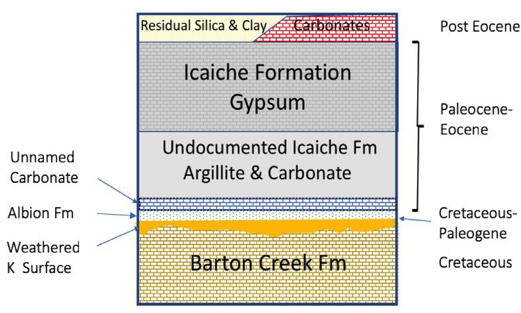
2.2. Cretaceous barton creek formation and basal paleogene albion formation
In Yucatán, the Icaiche Formation is underlain by two older formations: 1) the Barton Creek formation part of the Yucatán Group of Upper Cretaceous shallow carbonates and evaporites (Viniegra-O., 1981; Peterson, 1983) and 2) the transitional Cretaceous-Paleogene Albion Formation, consisting of a thin blanket of partially cemented air-fall material from the terminal Cretaceous Chicxulub bolide impact that rests disconformably atop a highly weathered surface of Barton Creek formation dolomite (Pope et al., 2005). A single contact of the Albion Formation with weathered, white, micritic Paleogene dolomite overlying pink and tan, thin-bedded, micritic limestone has been identified by Pope et al. (2005) at Agua Dulce (Figure 1), but that Paleogene unit has not been definitively correlated with the Icai-che Formation.
Exposure of the Barton Creek formation in the study area (and thus in Mexico) consists of only two outcrops (Pope et al., 2005). The largest of these includes the Johnson quarry (18.516° N, 88.485° W), about 20 km west of Chetumal in a block uplifted along the Río Hondo Fault (Figure 1). The other exposure, near Ramonal (Figure 1) is a small outcrop beneath weakly consolidated Albion Formation rocks. Although small, this outcrop is significant because it clearly shows that the upper surface of the Barton Creek formation is strongly altered “deeply weathered [...] dolomite with iron oxide staining, calcite veins, and abundant solution cavities” (Pope et al., 2005). The Albion Formation is exposed in numerous other places along the Ucum-Álvaro Obregón highway (which parallels the Río Hondo Fault and the coincident Belize border) (Pope et al., 2005). Thus, the Barton Creek formation can also be inferred to be present at shallow depth along the highway. A large additional outcrop of both the Barton Creek formation and the Albion Formation occurs along the projection of the Río Hondo Fault at the Albion Island quarry in Belize (labeled Barton Creek in Figure 1) (Pope et al., 2005).
2.3. Icaiche formation structure and overlying rocks
The Icaiche Formation forms part of an anticline that plunges gently to the north. The Formation crops out over much of southern Campeche and southwestern Quintana Roo; however, in the state of Yucatán the Icaiche Formation is present almost entirely in the subsurface; it crops out on the surface only in the southernmost part of the state (Figure 1).
On the north, east, and west of its main area of outcrop, the Icaiche Formation is overlain directly by the Eocene Chichen Itza Formation, by the Pliocene Carrillo Puerto Formation, by bits of Miocene rocks, and by alluvium mapped as Quaternary. Even where no unconsolidated material is mapped, the Icaiche Formation is blanketed by a variably thick layer of soil and smectitic clay that may be both a residuum of the formation and the product of gradual aeolian deposition that has contributed parent material to the soil cover across the Peninsula throughout the Quaternary. Sources for the latter material include ash from various Central American and Mexican volcanoes, Saharan dust, and North American loess (Sedov et. al., 2008, Cabadas-Baez et al., 2010; Bautista et al., 2011; Tankersley et al., 2015, 2016).
The area over which the Icaiche Formation crops out ranges in elevation from about 50 to 300 m above mean sea level (msl) and is included within a somewhat larger physiographic region referred to as the Elevated Interior Region (EIR) of the Maya Lowlands (Dunning et al., 2012). The EIR marks an area in which practical reasons related to geology and soil types dictated a distinctive Maya style of agriculture and water management that is, in many cases, closely related to the outcrop or shallow subcrop pattern of the Icaiche Formation (Figure 1). Therefore, for convenience, we will adopt the term EIR to designate the major region of focus for this study. We do this in part to emphasize the unusually clever adaptation here by humans to constraints imposed by regional geology. From the perspective of human occupation, the geologic features that most readily distinguish the EIR from northern Yucatán are the “abundance of soil and of gypsum over much of the area” (Gunn et al., 2002), “and the absence of an accessible fresh water lens in hydraulic equilibrium with the ocean” (Perry et al., 2011). These features combined to create, in the EIR, a harsh land, whose soil, although arable, is easily poisoned by water contaminated with sulfate derived from dissolving gypsum. A further problem for farming arises from wide variation in precipitation that can alternately flood and desiccate fields. Despite this bad groundwater and variable climate, the Maya survived and sometimes prospered in this environment for nearly two millennia -between 1000 BCE and about 925 CE, from the Middle Preclassic to Late Terminal Classic periods (Castellanos and Foias, 2017). These environmental challenges arguably were a driving force behind ancient urbanization in the EIR, as populations organized to meet collective water management needs (Dunning et al., 2016). By about 950 CE the Maya left and did not return except around areas with perennial water supplies (Dunning et al., 2012; Beach et al., 2015a).
As discussed further in Section 5.1, although the fit between geology and Maya culture and technology developed in the EIR is imperfect, it is about as good as is possible to determine given our present state of geologic/hydrologic knowledge. This limiting knowledge is illustrated by reference to Figure 1 of a review paper by Beach et al. (2015a) that outlines some 16 geomorphic sub-regions within the states of Yucatán, Campeche, and Quintana Roo. Of these regions, only sub-region 7, encompassing the Puuc cities Uxmal and Sayil (section 5.1) and sub-region 10, a polje (section 4.3), fall comfortably into environmental patterns for which we can currently offer specific limiting geologic/hydrologic explanations.
3. Discussion
3.1. Importance of gypsum and argillite in the elevated interior region to geomorphology and human activity
Despite the paucity of geological information about the EIR, we think the knowledge available is adequate to draw useful inferences about how the geology of its rocks, especially the Icaiche formation, have influenced the geomorphology and hydrogeology of the Peninsula. Furthermore, we hope this study will provide some general insight into the importance that gypsum and interbedded argillite can have in forming landscapes under varying conditions of weathering. Because available data are limited, our conclusions will necessarily be tentative but may be useful for further investigation. We will draw on several observations: 1) the extensive size and thickness of the GM; 2) the definitive evidence provided by systems of water storage, successfully used in Classical Maya times, that required a thick residual cover of impermeable argillaceous clay (much greater than what is present in the northern lowlands); 3) the qualitative outcrop information about the abundance of argillaceous material in the Icaiche Formation. 4) the knowledge from drill core (Lefticariu et al., 2006) that weakly consolidated Albion Formation impact ejecta containing a significant quantity of devitrified glass (Pope et al, 2005) underlies the Icai-che formation; 5) the distinctive mapped patterns of interior drainage systems that are labeled poljes on the SGM (2017) (Perry et al., 2009; Perry et al., 2011); 6) the distinctive karst forms present near the northern Peninsular coast in Yucatán state that are consistent with dissolution of deeply buried gypsum (Socki et al., 2002; Perry et al., 2009); and 7) the facies changes in younger rocks of eastern Quintana Roo, possibly related to transport of argillaceous sediment to the coast (Leal-Bautista and Cejudo, 2017).
EIR agriculture depended on abundant impermeable clay required by Mayas of Classical times to construct extensive systems of canals, dams, and reservoirs to compensate for absence throughout the region of reliable sources of potable ground-water (Matheny, 1976; Matheny et al., 1983; Gunn et al., 2002; Domínguez and Folan, 1996; Dunning et al., 2012; Beach et al., 2017; Dunning et al., 2016). Abundant layers of clay in the region also serve as natural aquitards for shallow perched lakes such as Lake Silvituk (Perry et al., 2011). There are probably multiple sources for this surficial clay as mentioned in section 2.2. Much probably came, at least directly, from weathering of local bedrock, but, whereas bedrock over most of the area is the Icaiche Formation, the northwest corner, including important archeological sites such as Uxmal, are located on the Eocene Chichen Itza Formation (section 5.1).
One argument suggesting that the Icaiche Formation is an important source of surficial clay in the region (and perhaps the ultimate primary source) is that the pervasive saline intrusion penetrates only slightly south of the northern fringes of the EIR (Perry et al., 2009; Perry et al., 2011), as discussed further in section 5. This indicates that carbonates of the Icaiche Formation are significantly less permeable than the carbonate rocks of the north, presumably as a result of increased argillite content. Another possible argillite source is siliceous material both within and beneath the GM, as discussed in section 3.3.
3.2. More active when wet: interaction of gypsum with groundwater
To advance our suggestion that the GM has had a disproportionate influence on the surface geological processes in Yucatán, we shall first present evidence that bedded gypsum is continuous in the subsurface to the north of the present area of outcrop (all the way to the north coast of Yucatán state) and therefore that the GM, which occurs in the vadose zone in its area of outcrop, is present beneath the water table farther north. The relation of a layer of gypsum to the water table is important because the behavior of gypsum as a geological agent depends on the hydrology of its environment. It is worth emphasizing that, as noted above, except in acid water, gyp-sum solubility is greater than carbonate solubility (often by an order of magnitude) and that, unlike carbonate solubility, it is little affected by the pH changes produced by decaying vegetation in associated soils.
Within the vadose zone, i.e. primarily in the area over which the GM crops out, gypsum responds to water from rain merely by dissolving, thus contributing to local relief, and disappearing from outcrops. The chemical effect of vadose zone dissolution is the addition of sulfate and calcium ions to runoff and groundwater. The added sulfate can have important environmental effects, but, in carbonate terrains, addition of calcium is likely to be important only for secondary chemical reactions related to common ion precipitation. However, gypsum behavior below the water table can be particularly important if groundwater is flowing. If not initially saturated, water flowing through channels in bedded gypsum will obviously open those channels, enlarge voids, and provide positive feedback for further subsurface dissolution of gypsum, calcite, dolomite, and other minerals and for transport in suspension of silicates, especially argillite. These processes, working together, can produce subsurface erosion and collapse. They may also add sediment at the point of discharge.
3.3. Outcrop extent and thickness of the gypsum member
Access to EIR geology improved significantly in 2009 when widening and partial levelling of the Mexican Highway 186 occurred. This road crosses most of the Yucatán Peninsula at approximately 18.5° N and essentially bisects the outcrop area of the GM, exposing important new outcrops of massive gypsum beds. The teeth of excavating equipment (used in the highway construction) have left distinctive impressions in these soft gypsum beds, making them easy to identify and follow for several kilometers. This suggests a possible novel application of the well-known website Google Earth “Street View” where prominent gypsum outcrops can readily be identified in highway traverses. For example, one of the most informative outcrops along the highway occurs at and near coordinates 18.530° N, 89.576° W (Figures 1 and 3). There, stacked beds (each individual bed about a meter thick) of coarsely crystalline, gently folded gypsum are outlined by thinner beds of clay. Displacing the bedded gypsum at this outcrop there are what appear to be two “intrusions” of a very poorly sorted siliciclastic rock consisting of an argillite matrix supporting much coarser rock fragments. In a second nearby outcrop (Figure 4), blocks of gypsum rock (more than a meter in maximum dimension) “float” in a similar silici-clastic intrusion, emphasizing the fluidity of the siliciclastic material. In a quarry that is on the opposite side of the hill from the exposure shown in Figure 3, there is an exposed wall of about 25 m of coarsely crystalline gypsum (Figure 5). In 2008, a slump on the west side of that wall was exposed to view (Figure 6). The highly deformed beds in that outcrop, outlined in red clay, are a further indication of mass movement probably lubricated by water. (This slump structure has subsequently been removed by quarrying.)
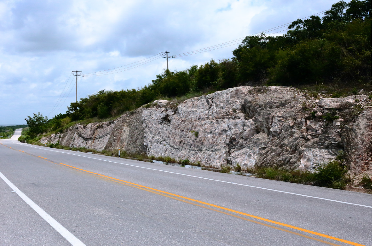
Figure 3 Roadcut in massively bedded gypsum layer of the Icaiche Formation along Highway 186. Note “intrusions” of poorly sorted argillite. At 18.530° N, 89.576° W. Labeled “Prominent Gypsum Outcrop” in Figure 1.
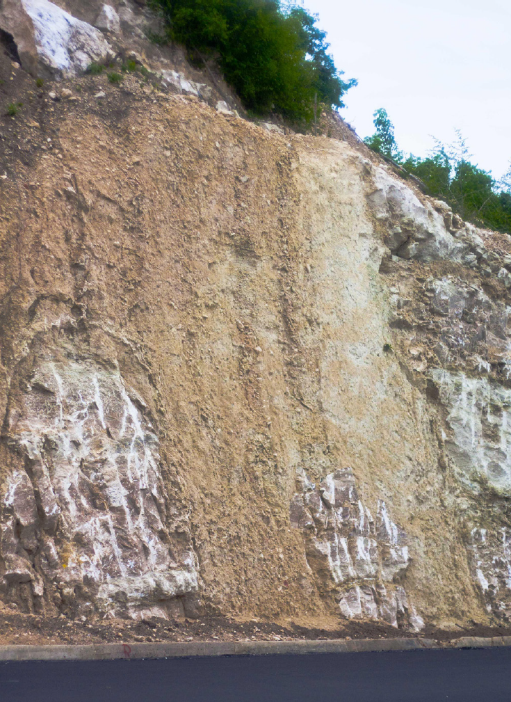
Figure 4 Blocks of massive GM caught up in poorly bedded argillite, part of the same outcrop as in Figure 3 and about 50 m east of that outcrop. Note distinctive tooth marks of the excavating equipment that identifies soft, ductile gypsum and can be used for a virtual field trip along Highway 186 in Google Earth “Street View.”
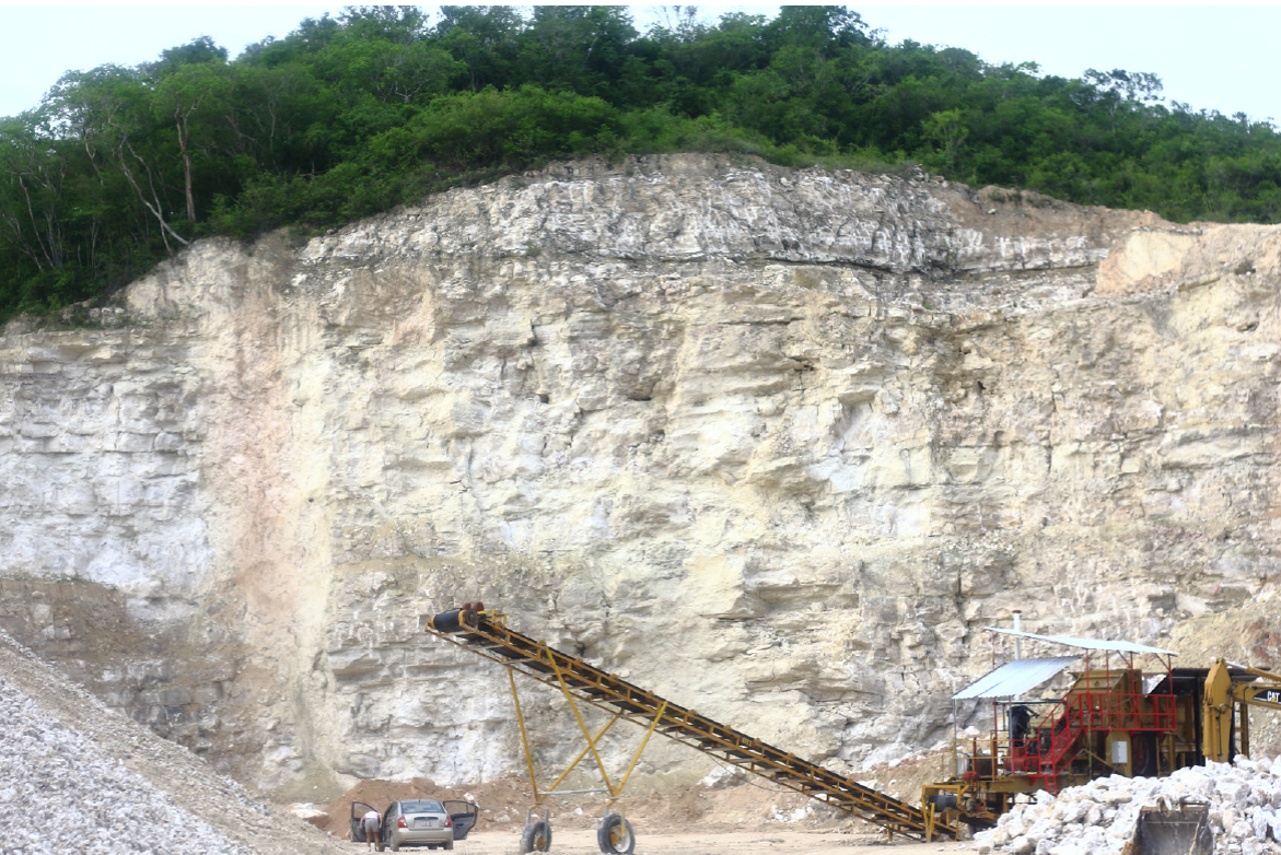
Figure 5 A wall of massively bedded gypsum of the GM of the Icaiche Formation exposed in a quarry 500 m west of Figure 3. Estimated thickness: 25 m. Photograph taken in 2008.
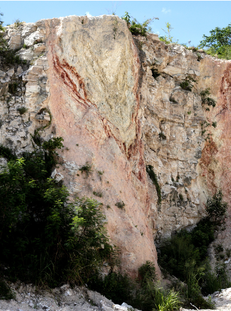
Figure 6 A slump structure in the same quarry as shown in Figure 5. The feature had been excavated, hence removed, before the photograph of Figure 5 was taken.
A definitive estimate of the thickness of the GM is not possible, because complete outcrops are lacking. We estimate a minimum thickness of 25-35 m based on the following: 1) an estimate of 25 m exposed in the quarry face in Figure 5; 2) a quarry of similar size in which excavation has proceeded in stages giving only a general impression of thickness; and 3) the 35 m thick subsurface occurrence of massive gypsum in drill core UNAM6 described by Lefticariu et al. (2006), which, as noted in section 4.2, we correlate with the GM of the Icaiche Formation.
4. Regions arguably affected by surface or subsurface weathering of gypsum of the Gypsum Member
4.1. Living on a gypsiferous substrate: constraints on human activity from sulfate-contaminated water
The effect of gypsum on the groundwater of the EIR is profound. This is one of the major reasons why this region has remained almost unpopulated for about a thousand years after it was abandoned. It is quite remarkable that a large population could once have accommodated to local conditions by developing facilities for capturing and storing rainwater during the Maya Classic period. The Maya, living in the EIR, were able to develop these storage and distribution facilities for rainwater because of the presence of impermeable clay layers that do not exist in the better known coastal area of Campeche, Yucatán state, and Quintana Roo. The clays cover the floor of shallow karst depressions (bajos), which the Maya extended and deepened (and also imitated) to form large reservoirs (Matheny et al., 1983; Gunn et al., 2002; Dunning et al., 2012).
Analyses of water from Lake Silvituk and Lake Zoh by Wagner (Wagner, 2009; Perry et al., 2011) are presented in Table 1 and show that shallow lakes (and by extension modified bajos of the Maya) can store remarkably ion-free water. Water from Lake Zoh (Table 1) is of special interest because it is within only a few hundred meters of a town well that pumps water with a sulfate concentration too high for human consumption. The EIR extends across the Mexico-Guatemala border. Near its southern margin (at El Palmar in Petén, Guatemala), water held in a lake (Cival) above a clay layer has similarly low sulfate, whereas underlying groundwater in an aquifer confined by the clay layer has high sulfate (Beach et al., 2015b).
Table 1 Water bodies and wells within or at the eastern part of the EIR. Data from Wagner (2009) and Perry et al. (2011).
| Sample | Latitude (º N) / Longitude (º W) | Chloride (mEq/L) | (mEq/L) | 100xSO4/Cl | |
|---|---|---|---|---|---|
| La Guadalupe Well | 18.33 / 89.48 | 16.29 | 36.46 | 224 | |
| La Guadalupe Spring | 18.33 / 89.48 | 9.93 | 32.41 | 326 | |
| Zoh Well | 18.59 / 89.42 | 7.9 | 31.49 | 400 | |
| Zoh Lake | 18.59 / 89.42 | 0.23 | 0.03 | 13 | |
| Lake Silvituk | 18.63 / 90.31 | 0.2 | 0.04 | 20 | |
| Nuevo Israel Well | 19.00 / 88.57 | 6.1 | 25.1 | 414 | |
| Lake Chichancanab | 19.84 / 88.76 | 7.4 | 52.9 | 712 |
Today, despite efforts by the Mexican federal government and by the government of Campeche to resettle the EIR, the area remains one of the least populated parts of Yucatán, mostly because of the lack of potable water. In a resettlement program, initiated by the Mexican government in the 1960s (Ericson et al., 1999), farmers from densely populated parts of Mexico were brought to this area. One resettlement community, La Guadalupe, consisting of 282 people (Navarro-Olmedo, 2016), has a hand-dug town well in which the sulfate content is about 6 times US-EPA standards for human consumption (SDWA,1996) (Table 1). Near this well, there is a spring in which gypsum crops out in direct contact with spring water. Water from this spring is similar in chemistry to the town well (Table 1). Residents of La Guadalupe rely on drinking water furnished by CONAGUA, the National Water Commission of Mexico, and brought by tank trucks. CONAGUA also supplies water (obtained outside the region) to the municipality of Xpujil, the major population center of the region, through two pipelines: one (57 km long) brings water from Lake Alvarado, the other (100 km long) brings water from Constitución.
A drought in 2005 (Proceso, 2005) demonstrated that water supply is almost as tenuous today for the 28000 inhabitants of Calakmul County, as it was for the Maya of the Classic period (Dunning et al., 2016). In that year, rain-fed Lake Alvarado dried up causing real hardship in the region. CONAGUA responded by drilling a supply well in the southeast, just outside the area of contaminated water, and sending the water to Xpujil through the Alvarado pipeline.
4.2. The pockmarked terrain: a distant karst area probably affected by buried gypsum member rocks
A second way in which the Icaiche Formation affects geomorphology and hydrogeology of the northern Yucatán Peninsula is not obvious because it occurs far from the nearest Icaiche outcrop. It is probable that the GM of the Icaiche Formation is responsible for the development of the distinctive form of karst, characterized by a dense population of deep cenotes and aguadas, that constitute the Pockmarked Terrain of north central Yucatán state (Perry et al., 2002), about 160 km north of the nearest Icaiche outcrop.
Please note that the regional nomenclature for karst depressions is somewhat variable and can be ambiguous. Here, we use the word cenote (from the Maya tzonot) to refer to a specific type of water-filled sinkhole common in northern Yucatán (Schmitter-Soto et al., 2002). We specifically invoke the implied but generally unstated condition that all these northern cenotes have a subsurface hydraulic connection with the ocean and with each other, tapping into a regional water table controlled by msl. The distinction is important in discussion of Cenotes Ucil and Xcolak in this section and particularly in section 6, where we discuss Cenotes Ocom and Nohbec. The latter cenotes differ distinctly from neighboring water bodies that are perched lakes not in equilibrium with the ocean. We use aguada to specify a sinkhole that is partially filled with sediment that blocks its direct connection to the regional water table. In other discussions of southern parts of the EIR, this usage may differ.
The presence of the GM gypsum more than 100 m beneath the surface in the Pockmarked Terrain was inferred by Gmitro (1986), Perry et al. (2002) and Socki et al. (2002). This assumption was based on high sulfate and strontium ion content of the water at the base of the water column 100 m-deep in Cenote Ucil (20.990º N, 88.600º W) and 120 m in Cenote Xcolac (20.909º N, 88.857º W), also spelled Xcolak and Xkolac. It is worth mentioning that strontium, a minor element present in gypsum of marine origin, is a better groundwater tracer element for gypsum (CaSO4•2(H2O)) than either calcium, which is ubiquitous in carbonate-saturated groundwater, or sulfate, which is readily reduced to sulfide by organic matter in sinkhole water. Correlation of the subsurface gyp-sum of the Pockmarked Terrain with the GM is also supported by the presence of a 35 m layer of recrystallized massive Paleocene/Eocene gypsum overlying Paleocene collapse breccia in rock core from UNAM6, an observation well drilled near Peto, 50 km north of the nearest Icaiche Formation outcrop (Lefticariu et al., 2006).
A mechanism for producing the deep sinkholes of the Pockmarked Terrain is provided by the discovery of a set of ring fractures along the eastern edge of the Chicxulub Impact by offshore seismic measurements of Gulick et al. (2008). As set forth by Perry et al. (2009), these deep fractures may provide a pathway for groundwater movement, especially during times of lower sea-stand. Here is how Perry et al. (2009) explained why karst development of gypsum would be more likely in a deep, saline intrusion than development of limestone karst in that environment. The shallow pre-Paleogene basement faults reported by Gulick et al. (2008):
...may have resulted in exceptional permeability development, opening this zone to extensive groundwater penetration. The enhanced permeability, of itself, may have been sufficient to produce subsurface dissolution of both carbonates and evaporites. However, in contrast to carbonate dissolution, solubility of gypsum, anhydrite, and celestite is not directly pH dependent and thus is perhaps more likely to take place within the saline intrusion, well below the water table, if deep groundwater circulation occurs. In that case, expansion accompanying hydration of anhydrite may have preceded and accelerated dissolution of gypsum associated with impact ejecta [or more probably GM] to produce the subsurface erosion that contributed to collapse features in the area.
In summary, given the extensive surface exposure of the GM and our ability to trace it northward in the subsurface, we consider the dissolution of buried Icaiche Formation gypsum the most likely mechanism by which the unique Pockmark Terrain developed 160 km from the nearest Icaiche outcrop.
4.3. Poljes, probably formed by subsurface dissolution of gypsum
A third geomorphic/hydrogeology result of the GM dissolution may have been the formation of the poljes of Southern Campeche and Quintana Roo. These are closed, often interconnected basins that are 40 km or more in their longest dimension (Figure 1) (SGM, 2017). They are floored by residual clays derived from the weathering of aeolian inputs and insoluble residues of limestone weathering. They also have complicated internal drainage patterns that do not seem to “go anywhere,” at least on the surface. They offer agricultural potential in the form of water storage and thick (although nutrient-poor) soil. But this potential has not been exploited everywhere because it is often counterbalanced by the seasonal tendency toward flooding during rainy periods and desiccation during drought (Gunn et al., 2002; Dunning et al., 2012). However, the development of aprons of cumulic, base-rich soils derived from soil erosion on adjacent uplands on the footslopes and toeslopes bordering many low lands (bajos) created zones with high productive potential that were exploited with intensive cultivation (Dunning et al., 2002, 2006, 2015). Swampy areas and thick vegetation can impede access, a fact made clear by the name of one of the most extensive poljes: “Sal Si Puedes (get out if you can)” (Figure 1).
Except for what evaporates, rainwater falling on these poljes must leave through some sort of drain, and both the volume of accumulated residual sediment on the valley floor and the mass lost to form the depressions require that large amounts of material were transported in solution and suspension out of each basin. A question that arises is what is their plumbing system? We suggest it is not a coincidence that the large poljes of the region are located on or adjacent to the outcrop area of the Icaiche Formation with its near-horizontal beds of gypsum. We submit that the poljes were formed by underground dissolution of gypsum, which opened subterranean passageways carrying water, dissolved limestone and suspended siliciclastics out of the EIR region, followed by collapse of rocks above creating something analogous to enormous sink holes. The poljes of Turkey and elsewhere in Eastern Europe and the Middle East are commonly associated with evaporites (Doğan, and Yesilyurt, 2004). In support of this mechanism, Laguna Om (18.49° N, 89.08° W) drained rapidly and unexpectedly and then quickly refilled in August, 2018 (Leal-Bautista, personal observation). Lake Om lies about 2 km east of a north-south line of gypsum quarries and is part of a chain of shallow lakes about 10 km long, trending NNE-SSW, more or less paralleling faults in southeastern Quintana Roo. It is at the southwestern junction of intersecting Poljes Nuevo Becak and Morocoy. Leal-Bautista is investigating the possibility that this lake drainage is part of a continuing subsurface drainage process by which the joint Poljes Nuevo Becak-Morocoy is becoming extended.
4.3.1 Possible fate of siliciclastic residues of polje formation
We assert that the “intrusions” of unsorted, dominantly siliciclastic sedimentary material into bedded evaporite of the GM (Figures 3 and 4) must have been emplaced as mobile, water-rich fluids. Probable source materials include: 1) argillite interbedded with gypsum in the GM (red layers in Figure 6 and the dark layer in Figure 3); and 2) argillite derived from devitrified glass of the Albion Formation (Pope et al., 2005). This suggests an answer to an apparently unrelated question: What is the source of impermeable clay in post-Eocene sedimentary marine rocks deposited to the east of the EIR? Section 6 describes characteristics of these younger carbonate rocks indicative of relatively high argillite content. For example, the Miocene Estero Franco and Bacalar Formations and, in particular what may be a local, low-perme-ability facies of the Carrillo Puerto Formation all support perched water tables. We suggest that the material in the intrusions shown in Figures 3 and 4 may be representative of siliciclastic insoluble residues removed during the process of subsurface erosion that formed poljes and that these sediments were subsequently incorporated into carbonate sediments being deposited offshore.
5. The Ticul Fault
5.1. The ticul fault, a useful but inexact marker of hydrogeological regions
In 1970 Back and Hanshaw proposed that the aquifer system of the northernmost Yucatán Peninsula consists of a lens of fresh water floating on a denser saline intrusion within a permeable carbonate aquifer. That model was developed by Hanshaw and Back, (1980) and Back et al. (1986) and has been tweaked many times by numerous investigators in the ensuing 47 years; but it remains generally valid.
Perhaps reflexively, it has become easy to envision the hydrogeology of the entire Mexican part of the Yucatán Peninsula as fitting a variation of the Hanshaw and Back (1980) model, but that is wrong. There is no evidence for a saline intrusion beneath outcrops of the Iaiche Formation (Perry et al., 2011). However, the precise boundary between the permeable rocks in the north (that support a saline intrusion) and the rocks in the south (that do not support it) is difficult to establish. Dunning et al. (2012) have used the Ticul Fault as the northern boundary for the EIR, and that is a valid divider for archeological purposes (Beach, 2017). The ruins of a group of Maya cities that is noted for distinctive Puuc style architecture, occupies the northwest corner of the EIR. These impressive cities, including Oxkintoc right on the fault, Uxmal (14 km south of the fault), and Sayil (21 km south of the fault) flourished between 700 and 950 CE. Their residents did not have access to groundwater, and in that sense these cities were like the southern cities of the EIR and were utterly dependent on capturing and storing rainwater. However, the Puuc cities were built on the porous, permeable rocks of the Chichen Itza Formation that does support a saline intrusion and has an aquifer, which, although it was too deep to be accessible by pre-Colonial technology, now supplies groundwater to deep wells at Uxmal and Sayil (Perry et al., 2002). For reference, the water table in nearby Santa Elena (10 km south of the Ticul Fault) lies at a depth of 92 m (Perry et al., 2002).
5.2. The ticul fault as a conduit for groundwater flow
The up-thrust southern block of the normal Ticul Fault of Eocene age (McClain, 1997) is a conspicuous, well-defined landmark in south central Yucatán state, rising directly south of its eponym, the town of Ticul (20.40° N, 89.535º W), to a height of almost 100 m above the down-dropped, flat lowland plain of northern Yucatán. This scarp, which forms the northern boundary of the southern block and of the EIR, continues to dominate the landscape as far as Tzucacab (20.206º N, 89.290º W), 60 km southeast of Ticul (Figure1). The fault is an important conduit for groundwater movement, carrying water from the vicinity of Lake Chichancanab (19.840º N, 88.760º W) westward to the fault system that surrounds the Chicxulub impact and thence into the Celestun Estuary and the Gulf of Mexico (Perry et al., 2002; Perez-Ceballos et al., 2012). The Ticul Fault is important to an understanding of the geomorphic importance of the GM because, as we show in the next section, it is the major conduit by which sulfate (a proxy for dissolved gypsum) has been transported out of the region around Lake Chichancanab.
5.3. Dissolution of gypsum below the water table: a simple model to explain ongoing evolution of a complex geomorphic region
In the 16 km, between Tzucacab (20.070º N, 89.050º W) and Catmis (19.960º N, 88.950º W) (Figure 1), the exact position of the Ticul Fault becomes difficult to discern in the field. Consequently, the fault trace is marked in the map of SGM (2017) (and correspondingly on Figure 1) as a dashed line. We think it is significant that, within that distance, there is also a notable change in groundwater chemistry. Groundwater from Tzucacab has a SO4/Cl equivalent ratio of 1.03, whereas the ratio at Catmis is 1.8, with corresponding SO4 equivalent concentrations of 12.1 and 19.7 mEq/L, respectively (Perry et al., 2002). Both, these sulfate concentrations and SO4/Cl ratios, are high and strongly suggest groundwater contact with a sulfate source (gypsum). Southeast of Catmis, the map of SGM (2017) continues to show a dashed trace (denoting uncertainty) for the Ticul Fault for 120 km to Cenote Nohbec (19.100º N, 88.210º W) and beyond. This section of the fault passes by the southern end of Lake Chichan-canab, whose water is approximately saturated with respect to gypsum (Perry et al. 2002; Hodell et al., 2005).
Perry et al. (2002) used water chemistry and lake elevation as a basis for postulating that ground-water from the vicinity of Lake Chichancanab moves west through the Ticul Fault into the Gulf of Mexico. Combining information on the map of SGM (2017) with these previously reported geochemical data, we can now make stronger statements: 1) It is highly probable that GM is present in the shallow subsurface of this area as it is in much of the northern Peninsula, and also that 2) groundwater moving through the Ticul Fault is actively dissolving gypsum of this unit and removing it -in effect performing a natural analog of “solution mining”. Evidence for the aforementioned can be best evaluated by referring to regional characteristics summarized in Table 2. Removal of gypsum by dissolution can explain the common occurrence of calcareous breccia noted on the map of SGM (2017) in quarries flanking the Ticul Fault trace (much more abundant on the down-dropped northern side).
Table 2 Features related to the transitional hydrology of the eastern “Ticul Fault Zone”.
| Feature | Location or Entity | Possible Significance | Notes | |
|---|---|---|---|---|
| Noted on the map of SGM (2017) for quarries in a band | ||||
| “Calcareous Breccia” | east and west of Ticul Fault trace and south of Catmis. | Suggests collapse related to subsurface gypsum dissolution. | Also notable in street and road cuts in and around the town José María Morelos. | |
| Quarries are predominantly, but not exclusively in Carrillo Puerto Fm. | Indicates hydraulic contact with an aquifer whose level is controlled by the ocean (msl). | Measured on Google Earth. | ||
| Surface water level elevation within about 4 above msl. | Lakes Esmeralda and Chichancanab, Cenotes Ocom and Nohbec. | Water in direct contact with gypsum. | Lake Esmeralda measurement reported in Perry et al . (2002). | |
| Water saturated or nearly saturated with gypsum. | Lake Chichancanab 19.840º N, 88.760º W | Indicates slow (months, years) but regular (longer scale) response to sea level change. | Reported by Perry et al. (2002). | |
| Gypsum precipitating on shore. | Lake Chichancanab 19.840º N, 88.760º W 19.142º N, 88.168º W. | Suggests that a relatively impermeable facies of the Carrillo Puerto Fm once supported perched stream flow above msl. | Hodell et al . (2005) | |
| 9000-year record of climate and of lake elevation. | One arm of Cenote Nohbec is on the Ticul Fault trace. 19.470º N, 88.100º W | Ocom is within a meter of msl. | One of several “fossil” stream channels evident on the map of SGM (2017) and on Google Earth Best example of stream captured by base level (msl) aquifer. | |
| Nohbec: a cenote in the form of a meander, sitting on the Carrillo Puerto Fm. | Show clearly on NASA Image PIA03379. Indicates surface movement over low permeability rocks. | Illustrate permeability (facies) change in the south of the Carillo Puerto Fm. | ||
| Chain of cenotes, including Ocom, occupying the channel of a “fossil” meandering stream. | Can be observed in Google Earth | |||
| Channels for overland flow into Cenotes Ocom and Nohbec. |
Calcareous breccia is also abundant in outcrops within the town of José María Morelos (JMM) and in road-cuts near the town. We suggest that these are collapsed breccias above caverns produced by gypsum dissolution. Water chemistry provides additional evidence of heterogeneous distribution of gypsum in the subsurface in the vicinity of JMM where residents queried by Perry (unpublished personal observation, 2013) reported wide local differences in the quality of well water. This variability is documented (Perry et al., 2002) in a pair of wells near the fault trace and about a kilometer apart at Chunhuhub (Figure 1). The SO4/ Cl ratio measured for water in the Chunhuhub town well was 1.74, whereas the ratio for water in a nearby well at an agricultural station was 9.01. The respective sulfate concentrations were 7.29 and 18.93 mEq/L. This high local variability in the concentration of sulfate in groundwater suggests that removal of gypsum by dissolution is an active, ongoing process.
It is worth noting that sulfate is a strong laxative, and high sulfate values are deleterious to a number of crops. The lower value exceeds Mexican (NOM- 127 SSA-1994) and US standards for drinking water (SDWA,1996), and the higher value is one of the highest measured in waters of Yucatán. As noted above, the trace of the Ticul Fault is projected to run through Cenote Nohbec, which has a water elevation of 1-2 m above msl according to Google Earth (accessed 28/02/2018). That confirms Lake Chichancanab (elevation 4 m) as a groundwater divide and suggests why the Ticul Fault is a strong transport agent removing gypsum from the region. In fact, the 50 m.y. Eocene fault is considerably older than the 5 m.y. Pliocene Carrillo Puerto Formation that overlies the fault divide in this region, suggesting that the diffuse path of the fault here is visible precisely because it is projected up to the surface as a result of subsurface erosion of underlying gypsum.
Several regional geomorphic features (Table 2), which probably developed during a period of pre-modern precipitation, suggest that post-Eocene rocks bordering the EIR on the east are sufficiently impermeable as to constitute aquitards. These include meander-like features, resembling “fossil” stream channels that are filled by permanent or ephemeral bodies of open water, several meters or more above msl. Most of these do not appear to be influenced by karst processes. However, one apparent fossil stream channel, that is particularly helpful in interpreting an evolving landscape, is occupied by Cenote Ocom (Table 2), which is one of eight cenotes that have water elevations of approximately 1-2 m above msl . These cenotes all occupy a sinuous basin, labeled “Lake Ocom” in Figure 1 (19.47º N, 88.07º W), that resembles a stream meander as can be seen clearly in Google Earth. We interpret this assemblage as recording the history of a perched stream that has been let down by erosion to modern base level.
A reconnaissance inspection of local quarries (Leal-Bautista and Cejudo, 2017) confirmed that layers of expanding clay are common in local rocks, including rocks of the Carrillo Puerto Formation, which is more permeable in northwestern Yucatán than here. One possibility, proposed in section 4.3.1, is that these eastern, post-Eocene rocks contain considerable argillaceous material eroded from the EIR and transported eastward as the younger rocks were deposited. Provenance studies could usefully test this suggestion. The significance of these observations is that the presence of aquitards above the GM may have protected layers of gypsum in this region until subsurface channels developed relatively recently along the Ticul Fault as a result of dissolution and erosion from below. This mass transport, followed by the erratic, incomplete subsidence that is presently observed in the region, may have been stimulated by Pleistocene and perhaps earlier sea level variations.
7. Ad hoc explanations for selective dissolution of gypsum in the eastern down-dropped Fault Block
Where it is well exposed in the northwest, the Ticul Fault is normal and down-dropped to the north. That may pose a problem for the subsidence and subsurface erosion model we propose here. Specifically, why is erosion occurring in the down-dropped block near the fault, whereas, except in the immediate vicinity of Lake Chichan-canab, calcareous breccia is not shown on the upthrust fault block on the map of SGM (2017). Our provisional answer is that the solution mining through the Ticul Fault, that we postulate, is much more effective below the water table than above, particularly near this coastal area that has experienced repeated large changes in sea level. It may also be worth mentioning that the Yucatán Peninsula was once a tectonically active region (Rosencrantz, 1990) and that the gypsumanhy-drite transition occurs at low temperature (Jowett et al., 1993). Dehydration of gypsum and rehydration of anhydrite would preferentially occur in the more deeply buried down-dropped fault block and would involve volume changes of almost 40%, probably sufficient to cause brecciation and permeability increase.
8. Effect of gypsum karst on regional settlement
There is little evidence that, before the Spanish invasion of 1521, there was extensive Maya occupation of sites in the area that lies east and south of Lake Chichancanab and extending to Lake Bacalar on the south (Witschey and Brown, 2010); and, after early bloody skirmishes with Mayas (Chamberlain, 1948), the area was largely ignored by Spanish colonials. Beginning in the 1840s, the region was occupied by indios rebeldes: Mayas who found here a safe refuge, in a wild place of dense vegetation and few roads, after they were defeated during a massive uprising. Until the mid-20th century the area was occupied largely by rebellious Mayas, itinerant chicleros (harvesters of chicle from Manilkara zapota trees) and loggers. Today the largest towns are José María Morelos, not established as capital of a municipio until 1974, and the former rebel Maya town of Chan Santa Cruz, renamed Felipe Carrillo Puerto in 1930. Thus, this region remained largely undeveloped until it was overtaken by a wave of tourism that began in the mid-1970s. We suggest that this late and slow development may have been, in part, a function of the distinctive karst characteristics of the region. Irregular topography, variable soil development, and poor water quality (resulting from gypsum of the GM exposed to groundwater within a dynamic aquifer) may have combined to make the region relatively unattractive for permanent settlement.
9. Conclusions
We submit that the characteristics of the relatively little-studied Icaiche Formation and especially its GM have strongly influenced the hydrogeology, topography, and habitability of the Mexican portion of the Yucatán Peninsula. Rapid population growth in northern Quintana Roo will undoubtedly bring pressure for development of the EIR and of southern Quintana Roo. Potable water is a valuable resource likely to become increasingly scarce. The fact that many of our conclusions about the hydrogeology of the region are tentative emphasizes the need for a detailed geological study of rocks, sediments, and waters of the EIR and of the effects of the GM on surrounding areas.

