


 text new page (beta)
 English (pdf)
 Article in xml format
 Article references
 Send this article by e-mail
 Cited by SciELO
  Similars in
SciELO
Similars in
SciELO 
 Permalink
1. Introduction
By the beginning of Mesozoic time, Precambrian and Paleozoic rocks that make up the backbone of present-day Mexico were located along the western margin of equatorial Pangea. The progressive fragmentation of the supercontinental mass during this time produced the development of normal to lateral, lithospheric-scale faults that accommodated the NW - SE regional extension imposed by North America-South America divergence (Pindell, 1985; Ross and Scotese, 1988; Dickinson and Lawton, 2001; Pindell and Kennan, 2009). These faults significantly shaped the Jurassic topography of Mexico, producing a complex crustal configuration characterized by progressively subsiding, extensional to transtensional basins bounded by basement highs (Morán-Zenteno et al., 1993; Goldhammer, 1999; Campos-Madrigal et al., 2013; Martini and Ortega-Gutiérrez, 2016). Considering that the atmospheric circulation in a certain geographic area is strongly influenced by the topographic configuration, the progressive exhumation of fault-bounded lithospheric blocks during Pangea breakup may have favored changes in climatic conditions in Mexico and, therefore, the diversification of floral assemblages.
This field trip will provide an overview of the Jurassic stratigraphic and fossiliferous records of the Otlaltepec and Tezoatlán Basins that are located in the states of Puebla and Oaxaca, southern Mexico (Figure 1). The observed outcrops are exposed along two canyons and consist of alluvial-fluvial to marine clastic deposits, which show major changes in composition that have been interpreted as the result of exhumation of different lithospheric blocks during the fragmentation of Pangea (e.g.Martini et al., 2016). The documented compositional changes in the Otlaltepec and Tezoatlán Basins match with major changes in climatic conditions, as it is suggested by sandstone petrologic data and fossil flora. We take the occasion of this field trip to synthesize the petrological and paleontological results obtained in the last decade by the authors of this field guide. This is with the aim of stimulating a constructive discussion on the control that the fragmentation of Pangea exerted on the climatic configuration and the paleofloristic evolution of Mexico and offering some perspective for future investigations.
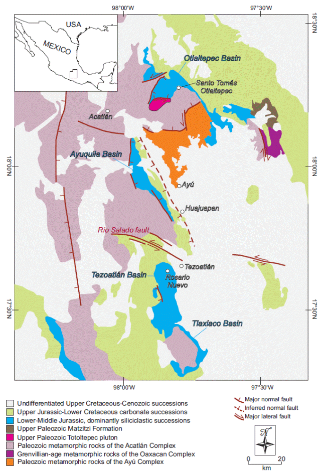
Figure 1 Geologic map of the southern Puebla and northern Oaxaca states, southern Mexico, showing the location and tectonic boundaries of major metamorphic and plutonic basement complexes, as well as the distribution of the Jurassic sedimentary successions (modified from Martini et al., 2016).
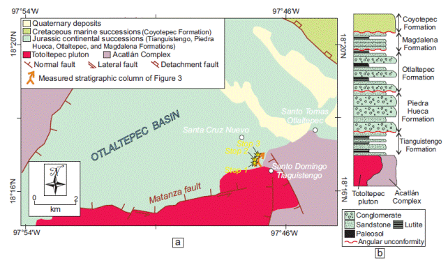
Figure 2 (a) Schematic geologic map of the Otlaltepec Basin, showing the distribution of the Jurassic continental succession and its contact relationship with basement rocks of the Acatlán Complex and Totoltepec pluton (modified from Martini et al., 2016). The location of the three main outcrops (yellow stars) that will be visited during the first day of the trip is reported in the map. (b) Schematic litostratigraphic column representative of the southern part of the Otlaltepec Basin. The column is according to Morán Zenteno et al. (1993) and Verde-Ramírez (2016).
2. The Otlaltepec Basin
The Otlaltepec Basin is exposed in the surroundings of Santo Tomás Otlaltepec (figures 1 and 2a) and is composed of a more than 2000 m thick clastic sedimentary succession. To the south-west, the clastic succession is faulted against the upper Paleozoic Totoltepec pluton (Kirsch et al., 2012) along the W-trending, sinistral normal Matanza fault (Figure 2a). The western boundary of the Otlaltepec Basin is represented by a NNE-trending normal fault along which the clastic succession is juxtaposed to Paleozoic metasedimentary rocks of the Acatlán Complex (Figure 2a; Ortega-Gutiérrez, 1978). The northern and eastern boundaries of the basin are not exposed. The comprehensive stratigraphic framework and internal architecture of the entire basin is poorly known because at present only its southern part has been exhaustively explored and studied. Along its southern part, the stratigraphic record of the Otlaltepec Basin has been subdivided into four units that, from the base to the top, are: the Tianguistengo, Piedra Hueca, Otlaltepec, and Magdalena Formations (Figure 2b; Ortega-Guerrero, 1989; Morán-Zenteno et al., 1993; Verde-Ramírez, 2016). These units are separated by regional-scale angular unconformities and are composed of fluvial to littoral deposits, some of which contain Jurassic flora (Ramos-Leal, 1989; Morán-Zenteno et al., 1993). This clastic succession is overlain by Lower Cretaceous shallow-marine limestones of the Coyotepec Formation, which were deposited during a regional-scale transgression event (Figure 2b; Morán-Zenteno et al., 1993).
During this field trip we will focus on the Piedra Hueca and Otlaltepec Formations. These units represent more than 80 % in volume of the Otlaltepec Basin and display a significant change in sandstone composition that has been interpreted as a manifestation of the complex history of extension and exhumation of lithospheric blocks during Pangea breakup (Martini et al., 2016).
2.1. PIEDRA HUECA FORMATION
The Piedra Hueca Formation dominantly consists of superposed, meterto decameter-thick, fining-upward fluvial successions that are composed from the base to the top of lithofacies Gt, Gp, St, and Sp (Table 1; Miall, 2006), eventually grading upward into lithofacies Sr and Fl (Figure 3; Martini et al., 2016). The superposition of these fining-upward successions records cyclical variations in the energy of the fluvial drainage. Gt and Gp lithofacies are interpreted as gravel bars deposited during high-water stages, and consist of scoopshape conglomeratic bodies. Both lithofacies cut laterally and vertically into each other (Figure 4a), reflecting a depositional setting dominated by unstable and laterally migrating channels (Martini et al., 2016). The overlaying St, Sp (Figure 4b), and Sr lithofacies are interpreted as the record of progressive decrease in energy of the fluvial flow, culminating with the deposition of suspended load represented by lithofacies Fl (Martini et al., 2016). Locally, matrixto clast-supported, poorly-sorted, inversely-graded conglomerates of lithofacies Gci (Figure 4c) are interbedded with cross-bedded conglomerates. A sharp non-erosional base is typical of these massive conglomerates, suggesting that they were formed by high-strength debris flows (e.g. Miall, 2006). Additionally, centimeterto decimeter-thick beds composed of tabular-shaped, laterally continuous sandstones with upper-plane lamination (lithofacies Sh; Figure 4d) are locally alternated with cross-bedded lithofacies and are interpreted as flash-flood-deposits (e.g. Miall, 2006). Based on the analogy with present-day sedimentary environments, the Piedra Hueca Formation has been interpreted as a proximal to intermediate alluvial fan or braided fluvial system (Martini et al., 2016).
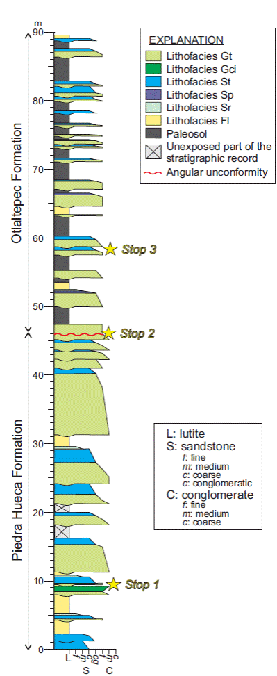
Figure 3 Representative stratigraphic column of the Piedra Hueca and Otlaltepec Formations exposed along the Magdalena Creek (modified from Martini et al., 2016). For a detailed description of the different lithofacies that compose the column see Table 1.
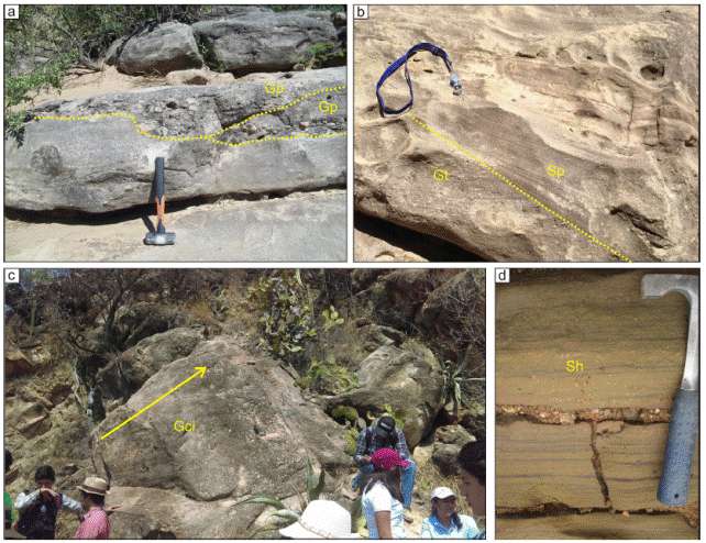
Figure 4 Photographs showing details of conglomerate and sandstone deposits that compose the Piedra Hueca Formation: (a) scoopshaped conglomerates of the Gp lithofacies; (b) coarseand medium-grained sandstone deposits of lithofacies Sp, displaying planar cross bedding; (c) inversely-graded, poorly-sorted conglomerate interpreted as lithofacies Gci; (d) tabular-shaped, coarse-grained sandstone deposits representative of lithofacies Sh, which shows upper-regime plane lamination.
Sandstones from the Piedra Hueca Formation vary in composition from feldspatho-quartzose to quartzo-feldspathic (Figure 5). The integration of detailed sandstone petrography, U-Pb detrital zircon geochronology, and detrital garnet chemistry suggests that Mesoproterozoic-Neoproterozoic, granulite-facies metamorphic rocks of the Oaxacan Complex (Figure 1) were the main source of detritus for the Piedra Hueca Formation (Martini et al., 2016). Subordinate detrital contributions from Paleozoic metasedimentary rocks of the Acatlán Complex, upper Paleozoic granitoids of the Totoltepec pluton, and Lower Jurassic syn-rift volcanic rocks that were locally emplaced in eastern Mexico during Pangea breakup are also documented (Martini et al., 2016).
Fossils in the Piedra Hueca Formation are scarce. Morán-Zenteno et al. (1993) reported poorly preserved cycad leaves such as Otozamites ssp., which is ubiquitous in Lower and Middle Jurassic fluvial deposits of Mexico (Perrilliat and Castañeda-Posadas, 2013).
2.2. OTLALTEPEC FORMATION
The Otlaltepec Formation overlies in angular unconformity the Piedra Hueca Formation (Figure 6). The Otlaltepec Formation is composed of rhythmically alternating conglomerate to finegrained sandstone deposits emplaced by traction currents (lithofacies Gt, St, Sp, Sr in Table 1), finely laminated lutite (Fl), and paleosols developed during prolonged periods of non-deposition in a subaerial environment (Figure 3; Martini et al., 2016). Based on these lithofacies assemblage, the Otlaltepec Formation has been interpreted as an overbank environment that was intermittently flooded during high-water stages and with subaerial exposition during low-water periods, favoring pedogenesis and the development of paleosols (Martini et al., 2016).
Sandstones from the Otlaltepec Formation vary in composition from feldspatho-quartzose to quartzoarenites (Figure 5; Martini et al., 2016). Petrographic data integrated with U-Pb detrital zircon geochronology and detrital garnet chemistry suggest that the Otlaltepec Formation was mostly derived from Mesoproterozoic-Neoproterozoic metamorphic rocks of the Oaxacan Complex as well as upper Paleozoic granitoids of the Totoltepec pluton (Figure 1; Martini et al., 2016). Subordinate detrital contributions from Paleozoic metasedimentary rocks of the Acatlán Complex and Jurassic syn-rift volcanic rocks emplaced in eastern Mexico during Pangea breakup were also documented (Martini et al., 2016).
Table 1 Synthesis of the lithofacies (Miall, 2006) that compose the stratigraphic column representative of the Piedra Hueca and Otlaltepec Formations
| Lithofacies code | Description | Interpretation |
|---|---|---|
| Gt | Scoop-shaped bodies of trough-cross-bedded conglomerate typically cut into each other both laterally and vertically. | Channel fill associated to low-sinuosity, braided drainages. |
| Gci | Clast to matrix-supported, poorly-sorted, conglomerate showing inverse grading. Beds of this lithofacies have sharp but non-erosional relationship with underlying deposits. | High-strength, plastic debris-flow-deposit. |
| St | Fine- to very coarse-grained sandstone displaying trough cross-bedding. | Sinous crested and linguoid (3D) dune. |
| Sp | Fine- to coarse. Grained sandstone displaying planar cross-bedding. | Transverse and linguoid (2D) dune. |
| Sr | Very fine- to coarse-grained sandstone displaying ripple cross-lamination. | Ripples (lower flow regime). |
| Fl | Horizontally interlaminated mudstone, siltstone, and very fine-grained sandstone. | Deposit formed under lower plane bed regime. |
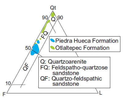
Figure 5 QtFL (Garzanti, 2016) diagram showing the sandstones composition of the Piedra Hueca and Otlaltepec Formation (modified from Martini et al., 2016).
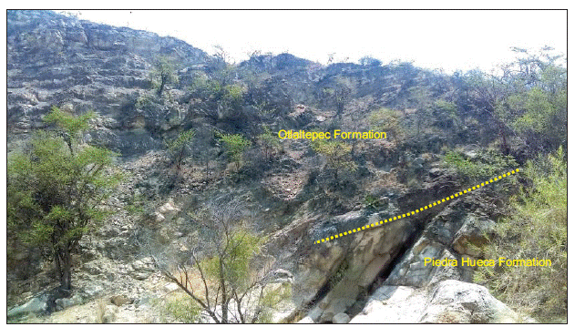
Figure 6 Exposure of the angular unconformity that participants will observe between the Piedra Hueca and Otlaltepec Formations.
In contrast to the Piedra Hueca Formation in which fossils are scarce and poorly preserved, sedimentary rocks of the Otlaltepec Formation contain abundant fossil leaves of Bennettitales, trunk molds, and minor amounts of fern and cycads leaves (Cruz-Cruz, 2012).
2.3. TECTONIC IMPLICATIONS
Because of its paleogeographic position along the nascent plate boundary between North and South America, Mexico represents a key area for reconstructing Pangea breakup. However, in the last decades, the progressive fragmentation of Pangea has been reconstructed in Mexico mostly on the basis of regional-scale geometrical considerations and geophysical data, most of which are the property of oil companies (e.g.Pindell, 1985; Ross and Scotese, 1988; Pindell and Kennan, 2009). To date, only few authors have been able to document major displacements along Jurassic faults in Mexico (e.g. Alaniz-Alvarez et al., 1996; Martiny et al., 2012). This is mostly due to the overprinting of Late Cretaceous and Paleocene tectonic events produced multiple episodes of fault reactivation that, in most cases, obliterated any evidence of major displacements during Jurassic time. The stratigraphic record exposed in the Otlaltepec Basin offers a great example of how Jurassic faults that participated to Pangea breakup can be indirectly recognized using a detailed provenance analysis of clastic rocks. In fact, according to Martini et al. (2016), the change in sandstone provenance documented in the Jurassic succession of the Otlaltepec Basin is a manifestation of the progressive continental attenuation and exhumation of different crustal blocks. More in detail, the sudden enrichment in detritus coming from the Totoltepec pluton in the Otlaltepec Formation has been interpreted as the result of rapid exhumation of this intrusive body along the Matanza fault, which is a W-trending, sinistral normal structure that bounds the Otlaltepec Basin to the south (figure 1 and 2). According to this interpretation, the Pangea breakup in southern Mexico is expressed by major sinistral block motions along W-trending faults. This is in agreement with regional-scale plate tectonic reconstructions, which predict that southern Mexico was located to the north-west of its present-day position by the beginning of Mesozoic time in order to avoid the overlap between North and South America in the reconstruction of Pangea (e.g. Pindell and Kennan, 2009).
2.4. PALEOCLIMATIC IMPLICATIONS
As noted by Martini et al. (2016), the provenance change documented in the stratigraphic record of the Otlaltepec Basin can be interpreted as the result of exhumation and subsequent erosion of different crustal blocks composed of different lithological assemblages. However, this process alone cannot explain the dramatic enrichment in quartz (up to 98 %) in most sandstone samples from the Otlaltepec Formation (Figure 5). In fact, although they were derived from different combinations of metamorphic and plutonic assemblages, both the Piedra Hueca and Otlaltepec Formations were sourced by rocks that display a quartzo-feldspathic composition. In lights of this consideration, the strong quartz enrichment in sandstones from the Otlaltepec Formation can be explained only assuming feldspar dilution by chemical weathering under humid climatic conditions (e.g. Basu, 1985; van der Kamp, 2010). Adopting the tectono-stratigraphic reconstruction proposed by Martini et al. (2016), the increase in quartz content coincides with the exhumation of the Totoltepec pluton.
Therefore, we suggest the possibility that the tectonic exhumation and uplift of the Totoltepec pluton could have favored the progressive landscape fragmentation, producing local climatic variations that controlled the composition of sediments. At present, this hypothesis has not been exhaustively explored and, therefore, the stratigraphic record of the Otlaltepec Basin offers some perspective for future studies focused on the reconstruction of climatic conditions under which the Jurassic successions were deposited.
3. The Tezoatlán Basin
The Tezoatlán Basin is located in the vicinity of the homonymous town, south of Huajuapan de León in the state of Oaxaca (Figures 1 and 7a). The northern boundary of the Tezoatlán Basin is represented by the WNW-trending Río Salado fault (Figure 1), which is a kilometer-scale, multi-reactivated structure that produced major sinistral normal displacements during Jurassic time (Martiny et al., 2012). The eastern and western boundaries are buried under Cenozoic volcanic rocks, whereas the southern limit with the coeval Tlaxiaco Basin (Figure 1) has not been studied in detail. As for the Otlaltepec Basin, the Tezoatlán Basin is composed of an approximately 1000 m thick continental clastic succession that contains abundant Jurassic fossil flora (Erben, 1956; Morán-Zenteno et al., 1993). This clastic succession conformably overlies Lower Jurassic, mafic to felsitic volcanic rocks of the Diquiyú Formation (Figure 7b; Durán-Aguilar, 2013), which have been interpreted as a manifestation of the syn-rift magmatism that accompanied the breakup of Pangea (Martini and Ortega-Gutiérrez, 2016). Differing from the Otlaltepec Basin, in which the oldest marine deposits are Early Cretaceous in age, the continental succession in the Tezoatlán Basin is overlain by marine rocks that contain a Bajocian-Bathonian fossil fauna (Erben, 1956; Sandoval and Westermann, 1986; Cantú-Chapa, 1998). In light of these data, some authors proposed that Mexico was progressively transgressed from south to north by Pacific marine waters during Mesozoic time (Cantú-Chapa, 1998). However, this scenario contrasts with the most widely accepted idea of a transgression driven by sea-floor spreading in the Gulf of Mexico and Atlantic Ocean, as it is suggested by the affinity of several Jurassic ammonites with faunal assemblages of the Tethys (e.g. Sandoval and Westernmann, 1986; Olóriz et al., 2000; Olóriz et al., 2003). The Jurassic clastic succession exposed in the Tezoatlán Basin has been subdivided into three stratigraphic units that, from the base to the top, are: the Rosario and Cualac Formation and the Tecocoyunca Group (Figure 7b; Erben, 1956).
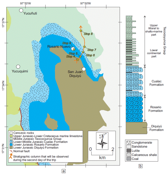
Figure 7 (a) Schematic geologic map of the Tezoatlán Basin, showing the distribution of the Jurassic (modified from Morán-Zenteno et al., 1993). The location of the main outcrops (yellow stars) that will be visited during the second day of the trip is reported in the map. (b) Schematic lithostratigraphic column representative of the Tezoatlán Basin. The column is according to Erben (1956) and Morán-Zenteno et al. (1993).
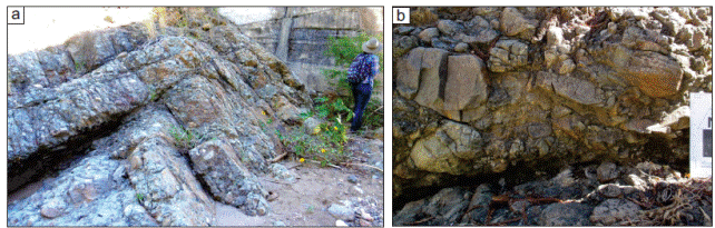
Figure 8 Photographs showing details of conglomeratic deposits of the Rosario Formation: (a) clastto matrix-supported, poorlysorted conglomerate showing crude bedding; (b) imbricated volcanic clasts in a conglomeratic deposit.
During this field trip, participants will have the opportunity to observe different sedimentological and paleontological aspects of the three clastic units exposed in the Tezoatlán Basin. We will discuss the tectonic setting and climatic conditions under which the sedimentary succession was deposited and compare the tectono-stratigraphic and paleoenvironmental evolution of the Tezoatlán and Otlaltepec Basins.
3.1. ROSARIO FORMATION
The Rosario Formation is dominantly composed of conglomerate and minor sandstone lenses, lutite, and coal (Erben, 1956; Morán-Zenteno et al., 1993; Durán-Aguilar 2013). Conglomerate deposits are dominantly matrix-supported, poorly-sorted, and locally display crude stratification, imbrication, and inverse grading (Figure 8a; Durán-Aguilar, 2013). Based on these characteristics, diverse authors interpreted the Rosario Formation as the stratigraphic record of a high-energy fluvial stream and its associated flood plain environment (Morán-Zenteno et al., 1993; Durán-Aguilar, 2013). Conglomerate and sandstone deposits of the Rosario Formation are mostly composed of volcanic clasts (Figure 8b) that have been interpreted to be derived from the underlying Diquiyú Formation (Morán-Zenteno et al., 1993). However, a detailed provenance study of the Rosario Formation has not been carried out. Because of its fossil flora, the Rosario Formation has been object of several studies by different authors during the last decades. More in detail, previous authors documented in the Rosario Formation a new species of male and female reproductive organs of Bennettitales (Williamsoniaceae), as well as the new genus MexiglossaDelevoryas et Person Delevoryas, 1966, 1968, 1969; Delevoryas and Person, 1975; Person, 1976. Genus Mexiglossa suggests an affinity with Gondwana, whereas the reproductive organs of Williamsoniaceae are similar to those reported in Yorkshire in the United Kingdom and Rajmahall Hills in India. In addition, Ortega and Velasco-de León (2015) collected an 8 m-long fossil trunk that has been determined as Agathoxylon Harting. Moreover, the finding of the Nehvizdyella Kvaček, Falcon-Lang et Dasková includes the Tezoatlán area in the distribution of the Ginkgoales order (Lozano-Carmona and Velasco-de León, 2016). Representative samples of the floral content recovered from the Rosario Formation will be observed at the Geological Museum of Rosario Nuevo during the second day of the field trip.
3.2. CUALAC FORMATION
The Cualac Formation overlies the Rosario Formation in a transitional contact. The Cualac Formation is dominantly composed of conglomerate and conglomeratic sandstone interbedded with minor coarseto fine-grained sandstones and lutite (Figure 9a; Erben, 1956; Morán-Zenteno et al., 1993; Durán-Aguilar, 2013). A detailed sedimentological study of this unit has not been carried out. Some authors interpreted the Cualac Formation as the proximal part of alluvial fans developed in a high relief region (Morán-Zenteno et al., 1993), whereas other authors suggested that this unit represents the stratigraphic record of a meandering river (Durán-Aguilar, 2013). Exposures observed during the field trip will permit an exhaustive discussion on these two competing interpretations. Differing from the underlying Rosario Formation, which is mostly composed of volcanic clasts, the Cualac Formation is dominantly made up of fragments of quartz and quartz-rich metamorphic rocks (Figure 9b; Morán-Zenteno et al., 1993; Durán-Aguilar, 2013). To date, an exhaustive provenance analysis of these clastic rocks has not been published.
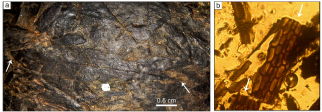
Fossil flora in the Cualac Formation exposed in the Tezoatlán Basin consists of Mexiglossa varia (Figure 10a), as well as Zamites oaxacenis, Z. diquiyui, Anomozamites, Otozamites hespera, Ptillophyllum sp. and Williamsoniaceae flowers (Guzmán and Velasco-de León, 2014). A detailed cuticle analysis shows that epidermal cells of Mexiglossa varia recovered from the Tezoatlán area are rectangular in shape, display slightly wavy walls, sunken stomas, and are arranged in rows with apparent disorder (Figure 10b). These characteristics permit to differentiate this genus from Glossopteris Brongniart.
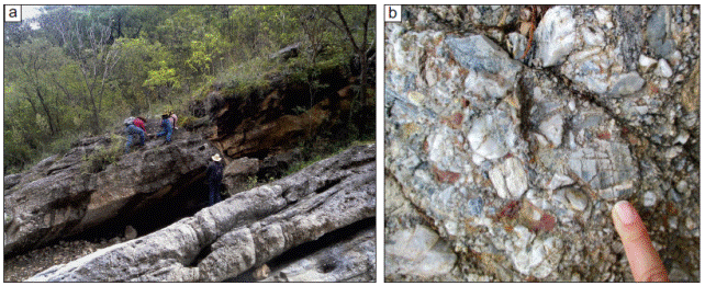
Figure 9 hotographs showing details of conglomerate, sandstone, and lutite that compose the Cualac Formation: (a) superposed meter-thick successions showing a typical fining-upward trend; (b) clast-supported, poorly-sorted conglomerate composed of subangular clasts derived from quartz-rich metamorphic rocks.
3.3. TECOCOYUNCA GROUP
The Tecocoyunca Group overlies the Cualac Formation in a transitional contact. According to Erben 1956, the Tecocoyunca Group can be subdivided into five different formations that are: the Zorrillo, Taberna, Simon, Otatera, and Yucuñuti Formations. However, as pointed out by Morán-Zenteno et al. 1993, the lithological and sedimentological differences between these formations are often subtle and, therefore, the recognition of these units on the field is not easy and may be subjective. In general terms, the lower stratigraphic part of the Tecocoyunca Group is dominantly composed of sandstone, black shale, and coal containing abundant fossil flora (Figure 11; Morán-Zenteno et al., 1993). On the other hand, the upper stratigraphic part is composed of sandstone and shale with marine mollusks and ammonites of Bajocian and Bathonian age such as Duashnoceras Westermann, Leptosphinctes Buckman, and Parastrenoceras Ochoterena (Erben, 1956; Sandoval and Westermann, 1986; Cantú-Chapa, 1998). Based on the sedimentological and paleontological characteristics, the succession of the Tecocoyunca Group has been interpreted as a flood-plain environment with marsh areas that progressively evolved into a littoral to shallow-water marine environment connected to an open sea (Morán-Zenteno et al., 1993).
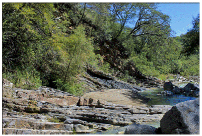
Figure 11 Exposure of continental sandstone and lutite that compose the lower stratigraphic part of the Tecocoyunca Group.
As for the Cualac Formation, sandstones of the Tecocoyunca Group are mainly composed of quartz and quartz-rich metamorphic fragments (Durán-Aguilar, 2013). However, a detailed provenance analysis of these sandstones is presently not available.
The abundant fossil flora contained in the Tecocoyunca Group has been object of study by several authors. Wieland (1914), Delevoryas 1971, and Silva-Pineda 1984 originally documented various specimens of Bennettitales, Cycadales, Filicales, and Equisetales. Subsequently, new findings from various authors pointed out the presence of Ginkgoales, Caytoniales, Czekanowskiales, Podozamitales, and Filicales in the lower stratigraphic part of the Tecocoyunca Group (Rojas-Chávez, 2010; Lozano-Carmona, 2012; Lozano-Carmona and Velasco-de León 2014; Velasco-de León et al., 2013, 2014).
3.4. TECTONIC IMPLICATIONS
As it has been documented in the Otlaltepec Basin, the Jurassic clastic succession exposed in the Tezoatlán Basin records a major compositional change. Whereas conglomerate and sandstone of the Rosario Formation are mostly composed of volcanic clasts apparently sourced by the underlying Diquiyú Formation, clastic deposits of the Cualac Formation and Tecocoyunca Group dominantly consists of quartz and quartz-rich metamorphic fragments derived from a crystalline basement (Morán-Zenteno et al., 1993; Durán-Aguilar, 2013). As it has been suggested for the Otlaltepec Basin, the compositional change in the succession exposed in the Tezoatlán Basin could be the result of the exhumation of different basement blocks during the fragmentation of Pangea. Unfortunately, a detailed provenance analysis for these units is not available. Therefore, recognizing the major faults that controlled the exhumation of basement blocks and the consequent change in composition in the clastic succession of the Tezoatlán Basin is not presently possible. The Río Salado fault is a major NNW-trending Jurassic structure along which the Tezoatlán Basin is directly juxtaposed to Paleozoic quartz-rich metasedimentary rocks of the Acatlán Complex (Figure 1; Martiny et al., 2012). On the field, we will take the occasion to discuss the possibility that the progressive enrichment in quartz and quartz-rich metamorphic fragments in the Cualac Formation and Tecocoyunca Group could be produced by the exhumation of metasedimentary rocks of the Acatlán Complex along the Río Salado fault.
3.5. PALEOCLIMATIC IMPLICATIONS
The foliar area analysis conducted on various specimens of gymnosperms extracted from the Rosario Formation suggests that this unit was deposited under a seasonal climate characterized by alternating periods of high temperature associated with severe droughts and periods of high rainfall (Velasco-de León et al., 2013). On the other hand, the presence of Ceratozamia and Mexiglossa varia in the Cualac Formation indicate that this unit was deposited under climatic conditions characterized by lower temperature and higher humidity (Velasco-de León et al., 2013). Based on these considerations, a major change in climatic conditions can be documented in the Tezoatlán area during Jurassic time. As in the Otlaltepec Basin, such a climatic change seems to coincide with a major provenance change in the sedimentary succession.
4. Conclusions
The integration of sandstone petrologic and paleontologic data suggests that deposition of Jurassic clastic successions in the Otlaltepec and Tezoatlán Basins was accompanied by major changes in climatic conditions. More in detail, an evolution from dry or seasonal to humid conditions is supported by sandstone whole-rock composition and fossil flora. Interestingly, these climatic variations coincide with major changes in provenance of clastic rocks. Provenance changes in the Otlaltepec and Tezoatlán successions are interpreted as the manifestation of the complex history of exhumation of different fault-bounded lithospheric blocks that accompanied Pangea breakup. Based on these considerations, we preliminarily suggest that the progressive fragmentation of Pangea produced a major topographic reorganization that favored local variations in climatic conditions and the diversification of floral assemblages in Mexico during Jurassic time.
5. Field trip
5.1. DAY ONE
During the first day of the trip participants will observe representative exposures of the Otlaltepec Basin along the Magdalena Canyon (Figure 3). This canyon offers the possibility of examining in detail the sedimentological and petrological characteristics of the Piedra Hueca and Otlaltepec Formations, as well as their fossil flora.
5.1.1. STOP 1: PIEDRA HUECA FORMATION (18°16’59.92”N, 97°48’9.77”W)
At this outcrop we will observe conglomerate, sandstone, and lutite representative of the Piedra Hueca Formation. Conglomerate deposits are dominantly troughto planar-cross-bedded (lithofacies Gt and Gp) and grade upward into conglomeraticto fine-grained sandstone that show troughto planar-cross-bedding (lithofacies St, Sp). Locally, drapes of horizontally laminated, very fine-grained sandstone and lutite (lithofacies Fl) overlie sandstone deposits. This lithofacies assemblage is interpreted to reflect the seasonal decrease in energy of a braided fluvial system. Locally, deci
meter-thick deposits composed of tabular-shaped, laterally continuous sandstones with upper-plane lamination are alternated with cross-bedded lithofacies, and they are interpreted to be emplaced during flash-flood events. Conglomerate and sandstone deposits are dominantly composed of quartzo-feldspathic clasts derived from granulite-facies rocks of the Oaxacan Complex. Greenschist-facies metamorphic clasts sourced by the Acatlán Complex are also present. Detailed petrographic and geochronologic data will be presented at the outcrop in order to stimulate the discussion on the provenance of this stratigraphic unit.
5.1.2. STOP 2: ANGULAR UNCONFORMITY BETWEEN THE PIEDRA HUECA AND OTLALTEPEC FORMATIONS (18°17’0.35”N, 97°48’9.73”W)
The goal of this stop is to observe an excellent exposure of the stratigraphic relationship between the Piedra Hueca and Otlaltepec Formations. As we will observe on the field, the contact between these two units is an angular unconformity where ~50°-dipping beds of the Piedra Hueca Formation are overlain by ~20°-dipping strata of the Otlaltepec Formation. The aforementioned unconformity is interpreted as the result of exhumation of the Totoltepec pluton along the normal sinistral Matanza fault. Such interpretation is supported by the enrichment in clasts derived from the Totoltepec pluton in the Otlaltepec Formations. Evidence of syn-sedimentary faulting in the Otlaltepec Basin area is given by the widespread occurrence of centimeterto meter-scale, syn-sedimentary normal faults throughout the entire succession. Some of these faults will be observed and discussed at this outcrop.
5.1.3. STOP 3: OTLALTEPEC FORMATION (18°17’2.90”N, 97°48’12.49”W)
At this stop, participants will observe a representative succession of the Otlaltepec Formation, which is composed of rhythmically alternating conglomerate to fine sandstone deposits emplaced by traction currents (lithofacies Gt, St, Sp, Sr in Table 1), finely laminated lutite (lithofacies Fl) with abundant cycad and fern leaves, and paleosols developed during prolonged periods of non-deposition in a subaerial environment. Conglomerate and sandstone deposits are dominantly sourced by quartzo-feldspathic rocks of the Totoltepec pluton and Oaxacan Complex. Detailed petrographic and U-Pb geochronologic data on detrital zircons will be presented at this outcrop in order to discuss the provenance of the Otlaltepec Formation. Despite the quartzo-feldespathic composition of source rocks, the Otlaltepec Formation displays a high enrichment in quartz (up to 98% of the total framework grains). This strong enrichment in quartz is explained here assuming that feldspar dilution was produced by chemical weathering under humid climatic conditions (e.g. Basu, 1985; van der Kamp, 2010).
5.2. DAY TWO
During the second day of the trip, participants will observe representative exposures of the Tezoatlán Basin along the Rosario Nuevo Canyon (Figure 11). This canyon offers the opportunity of examining in detail the sedimentologic and petrologic characteristics of the stratigraphic units that compose the Tezoatlán Basin, as well its fossil flora content.
5.2.1. STOP 4: DIQUIYÚ FORMATION (17°36’6.78”N, 97°50’56.97”W)
At this stop, we will observe andesitic volcanic rocks of the Diquiyú Formation that represents the basement of the Tezoatlán clastic succession. The Diquiyú Formation is interpreted as the source for the overlying Rosario Formation (Morán-Zenteno et al., 1993). Therefore, the aim of this stop is to observe textural and compositional details of the Diquiyú Formation in order to compare these volcanic rocks with volcanic clasts of the Rosario Formation.
5.2.2. STOP 5: ROSARIO FORMATION (17°36’9.35”N, 97°50’54.39”W)
At this stop, participants will observe an excellent exposure of the Rosario Formation. This unit is mostly composed of clastto matrix-supported, poorly-sorted, and crudely-bedded conglomerate deposits that have been interpreted by previous authors as the stratigraphic record of a high-energy fluvial stream (Morán-Zenteno et al., 1993). Clasts in the Rosario Formation are mostly composed of volcanic rocks that show textural and compositional similarities with the Diquiyú Formation.
5.2.3. STOP 6: CUALAC FORMATION (17°36’18.2”N, 97°50’40.9”W)
At this outcrop, we will observe representative exposures of the Cualac Formation. At this point, the Cualac Formation is composed of conglomerate, coarseto fine-grained sandstone, and shale that display a variety of sedimentary structures such as through to planar cross bedding, imbrication, and ripple marks. After a careful observation of the sedimentological characteristics of the Cualac Formation, we will evaluate the possibility that this unit was deposited in a proximal alluvial fan environment as it was suggested by Morán-Zenteno et al. (1993) or in a meandering river as it was proposed by Durán-Aguilar (2013). Furthermore, participants will observe that clastic deposits of the Cualac Formation display a dramatic change in composition relative to the Rosario Formation. In fact, the Cualac Formation is dominantly composed of quartz and quartz-rich metamorphic fragments. We will discuss on the field the significance of such a compositional change in the clastic stratigraphic record.
At this outcrop, finely laminated shale layers preserve impressions of leaves that have been determined as Mexiglossa varia, Zamites, Otozamites, and Anomozamites.
5.2.4. STOP 7: LOWER TECOCOYUNCA GROUP (17°36’22”N, 97°50’38.8”W)
The goal of this stop is to observe excellent exposures of the lower stratigraphic part of the Tecocoyunca Group, which is composed here of a succession of sandstone, shale, and coal that has been interpreted as the stratigraphic record of a flood-plain environment (Morán-Zenteno et al., 1993). Shale of this outcrop preserves leaves impressions that will be described on the field in order to discuss the climatic conditions under which this unit was deposited.
5.2.5. STOP 8: UPPER TECOCOYUNCA GROUP, (17°36’29.6”N, 97°50’38.7”W)
At this outcrop, participant will observe the transition from the lower to the upper parts of the Tecocoyunca Group. This transition in marked by a gradual change from continental to littoral and shallow-marine sedimentary environment that was the result of a regional marine transgression in the Tezoatlán area. Shallow marine deposits are composed of rhythmically interbedded sandstone and calcareous shale that contain Bajocian and Bathonian fossils of bivalves and ammonites such as Oppelia, Leptosphinctes, Parastrenocera, Trigonia, Myophorella, and Vaugonhia.
5.2.6. STOP 9: GEOLOGICAL MUSEUM OF ROSARIO NUEVO (17°36’11.56”N, 97°51’13.7”W)
We will take the occasion to visit the regional museum of Rosario Nuevo, where representative fossils from the continental to marine succession of the Tezoatlán Basin are exposed.
5.2.7. STOP 10: CERRO DE LAS MINAS ARCHEOLOGICAL SITE
If time permits, we will take the opportunity to visit the archeological site “Cerro de las Minas” that is located northward of Huajuapan de León (Figure 2). This site belongs to the Ñuiñe culture, and it was founded during the Preclassic period and reached its climax throughout the early Classic period between 400 and 800 CE. In the course of this period, other major cities flourished such as Monte Alban in the state of Oaxaca and Teotihuacan in the Valley of Mexico. Cerro de las Minas is located in a hill that dominates the valley of Huajuapan de León. This large hill was in a strategic position over the farmlands of the valley, permitting the absolute control on the trade routes that crossed this region. The site contains a number of settlements and was reserved for the elite of the area during that time. Cerro de las Minas is the only archeological site of the Mixteca Baja region open to the public.

