


 text new page (beta)
 English (pdf)
 Article in xml format
 Article references
 Send this article by e-mail
 Cited by SciELO
  Similars in
SciELO
Similars in
SciELO 
 Permalink
1. Introduction
The region of Zimapán (Figure 1), in central Mexico, was the focus of much geologic interest during the early 19th century because of its metal mining operations. As a result, some of the earliest published geological observations made in Mexico are of this region (del Río, 1803; Sonneschmid, 1804; von Humboldt, 1811), and somewhat later ones already include geologic maps and cross sections (von Gerolt and de Berghes, 1827; Burkart, 1836; Galeotti, 1838a, 1838b). Here, I review the content of these legacy publications, provide facsimiles of some of their key figures, and place these pioneering studies in a historical context.
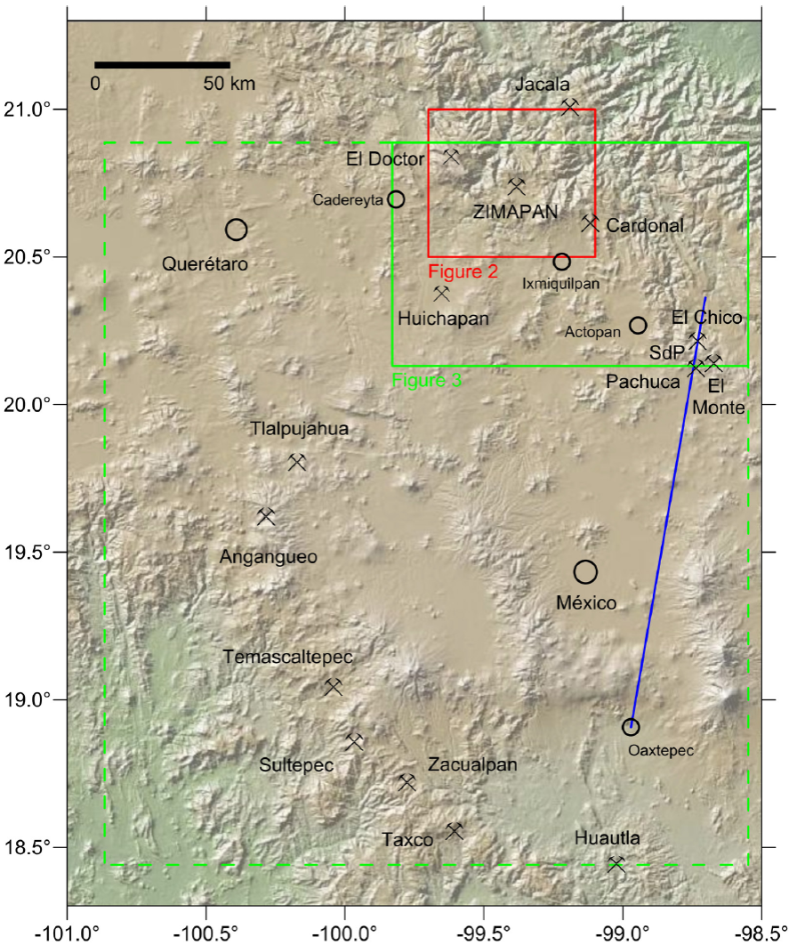
Figure 1 Shaded relief map of central Mexico, indicating the location of Zimapán and the approximate extent of the geologic map by von Gerolt and de Berghes (1827) (green dashed outline). Also indicated are the regions covered by Figure 2 (green solid outline) and Figure 3 (red outline). Also marked are major mining districts of the early 19th century and, in blue, the trace of the geologic section by von Humboldt (1834), constructed in 1803. SdP: Sierra de Pachuca.
2. Early Colonial Mining
Silver has been mined in the Zimapán region since ~A.D. 1575 according to the Relación de las Minas de Cimapan (Acuña, 1985). This report, written in A.D. 1579 and preserved in the Archivo General de Indias in Seville, Spain (Gerhard, 1986), provides the response by the colonial government to a geographic questionnaire commissioned by the Spanish crown. Based on this Relación Geográfica, Zimapán was settled in A.D. 1575 by Spanish miners. Beside silver, the mines produced much margajita (marcasite, FeS2), caparrosa (copperas, FeSO4), and an overabundance of lead. The Relación de las Minas de Cimapanincludes a map (Acuña, 1985) that shows the toponyms "Minas del Monte", "Minas del Toliman", and "Minas de Santiago." Mines in the Sierra El Monte and in the Barranca de Tolimán (Figure 2), which are associated with monzonite intrusive bodies and dikes (Simons and Mapes, 1956), are still the principal metal production areas of the Zimapán mining district (Navarro-Barrera, 1982; García and Querol, 1991; Yta and Moreno-Tovar, 1997).
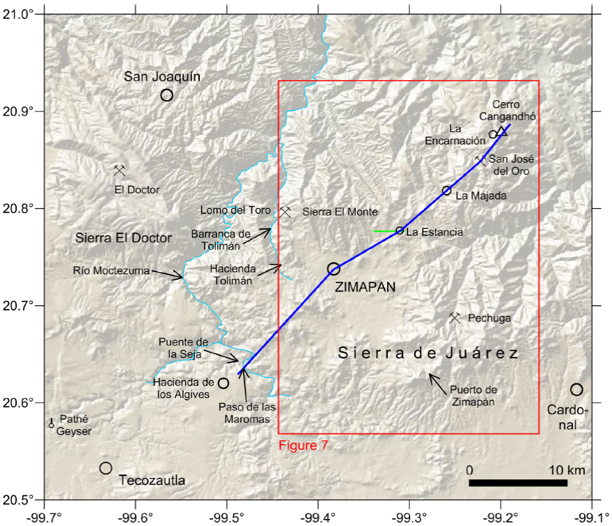
Figure 2 Outline map of the Zimapán area, indicating in blue the trace of the geologic section by Burkart (1836), reproduced in Figure 6. Red box: approximate extent of the geologic map by Galeotti (1838a), shown in Figure 7. Also indicated are several place names mentioned in the text.
Since the Zimapán ore contains admixtures of lead-bearing minerals, the separation of silver from the base metal was done by smelting in a furnace rather than by the more efficient amalgamation with mercury. Some of the lead compounds were shipped to other mining camps such as Guanajuato and Pachuca, where they were used in the smelting process, whereas by demand of the Spanish Crown all silver was sent to Mexico City (Figure 1) for coinage at the royal mint (Brading, 1971 and references therein).
3. Geologic Studies During the Colonial Period
The Real de Minas de Zimapán was visited in 1791 by the Comisión Científica Novohispana. This was a detached party by some members of the Malaspina expedition, a Spanish maritime naturalist journey. In the journal of his voyage, Alejandro Malaspina explicitly asked the Comisión Científica Novohispana, lead by naturalist Antonio Pineda y Ramírez, to focus its research on lithology (David et al., 2003). From late August 1791 on, this group of naturalists visited mining districts north of Mexico City, such as Pachuca and Guanajuato, for more than two months; a map of their itinerary can be found in González Claverán (1988, 1989). The expedition visited Zimapán in September of 1791, arriving from the lead mines at Real del Cardonal through Ixmiquilpan (Figure 1) and then moving on to Paso de las Maromas, Hacienda de los Algives and Santiago Tecozautla (Figure 2), from where they examined the nearby Pathé thermal baths (Engstrand, 1981; González Claverán, 1988). The travel diaries written by Antonio Pineda y Ramírez are conserved at the Archivo del Museo Naval, Madrid (manuscripts 562 and 563) and were partly transcribed by González Claverán (1988). Pineda notes that Ixmiquilpan is located in a scrubby terrain on limestone, and that he crossed near town gravel composed of limestone and porphyry pebbles with a red surface. He describes the ore smelting and refining process at Zimapán in detail and documents it with drawings. Pineda also visited the Santa Clara and San Vicente mines, located northwest of Zimapán, near the Barranca de Tolimán (Simons and Mapes, 1956), from where he reports that the dikes in the Santa Clara mine are oriented east-west and intruded in limestone and that the dikes at the portal of the San Vicente mine bifurcate.
More importantly, the Zimapán Mining district attracted, in the very early 19th century, scholars from the Real Seminario de Minería (Quelle, 1937; Pferdekamp, 1938; Trabulse, 1994; Azuela, 2005, 2009; Ramos Lara, 2012), such as Andrés Manuel del Río (Amorós Portolés, 1985; Rubinóvich, 1992; Puche Riart and Ayala Carcedo, 1993; Trabulse, 1984, 1994 and references therein), Friedrich (Federico) Traugott Sonneschmid (Liesegang, 1949; von Mentz, 1982; Trabulse, 1984; Strulik, 1988 and references therein), and Alexander von Humboldt, who was a visiting scholar at the Real Seminario de Minería in 1803 - 1804 (Beck, 1958, 1966; Beck and Bonacker, 1969; Rubinóvich and Lozano, 1997; Leitner, 2000). All three of them were graduates of the Freiberg mining academy (Bergakademie Freiberg) in Saxony (Quelle, 1937; Strulik, 1988) and much-influenced by the teaching of Abraham Gottlob Werner. In Werner's account of earth history, which dominated geology until the 1820s, rocks were successively deposited in a primordial ocean as universal formations that could be recognized around the whole globe on the basis of lithology and superposition (Laudan, 1987). This theory is echoed by del Río (1803) in his "Discurso sobre las formaciones de las montañas de algunos Reales de minas", when he writes
"...las montañas... están dispuestas y colocadas regularmente unas sobre otras, é estratificadas con mucho órden, y que la relacion de su estratificación, ó la sucesion de sus laxas y capas, lejos de estar circunscripta á cada punto de la superficie del globo, y ser diversa en cada parage, es al contrario idéntica, y se repite muchas veces en paises muy distantes unos de otros, y tan constantemente, que se puede determinar hasta su diversa antigüedad."
Based on the same concept, von Humboldt (1805) designs and correlates stratigraphic columns of the American and European continents in his Introducción a la pasigrafía geológica, which forms part of del Río's textbook "Elementos de Orictognosia" (del Río, 1805, 1985, 1992), and on which he eventually elaborates in his Geognostischer Versuch über die Lagerung der Gebirgsarten in beiden Erdhälften (Ensayo geognóstico sobre la superposición de las rocas en los dos hemisferios) (von Humboldt, 1823).
What we now would call the geological sciences had, at that time, three major divisions: orictognosy, the identification and classification of minerals; geognosy, the formation and history of rocks and minerals; and mineral geography, the distribution of rocks and minerals both above and below ground (Laudan, 1992).
A textual description of some outcrops near Zimapán (along Barranca de Tolimán, in the Sierra El Monte region, and in the mountain range between Zimapán and Ixmiquilpan; Figure 2) is given by del Río (1803), based on quoted field observations by Sonneschmid and samples from the Seminario de Minería rock collection. Del Río, who is better known for his discovery of the element vanadium (Caswell, 2003) and his chemical analyses of minerals (e.g., del Río, 1835a; 1835b; Trabulse, 1984, 1994, and references therein), describes sediments such as fossil-bearing limestone with chert intercalations, greywacke, slate, shale, and marl, occasionally indicating their strike and dip. His description also includes several types of igneous rocks and their mineral composition, as well as economic mineral deposits and their locations. However, his study is difficult to verify or compare with more recent observations, since it does not include maps or sections. Del Río (1803) also compares the lithologies of the Zimapán region with those at other nearby mining centers such as Real del Doctor, Xacala, Real del Oro, Pechuga, or Real del Cardonal (Figures 1 and 2).
A note in del Río (1803), for which he gives credit to von Humboldt, is
"El rumbo y el echado de las laxas y capas no sigue de ningun modo como se creía la direccion ni el declive de las cordilleras."
His observation was probably puzzling to von Humboldt because in Werner's theory, inclined strata were deposited on the continental slope of an inactive earth. His way of reasoning is, at the same time, an early use of the principle of falsificationism (Cleland, 2001).
A very similar but much more detailed account of the outcrops in the Zimapán region is given by Sonneschmid (1804), in his review of the minerals and rocks of the major mining districts in Mexico. This treatise was relied upon and credited in Alexander von Humboldt's work as well as that of Joseph Burkart (see below). However, contrary to von Humboldt's work, the book by Sonneschmid is virtually unknown (von Mentz, 1982); it has escaped attention in reviews of the history of geologic studies in Mexico (e.g., Aguilera, 1904; de Cserna, 1990). Sonneschmid stayed in Mexico for 12 years, where he was employed at the Real Seminario de Minería. He returned to Germany in 1800, before von Humboldt's visit. His report about the Zimapán region is based on 100 days of field work there, barometric readings, and assaying some of his samples with a blowpipe (for a discussion of this technique, see Newcomb, 2009). However, like del Río's 1803 account, the work by Sonneschmid (1804) is difficult to assess, not only because it is not supported by maps or sections, but also because of the geological complexity of that region (see maps in Simons and Mapes, 1956) and because of the now obsolete stratigraphic concept and names for rocks used by Sonneschmid. Del Río and Sonneschmid followed Werner's identification of the sequence of rocks, in which a "primitive class of rock formations" (predominantly granite and gneiss but also porphyry, slate, and sediments) is overlain by the "transition rocks" (mostly limestone and greywacke), followed in sequence by the "secondary class of rock formations" (such as sandstone, limestone, and gypsum) and alluvium (Laudan, 1987; Oldroyd, 2013).
The geology of the Zimapán region is also mentioned cursorily by von Humboldt (1811) in his Essai politique sur le royaume de la Nouvelle Espagne and in Geognostischer Versuch über die Lagerung der Gebirgsarten in beiden Erdhälften (Ensayo geognóstico sobre la superposición de las rocas en los dos hemisferios) (von Humboldt, 1823). Like del Río's (1803), Humboldt's work about the Zimapán region, which he did not visit, is based on Sonneschmid (1804).
4. Geologic Studies after Mexico's Gain of Independence from Spain
In order to stimulate the debilitated economy in the aftermath of the revolutionary war, several mining corporations relying on British, German, and American capital investment and technology were formed after Mexico's gain of independence in 1821 (Kruse, 1923; Strulik, 1988). As a result, the published geologic information about the mining regions increased and included, for the first time, geologic maps and cross sections (von Gerolt and de Berghes, 1827; Burkart, 1836). In the Zimapán region, most mines were leased by the German-American Mining Corporation (Deutsch-Amerikanischer Bergwerksverein, Sociedad Minera Alemana-Americana) (Kruse, 1923; Pferdekamp, 1958). An exception was the Lomo del Toro lead mine (Figure 2), which was leased by the British Real del Monte Company (Randall, 1972). Thomas Coulter, a renowned Irish botanist, was in charge of the mine up to 1829 (Coville, 1895; Nelson, 1988). Unrelated to the mining companies, the Belgian naturalist Henri Guillaume Galeotti also did geologic field work in the Zimapán region during this time. In what follows, I document, in chronological order, the maps and cross sections of the Zimapán region published during this period by von Gerolt and de Berghes (1827), Burkart (1836), and Galeotti (1838a, 1838b).
4.1. The Map and Sections by von Gerolt and de Berghes
The earliest geologic map and sections of central Mexico, including the Zimapán region, were published in 1827 by Friedrich Karl Joseph von Gerolt and Carlos de Berghes, who were employed by the German-Mexican Mining Corporation and, like the scholars of the Real Seminario de Minería, were graduates of the Bergakademie Freiberg in Saxony (Kruse, 1923; Liesegang, 1949; Pferdekamp, 1958). This is the earliest published geologic map of any region in Mexico and among the earliest known regional geologic maps in Mexico after the 1803 geologic-topographic map of the Guanajuato area by Alexander von Humboldt (published in 1834; facsimile in Beck and Bonacker, 1969) and the 1826 geologic map, with five lithologic units, of the San Francisco (Alta California) Bay area by Edward Belcher, published in 1839 (Beidleman, 2006; Norris and Webb, 1990). The map by von Gerolt and de Berghes (1827) is practically unknown today; like the 1803 map of the Guanajuato area by Alexander von Humboldt, it has mostly escaped attention in reviews of early geologic maps (e.g., Oldroyd, 2013).
With the meridian of Mexico City as its origin, the map extends from 1° E to 1.5° W longitude of Mexico City and from about 18.4° to 21° N latitude (Figure 1). It builds on the previous topographic maps of central Mexico by Alexander von Humboldt (1811) (Beck and Bonacker, 1969), which were locally based on a detailed unpublished map of the region between Real del Doctor and Zimapán by Manuel Mascaró.
The map covers the mining districts worked by the German-American Mining Corporation (Figure 1): El Chico in the east; San José del Oro and Zimapán in the north; Tlalpujahua and Angangueo in the west; and Temascaltepec and Sultepec in the southwest. In the south, the map reaches until the mining district of Huautla.
The map went through several editions. The original edition was published in German (von Gerolt and de Berghes, 1827). It included a topographic map sheet, a sheet with the geology overlain on the same base map, four sheets with profiles, and an explanatory pamphlet that mostly refers to ore deposits. Detailed contemporary reviews were provided by Nöggerath (1828) and Berghaus (1828). A second edition was published in French in 1828 (von Gerolt and de Berghes, 1828). A third edition appeared in English in 1864 (von Gerolt and de Berghes, 1864). It was edited by Friedrich Wilhelm von Egloffstein, a prominent German-American cartographer, who had participated in the Frémont, Gunnison, and Ives western expeditions (Rowan, 2012). Von Egloffstein arranged the map and 11 sections on one single plate, using a scale 1:760320 or 12 miles to the inch. The map looks very modern. Whereas Alexander von Humboldt had used hachures to indicate the topographic relief, von Egloffstein uses shading, with the source of light being located in the northwest. He also uses a new half-tone printing process that he invented and patented (Rowan, 2012).
An excerpt from the map covering the Zimapán area (Figure 3) and two cross sections passing through Zimapán (Figures 4 and 5) are reproduced here from the von Egloffstein edition. The map uses five lithologic units. Like del Río and Sonneschmid twenty-five years before them, von Gerolt and de Berghes follow Werner's concepts in their identification of the sequence of rocks in central Mexico. Furthermore, their work is likely to have been guided by von Humboldt (1823), who verbally describes a section across the trans-Mexican volcanic belt between Huastepec (now Oaxtepec) in the south and the Sierra de Pachuca in the north (trace on Figure 1). According to Beck and Bonacker (1969), this is the earliest geologic section of a region outside Europe. It was constructed by von Humboldt in 1803, during his stay in Mexico, but only published in 1834, in his Atlas géographique et physique des régions équinoxiales du Nouveau Continent(von Humboldt, 1834, 2009; facsimile in Beck and Bonacker, 1969).
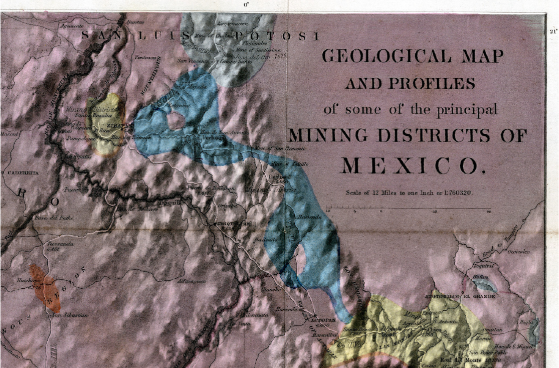
Figure 3 Excerpt of the 1827 geognostic map of central Mexico by von Gerolt and de Berghes (1864 edition), covering the Zimapán region.
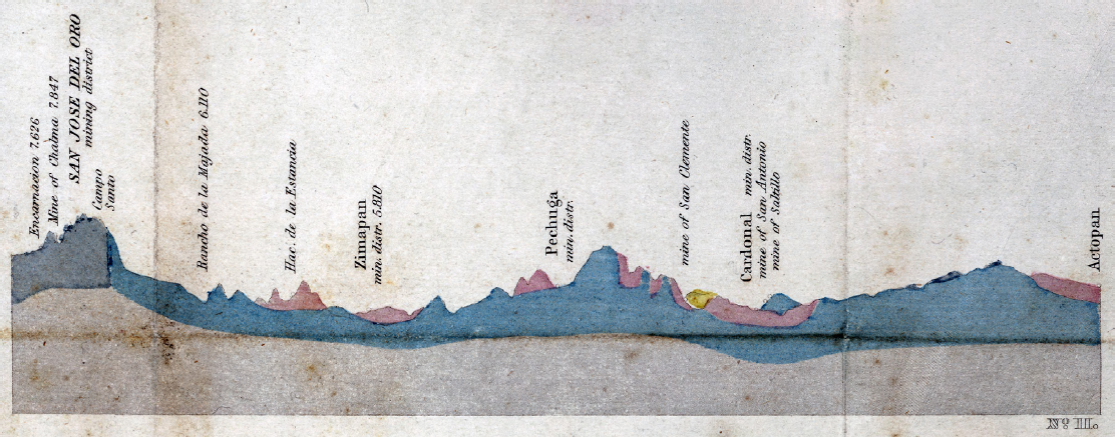
Figure 4 N-S geologic section from La Encarnación through Zimapán to Actopan by von Gerolt and de Berghes (1827), from the 1864 edition (profile II). The section trace, which is not a straight line, is indicated on Figure 3 by a partly white, partly black line, marked No. II. The topographic base of the sections is at 3000 feet. The vertical exaggeration is 15x.
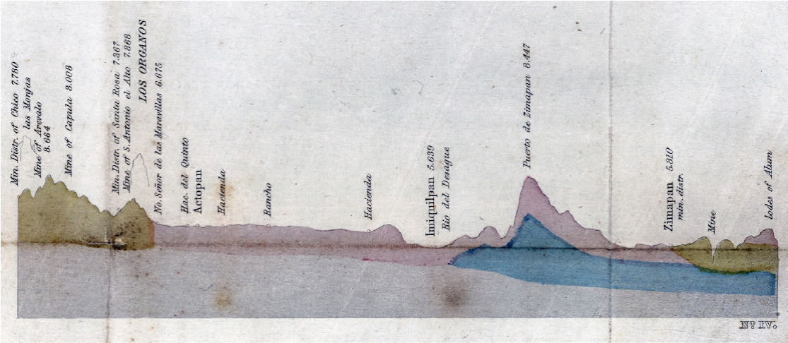
Figure 5 SE-NW geologic section from El Chico (Figure 1) through Actopan to Zimapán by von Gerolt and de Berghes (1827), from the 1864 edition (profile IV). The section trace is indicated on Figure 3 by a white line, marked No. IV. The topographic base of the sections is at 3000 feet. The vertical exaggeration is 15x.
The oldest map unit, colored in grey, is termed "primitive limestone and syenite". In the Zimapán region (Figures 3 and 4), this unit covers the area south of La Encarnación, including the San José del Oro mining district with the Chalma and Santísima Trinidad gold mines. In our present understanding, these are Eocene dioritic stocks (Kiyokawa, 1982) and limestone of the Cretaceous El Abra Formation (Suter et al., 1997, fig. 2).
The second map unit from the base, colored in blue, is termed "Silurian Slate Formation (metalliferous)." According to von Gerolt and de Berghes (1827), this unit forms the basement of much of central Mexico, including the mining districts of Tlalpujahua, Temascaltepec, and Sultepec (Figure 2). On their map, this slate unit covers the area east of Zimapán, where they describe it as calcareous and siliceous slate, as well as the area north and east of Cardonal, where they describe it as calcareous slate with limestone (Figures 3 and 4). East of Zimapán, it corresponds, in our present understanding, to the Upper Jurassic-Lower Cretaceous Las Trancas Formation as well as the Upper Cretaceous Soyatal and Méndez Formations (Suter et al., 1997, fig. 2). Whereas the contact between their limestone-syenite and slate units is vertical on their profile (Figure 4), von Gerolt and de Berghes (1827) report that at Camposanto (Figure 3) the slate unit rests horizontally upon the limestone-syenite unit.
Upsection follow the map unit termed "Metalliferous Porphyries," colored in yellow, and an equivalent unit of non-metalliferous volcanic rocks, colored in purple, which covers most of the map. According to von Gerolt and de Berghes (1827), these units are located everywhere upsection of the slate unit (Figures 4 and 5), specifically north of Zimapán, in the Barranca de Tolimán (Figure 4) and in the valley of the Moctezuma River, at Puente de la Seja (Figures 2 and 3; built in 1800 and now flooded by the reservoir of the Presa Hidráulica Zimapán). However, these outcrops are omitted from the map, possibly because of their small size. Neither do von Gerolt and de Berghes (1827) include the observations by Sonneschmid (1804) of limestone covering the Sierra El Doctor, west of the Moctezuma River (Figure 2), and the Sierra El Monte north of Zimapán, which they map as belonging to this volcanic unit. On the other hand, like del Río (1803) and Sonneschmid (1804) before them, they describe the high mountain range (with peak elevations > 3000 m above sea level), located southeast of Zimapán (Figure 3), now known as Sierra de Juárez (Figure 2), as being composed of volcanic rocks. In our present understanding, the rocks of these two map units partly belong to the silicic volcanic province of the Sierra Madre Occidental and partly to the trans-Mexican volcanic belt. The volcanic rocks of the Sierra de Juárez, mapped as Pachuca Group by Segerstrom (1962), belong to the former; the Pachuca Group has K-Ar ages between 25 and 27 Ma in the Sierra de Juárez (Kiyokawa, 1982) and ≥ 21 Ma in the Sierra de Pachuca (Figure 1; Dreier, 2005).
The youngest unit on the map by von Gerolt and de Berghes (1827), colored in red, are young volcanoes and their deposits, such as Nevado de Toluca, Popocatépetl, and Iztaccíhuatl. The Huichapan region is included in this unit (Figures 1 and 3), and from there they report extensive deposits of pumice, extracted by subterraneous mining. In our present understanding, these pumice deposits have a 4.2 Ma age and form part of the Donguinyó-Huichapan caldera complex (Aguirre-Díaz and López-Martínez, 2009).
4.2. The Cross Section by Hermann Joseph Burkart
Hermann Joseph Burkart was the technical director of the British Tlalpujahua Company 1825-1828 and occupied the same position in the British Bolaños Company 1828-1834, for which he worked in Zacatecas (Pferdekamp, 1958). In the time between these two assignments, Burkart visited the mining districts in central Mexico, including Zimapán. After his return to Germany, he published a book about the geology of central Mexico (Burkart, 1836). According to von Mentz (1982), Burkart tried to emulate von Humboldt, to whom he dedicated his work. The book includes a geologic map of the Zacatecas region. Previously, Burkart (1832) had already published the earliest geologic map and cross sections of a part of Michoacán State.
Burkart visited Zimapán in 1828. Like the Comisión Científica Novohispana in 1791, he approached Zimapán from Ixmiquilpan and left by way of Paso de las Maromas (located somewhat upstream of Puente de la Seja, Figure 2) to Tecozautla, Pathé, and Cadereyta (Figures 1 and 2). Burkart (1836, plate V) provides a very detailed cross section of the Zimapán area, which is based on his geological excursions. It is among the earliest published geologic cross sections of a region in Mexico after the sections by von Gerolt and de Berghes (1827, Figures 4 and 5), the Michoacán sections by Burkart (1832) mentioned above, and the cross section of the trans-Mexican volcanic belt drafted by Alexander von Humboldt in 1803 but only published in 1834, shortly before Burkart's book (von Humboldt, 1834, 2009; Beck and Bonacker, 1969).
Burkart (1836) provides a detailed description of the geology along the trail from Ixmiquilpan to Zimapán, which at that time passed the Sierra de Juárez mountain range at Puerto de Zimapán (Figures 2 and 3), approximately 5 km east of the present Highway 85. From the Ixmiquilpan region and the lower part of the ascent to Puerto de Zimapán, he reports limestone and fine-grained sandstone with some intercalated conglomerate layers, which in our present understanding are part of the Pliocene-Pleistocene Tarango Formation (Segerstrom, 1962; Kowallis et al., 1998). Higher up the trail, he describes dense, thin-layered limestone with thin chert intercalations, which he calls "Bergkalk". In our present understanding, this limestone belongs to the Tamaulipas Formation and is located in the western flank of the Bonanza anticline (Suter et al., 1997, fig. 1). The higher part of the mountain range, near Puerto de Zimapán, he describes as a hornblende-bearing feldspar-porphyry.
Burkart's (1836) major section of the Zimapán - La Encarnación region, here reproduced as Figure 6, extends from the Moctezuma River in the southwest to Cerro Cangandhó in the northeast, passing through Zimapán, Estancia, and San José del Oro. The approximate trace is marked on Figure 2. The legend indicates that the length scale of the section is amplified three times with respect to the length scale of the related map, which, however, Burkart did not include. The profile (Figure 6) shows much stratigraphic and structural detail, which he describes in the text. In the southwest, trachyte prorphyry overlies slate on either side of the Moctezuma River canyon. In our present understanding, these are volcanic rocks of the Las Espinas Formation overlying sediments of the Upper Cretaceous Soyatal Formation (Carrillo-Martínez, 2000). Towards the northeast, the section indicates porphyritic dikes intruded in slate near San Antonio, followed by a stock in the Tolimán River valley, and a red conglomerate overlying folded slate and limestone with an erosional unconformity near Zimapán (Figure 6). This configuration is comparable to the ones on the map by Carrillo-Martínez (2000) and on the locally more detailed map by Simons and Mapes (1956), who were apparently both unaware of the work by Burkart (1836). The red conglomerate is now known as the El Morro Formation (Carrasco-Velázquez et al., 2009 and references therein). Burkart infers the red conglomerate to be older than the many dikes by which it is intruded. The age of these dikes remains unstudied. The El Morro Formation has to be older than the Las Espinas volcanic rocks, which overlie conformably the El Morro Formation and interfinger with it locally (Simons and Mapes, 1956). Rocks of the Las Espinas Formation yielded a K-Ar age of 16 Ma near Puerto de la Estancia, close to their contact with the El Morro Formation (Suter et al., 1997, fig. 2).
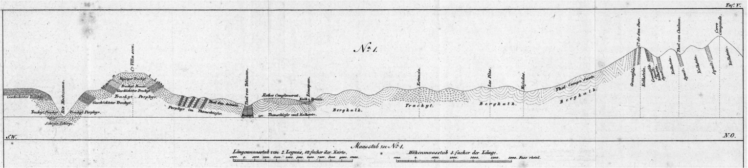
Figure 6 Geologic cross section between Zimapán and Cerro Cangandhó (La Encarnación) by Burkart (1836). The approximate trace of the section is marked on Figure 2 in blue.
Farther northeast, between Zimapán and Cerro de San José, the section by Burkart (1836) passes within folded "Bergkalk" and locally at La Estancia in trachyte (Figure 6). What Burkart mapped as "Bergkalk" belongs, in our present understanding, to the Lower Cretaceous Tamaulipas and El Abra Formations and the Upper Jurassic-Lower Cretaceous Las Trancas Formation, whereas the trachyte near La Estancia is now part of the Miocene Las Espinas Formation (Suter et al., 1997). Between Cerro de San José and Cerro Cangandhó, Burkart's section indicates massive limestone intruded by several major dikes of garnet-bearing syenite (Figure 6). In our present understanding, these are two Eocene stocks intruded into limestone of the El Abra Formation, which forms several roof pendants (Suter et al., 1997, fig. 2).
After leaving Zimapán, Burkart (1836) passed the El Pathé geyser (Figures 2 and 3), where he measured a temperature of 96 °C and observed an east-west alignment of nine springs on either side of the San Juan River valley. In our present understanding, these springs line up along an active fault of the Aljibes half-graben (Carrillo-Martínez, 1998, 2000).
4.3. The Contributions by Henri Guillaume Galeotti
Galeotti did field work in Mexico 1835-1840, sponsored by the Etablissement géographique Vandermaelen in Brussels, of which he was a graduate (Lasègue, 1845, p. 209-211; Quetelet, 1859). Contrary to the researchers studying the Zimapán area before him, who all had a background in mining, Galeotti had a wide range of interests in natural history, but is mostly remembered for his botanical studies (McVaugh, 1978; Diagre, 2004). His geological notes from Mexico cover earthquakes (Galeotti, 1841); the biostratigraphy of invertebrates (Nyst and Galeotti, 1840) including Cretaceous foraminifers (Galeotti, 1839a); ore deposits (Galeotti, 1838c, 1838d); and geological maps and profiles from the Lake Chapala (Galeotti, 1839b) and Zimapán (Galeotti, 1838a, 1838b) regions. His biostratigraphic studies are the earliest ones in Mexico (Alencaster Ybarra, 2013). Galeotti (1839b) seems prescient when he cursorily mentions the existence of active faults in the Lake Chapala region:
"La carte géologique qui accompagne ce mémoire a été dressée en partie sur les cartes existantes et en partie sur nos propres observations. ... Il n'existe probablement pas de carte géographique du pays pour indiquer les accidents du sol soulevé Ã une immense hauteur par d'assez récens phénomènes, fracturé en tous sens..."
Here, his map and sections of the Zimapán region, which are hand-colored lithographs, are reproduced as Figures 7 and 8, respectively (Galeotti, 1838a). Contrary to the map by von Gerolt and de Berghes (1827), neither a reference system nor a scale is indicated. The map uses shading (source of light in the north), which together with the drainage helps to visualize the relief. The map shows details along the trail from north of Ixmiquilpan over Puerto de Zimapán to Zimapán and on to Hacienda Tolimán (Figure 2), and between Zimapán and La Encarnación. The upper section (No. 1) on Figure 8 extends between Zimapán in the southwest and Cerro Cangandhó in the northeast; its trace is practically identical to the trace of Burkart's (1836) section (Figure 6) between these two locations (Figure 2). The lower section (No. 2) on Figure 8 is a local east-west section passing through Hacienda de la Estancia (Figure 7).
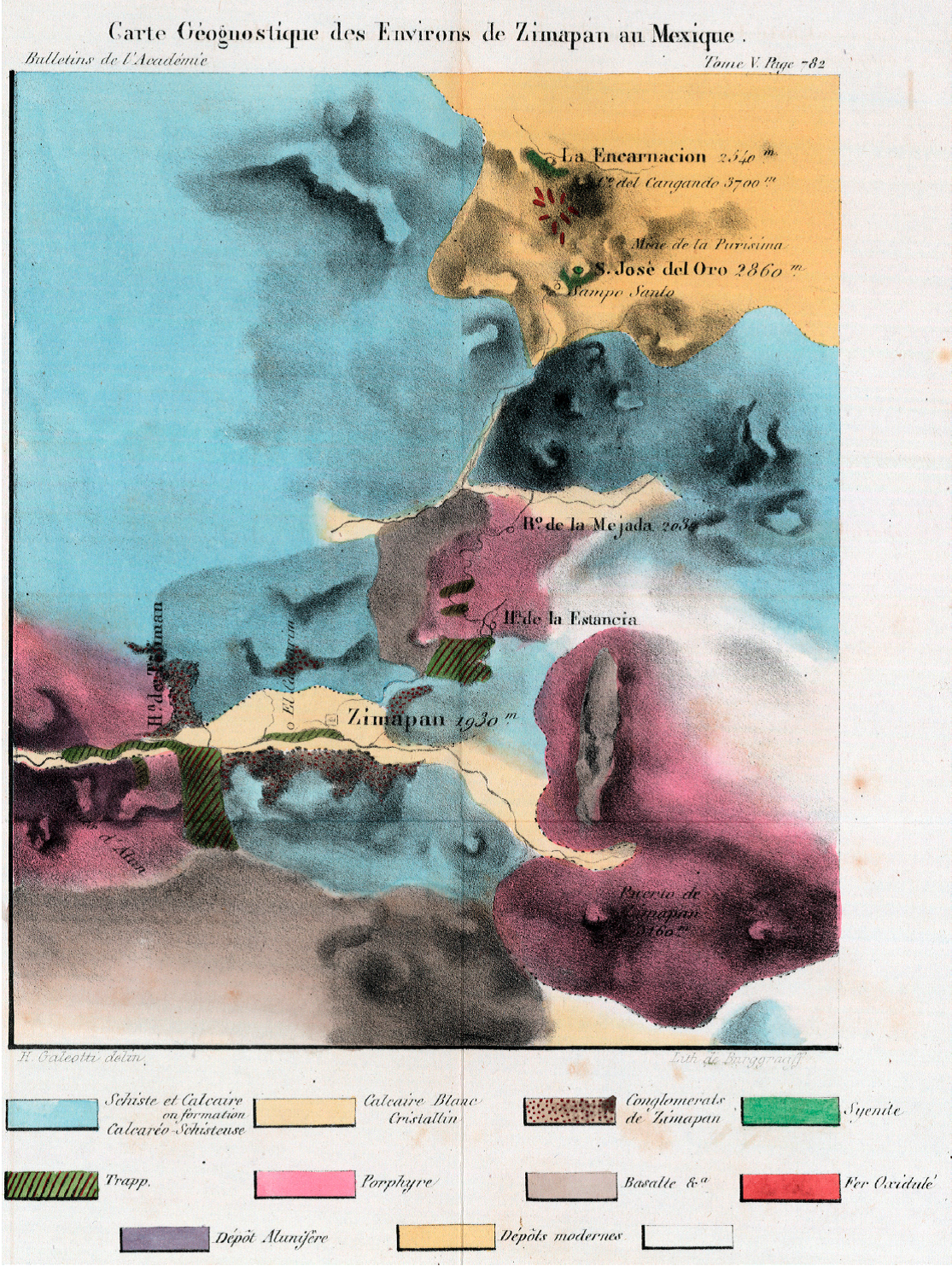
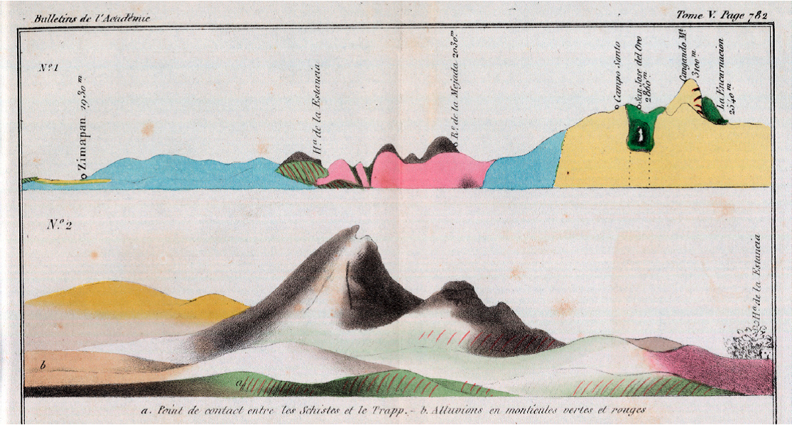
Figure 8 Geognostic cross sections of the Zimapán region by Galeotti (1838a). The trace of No. 1, which is a regional section, has an approximate northeast-southwest orientation. Its trace coincides with the northeastern part of the trace of the section by Burkart (Figure 6), which is marked in blue on Figure 2. No. 2, which is a local section, has an approximate east-west orientation and passes through Hacienda de la Estancia (trace marked in green on Figure 2).
Galeotti distinguishes ten lithological units (Figures 7 and 8), which he describes in the text (Galeotti, 1838b) and in the companion note about an alum deposit in the Barranca de Tolimán (Galeotti, 1838c). In the northeastern part of his map, he delimits two syenite stocks intruded into a unit of white crystalline limestone. He separates this unit from a limestone-slate unit on the remainder of the map, but interprets the white crystalline limestone to have been originally part of the limestone-slate unit before becoming metamorphosed by the intrusions. Based on specimens of the Seminario Nacional de Minería collection, he assumes the limestone to be of Cretaceous age ("étages supérieurs des terrains intermédiaires"). Furthermore, Galeotti distinguishes three volcanic units: a unit of fine-grained mafic rock (trapp) at the base, overlain sequentially by porphyry and basalt. A fairly detailed distribution of these three units is given for the Hacienda de la Estancia - Rancho de la Mejada area (Figures 7 and 8). Moreover, Galeotti mapped the red conglomerate of Zimapán and alluvium, as well as the magnetic iron ore deposits of the La Encarnación region and the alum deposit of Barranca de Tolimán. The map by Galeotti is much more detailed than the previous one by von Gerolt and de Berghes (1827, Figure 3). On the other hand, with exception of the Hacienda de la Estancia region (Figure 2), Galeotti's map is less detailed than the study by Burkart (Figure 6). However, given his wide background, Galeotti seems to have had a better grasp of the regional geology than Burkart, especially regarding stratigraphy. Galeotti (1838b) refers to the work by von Gerolt and de Berghes (1827) but was evidently unaware of the work by Burkart, which was published in Germany in 1836, whereas Galeotti arrived in Mexico in December of 1835 and did field work in the Zimapán area during the summer of 1836 (Quetelet, 1859; McVaugh, 1978).
5. Discussion
The early publications about the Zimapán area are first textual surveys and from 1827 on maps and sections with a gradually increasing level of detail. With exception of the work by Galeotti, these are lithological maps made by graduates of the Freiberg Bergakademie, based on Wernerian geognosy, and motivated by economic interests.
In his section, Burkart (1836) documents map-scale folds in the limestone of the Zimapán area (Figure 6), and from the profiles by von Gerolt and de Berghes (1827), it could be inferred that the slate and porphyry units are involved in map-scale folds between Pechuga and Cardonal (Figure 4) and in the Puerto de Zimapán region (Figure 5). However, these authors do not ponder mountain building. Werner's system did not recognize motions of the continental crust as a cause of inclined strata. An increasing amount of observations of map-scale folds and faults and their geomechanical explanation would only happen some 20 years later, in the middle of the 19th century (e.g., Darwin, 1840), and shortening by large-scale thrust faults of the Sierra Madre Oriental fold-thrust belt (Carrillo-Martínez and Suter, 1982; Suter, 1987; Suter et al., 1997; Contreras and Suter, 2015) and crustal extension by a system of major Cenozoic normal faults (Aljibes half-graben, Suter et al., 1995) would, in the Zimapán area, only be recognized in the late 20th century.
No further geologic studies seem to have been published about the Zimapán area after Galeotti's until the last third of the 19th century, a time of scientific renovation. Education and research were fomented by the scientific positivism of the time and became institutionalized during the governments of Benito Juárez and Porfirio Díaz (Trabulse, 1994; Saldaña and Cuevas Cardona, 1999; Morelos Rodríguez, 2012). The Comisión Geográfico-Exploradora (the national mapping agency of its time) was formed in 1877 and added a natural history section in 1879 (Cuevas Cardona, 2009). It is only during this period, beyond the scope of this review, that renewed studies of the Zimapán area were undertaken, such as the geologic mapping by Mariano Bárcena of the Zimapán region (Bárcena, 1877) and nearby parts of Querétaro State (Bárcena, 1873).
6. Conclusions
In the early 19th century, possibly no other region in Mexico was studied more geologically, and by more authors, than the Zimapán area. These studies occurred in two spurts; the first one in the early 1800s, and the second one in the 1820s to 1830s. Both seem to have been inspired by Alexander von Humboldt and were much constrained by political and economic circumstances.
The first group of publications about the Zimapán area was by scholars from the Real Seminario de Minería, coincided with Alexander von Humboldt's visit in Mexico 1803-1804, and marked an important step in the establishment of a geologic tradition in Mexico. All of the authors were graduates of the Freiberg mining school in Saxony and adherents of the theory of earth history by Abraham Gottlob Werner. The major contribution is the textual survey of the Zimapán area by Sonneschmid (1804) covering minerals, rocks, and ore deposits, which is based on field work and assaying of samples with a blowpipe and provides a nascent understanding of the regional lithostratigraphy based on the principles by Werner. The contributions by del Río (1803) and von Humboldt (1811) about the Zimapán region mostly rely on Sonneschmid (1804). The issue of the second part of the classical mineralogy textbook by del Río (1805), with a contribution by von Humboldt (1805) about the construction and use of geologic maps and sections, also falls into this period. This flourishing period was terminated by the war of independence and the related economic breakdown.
Mexico's need for foreign investment after gaining independence led to a legal opening, which resulted in a period of activity of German and British mining companies that, in turn, led to a new series of publications about the Zimapán area. These were not limited to textual surveys anymore, but included, for the first time, maps and sections. The ones of central Mexico by von Gerolt and de Berghes (1827) not only cover the Zimapán region but are also the earliest published geologic map and sections of any region in Mexico. Their base map builds on the previous topographic maps of central Mexico by Alexander von Humboldt (1811). Von Gerolt and de Berghes (1827) follow Werner's concepts in their identification of the sequence of rocks in central Mexico. On their geologic map, they roughly define the distribution of volcanic, sedimentary, and ore-bearing rocks based on a crude lithostratigraphy made up of five units. Their work is likely to have been guided by von Humboldt (1823), who verbally describes a section across the trans-Mexican volcanic belt between Oaxtepec in the south and the Sierra de Pachuca in the north (Figure 1).
This level of geologic knowledge is much improved locally by Burkart (1836), who published a cross section of the Zimapán area based on his fieldwork there in 1828. The section provides much structural and stratigraphic detail such as map-scale folds, the red conglomerate of Zimapán, and detail in the sequence of volcanic rocks. This period not only contains the publication of the 1803 section across the trans-Mexican volcanic belt by von Humboldt (1834), whom Burkart tried to emulate and to whom he dedicated his 1836 book, but also a second, much revised edition of the 1805 mineralogy textbook by del Río (1835a). These two contributions mark, somehow, the end of Wernerian geognosy in central Mexico.
The first local geologic map of the Zimapán region, a hand-colored lithograph with ten rock units, was published in 1838 by Galeotti together with cross sections and an explanatory text (Galeotti, 1838a, 1838b). It is based on his field work during the summer of 1836. The map has mostly less resolution than the 1836 section by Burkart. An exception is the Hacienda de La Estancia region, where Galeotti distinguishes three volcanic units: a unit of fine-grained mafic rock (trapp) at the base, overlain sequentially by porphyry and basalt. Contrary to the researchers studying the Zimapán area before him, who all had a background in mining, Galeotti had a wide range of interests in natural history. Consequently, his study introduces new concepts to the regional geology of the Zimapán area, such as biostratigraphy and metamorphism. No further geologic studies seem to have been published about the Zimapán area after Galeotti's until the geologic mapping by Mariano Bárcena during the last third of the 19th century.

