


Servicios Personalizados
Revista
Articulo
 Inglés (pdf)
 Artículo en XML
 Referencias del artículo
 Enviar artículo por email
Indicadores
-
 Citado por SciELO
 -
 Accesos
Links relacionados
-
 Similares en
SciELO
Similares en
SciELO
Compartir

 Permalink
Agrociencia
versión On-line ISSN 2521-9766versión impresa ISSN 1405-3195
Agrociencia vol.45 no.3 Texcoco abr./may. 2011
Agua-suelo-clima
Relations between hidrogeomorphic attributes of the Dourados basin-Brazil and their enviromental signficance
Relaciones entre atributos hidrogeomorfológicos de la cuenca del río Dourados y su importancia ambiental
Samantha Alcaraz1, Omar Daniel2*, A. Carlos Tadeu-Vitorino2, Christophe Sannier1
1 Cranfield University, Department of Natural Resources, Silsoe Bedfordshire MK43 0AL, UK, United Kingdom. (samantha.alcaraz@gmail.com), (christophe.sannier@sirs-fr.com).
2 Universidade Federal da Grande Dourados, Faculdade de Ciencias Agrarias, 79.825-070 Dourados-MS. (omar.daniel@pq.cnpq.br), (antoniovitorino@ufgd.edu.br). * Author for correspondence.
Received: June, 2010.
Approved: March, 2011.
Abstract
The study of the morphometry within of catchment boundaries allowed to quantify aspect of the fluvial system in relation to geology, geomorphology and hydrology of the basin of Dourados river, Brazil, making possible to analyse the relations between hydrographic and environmental properties like the first step to better understand the processes taking place within the catchment area. The drainage network was described using qualitative and dimensional observations, from which significant quantitative attributes were derived, including interpolated drainage density and drainage frequency. Environmental data such as geology, geomorphology and soils type were acquired to allow an interpretation of their relationships with the drainage network. The geomorphologic and hydrologic characteristics confirm that the drainage system is strictly dependent on the nature of the bedrock, and on its regional and local structural control. Basaltic lava flow and associated soils shape tabular landforms where dendritic network of low drainage density and low density of dissection are develop. On sandstone and residual basal conglomerate, the drainage frequency is lower but the relief variation is locally increased by erosion processes that create deep and narrow valleys. The drainage network does not appear strongly influenced by regional tectonic control. Nevertheless, lineaments on NW-SE and NE-SW trends could be related to structural constraints affecting the western area of the sedimentary Paraná basin, in relation to the Andine orogeny. To highlight the influence of soil distribution on the drainage network, a smaller area of interest would need to be selected.
Key words: hydrogeomorphology, watershed, catchment.
Resumen
El análisis morfométrico de las zonas de captación permitió cuantificar aspectos del sistema fluvial en relación con la geología, geomorfología e hidrología de la cuenca del Río Dourados, Brasil, lo que permitió estudiar las relaciones entre las propiedades hidrográficas y ambientales como el primer paso para entender mejor los procesos que se llevan a cabo dentro del área de captación. El sistema de drenaje se describió usando observaciones cualitativas y dimensionales, de las que derivaron atributos cuantitativos importantes, incluyendo densidad de drenaje y frecuencia de drenaje por interpolación. Se obtuvo información sobre el ambiente, como la geología, la geomorfología y los tipos de suelo, para interpretar sus relaciones con el sistema de drenaje. Las características geomorfológicas e hidrológicas confirman que el sistema de drenaje depende rigurosamente de la naturaleza del cimiento, así como de su control estructural regional y local. La corriente de lava basáltica y los suelos asociados conforman relieves tabulares donde se desarrolla un dendrítico de baja densidad de drenaje y baja densidad de disección. En las areniscas y los conglomerados basales, la frecuencia de drenaje es menor, pero la variación de los relieves aumenta localmente por los procesos de erosión que generan valles profundos y estrechos. Al parecer, el sistema de drenaje no está fuertemente influenciado por el marco tectónico regional. Sin embargo, las tendencias lineales georesistivas en direcciones NO-SE y NE-SO podrían deberse a limitaciones estructurales que afectan la zona occidental de la cuenca sedimentaria del Paraná, en relación con la orogenia andina. Para destacar la influencia de la distribución del suelo sobre el sistema de drenaje se necesita seleccionar una área menor de interés.
Palabras clave: hidrogeomorfología, interfluvio, captación.
Introduction
The Dourados hydrographic basin, a subsidiary of the Paraná river, is located south of the state of Mato Grosso do Sul, south-eastern Brazil, and covers an area of 9205.41 km2 (Mato Grosso do Sul, 2000). The Dourados River is the main supplier of fresh water for human consumption in Mato Grosso do Sul and maintaining its water quality environmental and natural resources management is necessary.
The first step to better understand the processes taking place within the basin is to study the relations between hydrographic and environmental properties. The catchment boundary defines an area which is often considered as the most basic unit of monitoring, analysis and management (Brown and Harper, 1999). The study of the basin morphometry within these boundaries will allow to quantify numerically and mathematically aspect of the fluvial system in relation to geology, geomorphology and hydrology of the basin (Clarke, 1966; Martínez-Casasnovas and Stuiver, 1998; Oliveira and Ferreira, 2001).
The expansion of digital representation has stimulated the development of automatic procedures to extract topographic and hydrologic information from Digital Terrain Models (DEM), using GIS software packages and hydrologic models that integrate multiple databases within a minimal time (Lin et al., 2005). These methods are objective, fast to implement, and allow multi-criteria analyses.
The objective of this study was to characterise the drainage network of the Dourados catchment using qualitative and quantitative attributes, comparing raw topographic data and drainage networks form pre-processed digital terrain models, and to establish the relations between these geomorphologic and hydrologic attributes and their significance in terms of the actual geomorphology and geology of the area.
Material and Methods
Land morphology and channel network properties of the Dourados hydrographic basin were analysed using qualitative and quantitative attributes extracted from topographic data and digital terrain models, in relation to the watershed boundary. The processes of defining adequately the boundary of the basin and the automatic generation of the drainage network have been described by Alcaraz et al. (2009). Once determined, the drainage characteristics are interpreted in relation to gathered geological and geomorphological data.
Dourados hydrographic basin
The Dourados hydrographic basin is located south of the Mato Grosso do Sul state (21° 56' S - 53° 59' W) and annual rainfall varies between 1300 to 1750 mm (Arai et al., 2010). This basin covers 11 municipal districts, with 368 956 inhabitants (IBGE, 2010), and concentrate activities of intensive farming and agricultural development due to fertile soils, gentle slope and appropriate climate. Rio Dourados, the main river of the basin, flows from the Serra de Maracaju near the town of Antonio Joáo (Figure 1) and evolves 370 km from west to east until joining Rio Brilhante.
The Dourados catchment area belongs to the vast Paraná sedimentary basin, filled with 7000 m of sedimentary and igneous rocks, and located at the southern boundary of the Amazonian platform. The surface geology of the basin itself is homogeneous and limited to the Sao Bento group, including formation Serra Geral (JKsg), and the Bauru group with formations Ponta Pora (Qpp) and Caiuá (Kc). The geological description of the formations in the basin of Dourados (Almeida, 1946; RADAMBRASIL, 1982; Courtillot and Renne, 2003) can be summarized as follow: the Serra Geral formation is made up of massive, dark grey, basaltic lava flows with layers of sandstone in the lower unit, usually 1 to 2 m thick, and they are related to numerous sills and dykes of diabases; basalts in outcrops often show spheroid weathering; the Bauru group is represented by medium to fine sandstone intercalated with rounded gravels and conglomerates; pebbles are of volcanic and metamorphic origin in the lower layers, while the sedimentary influence is stronger in the upper units; the formation is strongly weathered and rich in clay.
The geomorphology of the area is characterised by the Maracaju - Campo Grande plateaux, lined up along the basaltic escarpment of Serra de Maracuju. The Dourados plateau itself is sculpted in the Serra Geral basaltic rocks, locally covered by the Bauru sandstones, forming flat inter-fluvial relieves slightly inclined towards the south-east with elevation decreasing from 500 m to 300 m. Basalts shape tabular landform (t41, t51, Ep) associated to shallow valleys (RADAMBRASIL, 1982), where the basalts are covered by the Bauru sandstones, landforms are rounded (c22, c31, t31), and conglomerated form residual hills (c23) (RADAMBRASIL, 1982).
Methodology
The morphometric attributes of the Dourados hydrographic basin were firstly computed from the printed data layers; the Dourados basin was outlined from aerial photography interpretation; rivers, contours and spot height data were digitised from topographic maps. The same procedure was then applied to pre-processed digital terrain models and drainage network using GIS packages (Alcaraz et al., 2009). Two DEM were used for this study: 1) a 50 m resolution DEM formed from the interpolation of digitised contour lines and spot height data (processed via Topogrid, ArcInfo); 2) a 90 m resolution SRTM DEM acquired by interferometry radar. Interpretation must take in account the grid scale which greatly influences the details of information extracted, as some hydrological and geomorphological attributes might be lost (Hancock, 2005).
The qualitative and quantitative attributes extracted for geomorphological classification and drainage analyses, comparing automatically generated drainage networks and raw data digitised from topographic maps, are summarised in Table 1 and 2.
Hypsometry is the measurement of land elevation relative to sea level. It provides a quantitative method for analyzing the geometric form of the catchment, describing the elevation as a function of the total basin area (Luo, 1998). The hypsometric integral gives a measure of the degree of dissection of a landscape (Evans, 1972) and the extent to which topography is opened up by erosion (Clarke, 1966). Two methods were used:
1) Estimation of the hypsometric integral from a simple calculation (Equation 1):
2) Using the DEM to create classes of elevation, 10 groups in this case, and to extract their respective areas to generate a hypsometric curve and its integral.

The drainage was specifically studied according to its pattern type and its texture, also known as density of dissection (Way, 1973). While the first parameter is associated to the nature and structure of the substratum (Howard, 1967), the second is related to rock and soil permeability.
Stream ordering is directly proportional to the watershed dimensions, channel size and discharge (Strahler, 1957). The determination of the stream segments hierarchy was made manually. The bifurcation ratio and length relation refer to factors governing the structure of the various stream attributes in a similar predictable way, certainly linked to the watershed geomorphology. Diverse aspects of drainage network were also found to be quantifiable, such as the drainage density and the drainage frequency. Both attributes were averaged for the entire Dourados basin, but their variableness within the basin was also analysed.
All these attributes were compared to the geological and geomorphological data assembled. Maps were created and combined using GIS spatial analyses capabilities to highlight key relationships between these attributes.
Results and Discussion
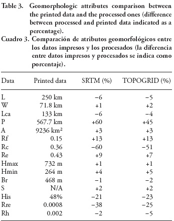
The Dourados hydrographic basin has the form of a curved ellipse (250 km length and 72 km width), a dimensionless circulatory ratio of 0.36 and an elongation ratio of 0.43 (Table 3). The basin relief is 468 m between the highest point in the Serra de Maracaju and the outlet, inducing low relief ratio and low relative relief values. Average slope variation is 1.99 %, with the top of the plateau and plains being less than 1 %, valley walls varying from 2 to 5 %, and locally reaching up to 10 %. The same geomorphologic attributes extracted for the drainage networks generated by automatic methods commonly present a good correlation, with differences up to 5 % for the manual extraction (Garbrecht and Martz, 1993).
Elevation for two-thirds of the entire basin area varies between 340 and 525 m. The estimation of the hypsometry (Equation 1) gives a value of 48 %, whereas the derived integral built from the exact hypsometric curve, which gives a better estimation of the distribution of land mass above the outlet datum, is 61 % (Figure 2).

These geomorphological attributes characterise an elongated basin, with very gentle slope, favouring run-off to be spread out. The hypsometric integral expresses the volume of the original basin still in situ; 61 % indicates that the basin morphology is still susceptible to erosion. This is typical of a basin developed on resistant lithography or soils with good water infiltration and low run-off. Vitorino et al (2003) report the importance of the mineralogy of Oxisols in the genesis of its structure, which often defines their high permeability (Ferreira et al., 1999). Such characteristic of these soils confers resistance to erosion and can be confirmed by the study from Arai et al. (2010) where we observe small values for the erodibility of the soils in the basin.
The drainage qualitative properties can be summarised as follow: 1) the Dourados hydrographic basin presents a dendritic drainage pattern and meandering channels; 2) the stream integration is generally good, especially up-stream, as well as the uniformity for the printed and SRTM data sets; 3) there is no general orientation of the streams, but local NW-SE and NE-SW trends are noticeable; 4) they coincide with a regional scale control influence.
Looking at the entire SRTM DEM, that covers the south of Mato Grosso do Sul, it becomes apparent that both orientations point out the structure of the western Paraná sedimentary basin. However, at a local scale the channel directions are variable and streams junction are mainly acute. Quantitative attributes for the three data sets are presented in Table 4.
The reference data set and the automatically generated ones present clear dissimilarities due to the issues encountered in generating the channel pattern in flat area (Alcaraz et al., 2009). Concentrating on the printed data set, the maximum stream length is 437 km for a valley length of only 250 km. The qualitative description are corroborated by the quantitative and systematic attributes such as: the texture is coarse, the drainage density evolves from 0 to 1305 m km -2 (Figure 3), with a low average of 360 m km -2, and the frequency varies from 0 to 0.987 (Figure 4) with a small average of 0.07. The sinuosity variation is high and the meanders wavelength down to only 250 m for streams of order 4 and 5. It does indeed characterize a permeable and well-vegetated landscape, with few streams and low run-ofF in area of smallest slope gradient, favouring the development of ponds, swamps and meanders. A coarse texture value is also an indication of a bedrock resistant to the erosion, which is confirmed by the distribution of soils relatively resistant to the process of erosion in this area (Hernani et al., 1999; Panachuki et al., 2006).
Data derived from automatic processes tend to overestimate the number of streams (Table 4); however, the relationships between stream orders and channels properties are strong (Figure 5), and the bifurcation and length ratios are consistent. Bifurcation ratios of 4 to 5 are typical of a drainage developed on homogeneous geology without a strong structural control influence (Strahler, 1964), confirming the orientation and structural control observations at local scale.
Drainage density and stream frequency are continuous surfaces interpolated over the entire Dourados basin (Figures 3 and 4). Spatial analyses using GIS capabilities allow investigation of the influence of geomorphology and geology on the drainage density and frequency. The stream frequency associated to the Bauru formation (Qc, Qpp) is on average lower than 0.2 (Figure 6). The lowest values in relation with geomorphology are 0.22 and 0.3, units c22 and c31, which are typically associated with the Bauru formation. They represent dissected landscape of convex relieves due to the basal residuals conglomerates of Bauru sandstone that can formed residuals mounts and favours higher dissection depth. The drainage density is relatively high for the tabular relief (t31) that dominates in the western part of the basin, where the average stream density reach 417 m km2.

The Serra Geral (JKsg) formation in average has frequency value higher than 0.2 and density above 2250 m km2. The geomorphological units associated with the formation (t41 and t51) confirm it with frequency values of 0.38 and 0.36. These sub-units characterize gentle, tabular and poorly dissect relieves formed in relation to the resistant basalt flood. The density on these areas is about 340 m. It is smaller than for the t31 relieve previously described and is then in accord with the classification of RADAMBRASIL (1982) that estimated drainage intervals of 750 to 1750 m for t31, and only 1750 to 12750 m for t41 and t51.
It is also consistent to notice that globally the drainage frequency is higher in soils formed by the decomposition of the basalt of the Serra Geral formation, that those soil characteristics of the Bauru formation. The drainage density in relation with the soils is heterogeneous and does not show any evident relationship. A smaller scale of work would be necessary as the drainage network is not enough precise in relation with the accuracy of the soil distribution.
Conclusions
The geomorphologic and hydrologic attributes were sufficient to confirm that in Dourados basin area the drainage system is strictly dependent on the slope, the nature of the bedrock and its regional and local structural control.
The soils developed over the basalts of the Serra Geral formation shape tabular relieve associated to a dendritic network of low drainage density and low density of dissection. Where basalt is covered by sandstone and residual basal conglomerate of the Bauru formation, the drainage frequency is lower but the relief variation and slope are locally higher, due to weaker materials, increased dissection rate and a deepening of V-shaped valleys.
Nevertheless, drainage is not influenced by a strong tectonic control; regional lineaments on NW-SE and NE-SW directions trace the structural constraints on the western part of the sedimentary Paraná basin related to the Andine epirogeny.
The soils distribution is also directly linked to the geology, as they result of the decomposition of the underlying bedrock, but a smaller scale of work would be necessary to highlight their influence on the drainage network.
Literature Cited
Alcaraz, S. A., C. Sannier, A. C. T. Vitorino, and O. Daniel. 2009. Comparison of methodologies for automatic generation of limits and drainage networks for hydrographic basins. Rev. Bras. Eng. Agríc. Ambient. 13(4): 369-375. [ Links ]
Almeida, F. F. 1946. Depósitos mesozóicos do planalto de Maracaju, Estado de Mato Grosso. In: Congresso Panamericano de Engenharia de Minas e Geologia. [ Links ]
Arai, F. K., G.G.G. Goncalves, S.B. Pereira, E. Comunello, A.C.T. Vitorino, e O. Daniel. 2010. Espacialização da precipitação e erosividade na bacia hidrográfica do Rio Dourados - MS. Engenharia Agríc. 30(5):922-931. [ Links ]
Brown, A. G., and D. Harper. 1999. Sustainability in the context of tropical catchments. In: Harper, D., and A. G. Brown (eds). The Sustainable Management of Tropical Catchments. Wiley: Chichester. pp: 3-18. [ Links ]
Clarke, J. I. 1966. Morphometry from maps. In: Dury, G. H. (ed). Essays in Geomorphology. Heinemann, London. pp: 235-274. [ Links ]
Courtillot, V., and P. R. Renne. 2003. On the ages of flood basalt events. C. R. Geosci. 335: 113-140. [ Links ]
Evans, I. S. 1972. General geomorphometry, derivatives of altitude, and descriptive statistics. In: Chorley, R. J. (ed). Spatial Analysis in Geomorphology. British Geomorphological Research Group, New York. pp: 17-90. [ Links ]
Ferreira, M.M., B. Fernandes, e N. Curi. 1999. Influência da mineralogia da fração argila nas propriedades físicas de latossolos da região Sudeste do Brasil. Ver. Bras. Ciência do Solo 23(3): 515-524. [ Links ]
Garbrecht, J., and L. Martz. 1993. Network and subwatershed parameters extracted from digital elevation models - the Bills Creek experience. Water Resour. Bull. 29: 909-916. [ Links ]
Hancock, G. R. 2005. The use of digital elevation models in the identification and characterization of catchment over different grid scales. Hydrol. Processes 19: 1727-1749. [ Links ]
Hernani, L. C., C. H. Kurihara, e W. M. Silva. 1999. Sistemas de manejo de solo e perdas de nutrientes e matéria orgânica por erosão. Rev. Bras. Ciênc. Solo 23(1): 145-154. [ Links ]
Horton, R. E. 1945. Erosional development of streams and their drainage basins, hydrophysical approach to quantitative morphology. Bull. Geol. Soc. Am. 56: 275-310. [ Links ]
Howard, A. D. 1967. Drainage analysis in geologic interpretation: a summation. A.A.P.G. Bull. 51(11): 2246-2259. [ Links ]
IBGE - Instituto Brasileiro de Geografía e Estatística. 2010. Banco de dados agregados. sidra.ibge.gov.br. (Consultado: maio, 2010). [ Links ]
Lin, W.-T., W.-C. Chou, C.-Y. Lin, P.-H. Huang, and J.-S. Tsai. 2005. Automated suitable drainage network extraction from digital elevation models in Taiwan's upstream watersheds. Hydrol. Processes 20(2): 289-306. [ Links ]
Luo, W. 1998. Hypsometric analysis with a geographic information system. Comput. Geosci. 24: 815-821. [ Links ]
Martínez-Casasnovas, J. A. and H. J. Stuiver. 1998. Automatic delineation of drainage networks and elementary catchments from Digital Elevation Models. Int. J. Aerospace Survey Earth Sci. (ITC J.) 3(4): 198-208. [ Links ]
Mato Grosso do Sul. 2000. Bacia Hidrográfica do Rio Dourados: Diagnóstico e implantação da rede básica de monitoramento da qualidade das águas. Secretaria de Estado de Meio Ambiente, FEMAP/MS, Coordenadoria de Recursos Hídricos e Qualidade Ambiental. Campo Grande, Brasil. 78 p. [ Links ]
Oliveira, A. e E. Ferreira. 2001. Caracterização de sub-bacias hidrográficas. UFLA-FAEPE. Lavras, Brasil. 64 p. (Textos acadêmicos). [ Links ]
Panachuki, E., A. C. T. Vitorino, T. Alves Sobrinho, D. F. Carvalho, e M. A Urchei. 2006. Parâmetros físicos do solo e erosão hídrica, sob chuva simulada, em sistema de integração agricultura-pecuária. Rev. Bras. Eng. Agríc. Ambient. 10: 261-268. [ Links ]
RADAMBRASIL. 1982. Mapa Geológico, SF. 21 Campo Grande. Ministério das Minas e Energia. Brasília, Brasil. [ Links ]
Strahler, A. N. 1957. Quantitative analysis of watershed geomorphology. E.O.S. T. Am. Geophys. Un. 8(6): 913-920. [ Links ]
Strahler, A. 1964. Quantitative Geomorphology of Drainage Basins and Channel Networks. In: Chow (ed). Handbook of Applied Hydrology. New York: McGraw-Hill. [ Links ]
Vitorino, A.C.T., M.M. Ferreira, N. Curi, J.M. de Lima, M.L.N. Silva, e P.E. F. Motta. 2003. Mineralogia, química e estabilidade de agregados do tamanho de silte de solos da região do sudeste do Brasil. Pesquisa Agrop. Bras. 38:133-141. [ Links ]
Way, D. S. 1973. Terrain Analysis: A Guide to Site Selection using Aerial Photographic Interpretation. Dowden, Hutchinson & Ross Inc. Stroudsburg, PA. 392 p. [ Links ]

