


 nueva página del texto (beta)
 Inglés (pdf)
 Artículo en XML
 Referencias del artículo
 Enviar artículo por email
 Citado por SciELO
  Similares en
SciELO
Similares en
SciELO 
 Permalink
Introduction
The benefits and importance of urban forests1 in cities around the world have been documented extensively; trees within urban areas have a significant influence on water, air and pollution cycles (Livesley, McPherson, & Calfapietra, 2016), and also provide with sociological, economic, and aesthetic benefits (Garvin & Brands, 2011; Perino et al., 2014). Therefore, adequate management of the urban forest is indispensable for a sustainable and livable city (Chiesura, 2004).
Urban Forestry- “generally defined as the art, science, and technology of managing trees and forest resources in and around urban community ecosystems” (Konijnendijk et al., 2006; p.2)- has been present in urban settlements in America as early as the 1890s, and the practice keeps evolving to address current problems with new tools. During the XXI century, in North America and Europe, the management of urban trees has centered largely on reforestation and the resulting urban forestry programs (Konijnendijk, 2003; Kroeger et al., 2014; Nilsson et al., 2010). As a general trend, the use of technology has transformed positively the way trees are managed in urban contexts; for instance, the use of satellite remote sensing and Geographic Information Systems (Miller, Hauer, & Werner, 2015); modern data science has allowed experts and decision-makers to formulate urban forest models and policies based on detailed socio-ecological information collected by academic and governmental institutions, non-governmental organizations, and even individual citizens.
In addition to new technologies, a key component of urban forest management is the participation of citizens in the formulation and operationalization of public policy directed to trees and other vegetated areas of the city. Traditional top-down decision-making processes have been substituted with a participatory governance approach that spurs citizens and stakeholders to collaborate on addressing socio-ecological problems. Participatory governance, a widely used term in European political science literature (Fung, 2015), predicates upon the citizen's role beyond voter or watchdog; participatory governance includes practices of direct deliberative and operational engagement with pressing issues (Fischer, 2012).
The participation of diverse non-expert actors is essential for adequate urban forest management due to the fact that it can yield large amounts of data remotely; for example, on-line tools have been broadly used to generate urban forest inventories and to collect other types of information (see i-tree and other platforms; e.g. Hirabayashi & Kroll, 2017; Nowak, Maco, & Binkley, 2018; Pace, Biber, Pretzsch, & Grote, 2018). Environmental management literature refers to this active interaction of a diverse group of actors towards a common goal as adaptive co-management. Adaptive co-management (ACM) is generally understood as ‘‘a process by which institutional arrangements and ecological knowledge are tested and revised in a dynamic, ongoing, self-organized process of trial-and-error’’ (Folke et al., 2002, p. 8; in Baird, Plummer, & Bodin, 2016). It implicates mixed actors cooperating across scales and through institutional and formal/informal channels (horizontally and vertically) to undertake actions and learn through feedback (Armitage et al., 2009).
ACM has been implemented in several cities to improve and expand the participatory monitoring of trees and the urban forest in general (Baird et al., 2016; Pace et al., 2018; Van der Jagt et al., 2019). Mexico City is an illustrative example of ACM applied for monitoring urban trees because of two reasons. First, with the explicit objective to spur civic participation, the Mexican federal government funded Naturalista, a science divulgation online platform administered by the National Commission for Biodiversity Knowledge and Use (in Spanish, Comisión Nacional para el Conocimiento y Uso de la Biodiversidad, CONABIO). Naturalista was originally designed after iNaturalist, a citizen science project and online social network devised to map and share observations of biodiversity across the globe. As of 2018, CONABIO’s Naturalista has registered 26637 observations of trees in Mexico City and is rapidly consolidating as a salient and legitimate participatory tool useful for monitoring the urban forest. Secondly, aiming to increase the cooperation among diverse actors, the task of reporting on the progress of reforestation has been officially given to the Environment and Land Management Agency for the Federal District (in Spanish Procuraduría Ambiental y del Ordenamiento Territorial del Distrito Federal, PAOT). The PAOT has been logging information on urban trees in Mexico City since 2013; the “arboreal census” of Mexico City has been conducted with the help of scientific experts and has registered 20122 trees. ACM of the urban forest in Mexico City has been implemented for almost a decade but it is yet to be scrutinized.
This article presents a spatial and statistical analysis of the distribution of trees monitored by both systems of PAOT and Naturalista to determine if and how ACM can be a productive approach for urban forests. Considering the current state of environmental degradation suffered in México City and other super populated cities of the world, it is indispensable to assess institutionalized mechanisms used to manage natural resources in urban contexts.
Materials and methods
Study site
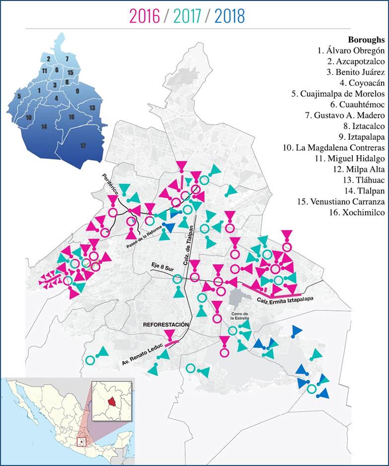
Mexico City has a total area of 1,485 km2 (573 sq. mi) and a population of 8.851 million (INEGI, 2010). In addition, the Metropolitan Area of Mexico City (MCMA) comprise 16 boroughs, 59 municipalities of the state of Mexico and 29 municipalities of the state of Hidalgo- the aggregate population is approximately 21.3 million (Delgado, 2012). It is the city with the highest population density in Latin America (Habitat, 2012). Given the massive size of the MCMA and for practical reasons, this research concentrated only in Mexico City and its 16 boroughs. This research used the Mexico City reforestation program of 2016-20182 as a spatial reference for this analysis. That is, to determine were ACM monitoring efforts should be directed.
According to the official report by the Mexico City Environment Secretariat (in Spanish, Secretaria del Medio Ambiente del Distrito Federal, SEDEMA), the reforestation program processed a total of 6379 trees within nine of sixteen boroughs using a $50 MXP million (~$260,000 USD) budget (Table 1). Notice that Iztapalapa, Cuauhtémoc and Alvaro Obregon were significantly favored compared to other boroughs (Map 1). This data provides important information regarding the specific geographical areas of the city were reforestation has been taking place. In the case of Iztapalapa, this high reforestation tendency may respond to the fact that the borough was reported to be significantly underserved with green public space (Fernández-Álvarez, 2017) and urban vegetation in general (Maldonado-Bernabé et al.,2019). In the cases of Miguel Hidalgo, Alvaro Obregon and Cuauhtémoc, these boroughs have been hosting the large majority of green public spaces and urban vegetation in the city (i.e. Chapultepec Forest, Alameda Central Park, Parque Mexico, etc.) and have been historical priorities for the Mexican administrations through the years (Wakild, 2007). It is important to highlight that this research was not limited to analyze the 2016-2018 Reforestation Program, but included data provided by both systems of PAOT and Naturalista for the 16 boroughs of the city.
Table 1 Mexico City Reforestation Program per borough 2016-2018.
| Trees planted per year | |||||
|---|---|---|---|---|---|
| Mexico City Boroughs | 2016 | 2017 | 2018 | Totals per borough | % of total reforestation |
| Azcapotzalco | 0 | 0 | 0 | 0 | 0.00 |
| Coyoacán | 19 | 209 | 0 | 228 | 3.57 |
| Cuajimalpa de Morelos | 355 | 250 | 0 | 605 | 9.48 |
| Gustavo A. Madero | 0 | 0 | 0 | 0 | 0.00 |
| Iztacalco | 0 | 0 | 0 | 0 | 0.00 |
| Iztapalapa | 1134 | 792 | 53 | 1979 | 31.02 |
| La Magdalena Contreras | 0 | 0 | 0 | 0 | 0.00 |
| Milpa Alta | 0 | 0 | 0 | 0 | 0.00 |
| Álvaro Obregón | 1497 | 37 | 0 | 1534 | 24.05 |
| Tláhuac | 0 | 324 | 176 | 500 | 7.84 |
| Tlalpan | 33 | 44 | 0 | 77 | 1.21 |
| Xochimilco | 67 | 101 | 0 | 168 | 2.63 |
| Benito Juárez | 0 | 156 | 0 | 156 | 2.45 |
| Cuauhtémoc | 239 | 189 | 96 | 524 | 8.21 |
| Miguel Hidalgo | 175 | 167 | 0 | 342 | 5.36 |
| Venustiano Carranza | 33 | 231 | 2 | 266 | 4.17 |
| Totals | 3552 | 2500 | 327 | 6379 | 100.00 |
Source: adapted from data included in the Programa de Reforestación CDMX 2016-2018 available at https://bit.ly/2CeLOg7
Methodological Approach
Urban forests have been studied with a suit of varied methods. In the particular case of distribution of urban trees or urban vegetation a combination of statistical and spatial analysis is the academic standard; specifically, geostatistical interpolation has been a widely used tool for green public spaces such as parks and other forms of green public space (Boone et al., 2009; Nesbitt, Meitner, Girling, & Sheppard, 2019; Yang, Xiao, & Ye, 2016). Spatial analysis has been used to unveil patterns of concentration in specific areas of a city; classical studies on environmental justice and other sorts of distributional studies have shown that trees are not equitable allocated in the urban space, but rather concentrated on white-affluent areas of cities (see Boone et al., 2009; Oh & Jeong, 2007; Sister, Wolch, & Wilson, 2009). The ubiquitous statistical dimension in these studies responds to the fact that most spatial data contains also demographic features useful to determine if there are correlations among gender, age, education level, race or income (e.g. Nesbitt, Meitner, Girling, Sheppard, & Lu, 2019). For these reasons, the current research applied a spatial distribution analysis coupled with a simple categorical regression calculated from data provided by both the PAOT and Naturalista systems. The spatial distribution analysis was conducted using QGIS 3.6 (Noosa) and its vector analysis tools to count points within census tracts polygons. The regression was calculated using Excel and the graphic was created with the Data Plotly (R plug-in) for QGIS. The spatial distribution analysis presented for this research consisted of identifying concentration patterns of registered trees by PAOT and Naturalista in the 16 boroughs of Mexico City. Furthermore, the spatial concentration of registered trees via Naturalista was compared to the number of green public spaces per census tract, the objective was to recognize discernable concentration patterns for both datasets.
Data collection and analysis
As stated earlier, one of the most salient actors in the governance of the urban forest in CDMX is the Attorney’s Office for the Territory and Environment of Mexico City (in Spanish Procuraduría Ambiental y del Ordenamiento Territorial, PAOT). The PAOT provides an important compilation of data related to socio-ecological issues, these include reports on green public spaces, land use, environmentally vulnerable areas, and environmental violations. Urban Reforestation Programs have been monitored using the Arboreal Census (in Spanish Censo Arbolado; data compiled since 2013). The arboreal census program conducted by PAOT has been the only institutional effort to account for trees planted in the Mexican capital. PAOT made available 32 information packs with a total of 20123 trees lodged per census tract in the 16 boroughs of CDMX3. The arboreal census included only ecologic data- e.g. species name, height, canopy condition and size, etc.- and geospatial data. The original datasets were very heterogeneous and most of the information packages included were disjointed, mislabeled and contained contradictory information. Nonetheless, census data was rearranged and prepared for analysis purposes4.
Moreover, a total of 26637 tree observations5 collected via the Naturalista application/platform were provided by the National Commission for Biodiversity Knowledge and Use (in Spanish, Comisión Nacional para el Conocimiento y Uso de la Biodiversidad, CONABIO). Each of these observations registered in the Naturalista system contained geospatial data and the ecological characteristics of reported trees. Naturalista was created as a digital citizen science platform, one of the most used tools in large cities in the world to monitor urban biodiversity.
Citizen science has as its basic principle the integration of the collective capacity to collect data to the formulation of public policies and scientific knowledge; these types of tools are indispensable for participatory governance (Blum, 2016; Jordan, Ballard, & Phillips, 2012). Naturalista and most citizen science platforms are created and managed by expert scientists who validate the data collected by citizens. Users have at their disposal extensive databases to determine the taxonomy and other ecological features of the species that are registered within Naturalista. If there is any doubt about it, users can ask an expert for help via the application to identify the species observed. It is important to note that the Naturalista geo-locator uses state of the art technology that allows data to be generated through real-time satellite communication with a minimum margin of error. All this serves to make sure the validity of the observations recorded.
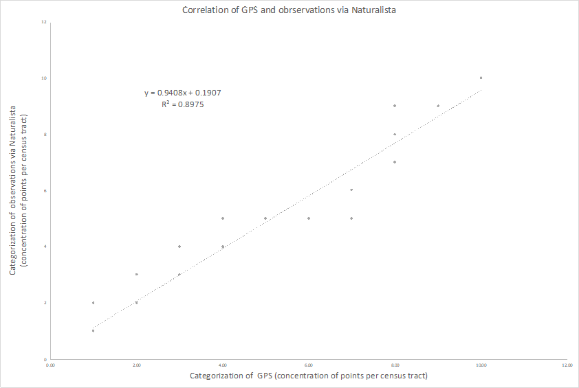
The analysis of this data also intended to show concentration patterns of observations in specific areas of the city. The different concentrations of Naturalista observations per census tract were categorized into eleven groups using Natural Breaks (Jenks)6 from 1 (representing 0 -3 records) to 11 (representing 1634-4549 records) per census tract. This categorization was used to conduct a simple categorical regression of the observations and green public space (GPS) concentration per census tract. To generate a count of GPS point per census tract, a centroid was calculated for all polygons registered as green public space in data sets provided PAOT.
Results
The concentration of logged trees by PAOT for the arboreal census shows that there are very few trees in CDMX officially documented for management purposes- a total of 20123 for the entire city (Map 2). Moreover, the concentration of trees monitored is very high in the center and northeast of the city. Yet, the marginal areas of the city such as the borough of Iztapalapa, Azcapotzalco, and Iztacalco have received little to none attention on this matter. However, interestingly, other marginalized boroughs such as Gustavo A. Madero concentrate the largest number of trees lodged during the census. The robust monitoring of trees in the borough of Gustavo A. Madero could respond to the fact that the Aragon Forest, the San Juan de Aragon Zoo and the National Tepeyac Park are located in that borough.
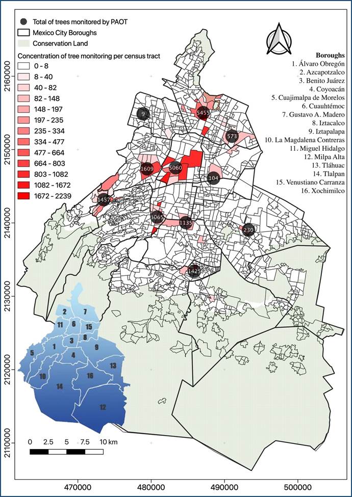
The borough of Iztapalapa located in the south-east area of the city seems to be particularly deficient in terms of institutional monitoring with only 230 trees registered- consider that, as presented in Map 1, this borough has concentrated the largest number of trees from reforestation programs in the past 4 years (a total of 1979 trees, 31% of the total planted during the program). In sharp contrast monitoring has been concentrating on the borough of Cuauhtémoc in the downtown district of Mexico City- a total of 5060 trees were registered in that borough, yet, it only received 524 new trees during the reforestation.
The spatial analysis of observations registered in Naturalista per census tract and the PAOT arboreal census showed similar patterns; in both cases, the East of the city presented a very low concentration of observations and monitoring, respectively (Map 3).Conversely, the south center of the city concentrates most of the activity related to CONABIO’s participatory tool. This pattern could be solely based on the concentration of green public space; people will be much more prone to participate using the application in vegetated areas and discouraged to participate in barren spaces. Such an assumption could only be proved after analyzing the data with a categorical regression model (Fig. 1); the analysis shows that 89% of the variation associated with concentration of observations via Naturalista is predicted by the concentration of GPS. Such a high social response represents a promising resource for participatory governance oriented to adaptive co-management in the particular case of the urban socioecological system of Mexico City. However, this analysis also confirms the steep differences among boroughs in the city in the distribution and also monitoring of trees. In other words, the partial concentration of observations via Naturalista shows that specific marginalized areas of the city remain to be severely underserved of GPS while the recently reforested areas receive little to no institutional monitoring.
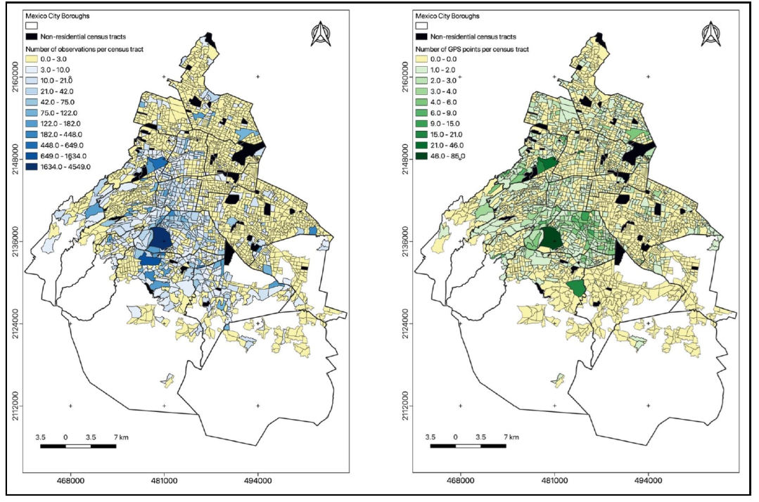
Map 3 Comparison of observations via Naturalista (coded blue) and green public spaces (coded green) concentration per census tract.
Discussion
The institutional efforts of current and past administrations in Mexico City have resulted in the implementation of progressive policies and programs to modernize urban forestry; adaptive co-management is an illustrative example. However, based on PAOT’s monitoring data, the efforts of monitoring urban trees are quite scant and, considering recent reforestation sites, misplaced. Moreover, the distribution of monitored sites presents a pattern biased against the marginalized areas of the city. Iztapalapa, Iztacalco, Gustavo A. Madero and Azcapotzalco, all boroughs with high levels of marginalization and the lowest number of green public space m2 per habitant, also registered a very low number of observations; this results support the environmental justice postulation that GPS and services related to its management are often biased against poor people (e.g. Bolin, 2013; Boone et al., 2009; Perkins, Heynen, & Wilson, 2004). In Mexico City, marginalized areas are underserved of trees and lack proper supervision of reforested sites. Furthermore, the high levels of institutional monitoring in the borough of Cuauhtémoc can also be explained because of the concentration of historical green public spaces in the area such as the Alameda Central Park, and the main (forested) avenue of Mexico City, Reforma. This area of the city also has a very high touristic value, important architectural landmarks and the old neighborhood of Condesa are located in this borough. In a sense, trees have been part of the face of Mexico City to tourists since the city was originally built, hence, monitoring this “public to the world areas” has always been a priority (Wakild, 2007). This lack of appropriate monitoring of reforestation projects by decentralized organizations could indicate that the Adaptive Co-Management (ACM) framework or its operationalization is not yielding productive results. Further research on institutionalized monitoring programs for urban trees in the city should provide additional information on trends through time; however, current data indicates that there is a deficit of tree monitoring in general and particularly accentuated in marginalized areas of the city. In this context, adaptive co-governance and other forms of participatory governance seem to be promising approaches for citizens to start addressing the lack of monitoring pressing issues Fung (2015) such as distribution of trees in all areas of the city.
Representative samplings of Mexico City’s urban forest have been conducted since the decade of the 1990s (Chacalo, Aldama, & Grabinsky, 1994; Meza, 1992), however, the majority of studies have been centered on green public spaces and vegetation cover in relation to distribution, ecological and socio-demographic characteristics, management and planning (Checa-Artasu, 2016; Flores Xolocotz & González-Guillén, 2012; Flores Xolocotzi, González-Guillén, & de los Santos-Posadas, 2010; Meza Aguilar, 2015; Robles, 2014). The urban forests of Mexico City has been studied with a wide variety of approaches and methodological tools but inventories of Mexico City’s trees are scant relative to modern analysis technics using remote sensing tools and images collected via satellites. In addition, until Naturalista was available for the citizens, the collection data regarding trees (tree inventory) were exclusively conducted by PAOT. The data provided by Naturalista provides a new approach to monitor and analyze our urban forest and it should be explored further.
Interestingly enough, while comparing the efforts of reforestations in large cities of the world, the figures of Mexico City are significantly low. For example, Yao et al. (2019) reported that in the city of Beijing, China, the reforestation strategy by the government involved 50 million new urban trees. Another example can be found in New York City, USA; McPhearson et al. (2017) reported that the reforestation project for the American city was of at least 1 million new urban trees only for the year of 2016. In Mexico City, a two-year reforestation program accounted for less than 10,000 new urban trees. The disparities are considerable and further studies should investigate the reasons why there is no more investment in the reforestation of Mexico City.
The current distribution of reforestation sites, monitoring and civic participation in marginalized boroughs is a clear pattern in Mexico City borough of Iztapalapa is particularly low even though presented the highest number of trees planted during the period analyzed; however, it also presented the lowest concentration of both institutional and civic monitoring.
The inequitable distribution of reforestation sites, monitoring levels and civic participation in the 16 boroughs of Mexico City may be explained as a failure in the institutional arrangements guiding the arboreal census in the city. The PAOT, responsible for monitoring urban reforestation programs, is already capable to collect and process large amounts of data related to urban trees; this fact reveals that adaptive co-management is productive. However, PAOT’s work should be conducted using equity guidelines to avoid over-monitoring and to assure the punctual assessment of recently reforested areas.
Furthermore, the Naturalista software proved to be a promising participatory tool useful to collect data while enabling citizens to be directly involved with the management of the urban forest. Urban forestry has been greatly beneficiated from citizens’ science programs and participatory tools (Su, 2019; Wolf & Kruger, 2010). Considering the current availability of technology devised to engage people in science and management, involving citizens further should be an objective to be pursued by governments in Mexico City and other large cities of the country.
It is essential to call attention to the fact that social and cultural aspects of trees such (e.g. perceived purpose, use regularity, aesthetic value, cultural value, etc.) are not included in PAOT’s arboreal census. Based on the urban forestry literature, for the adequate management of CDMX’s urban forest, it is necessary to account for as much as possible of its socio-ecological dimensions. The current arboreal census should be complemented with a section that further explores the relation of Mexico City residents and their urban trees.
Conclusions
A spatial and statistical analysis of the distribution of trees monitored by PAOT was presented to scrutinize the Reforestation Program of Mexico City (2016-2018) in the context of adaptive co-management (ACM). The analysis indicated that the number of urban trees monitored is very low and inequitably distributed in the city. Boroughs like Iztapalapa, recipient of 31% of the total new trees planted during the period studied, received significantly less monitoring activity compared with other boroughs of the city. In the case of the Mexican capital, ACM was implemented for environmental management, specifically for the urban forest, using the participatory tool of Naturalista operated by CONABIO. The tool demonstrated to have much potential in the operationalization of inclusive reforestation programs considering that, for example, theNaturalistaplatform collected information from 26637 trees whereas the PAOT was capable to register information from 20122 trees. Data showed that citizens' participation in monitoring the urban environment has been increasing and could represent an important source of information useful to generate adequate urban forestry practices.

