


 nueva página del texto (beta)
 Inglés (pdf)
 Artículo en XML
 Referencias del artículo
 Enviar artículo por email
 Citado por SciELO
  Similares en
SciELO
Similares en
SciELO 
 Permalink
Introduction
The drivers of deforestation worldwide are broad and complex, and involve many institutional, technological, socioeconomic and demographic factors (Hobbs, 1993; Lee, Carr and Lankerani, 1995; Collinge, 1996; Ghosh, 2004; Tabarelli, Cardoso da Silva and Gascon, 2004). Locally, some practices that have contributed to the loss of the world’s forests are itinerant agriculture, slash-and-burn agriculture, opening of clearings to colonize forested areas, illegal logging, man-made forest fires (that have contributed to net forest losses in temperate and tropical forests alike) and other modifications to land use (Consejo Civil Mexicano para la Silvicultura Sostenible [CCMSS], 2009).
Understanding the dynamics of land use and land cover is the key to address problems and changes at any scale (Geist and Lambin, 2001). Land use, land cover and forestry investigations (LULCF) evaluate these landscape transformations and enable researchers to identify its causes and consequences, and represent a valued tool for users of these forests and for planners of public policies concerned with land use. LULCF studies can generate forecasts and project future scenarios in both the natural and the social environment, and help to estimate economic outcomes (Ellis and Pontius, 2007).
The country-scale panorama is dire. Mexico has lost most of its tropical lowland and mid-elevation temperate forests. This loss continues to advance at a rate close to 1.1% per year (Organisation for Economic Co-operation and Development [OECD], 2003; Food and Agriculture Organization of the United Nations [FAO], 2016), and strategies focused on conserving the remaining fragments and restoring degraded forests are needed. According to Lambin (1997), quantitative reference data to guide where, when, how much, and why landscape modifications occur, are key to the success of forest management but very often incomplete.
Studies of land use change in Mexico are a key priority because it is one of the countries with the highest deforestation rates (Bocco, Mendoza and Masera, 2001). The country lost 720 000 ha of forests and semi-arid vegetation per year during the nineties, the period in which we initiated this study. Patterns of deforestation differ by region, and almost 80% of it occur in the central and southern portions of this country (Masera, 1996). It is important to highlight that forest degradation, the loss of structural elements of forests, and decays in the quality of ecosystem services are serious processes whose extent is currently unknown but that can be added to the problem of forest loss.
Land use in Mexico’s state of Veracruz has been historically intense and has resulted in present-day fragmented forest landscapes. The forested surface of the state has been reduced to approximately 18%, while cattle pastures occupy 47%, agriculture 28%, and the remaining area is composed of semi-arid habitats and wetlands (Secretaría de Desarrollo Agropecuario, Rural y Pesca del Estado de Veracruz [Sedarpa] and Comisión Nacional Forestal [Conafor], 2006; Gerez and Pineda-López, 2011). Statistics from most natural protected areas in the state are similar state-level ones.
Objetives
The purpose of this work was to present an analysis of land use and land cover at two different scales inside a national park and to describe its trends over a decade (1995-2004).
The meso-scale analysis took place at the Parque Nacional Cofre de Perote (PNCP), one of Mexico’s oldest national parks, and at a micro-scale at the ejido1 El Conejo, a titled community nested inside the boundaries of the PNCP. Given the trends detected at both scales, the probability of change in land cover was estimated and related to land tenure; also, forecasts of future scenarios for all land cover categories are presented. In the end of the study, specific recommendations for the management of the park and for augmenting its forest area are presented.
Materials and methods
The study is focused on two scales, a ‘meso-scale’ ( > 104 ha) and ‘micro-scale’ ( < 103 ha), with a difference of about one order of magnitude.
The meso-scale: land use and land cover at the Parque Nacional Cofre de Perote
Decreed in 1937, the PNCP has an area of approximately 11 700 ha. It was established with the aim of protecting conifer forests (importantly sacred fir, Abies religiosa) around the highest peak of a volcano (Fig. 1). Different land use and vegetation type categories were identified based on an analysis of digital orthophotos at a 1:20 000 scale at two different points in time, 1995 and 2004. For latitude, orthophoto line E and for longitude zone 14 were used in quadrants E14B26, E14B27, E14B36 and E14B37 of federal government coverage (Instituto Nacional de Estadística, Geografía e Informática [Inegi], 1995a, 2004 a). This resolution was elected because it offers optimal results at this and lower grain resolutions (González and Marey, 2009).

Figure 1 Land use and land cover at Mexico´s Parque Nacional Cofre de Perote and the ejido El Conejo, 2004.
The classifications of land use and vegetation are based on size, shape, shading, tone and texture of the objects in these images (Graham and Read, 1990) and are organized in the following categories based on ground-truthing: forest, agriculture, human settlements, open woodlands, open woodlands with agriculture, open woodlands with montane grassland, montane grassland (zacatonal), water body and without vegetation.
Ground-truthing of features observed in orthophotos were made by plotting 1-ha parcels throughout the study area using ArcInfo’s extension ‘Repeating Shapes’ and placing them in randomly selected points totaling 10% of the PNCP area using the extension ‘Random Point Generator v. 1.1’ (Environmental Systems Research Institute, Inc. [ESRI], 1999). For ground truthing, in 2004 the centroid of each plot was visited by foot using a GPS.
Cartography
The field-verified land use and vegetation maps were assembled in a geographic information system built specifically for the PNCP using ArcView’s ArcMap 9.2 (Esri, 1999) and the data layers were combined with coverage publicly available from the Comisión Nacional para el Conocimiento y Uso de la Biodiversidad (Conabio, 2010) such as access roads, urban and rural localities.
Data analysis
Change in land use and land cover between 1995-2004 was done by crossing overlapping attribute tables using ArcMap’s ‘Union’ function. Maps, data tables and a transition table were generated using the ‘Dynamic Tables’ in Excel v. 12.3.6 (Microsoft Corporation, 2008), and the net land use change was determined by land use and vegetation type.
The data table resulting from this analysis was used to estimate the relative transition probability (the probability that a land use category changes to a different one, expressed in percentage), based on the typology proposed by González and Marey (2009) with slight modifications for this study.
The micro-scale: change in land use at ejido El Conejo
This settlement was founded in 1897 as a sawmill town and formally established as an ejido in 1934, three years before the national park. El Conejo (768 ha) is the only ejido completely nested inside the PNCP, and it represents the conflict of dual land tenure typical of most protected areas in Mexico. Families have individual agriculture or cattle-raising plots that cannot be sold or given away-but can be inherited by their children-and large portions of the titled land remain in control of the general assembly that determines temporary or permanent uses. Since 1994, ejidos have been formally allowed to become private property, but large portions of Mexico, particularly in the south, still remain organized as such. A buffer of 200 m was added to the perimeter of the study area in El Conejo, since the activities of its people also take place there, and document the results of a total of 1046 ha (Fig. 1).
Interpretation of orthophotos to determine vegetation and land use
Digital orthophotos were used at a scale of 1:75 000, pixel size 2 m2; line E14B26E (UTM projection, Spheroid GRS 80, zone 14, datum ITRF92 in meters, March 1995) to determine vegetation type and land use (Inegi, 1995b).
Polygons were plotted to differentiate land cover categories and digitized them directly on the screen from the orthophoto background. Polygons were digitized at a 1:10 000 scale to diminish estimation errors (representation of true scale is 1:15 000). The minimum area size that was able to plot was approximately 3 mm × 3 mm, which means that only areas 900 m2 and larger are included in this map. Polygons were named or labeled by dominating land cover type, for example, a polygon labeled as ‘Agriculture’ had to contain more than 95% of its area with agricultural fields. Some features, such as areas with isolated trees that covered an area of 10% or less, were included in the category that dominated the remaining area. Some polygons that are labeled in mixed categories, such as ‘open woodlands with vegetation’ had to have between 60%-90% of its total area with the mix of agriculture and woodlands covering most of the polygons.
To generate the vegetation and land cover map for 2004, Inegi’s (2004b) digital orthophotos were used at a 1:40 000 scale and a pixel size of 1 m2 (lines E14B26E3, E14B26E4, November 2004). The same steps were followed to generate both the 1995 and the 2004 maps.
Change in land use and vegetation
At both scales, the changes between 1995 and 2004 were estimated by a simple comparison of the data from both periods. Both maps were converted to a 1:15 000 scale and compared to other layers such as hydrology, roads, etc., of the 1:50 000 topographic map E14B26 for Perote. The standards and specifications set forth were followed by the Norma Oficial Mexicana NOM-023-RECNAT-2001, Mexico’s national standard to produce official inventories of land use at scales 1:20 000 and higher (Diario Oficial de la Federación, 2001). This national standard in turn follows the conventions of other countries such as the Netherlands and the United States. Also, ArcView 3.2 was used to process these maps (Esri, 1999).
The probability of change was estimated using a transition matrix model (McAuliffe, 1988):

Where A is the transition between land use categories, and a ij is the probability of change of category i for category j over time. The transition probabilities were calculated using the following equation:
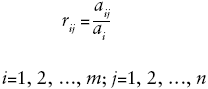
Where r ij is the probability of transition from category i to category j over time.
Although land cover and land use categories roughly correspond at both scales, the resolution of source data at both scales is different, so the categorization at both scales is not identical.
Results
Land use and land cover at the PNCP 1995-2004
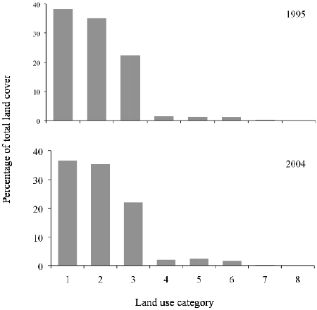
The first result is that the PNCP total area is 11 530.70 ha, nearly 170 ha smaller than reported in official data. In 1995, the four most important land use categories (comprising 94% of the area of this national park) were agriculture, open woodland, open woodland with montane grassland and forest. By 2005, the four most important categories were agriculture, open woodland, forest, and montane grassland, totaling 89.9% of the total area (Fig. 2).

Land use categories are: (1) agriculture, (2) open woodland, (3) open woodland with montane grassland, (4) forest, (5) without vegetation, (6) montane grassland, (7) open woodland with agriculture, (8) human settlement and (9) water body
Figure 2 Land cover of the Parque Nacional Cofre de Perote 1995-2004.
The most striking difference during this period was the change in open woodlands, which had a decadal loss of more than 80% of its initial area. In turn, the most remarkable increase was in montane grasslands, which had a nearly 10-fold increase in one decade (these two changes correspond almost to the hectare with one another). Two other land use categories that had significant proportional changes (although small in total area, as none of them is over 160 ha) are open woodlands with agriculture and water bodies that increased about 1.3 times from its original cover.
The breakdown of gains and losses by categories, and the proportion of the total area that had no change are of great interest. Below the changes by category are shown (ranked by total area, from largest to smallest; Table 1). Most categories of land use remained relatively constant and the total areas and proportion of the total land cover had very few changes (Fig. 2).
Table 1 Land cover change by land use category (per hectare, ranked by total area) at the Parque Nacional Cofre de Perote, Mexico, 1995-2004.

Agriculture
The majority of the area with this land use category remained unchanged. Agricultural areas were transformed into open woodland with agriculture, open woodland and forest.
Open woodlands
Like agriculture, most of this land use remained unchanged and kept its initial use. The small area that was transformed into other categories transitioned into forest, and very small areas changed into open woodland with montane grasslands, agriculture, montane grasslands and open woodlands with agriculture.
Open woodlands with montane grasslands
With the largest loss in total area, this land use was reduced to less than a sixth of its original cover. The majority of this area was transformed into montane grasslands.
Forest
This land use category had a small net gain. Although the small variation in total area seems to indicate this land use category had few changes, about a third of the initial area covered by forest shifted to another land use. The gains in forest area offset this forest loss come from successional progressions of open woodlands, open woodlands with montane grasslands and agriculture, which became forests during this decade.
Without vegetation
Areas that were devoid of vegetation in 1995 remained without it during the whole decade of this study. Areas without vegetation were formerly areas covered by open forest and agriculture.
Montane grasslands
This land use had the most striking gain in area, an almost ten-fold increase. It took over open woodland with montane grassland and open woodland. Eliminating sparsely distributed trees in the former land use is possibly the easiest land use transformation in this landscape.
Open woodland with agriculture
This land use more than doubled its initial cover. About a quarter of the area in the open woodland with agriculture class remained in this class. Gains in this class resulted from conversion from the open woodlands with montane grasslands class.
Water bodies
Water bodies more than doubled its area in the decade of this study, taking over areas of woodland and montane grassland.
The probability of land use change (r ij) at the PNCP in the 1995-2004 decade is estimated in table 2. The three land use categories that had the highest probability of keeping the same land use over the ten years of this study are agriculture, open woodland with montane grassland and open woodland, the three most abundant categories that make up three quarters of the total area. In contrast, the most dynamic land use transformation probabilities are montane grasslands to open woodland with montane grasslands, open woodland with agriculture to agriculture, and forest to open woodland. The mean probability of land use categories keeping their current cover is 0.67 (SD = 0.37, n = 8), whereas the mean probability of land use categories changing to a different cover is 0.04 (SD = 0.14, n = 56).

Land use and land cover at ejido El Conejo 1995-2004
Over 95% of ejido El Conejo is dominated by three land uses: agriculture (potato plantations), forest (dominated by sacred fir), and open woodland with agriculture. This ejido has a surprisingly static pattern of land use since its foundation: except for agriculture, the two major land use categories remained the same in the decadal period 1995-2004. The largest percentage change was recorded in one of the minor land use categories (shrubland) that actually represents less than 2% of the ejido area. Shrubland, one of the original vegetation types of the region dominated by the shrub Baccharis conferta, had actual area gains (Table 3).
Table 3. Land cover change by land use category (in hectares, ranked by total area) at ejido El Conejo, PNCP, 1995-2004.

Agriculture
The area dedicated to agriculture had a modest decrease over the decade of our study. Although agriculture has been, along with forestry, one of the two main activities of its people and it is striking that it hasn’t gained additional area.
Forest
This land use had a negligible increase in area, less than 1%, during the decade of this study. The forest remaining in the area is composed of patches of sacred fir, although this species is also present in the shrubland areas.
Human settlement
This land cover increased by almost a third. Although modest in net area, this is also one of the most important changes recorded in the ejido.
Shrubland
With the largest gain in total area, the advance of shrublands represents the progression of secondary succession in areas dedicated to other land uses.
Shrubland with montane grassland
The small area dedicated to this land use at the beginning of this study was completely gone in 2004.
Without vegetation
The small patch of land with no vegetation recorded in 1995 essentially disappeared a decade later.
The probabilities of change (r ij) of the seven land cover categories at El Conejo are shown in table 4. The mean probability of the different land cover categories keeping their current land use at the ejido is 0.69 (SD = 0.38, n = 7), essentially the same documented for the PNCP as a whole, whereas the mean probability of change to a different land use is 0.03 (SD = 0.15, n = 42), also in concordance with the one recorded for the broader national park.

Discussion
Land cover and land use trends
The decadal dynamics of land cover and land use for the PNCP and El Conejo are very similar. At the larger, meso-scale, the most significant changes were the loss of a substantial amount of open woodlands and its replacement with montane grasslands. The shifts from one land use to another provide key information into the main drivers of habitat losses and gains-for the PNCP, the main finding is the slow process of degradation of forests that are turned into woodlands and then into montane grasslands-. Cattle raising and agriculture are the two that stand out.
At the micro-scale, the ejido had no abrupt changes of substantial areas (Fig. 3), and the probability of change matrices at both scales have very similar trends as well (Tables 1 and 3). The method for estimating land cover and land use through the analysis of digital orthophotos, originally devised by González and Marey (2009), was successfully used in this case study.
The protected area of the PNCP has been severely affected by human activities like agriculture and cattle raising. Although most of the loss of natural land cover at the PNCP happened in a period much before the decade of this study, a large proportion of it happened after it became protected (García Romero, Montoya, Ibarra and Garza, 2010). This is by no means a situation exclusive of the PNCP: when comparing our statistics with those of other national parks such as the PN Pico de Tancítaro in the state of Michoacán (Sánchez, Bocco, Fuentes and Velázquez, 2003), a similar trend of loss of open woodlands and forests can be found.
The role of the PNCP protecting sacred fir forests
Vegetation type-wise, sacred fir forests in Mexico face a similar fate in many protected areas containing it. Sacred fir is widespread and it is the second land cover category in the study (Comisión Nacional de Áreas Protegidas [Conanp], 2011). Abies religiosa forests are present contiguously in temperate sub-humid areas of the Central Volcanic Belt, where the PNCP is located (Sánchez-González et al., 2005). Although this forest type is legally protected in five national parks, it faces serious problems inside all of these areas: illegal logging, loss and degradation of its functionality due to increases in agriculture, livestock grazing (bovines and sheep), human settlements and other causes.
What the meso and micro-scale trends tell us about effectiveness of management
At the ejido, micro-scale, the management practices and dynamics of land use reflect those of the national park, meaning that its people can take good care of the protection of resources therein. This ejido, located inside the national park, also reflects a situation ubiquitous of Mexican national parks: the conflict of land tenure rights (in this case, for example, the establishment of the ejido precedes the declaration of the national park).
This situation can be turned into an opportunity. The ejido has a strong potential for being an ally of the national park for the management, and Mexico is internationally recognized for its work in community management of natural resources inside temperate zone national parks as well as sacred fir forests (Bray and Merino-Pérez, 2003, 2004; Bray, Durán-Medina, Merino-Pérez, Torres and Velázquez, 2007; Bray, Merino-Pérez and Barry, 2007; Madrid, Núñez, Quiroz and Rodríguez, 2009).
One key premise of these management models is that they are based on social organizations (Durán-Medina, Mas and Velázquez, 2007). In this case, it is possible to implement the management and recovery of the sacred fir forests through the strengthening of the existing social organization of El Conejo. Many initiatives focused on protecting and managing forests have failed for its excessive focus on enforcing tools that ignore the role of communities within or surrounding parks (Hansen, Spies, Swanson and Omán, 1991; Velásquez, Bocco and Torres, 2001; Bray et al., 2007b; Madrid et al., 2009; Larson et al., 2010).
Management of national parks in Mexico when ejidos are present within their boundaries
Ejidos and communities established within parks face difficulties in taking on management initiatives. For example, it is illegal for them to work on management plans for their natural resources because they are located inside a park. However, in practice, they actively use these forests without a plan and slowly degrade its forests through small-impact actions such as selective timber extraction and “ocoteo” (the subtraction of resin-saturated wood from the core of conifer trees without cutting the tree itself, a common resource for starting kitchen fireplaces).
National authorities are aware of conflicts like these, and the Conanp, the federal government agency in charge of managing national parks, recently issued an evaluation document defining the issues, objectives and strategies to improve the conservation of natural protected areas in the country, analyzing the effectiveness and impacts of its public policies (Conanp, undated).
These policies make no distinction of natural protected area categories and establish benchmarks to evaluate its success, many of them related to land tenure and gaining additional areas for conservation. Conanp’s focus on land tenure, however, doesn’t address the problem of clarifying and defining the relationship of people with legal land rights inhabiting protected areas.
This is a critical issue, because it does not recognize the rights of people legally inhabiting parks nor recognizes them as fundamental actors in its management and conservation. At the local scale, it is of core importance that the PNCP addresses this issue by incorporating social organizations from ejido El Conejo-and the people of all 13 localities of four municipalities related to the park-into the management plans for this park.
Conclusions
Comparing the dynamics of land use at two different scales allowed this study to demonstrate the effectiveness of two management approaches and its effects in land use stability in this national park. In the decade of the study, the ejido management practices stabilized the dynamics of land use more effectively than those of the authorities charged with the protection of the park. This case study supports a growing body of evidence that shows that, given certain conditions, people living in protected areas can be effective stewards of its resources.
The results of the analysis allows to make a broader statement about the role of communities living inside national parks. For the state of Veracruz-and for Mexico’s park system as a whole-the PNCP is an important natural protected area. Its protection requires rethinking its conservation strategies and management tools. This national park, like many other protected areas in the country, harbors important human settlements whose needs should to be integrated into the conservation vision of the park-that could guarantee the long-term stability of land cover and land use.
The PNCP, as well as five other national parks in the country, is essential for the protection of Mexico’s Sacred fir forests. This vegetation type’s restricted distribution has diminished its area to diverse set of causes, such as illegal logging, cattle ranching, new human settlements, etc.
The process of natural secondary succession from shrubland to forest could be used to increase forest cover. Gains in vegetation cover can help recover the ecological function, Carbon storage and other services associated with forests in good condition.

