


 text new page (beta)
 English (pdf)
 Article in xml format
 Article references
 Send this article by e-mail
 Cited by SciELO
  Similars in
SciELO
Similars in
SciELO 
 Permalink
INTRODUCTION
After the 1912 Acambay earthquake, various studies have been performed in order to identify and characterize the seismogenic fault of this graben (e.g., Urbina and Camacho, 1913; Mooser, 1972; Martínez-Reyes and Nieto-Samaniego, 1990; Suter et al., 1992, 1996, 2001). Since the beginning of the 21st century, various paleoseismological studies have also been carried out in order to evaluate the seismic hazard (Langridge et al., 2000; 2013; Lacan et al., 2013a, 2013b, 2018; Sunye-Puchol et al., 2015; Ortuño et al., 2015, 2018; Velázquez-Bucio and Garduño-Monroy, 2018). In spite of numerous geological studies performed on the Acambay graben to map and study the active faults and volcanic edifices of this region, none was realized so far for imaging structures at depth. Such studies are however necessary to constrain the geometry of the faults at depth and their relations. These parameters are yet determinant to calculate the seismogenic potential of the faults and their cumulative displacement. Moreover, such study could give information about thermal anomalies under the graben related to geothermal circulation and Holocene volcanism. In this paper, we present the first results of an integrated geophysical study using magnetotelluric (MT) soundings, as well as gravity and aeromagnetic data aiming to characterize the deep structure of the Acambay graben.
GEOLOGICAL SETTING
The Acambay graben is located in the central sector of the Trans-Mexican Volcanic Belt (TMVB) at the intersection between the SSE-NNW Taxco-San Miguel Allende and the E-W Chapala-Tula faults systems (Figure 1). The Taxco-San Miguel Allende fault system was active from Oligocene to early Pleistocene times (Alaniz-Álvarez et al., 2002). It corresponds to a crustal step between the 50 km thick crust to the east and the 40 km thick crust to the west (Ferrari et al., 2012).
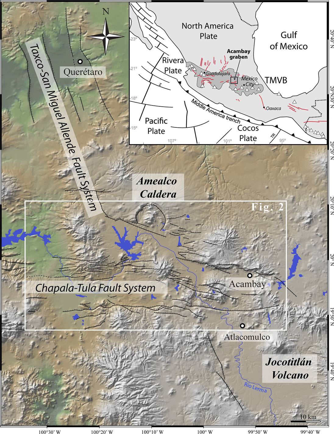
Figure 1 Geomorpho-structural map of the Acambay graben intersecting the Taxco-San Miguel Allende fault system. Inset shows the location of the study area in the Trans-Mexican Volcanic Belt (TMVB). TR: Tehuantepec ridge.
The morphological traces of the main faults are well preserved to the north and to the south of the Acambay graben and coincide with numerous hydrothermal sources. In the Acambay graben, the morphological imprint of this fault system was erased by the subsequent activity of the Chapala-Tula fault system but its persistence at depth was revealed by magnetic and gravity anomaly data (De la Fuente and Verma, 1994). The Chapala-Tula fault system is regarded as an active system along the nearly 400 km of extension of aligned faults. Its central part, the Morelia-Acambay fault system, draws a ~30 km wide fault belt where WSW-ENE to E-W extensional structures formed tectonic basins (Ferrari et al., 1990; Martínez-Reyes and Nieto-Samaniego, 1990; Pasquarè et al., 1991), being the Acambay graben the easternmost of these basins.
The Acambay graben is an almost east-west striking structure, limited by the Pastores and Venta de Bravo faults to the south, and by the Acambay-Tixmadejé and Epitacio Huerta faults to the north (Figure 2). The graben can be divided into two sub-units. To the west, the graben is wider and 30 km separates the 50 km long Venta de Bravo and 32 km long Epitacio Huerta faults. To the east, the graben is the narrowest and just 13 km separates the 43 km long Acambay-Tixmadejé and the 33 km long Pastores faults (Figure 1). On both of these sub-units, inside of the depression, the E-W striking central graben fault system cuts across the graben filling over a distance of 70 km (Figure 1; Martínez-Reyes and Nieto-Samaniego, 1990; Johnson and Harrison 1990; Suter et al., 1992, 1995).
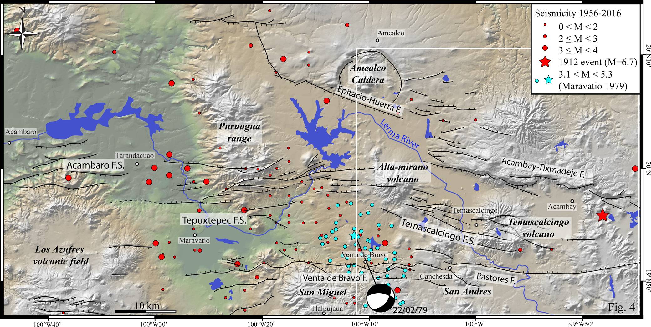
Figure 2 Sismotectonic map of the Acambay graben showing active faults and major volcanic edifices. Modified from Lacan et al. (2018).
Since the beginning of its opening during Miocene time, the Acambay graben has been filled by a series of volcanic deposits and fluvial-lacustrine sediments that in some places are overlapped by volcanic edifices and lava flows. The 1912 Mw 6.9 Acambay earthquake, associated with surface ruptures along Acambay-Tixmadejé, Pastores and Temascalcingo fault systems, highlighted the Holocene activity of the northern border of the graben. This persistent tectonic activity has been then demonstrated for most of the graben faults by different paleoseismological studies (Langridge et al., 2000; 2013; Lacan et al., 2013a, 2013b, 2018; Ortuño et al., 2015; Sunye-Puchol et al., 2015). The relation between tectonic activity and volcanism is not clear within the graben. Some volcanic edifices appear to be aligned along active faults but are also cut by the faults. This could indicate a contemporaneity between tectonic activity and volcanism that could persist into the Holocene as indicated by the volcanic deposits encountered in paleoseismological trenches (Aguirre-Díaz et al., 2015).
MAGNETIC DISTRIBUTION AND FAULT STRUCTURES ALONG THE ACAMBAY GRABEN
High quality aeromagnetic data covering the country at scale 1:50,000 have been readily available in Mexico for more than two decades. Although this scale may not be convenient for detailed prospection purposes, it is quite useful to assess the structure of large tectonic features such as the Acambay graben. Figure 3a shows the Residual of the Total Magnetic Field (RTMF) anomaly chart of the Acambay graben area, obtained from the combination of the processed digital aeromagnetic charts E14 and F14 (https://www.gob.mx/sgm). The magnetic data were acquired by the Consejo de Recursos Minerales (CRM), now Servicio Geológico Mexicano (SGM), using a high sensitivity (>0.01 nT) Cesium magnetometer at a constant height of 300 m above terrain topography and have been corrected for diurnal variations and referenced to the IGRF (e.g., Lowrie, 2007). Blue tones in the figure represent low magnetization zones whereas red tones characterize high magnitudes of magnetization, yellow-green colors are inflexion zones where the horizontal gradients reach maximum values. For comparison we have included the main fault traces (black lines), the course of the Lerma River (blue line), and volcanic edifices (red triangles) in the figure (Lacan et al., 2013a). The thick dashed line in the right side of the figure represents the trace of coincident MT and ground gravity profiles, and the thinner dashed line shows the trace of the western ground gravity profile. We applied the reduction to pole and horizontal gradients procedures to the data, and estimated the tilt magnetic chart (Miller and Singh, 1994); however, the later fitted better the surface faults. Figure 3b shows the tilt of the RTMF, which emphasizes lateral variations in magnetization through the ratio between the vertical and total horizontal field gradients (Verduzco et al., 2004). The eastern side of this chart shows nearly E-W lineaments, whereas the western side shows a less obvious trending pattern. Mapped fault traces are only partly coincident with maxima or minima of the RTMF or tilt alignments, indicating that fault traces on surface not always are represented by a magnetic alignment response.

Figure 3 a) Residual of the total magnetic field (RTMF) chart of the Acambay graben; b) Tilt chart of the RTMF for the same area. Fault traces are from Lacan et al. (2013a), triangles represent volcanic edifices, stars cities and towns, pale blue line across the graben represents the Lerma river, the thin dashed line is a ground gravity profile and the thick dashed line is the interpreted magnetotelluric, and coincident gravity and magnetic profiles. TDR: Tilt Derivative of the RTMF; Vertical Derivative of the RTMF; THDR: Total Horizontal Derivative of the RTMF.
However, the Pastores fault trace appears to be closely related to the elongated magnetic anomaly observed in the southeastern sector of the Acambay graben. Elsewhere in the graben area, the spatial relation between the main faults and the magnetic alignments observed is not obvious. Indeed, the magnetic signature is portraying a complex graben structure at depth where volcanic edifices play an important role in the distribution of magnetized ground. Furthermore, not only ferromagnetic minerals dispersed within the host rocks matrix of the volcanoes surroundings account for the observed high magnetic anomalies as large as 400 nT, but also trapped differentiated ensambles of magnetic minerals above the Curie point from nearby volcanic centers may contribute importantly to the surface magnetic signature (Arzate et al., 2017).
THE MAGNETOTELLURIC DATA SET AND GRAVITY PROFILES
The magnetotelluric survey comprised the measurement of 13 magnetotelluric (MT) soundings along a 25 km nearly NS transect across the Acambay graben, as well as of 12 time-domain (TDEM) single loop shallow soundings used to correct the MT resistivity data for static shift. We also collected data at a total of 83 gravity stations along two nearly parallel profiles, one of which is coincident with the MT resistivity transect. Figure 4 shows the location of the MT stations, the TDEM sounding sites, and the ground gravity stations.

Figure 4 Location of magnetotelluric (MT) and long period magnetotelluric (LMT) soundings (blue and yellow circles), sites of time-domain electromagnetic (TDEM) soundings (green circles), and gravity stations (red dots) across the Acambay graben. The upper graphs show the total magnetic field (TMF) extracted from the digital magnetic charts (see text) and the terrain corrected interpolated Bouguer Anomaly (ABC) for the western (left) and eastern (right) geophysical profiles across the graben structure.
We used Phoenix MTU-2000 and V8 systems for the MT soundings and terraTem equipment for the complementary TDEM soundings. In addition, four long period magnetotelluric (LMT) stations were installed using four LEMI-417 stations evenly distributed along the profile measuring simultaneously for one week, aimed to improve data quality at longer periods (~100 s). The MT stations registered during periods of 10 to 18 hours. The effective frequency band used for interpretation was 1000 to 0.01 Hz, which represents a maximum investigation depth (skin depth) range between ~100 m and 50 km, assuming a bulk resistivity value of 100 ohm∙m. Investigation depth increases by one order of magnitude at those sites where we used broadband (MT + LMT) soundings. However, we focus on the distribution of the electrical resistivity in the depth range from surface to a maximum of 10 km.
MT and LMT data were processed separately using Phoenix and LEMI´s software respectively. Both processing procedures provided electronic data interchange (EDI) standard format plots that can be easily combined.
The resistivity and phase sounding curves, defined by ρ ij (ω) = (1/ ωµ 0) |Z ij (ω)|2 and φ ij = tan-1 [Im Z ij (ω) /Re Z ij (ω)], respectively, where ω is equal to 2πf, and i, and j are the off-diagonal elements Z xy or Z yx of the impedance tensor, are shown in Figure 5. These static-shift corrected data, measured in a NS-EW reference coordinate system, are the basis of the MT interpretation of the ground in terms of the variations of conductivity with depth. The electric azimuth deduced from the impedance tensor is regarded as a proxy for geological contacts either near-surface or at depth, as penetration depth is frequency dependent. We used Weaver et al. (2000) impedance phase approach to estimate the electric strike φ at the 40 discrete frequencies measured at the 13 MT stations along the profile.
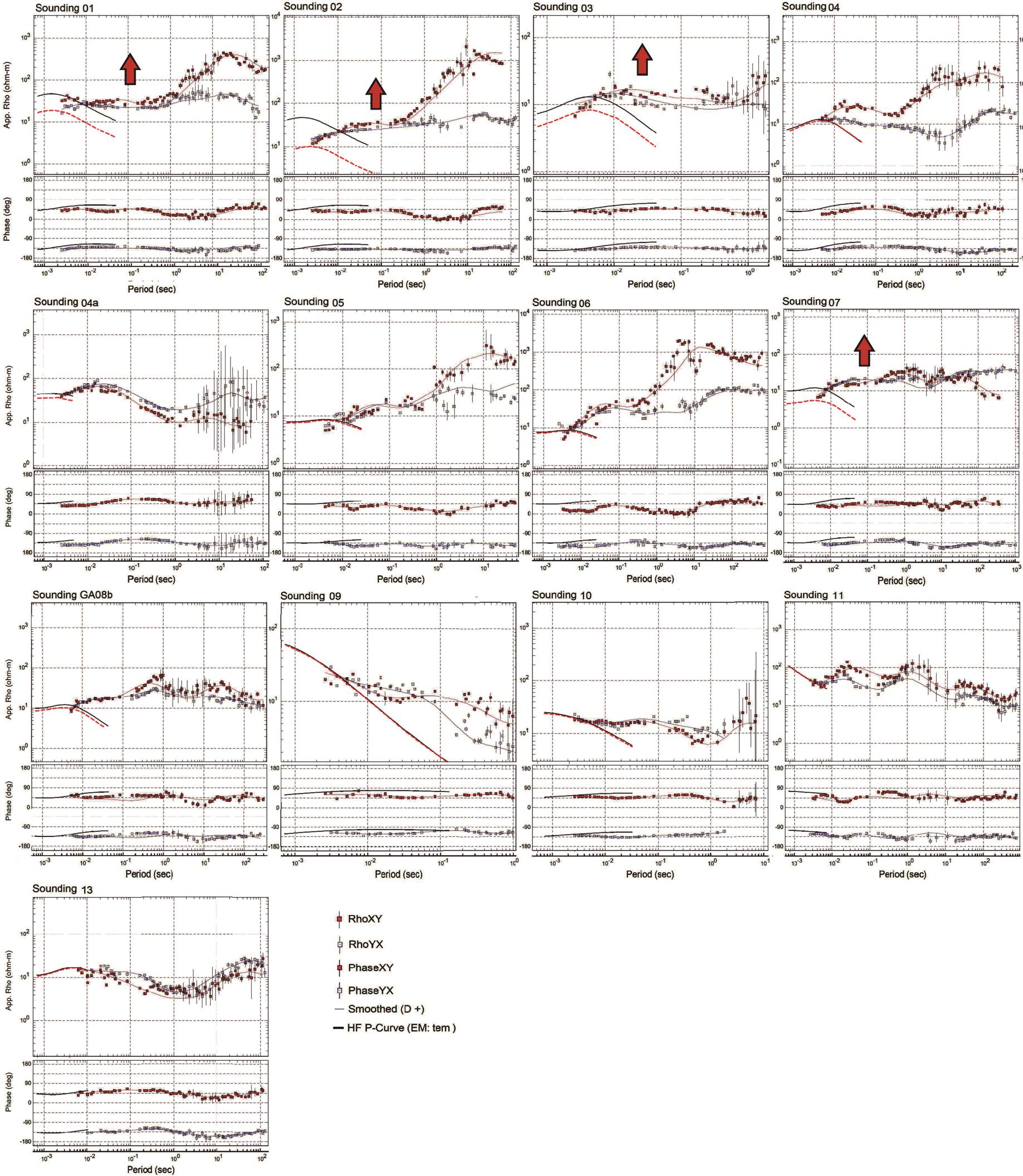
Figure 5 Resistivity and phase curves of the magnetotelluric (MT) soundings. Continuous black lines represent the time-domain electromagnetic (TDEM) sounding curves used to fix static shift on the MT resistivity curves.
The detailed analysis of the electric azimuth φ provides a mean to trace variations of geological structures as a function of depth and position, particularly when structures are good electric conductors or a conductivity contrast prevails across them. Figure 6 shows the electric strike azimuth plotted along the MT profile for three selected period bands: t < 1 s, 1< t < 10 s, and t > 10 s (or equivalent frequency f < 1 Hz, 1 < f < 10 Hz, and f > 10 Hz), corresponding to skin depths of <5 km, between 5 and 15 km and >15 km, respectively, assuming the same bulk ground resistivity of 100 ohm∙m as above. The calculated strike azimuths as function of frequency are indicated with red lines within the white circles for the corresponding MT stations. Electric strike azimuth is somewhat scattered at high frequencies, although at intermediate and lower frequencies appear more consistent with the graben E-W regional fault system, except at some sites due to local distortion.
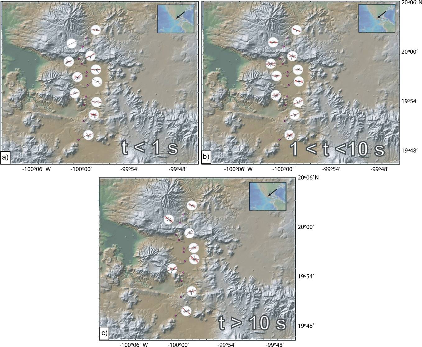
Figure 6 Electric strike (red lines within the circles) and tipper strike and magnitude (black lines within the circles) for the period bands of t < 1 s (a), 1< t < 10 s (b), and t > 10 s (c). Every circle corresponds to a MT station (red dots).
Scattering of electric strike at shallow depths (Figure 6a) may be an indication of two or more fault systems prevailing within the upper 5 km of the crust. At skin depths ranging between 5 and 15 km (Figure 6b), the electric azimuth is more consistent, but differences still prevail between the southern and northern strikes azimuths, yielding more scattered results towards the southern Pastores fault structure. At skin depths below 15 km down to about 50 km (Figure 6c) the electric azimuth is scattered again although some sites within the graben structure still show the influence of the E-W fault system. The average electric azimuth estimated for the full frequency band yields 88.5° ± 10°, which is well consistent with the ~E-W geological strike of the graben structure in the eastern region.
THE MT RESISTIVITY 2D SECTION
We modeled the MT data using the nonlinear conjugate gradient algorithm of Rodi and Mackie (2001) for two-dimensional inversion. The nearly E-W geologic strike of the graben fault system is consistent with the average electric azimuth (88.5°) obtained and used to rotate the impedance tensor. In this reference frame, the transverse electric (TE) and transverse magnetic (TM) polarization modes are defined across and parallel to the graben structure, respectively. Before the simultaneous inversion of the TE and TM modes we tested the grid size and the effect of the smoothness/rugosity parameter τ for values from 0.1 to 10 being completely smoothed at the later. The optimal factor of τ = 0.95 was used for the final inversion with 40 iterations, after which the root mean square (RMS) misfit did not diminished, reaching a minimum RMS misfit equal to 2.15 (Figure 7). The resulting resistivity image along the MT profile down to 35 km depth is shown in Figure 7. High conductivity anomalies (1-50 ohm∙m) are concentrated close to the surface and at the southern end of the profile, suggesting a northward dipping contact at depth (continuous black line) with a relatively resistive (~1000 ohm∙m) regional basement.

Figure 7 Resistivity section obtained from 2D modeling of the magnetotelluric soundings across the graben structure. Red and yellow tones represent the anomalous conductive zones, whereas the magenta and blue tones are associated with resistive lithology. Fault traces (solid lines) were extrapolated from their surface trace to depths suggested by resistivity contrasts between geologic units. The Pastores fault (PF), San Pedro Fault (SPF), San Mateo Fault (SMF), and Acambay-Tixmadejé fault (ATF) converge in the first ~18 km depth. Inverted triangles are the location of the MT stations. In the right graph, the rugosity and root mean square (RMS) misfit values are plotted as a function of parameter tau (τ). A value of τ=1 was used to avoid too rugged or too smoothed results. Dotted lines represent limits of layers with contrasting conductivities.
The southern ~70° dipping contact zone corresponds to the trace of the Pastores fault, whereas the Acambay-Tixmadejé fault, with an estimated dipping angle of nearly 70° as well (thinner southwards dipping black line), appears to occur within the same basal unit. The resistive basement defines two sub basins, one in the northern part of the profile and the other in the central part, of about 1 and 2 km thickness, respectively. Other resistive zones are shown as isolated patches near the surface above ~2 km, which are the responses of near surface volcanic products that are shown dissociated perhaps because of the limited sounding coverage. The conductive-resistive inclined contact parallel to the trace of the Pastores fault is well constrained by most of the MT sites along profile, however the western fault contact is more ambiguous and could have variations to lower values.
DISCUSSION: STRUCTURE OF THE EASTERN ACAMBAY GRABEN
The upper crustal resistivity in the Acambay graben varies from low to intermediate values (200-1000 ohm∙m) in contrast with upper crustal resistivities observed in western and south-western Mexico (Corbo et al., 2013, Arzate et al., 2017), where “normal” crustal values are consistently above several thousand ohm∙m. Furthermore, in the surroundings of Pastores fault and southwards, the crust becomes still less resistive reaching abnormally low values (<200 ohm∙m), perhaps as result of metasomatic processes, actual or ancient. Figure 8 provides a general perspective at a shallower scale of the resistivity structure in comparison with the surface trace of the main fault systems. The spatial distribution of the resistivity suggests that not only the Pastores fault is affected by anomalous conductivities but also the fault system lying inside the graben structure. This interpretation implies a geologic contact of regional character apparently related to the volcanic front of the TMVB and influenced by the southwards dipping fault system.
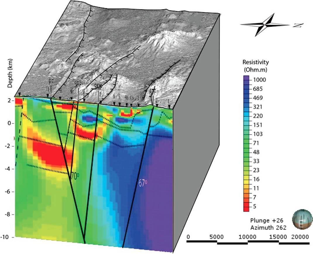
Figure 8 Regional view of the resistivity structure in comparison with the fault systems that conform the Acambay graben. The upper crust in the southern limit of the graben is abnormally conductive. The graben structure in this sector can be regarded symmetric as the estimated angles for the south and north faults are within the measurement errors (~70° and ~67° respectively).
Figure 9a shows the interpreted resistivity section in terms of conductivity changes of the structure in the eastern sector of Acambay graben, constrained with surface geology and confined below surface by the interpolated faults. Both normal faults bounding the graben present a dipping angle close to 70°, converging at a crustal depth of ~18 km (Figure 7), which lie within the seismogenic crustal depth range estimated by Rodríguez-Pérez et al. (2017) for the region (i.e., 15-20 km).

Figure 9 Resistivity section from the simultaneous inversion of the two polarization modes (a) with faults extrapolated from surface locations (continuous black lines) and interpreted contrasting conductivity layering (dashed lines). The synthetized resistivity structure (b) was the base for the 2D density model obtained from the complete Bouguer anomaly using WingLink® software, which is based upon a Talwani et al. (1959) subroutine. The model was constrained with data (density and magnetic susceptibility) from lab measurements of rocks from surface sampling (Felix-Maldonado, 2017). Dashed ellipses in (b) are dipolar bodies necessary to reproduce the residual of the reduced to pole magnetic field. Magnetic susceptibilities contrasts as large as 103 emu are required to reproduce the amplitude of the magnetic anomalies along the profile. These magnetized bodies are correlated with fault traces or stratified contacts (zones marked with parallel lines). At the top of the figure, the enhanced topography profile is shown (e). (c) and (d) show the fitted total magnetic field and Bouger anomalies, respectively. Surface fault traces, correlated with contrasting conductivity alignments at depth, fit the density model and can be reproduced as vertical displacements of the interpreted subsurface lithology. The volcano sedimentary filling of the graben has an estimated maximum thickness of ~2 km.
Since the 1912 Acambay earthquake, the Acambay-Tixmadejé fault, which presented the most important co-seismic displacement, has been considered intuitively as the main fault of the graben. Here we show that the 80 km long Pastores-Venta de Bravo fault system that forms the southern graben border could be the main fault of the graben. In this case, the Acambay-Tixmadejé fault is acting as an antithetic fault. This geometry at depth of the Acambay graben faults could explain why the Acambay earthquake ruptured not only along the Acambay-Tixmadejé fault but also along the Pastores fault and along the central graben fault system. Such geometry is important to evaluate the possibility of multiple fault ruptures in the Acambay graben and the possibility of generating major earthquakes.
Although lateral resolution is limited by the MT sounding density, the vertical ground structure is well constrained by the high number (80) of measured frequencies, which helps to distinguish contrasting conductivity layering (dashed lines in Figure 9a). We used this stratified structure to model the density structure assuming that resistive bodies are denser than the conductive ground and using field samples as reference density values. Densities at increasing depths were adjusted accordingly; however the lack of a regional gravity field in the data suggests that the measured gravity anomaly along the profile is mainly due to the upper 3-4 km.
The gravity and magnetic anomalies (Figures 9d and 9c) have a contrasting behavior across the Acambay-Tixmadejé fault with respect to the Pastores fault system. To the north, the gravity anomaly
(~20 mGal) (Figure 9d) suggests an important vertical displacement at depth across the fault trace, whereas across the southern Pastores fault there is no significant gravity anomaly, which indicates a low lateral density contrast across the fault contact. In contrast, the magnetic anomaly across Pastores fault is quite important (~400 nT peak to peak) whereas its magnitude across the northern fault system is almost insignificant. The dotted red ellipses in Figure 9b represent zones of higher magnetization that together roughly reproduce the residual of the magnetic anomaly. According to these results, magnetized zones in the southern fault system appear to be related to contact zones where resistivity values lie below 200 ohm∙m that can be explained in terms of magnetic metasomatism.
The results suggest different physical conditions at either fault contacts. The northern fault occurs within the same basement unit, which is supported by the resistivity structure and the type of gravity anomaly observed across the fault, while the southern fault come out to be the contact between two equally dense basements units but with different electrical properties across the contact. We speculate that the Pastores fault and the fault system within the graben act as a permeable layer between the southern hydrated-altered basement and the more resistive basement rocks that extent northwards. The observed magnetic high anomaly across the fault enhances the different electrical character of the basements that become polarized close to the fault plane surface and within the graben structure; polarization could be generated by mineralized imprint due to propylitic metasomatism in the surroundings of active or recent volcanism. The presence of nearby Temascalcingo and Jocotitlán volcanoes within and south of the graben, respectively, appear to play a significant role for the conductive ground around the Pastores fault as well as for the observed magnetic signature.
CONCLUSIONS
This geophysical study is the first attempt to image the crustal structure of the Acambay graben. Previously unknown features of the internal structure of the graben where found by the combination of three geophysical methods: magnetotelluric soundings, gravimetry and magnetometry as well as surface geology.
The results provide new insights to understand the geometry and relation between faults affecting this active tectonic region. The geophysical model shows that Acambay-Tixmadejé and Pastores faults have opposite dipping angles of about 70°, defining a nearly symmetric graben structure. The conductive-resistive inclined contact parallel to the trace of the Pastores fault is better constrained by most of the MT sites along profile than the northern fault contact, which is more diffuse and could have variation to lower values. According to the resistivity model, the important conductivity contrast associated to the Pastores fault may indicate that this fault zone is driving the tectonic extensional process in the area. However, further evidence is required to confirm this hypothesis, which may come from additional MT surveying.
According to our results, the Acambay-Tixmadejé fault, as well as the central graben fault system, converges with the Pastores fault within the first ~18 km of the crust, which is consistent with the depth of the seismogenic crustal layer. Such geometry represents an important result for evaluating the possibility of occurrence of earthquakes rupturing along various faults of the graben as observed for the 1912 earthquake. We argue that the connection of faults at depth explains why the surface rupture associated with the 1912 event occurred on several faults despite being separated by about ten kilometers.
The crustal resistivity in the Acambay graben zone exhibits an anomalous conductivity as compared with upper crustal resistivities observed in western and south-western Mexico, where “normal” crustal values are consistently above several thousand ohm∙m. In particular, in the neighbourhood of the Pastores fault and southwards, the crust becomes more conductive reaching abnormally low values (<200 ohm∙m),
perhaps as a result of ongoing metasomatic processes within a hydrated matrix, triggered by the proximity of the Temascalcingo and Jocotitlán volcanoes. The existence of geothermal alteration within the eastern Acambay graben structure is further evidence of the geothermal potential of the zone as an energy source, yet to be prospected.

