


 nova página do texto(beta)
 Inglês (pdf)
 Artigo em XML
 Referências do artigo
 Enviar este artigo por email
 Citado por SciELO
  Similares em
SciELO
Similares em
SciELO 
 Permalink
Introduction
The assessment of pollution impact due to anthropogenic activities usually requires geochemical reference values (e.g.Pan et al., 2017a; Akopyan et al., 2018). Among these activities, mining is known as a source of pollution, which may include mining residues, spills and dam failures, dust emissions (Nordstrom, 2015). This highlights the need of establishing reference values in mining districts to properly evaluate possible environmental disturbances (e.g.Martínez et al., 2007), in soils, sediments, surficial waters, aquifers, dust, etc.
In environmental studies, the reference values that constitute the geochemical baseline are commonly the result of a combination between anthropogenic and geogenic contributions in surficial environments (Salminen and Gregorauskiene, 2000; Reimann and Garrett, 2005). Likewise, the term natural background has been coined to represent the geogenic end-member, which reflects the geochemical composition due to natural processes uninfluenced by human activities (Reimann and Garrett, 2005). In the case of mining districts, the geochemical background takes into account the possible high values from mineralized zones (Hawkes and Webb, 1962); thus, these values do not represent anthropogenic inputs. For instance, a Cu-mineralized zone will naturally provide high values of copper to the geochemical background. In other words, rocks constitute the unique source to define a geochemical background unperturbed by human activities.
On August 6 of 2014 a spill of 40000 m3 of Fe-Cu acid solution occurred at the top of Tinajas creek, due to a failure of the Tinajas dam (Figure 1), at the Buenavista del Cobre mine (formerly Cananea mine) in Sonora, northwestern Mexico. Because of the Tinajas creek drains downstream into the upper part of the Sonora river hydrologic system and contributes to aquifer recharge, this incident triggered a major socio-economic and political concern, mainly because this system provides surficial water for agricultural and livestock activities. Moreover, the Sonora river supplies water to the El Molinito dam (Figure 1), which in turn provides water to Hermosillo (Figure 1), the capital city of Sonora state. The environmental Mexican authorities (Secretaría de Medio Ambiente y Recursos Naturales, SEMARNAT) together with Grupo Mexico, the owner of the Buenavista del Cobre mine, signed an agreement to evaluate the possible environmental, social and economical impact related to the spill.

Figure 1 Map showing the Sonora river upper basin with the main hydrologic net. 1: Sonora river basin; 2: Sonora river upper basin; BC: Baja California State; BCS: Baja California Sur State; BDC: Buenavista del Cobre; EG: El Gachi; EJ: El Jaralito; EMD: El Molinito dam; H: Hermosillo; SE: Santa Elena; SF: San Felipe; TD: Tinajas dam; W: Washington.
One of the issues in the agreement was the establishment of a natural geochemical background, which is absolutely necessary to quantify the possible impact of the spill to ecosystems. Even though Mexico has developed important mining activities since the 16th century, as far as we know, there is no published information regarding the natural background from rocks. However, there are some works regarding the geochemical composition of soils and sediments determined at regional scale in mining districts of Mexico, which include both natural background and baseline levels (Chiprés et al., 2008; 2009; Gutiérrez et al., 2012; Miranda-Avilés et al., 2012). The main reason for that is because it is quite difficult to discern from pristine soils and sediments from those that were impacted by human activity (Chiprés et al., 2009). This is particularly critical for the study area, since large scale to artisanal mining activity, also including mining wastes from historical mining operations is widespread along the Sonora river basin. Moreover, soils and sediments must be highly affected by agricultural and cattle industry, which is a primary economic activity in the region. Thus, the aim of this research is to establish the natural geochemical background from rocks exposed along the basin. This natural background will allow discriminating between the original geochemical signatures from that modified by anthropogenic contributions, in favor of more properly assess environmental impacts in the region.
Geological framework
The Sonora river upper basin is located at the southwestern margin of the North American craton. In this area, the Proterozoic basement is composed by crystalline rocks of the Mazatzal and Yavapay provinces, which accreted to each other at 1.63 Ga (Iriondo and Premo, 2011). The Mazatzal province is characterized by the 1.69 to 1.64 Ga old Pinal schist (Anderson and Silver, 2005; Page et al., 2010), which were intruded by Mesoproterozoic plutons, such as the 1.44 Ga Cananea granite (Anderson and Silver, 1977; Noguez-Alcántara, 2008). The Yavapay province is characterized by metamorphic rocks intruded by the 1.73 Ga Creston granite (Valenzuela-Navarro et al., 2005. Neoproterozoic and Paleozoic rocks are poorly represented in the Sonora river upper basin. However, some outcrops are present in the Bacoachi area and west of Cananea town (Figure 1), as well as roof-pendants in the Laramide El Jaralito batholith (Roldán-Quintana, 1991), west of Baviácora (Figure 1).
Since the Late Permian until Late Miocene, the tectonic evolution was mainly controlled by the subduction of oceanic plates of the Pacific realm below the North American plate. In the study area, Jurassic rocks recorded the magmatic arc activity, as well as back-arc basins development along the continental margin (Dickinson and Lawton, 2001; Mauel et al., 2011). During Early Cretaceous, shallow marine sedimentary rocks of the Bisbee Group were deposited during the marine transgression from the Gulf of Mexico. During Late Cretaceous and Paleocene occurred an intense igneous activity along the North American Cordillera, known in Sonora as the 80-40 Ma Laramide magmatic event (Coney and Reynolds, 1977). This event is well represented in the study area, which is highlighted by the Aconchi batholith (Figure 1), and widespread volcanic rocks of the Tarahumara and Mesa Formations.
The igneous activity continued during Cenozoic time, locally represented by 25 and 23 Ma old rhyolitic and dacitic domes (González-León et al., 2010), which correspond to the westernmost manifestations of the Sierra Madre Occidental volcanic province. During the Late Oligocene-Miocene, the Basin and Range extensional tectonic event strongly thinned the crust, resulting in a series of NS to NNW-SSW elongated horsts and grabens, limited by deep-seated normal faults. The extension was characterized by tectonic exhumation controlled by low-angle normal fault activity, characterized by high erosion rate and great volumes of clastic sediments of the Báucarit Formation and the Sonora Group (Grijalva-Noriega and Roldán-Quintana, 1998), which filled the grabens. Contemporaneously with that crustal thinning, basaltic flows were outpoured (González-León et al., 2010), for example in the Arizpe area (Figure 1).
Mining districts
Along the Sonora river upper basin there are several zones characterized by hydrothermal alteration or mineralization, which form part of the geochemical background. Hence, some of them include currently active mines while many others deposits are unexploited or underwent production. Figure 1 shows, from north to south, the main mining developments, which correspond to the Cu-Mo Buenavista del Cobre, the Pb-Zn El Gachi, the Ag (Au) Santa Elena, the Pb-Zn (Au) San Felipe, the tungsten El Jaralito and the Cu-W-Mo Washington mining sites.
Material and methods
Study area
The study area corresponds to the Sonora river upper basin, which is located between the Cananea town to the north, and the El Molinito dam to the south (Figure 1), with a total surface of 9292 km2. This region has several mining developments, most of them with intermittent activity, and some of them under production, including the Buenavista del Cobre porphyry copper mine, which is the largest mine in Mexico, and one of the largest copper deposit at world-scale (Titley, 1993).
Lithological categorization
The geochemical background depends on several factors, among which the geology and lithology are key factors (Hao et al., 2014). The geology differs from lithology because it takes in account the spatial-temporal relationships and genesis of rocks, as well as structural features. The concentration of elements is influenced by many factors; however, assuming that landscape characteristics remain relatively unchanged, the surficial lithology is a key factor influencing the geochemical background. Therefore, the background values of metallic elements considerably vary from one area to another, depending on the petrographic and geochemical composition of outcropping rocks. In order to establish the representative rock types and to select sampling sites, a geological basemap was synthetized from 1:50,000 and 1:250000 geological maps published by the Mexican Geological Survey (Servicio Geológico Mexicano, SGM). The lithology was categorized into 11 units, according to their nature and regardless the age of formation (Table 1; Figure 2). For instance, considering their similar compositions, Cretaceous and Cenozoic felsic volcanic rocks were categorized into a single unit named “felsic volcanic rocks”.
Table 1 List of the 11 units considered for the lithologic categorization (n: number of samples) and respective area (km2) of each unit for the three sectors A, B and C.
| Units | Description | Sector | References | ||
|---|---|---|---|---|---|
| A | B | C | |||
| Unit 1: Non-consolidated detritic deposits (n=4) |
Plio-Quaternary unconsolidated clastic sediments, including alluvium, alluvial fan and colluvium deposits excepting stream sediments and soils. | 131 | 181 | 780 | |
| Unit 2: Consolidated detritic deposits (n=13) |
Late Oligocene and Miocene conglomerate and sandstone of the Báucarit Formation; Pliocene detritic sediments informally referred to as Sonora Group. | 596 | 857 | 1507 | King (1939); Grijalva-Noriega and Roldán-Quintana (1998) |
| Unit 3: Basalt (n=4) |
Miocene basalt flows interbedded within the clastic sediments of the Báucarit Formation. | 62 | 50 | 258 | González-León et al. (2010) |
| Unit 4: Marine sedimentary rocks (n=5) |
Early Cretaceous marine sedimentary rocks belonging to the Bisbee Group. | 15 | 44 | 164 | González-León et al. (2000) |
| Unit 5: Volcanic felsic rocks (n=10) |
Late Cretaceous-Paleocene and Oligocene felsic volcanic rocks, which belong to the Laramide magmatic arc and Sierra Madre Occidental volcanic province, respectively. | 105 | 270 | 845 | McDowell and Clabaugh (1979); González-León et al. (2011) |
| Unit 6: Intermediate volcanic rocks (n=6) |
Late Cretaceous-Paleocene intermediate volcanic rocks, which belong to the Laramide Tarahumara Formation. | 405 | 562 | 332 | Wilson and Rocha (1949); González-León et al. (2011) |
| Unit 7: Granitic rocks (n=14) |
Jurassic and Late Cretaceous-Paleogene granitoids. The Late Cretaceous and Paleogene plutonic rocks are far more abundant, and belong to the Laramide magmatic arc. Also this unit contains pegmatite and silica-rich veins, as well as minor Cenozoic mafic to intermediate dikes. | 35 | 199 | 1370 | Damon et al. (1983) |
| Unit 8: Altered rocks (n=20) |
Altered volcanic and plutonic Jurassic or Laramide rocks. These rocks are distinguished from Units 5 and 7, since they were altered by hydrothermal fluids and locally mineralized. Therefore their original composition has been modified. | 129 | 78 | 234 | |
| Unit 9: Quartzite |
Paleozoic quartzite belonging to the Bolsa Quartzite. | 1 | 5 | Stewart and Poole (2002) | |
| Unit 10: Metamorphic rocks |
Precambrian metamorphic rocks, which include gneisses and schists. | 32 | 2 | ||
| Unit 11: Contact metamorphic rocks (n=3) |
Limestone and sandstone affected by contact metamorphism, which locally developed skarn zones. | 16 | |||
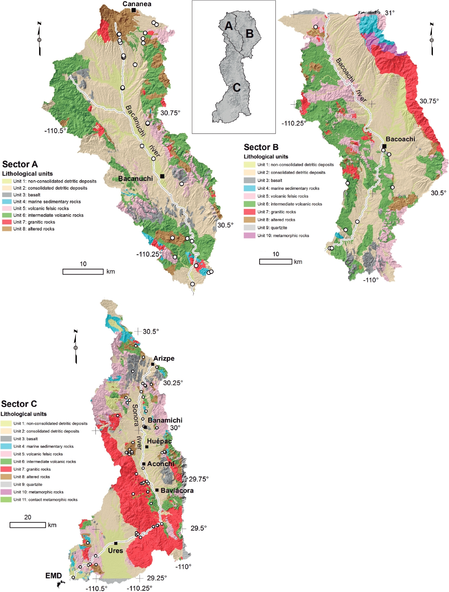
Figure 2 Map showing the sub-basins of the Sonora river upper basin, defined as sectors A, B and C, with the distribution of the 11 units categorized by lithological attributes, which are: Unit 1: non-consolidated detritic deposits; Unit 2: consolidated detritic deposits; Unit 3: marine sedimentary rocks; Unit 4: quartzite; Unit 5: granitic rocks; Unit 6: volcanic felsic rocks; Unit 7: intermediate volcanic rocks; Unit 8: basalt; Unit 9: metamorphic rocks; Unit 10: contact metamorphic rocks; Unit 11: altered rocks. White circles represent samples sites. Inset shows the division of the Sonora river upper basin in sectors A, B and C.
Sampling and Geographic Information System
The Sonora river upper basin was divided into three sectors, which correspond to the three main sub-basins (inset of Figure 2): (i) Sector A (1479 km2) corresponds to the watershed drained by the Tinajas creek, which received the spill in first instance, and the Bacanuchi river; (ii) Sector B (2278 km2) corresponds to the Bacoachi river sub-basin, and (iii) Sector C, which is the largest and southernmost sub-basin (5535 km2), and receives discharges from sectors A and B. Considering the lithological categorization, a total of 73 rock samples were selected to perform the geochemical studies (Figure 2).
Furthermore, sampling was constrained considering the area of exposure of each lithological unit, which was calculated for sectors A, B and C (Table 2), and recorded as an attribute to the sample. A geographic information system (GIS) was created using ArcGIS 10.3, in the UTM projection for the zone 12N, with WGS84 datum.
Table 2 Average concentrations of major (wt.%) and trace (ppm) elements for each lithologic unit in sectors A, B, and C of the Sonora river upper basin.
| Sector A | Sector B | Sector C | |||||||||||||||||||
|---|---|---|---|---|---|---|---|---|---|---|---|---|---|---|---|---|---|---|---|---|---|
| 1 | 2 | 4 | 5 | 6 | 7 | 8 | 1 | 2 | 4 | 5 | 6 | 1 | 2 | 3 | 5 | 6 | 7 | 8 | |||
| SiO2 | 65.4 | 61.3 | 55.6 | 71.1 | 65.2 | 66.6 | 75.0 | 65.9 | 62.7 | 95.3 | 70.7 | 55.3 | 66.2 | 70.2 | 55.5 | 72.6 | 72.3 | 72.8 | 71.2 | ||
| Al2O3 | 14.9 | 15.3 | 16.4 | 15.0 | 16.1 | 16.9 | 13.7 | 14.8 | 15.4 | 2.2 | 16.4 | 11.4 | 12.0 | 15.4 | 16.8 | 14.9 | 10.7 | 14.1 | 10.9 | ||
| FeOt | 4.5 | 6.6 | 6.8 | 3.5 | 4.5 | 3.2 | 2.5 | 5.1 | 5.9 | 1.0 | 2.3 | 2.0 | 7.9 | 3.6 | 8.5 | 2.4 | 4.0 | 2.6 | 3.4 | ||
| MnO | 0.1 | 0.1 | 0.1 | 0.1 | 0.1 | 0.1 | 0.1 | 0.1 | 0.1 | 0.0 | 0.0 | 0.1 | 2.0 | 0.1 | 0.1 | 0.1 | 0.1 | 0.1 | 0.1 | ||
| MgO | 2.0 | 2.0 | 6.6 | 0.5 | 4.1 | 1.2 | 0.7 | 2.1 | 2.8 | 0.3 | 0.7 | 0.8 | 1.0 | 0.9 | 3.6 | 1.7 | 2.0 | 0.9 | 1.3 | ||
| CaO | 7.6 | 9.0 | 7.8 | 3.4 | 1.5 | 3.4 | 1.7 | 6.0 | 5.1 | 0.3 | 0.5 | 24.0 | 6.7 | 3.5 | 7.1 | 2.7 | 6.0 | 2.1 | 8.3 | ||
| Na2O | 1.6 | 1.8 | 2.0 | 1.9 | 3.9 | 4.1 | 1.9 | 2.4 | 3.4 | 0.0 | 3.9 | 2.7 | 1.6 | 2.2 | 3.6 | 1.7 | 1.8 | 3.3 | 1.3 | ||
| K2O | 3.0 | 2.6 | 3.5 | 3.8 | 3.7 | 3.7 | 4.1 | 2.8 | 3.5 | 0.6 | 4.7 | 3.4 | 2.1 | 3.5 | 2.5 | 3.4 | 2.5 | 3.6 | 3.2 | ||
| TiO2 | 0.6 | 0.9 | 0.9 | 0.5 | 0.7 | 0.6 | 0.3 | 0.7 | 0.8 | 0.1 | 0.5 | 0.3 | 0.4 | 0.6 | 1.6 | 0.3 | 0.5 | 0.4 | 0.3 | ||
| P2O5 | 0.2 | 0.3 | 0.3 | 0.1 | 0.2 | 0.2 | 0.1 | 0.2 | 0.3 | 0.1 | 0.0 | 0.1 | 0.1 | 0.1 | 0.7 | 0.1 | 0.1 | 0.1 | 0.1 | ||
| Sc | 9.0 | 13.8 | 15.0 | 4.3 | 10.0 | 5.0 | 7.7 | 10.0 | 14.0 | 2.0 | 4.0 | 3.0 | 5.6 | 7.9 | 15.7 | 5.3 | 10.5 | 5.6 | 3.9 | ||
| Be | 1.5 | 1.6 | 2.0 | 1.8 | 2.0 | 2.0 | 2.3 | 2.0 | 2.0 | 1.0 | 2.0 | 1.8 | 2.5 | 2.4 | 2.0 | 3.1 | 1.5 | 2.4 | 2.0 | ||
| V | 77.5 | 136.6 | 121.5 | 46.3 | 96.0 | 57.0 | 39.3 | 100.0 | 118.3 | 22.0 | 37.0 | 25.0 | 51.8 | 74.3 | 159.3 | 37.5 | 86.0 | 36.6 | 30.1 | ||
| Ba | 1280.0 | 888.2 | 530.5 | 991.3 | 1226.0 | 1069.0 | 374.7 | 995.0 | 1088.5 | 1901.0 | 1317.0 | 895.3 | 528.8 | 838.0 | 1047.7 | 999.7 | 549.7 | 798.5 | 700.5 | ||
| Sr | 250.5 | 507.4 | 575.0 | 342.8 | 339.0 | 527.0 | 170.0 | 470.0 | 637.5 | 50.0 | 269.0 | 413.7 | 334.5 | 351.9 | 664.7 | 521.9 | 293.3 | 310.4 | 155.9 | ||
| Y | 23.5 | 22.8 | 20.5 | 19.8 | 21.0 | 18.0 | 30.0 | 21.0 | 24.3 | 15.0 | 23.0 | 16.0 | 16.3 | 19.9 | 32.0 | 25.0 | 19.0 | 20.9 | 24.4 | ||
| Zr | 178.0 | 188.4 | 150.5 | 127.3 | 214.0 | 216.0 | 195.7 | 179.0 | 195.8 | 99.0 | 238.0 | 163.3 | 151.5 | 164.4 | 322.0 | 160.0 | 158.3 | 168.0 | 140.9 | ||
| Cr | 35.0 | 56.0 | 135.0 | 10.0 | 90.0 | 10.0 | 10.0 | 60.0 | 77.5 | 70.0 | 10.0 | 13.3 | 27.5 | 21.4 | 63.3 | 15.7 | 53.3 | 40.0 | 30.7 | ||
| Co | 12.5 | 13.6 | 19.5 | 7.3 | 15.0 | 7.0 | 4.7 | 12.0 | 16.8 | 1.0 | 3.0 | 2.2 | 26.3 | 5.9 | 26.7 | 4.4 | 11.2 | 5.0 | 3.3 | ||
| Ni | 10.0 | 18.0 | 75.0 | 10.0 | 40.0 | 10.0 | 10.0 | 10.0 | 25.0 | 10.0 | 10.0 | 10.0 | 10.0 | 10.0 | 36.7 | 10.0 | 20.0 | 15.4 | 10.0 | ||
| Cu | 45.0 | 56.0 | 30.0 | 8.8 | 40.0 | 5.0 | 23.3 | 30.0 | 30.0 | 20.0 | 5.0 | 6.7 | 237.5 | 13.6 | 30.0 | 10.7 | 5.0 | 35.0 | 49.3 | ||
| Zn | 120.0 | 103.0 | 85.0 | 47.5 | 80.0 | 50.0 | 150.0 | 80.0 | 87.5 | 140.0 | 60.0 | 48.3 | 2536.5 | 68.6 | 100.0 | 69.3 | 43.3 | 74.6 | 835.7 | ||
| Ga | 15.5 | 16.0 | 19.5 | 14.8 | 20.0 | 20.0 | 21.7 | 15.0 | 17.0 | 4.0 | 18.0 | 12.7 | 15.0 | 16.9 | 20.3 | 15.7 | 12.7 | 17.0 | 13.4 | ||
| Ge | 1.0 | 1.1 | 1.3 | 1.4 | 1.0 | 2.0 | 1.0 | 1.0 | 1.8 | 3.0 | 2.0 | 0.8 | 1.0 | 1.7 | 1.3 | 1.6 | 1.2 | 1.9 | 1.4 | ||
| As | 25.0 | 25.4 | 5.3 | 9.4 | 36.0 | 2.5 | 16.2 | 20.0 | 28.5 | 8.0 | 2.5 | 2.5 | 8.4 | 16.1 | 4.0 | 9.8 | 2.5 | 2.5 | 70.5 | ||
| Rb | 103.5 | 88.0 | 72.0 | 130.5 | 124.0 | 132.0 | 208.3 | 91.0 | 112.0 | 39.0 | 165.0 | 99.0 | 79.8 | 145.3 | 61.0 | 122.9 | 84.7 | 167.7 | 146.5 | ||
| Nb | 7.5 | 8.4 | 8.0 | 7.0 | 8.0 | 9.0 | 8.7 | 8.0 | 9.0 | 4.0 | 9.0 | 6.3 | 8.1 | 10.0 | 16.3 | 16.7 | 7.2 | 11.4 | 9.1 | ||
| Mo | 1.0 | 1.6 | 1.0 | 1.0 | 2.0 | 1.0 | 1.3 | 1.0 | 1.0 | 7.0 | 1.0 | 1.0 | 2.8 | 1.1 | 1.0 | 1.1 | 1.0 | 1.5 | 2.7 | ||
| Ag | 0.4 | 0.5 | 0.4 | 0.3 | 0.7 | 0.3 | 0.4 | 0.3 | 0.4 | 0.7 | 0.7 | 0.5 | 9.3 | 0.6 | 0.8 | 1.0 | 0.4 | 3.1 | 1.5 | ||
| In | 0.1 | 0.1 | 0.1 | 0.1 | 0.1 | 0.1 | 0.1 | 0.1 | 0.1 | 0.1 | 0.1 | 0.1 | 0.1 | 0.1 | 0.1 | 0.3 | 0.1 | 0.1 | 1.0 | ||
| Sn | 1.5 | 1.3 | 1.5 | 0.6 | 1.0 | 2.0 | 2.3 | 1.0 | 1.3 | 0.5 | 0.5 | 0.7 | 2.9 | 1.6 | 2.0 | 3.6 | 1.5 | 1.3 | 1.8 | ||
| Sb | 9.4 | 7.2 | 2.4 | 12.1 | 0.9 | 0.3 | 4.7 | 4.5 | 4.3 | 4.3 | 0.3 | 0.8 | 1.7 | 5.8 | 0.3 | 3.3 | 0.8 | 0.5 | 6.9 | ||
| Cs | 14.3 | 8.2 | 6.8 | 10.0 | 6.7 | 3.7 | 20.1 | 9.2 | 10.7 | 5.4 | 6.5 | 6.0 | 5.7 | 16.6 | 2.2 | 18.1 | 7.0 | 2.7 | 6.9 | ||
| La | 30.1 | 33.4 | 27.9 | 29.1 | 39.8 | 38.2 | 38.4 | 29.3 | 31.8 | 13.5 | 41.1 | 33.3 | 26.2 | 31.3 | 52.0 | 38.6 | 19.2 | 33.8 | 29.7 | ||
| Ce | 61.0 | 67.6 | 58.7 | 61.1 | 78.8 | 72.5 | 77.6 | 56.6 | 66.3 | 25.4 | 68.7 | 61.6 | 51.2 | 60.6 | 108.3 | 74.4 | 38.3 | 62.5 | 60.6 | ||
| Pr | 7.0 | 7.9 | 7.1 | 6.3 | 8.8 | 7.7 | 8.7 | 6.5 | 7.5 | 3.3 | 8.2 | 6.4 | 5.8 | 6.8 | 12.5 | 7.8 | 4.5 | 6.5 | 6.3 | ||
| Nd | 25.8 | 30.2 | 27.6 | 23.9 | 32.5 | 27.6 | 32.3 | 24.1 | 28.6 | 12.6 | 30.2 | 21.9 | 21.2 | 24.2 | 49.4 | 26.0 | 16.3 | 22.3 | 22.0 | ||
| Sm | 5.3 | 5.7 | 5.3 | 4.7 | 5.7 | 5.0 | 6.1 | 4.7 | 5.7 | 2.6 | 5.0 | 3.4 | 3.8 | 4.5 | 9.5 | 4.6 | 3.3 | 3.9 | 3.9 | ||
| Eu | 1.2 | 1.4 | 1.4 | 1.0 | 1.2 | 1.1 | 0.5 | 1.1 | 1.3 | 0.4 | 1.1 | 0.7 | 0.8 | 1.0 | 2.4 | 0.7 | 0.7 | 0.9 | 0.7 | ||
| Gd | 4.2 | 4.8 | 4.7 | 3.6 | 4.5 | 3.6 | 4.9 | 3.9 | 5.0 | 2.3 | 4.3 | 2.5 | 3.1 | 3.9 | 7.8 | 4.0 | 3.3 | 3.4 | 3.4 | ||
| Tb | 0.7 | 0.7 | 0.7 | 0.5 | 0.6 | 0.5 | 0.8 | 0.6 | 0.8 | 0.3 | 0.6 | 0.4 | 0.4 | 0.6 | 1.2 | 0.6 | 0.5 | 0.5 | 0.5 | ||
| Dy | 3.9 | 4.0 | 3.8 | 3.1 | 3.3 | 2.7 | 5.0 | 3.5 | 4.2 | 2.0 | 3.5 | 1.9 | 2.6 | 3.1 | 6.4 | 3.8 | 2.9 | 3.0 | 3.3 | ||
| Ho | 0.8 | 0.8 | 0.8 | 0.6 | 0.6 | 0.5 | 1.0 | 0.7 | 0.9 | 0.4 | 0.7 | 0.4 | 0.6 | 0.6 | 1.2 | 0.8 | 0.6 | 0.6 | 0.7 | ||
| Er | 2.2 | 2.3 | 2.0 | 1.8 | 2.0 | 1.3 | 3.2 | 1.9 | 2.4 | 1.2 | 2.0 | 1.1 | 1.5 | 1.8 | 3.5 | 2.3 | 1.8 | 1.8 | 2.1 | ||
| Tm | 0.3 | 0.3 | 0.3 | 0.3 | 0.3 | 0.2 | 0.5 | 0.3 | 0.4 | 0.2 | 0.3 | 0.2 | 0.2 | 0.3 | 0.5 | 0.4 | 0.3 | 0.3 | 0.3 | ||
| Yb | 2.2 | 2.2 | 1.9 | 1.9 | 1.8 | 1.5 | 3.3 | 2.0 | 2.5 | 1.1 | 2.1 | 1.1 | 1.7 | 1.8 | 3.1 | 2.5 | 1.8 | 1.9 | 2.3 | ||
| Lu | 0.4 | 0.4 | 0.3 | 0.3 | 0.3 | 0.2 | 0.6 | 0.3 | 0.4 | 0.2 | 0.3 | 0.2 | 0.3 | 0.3 | 0.5 | 0.4 | 0.3 | 0.3 | 0.4 | ||
| Hf | 4.8 | 4.9 | 4.0 | 3.6 | 6.0 | 5.7 | 5.8 | 4.9 | 5.0 | 2.6 | 5.9 | 4.0 | 3.9 | 4.2 | 7.2 | 4.8 | 4.0 | 4.5 | 3.5 | ||
| Ta | 0.6 | 0.5 | 0.5 | 0.7 | 0.6 | 0.7 | 0.8 | 0.7 | 0.7 | 0.3 | 0.9 | 0.5 | 0.7 | 0.9 | 0.9 | 1.5 | 0.6 | 1.2 | 0.9 | ||
| W | 3.0 | 2.9 | 0.5 | 2.8 | 3.0 | 2.0 | 1.5 | 1.0 | 3.0 | 3.0 | 2.0 | 0.7 | 31.0 | 3.6 | 1.7 | 3.0 | 16.0 | 2.0 | 79.1 | ||
| Tl | 0.7 | 0.5 | 0.4 | 0.6 | 0.3 | 0.4 | 0.9 | 0.4 | 0.5 | 0.1 | 0.4 | 0.4 | 0.6 | 0.7 | 0.1 | 1.0 | 0.4 | 0.6 | 0.9 | ||
| Pb | 39.5 | 29.8 | 11.5 | 11.5 | 43.0 | 11.0 | 44.0 | 21.0 | 27.5 | 139.0 | 20.0 | 16.8 | 1082.3 | 24.7 | 12.3 | 224.0 | 8.0 | 358.8 | 101.0 | ||
| Bi | 0.5 | 0.3 | 0.2 | 0.2 | 0.2 | 0.2 | 0.6 | 0.2 | 0.2 | 0.2 | 0.2 | 0.2 | 16.9 | 0.5 | 0.2 | 0.3 | 0.2 | 1.2 | 0.6 | ||
| Th | 9.3 | 11.9 | 5.6 | 13.5 | 26.5 | 14.8 | 18.7 | 10.5 | 9.6 | 3.0 | 18.3 | 9.9 | 9.7 | 12.9 | 5.1 | 18.9 | 6.2 | 16.6 | 13.6 | ||
| U | 2.7 | 3.7 | 1.6 | 2.9 | 4.9 | 5.7 | 3.5 | 3.4 | 3.3 | 2.0 | 3.7 | 2.7 | 3.1 | 3.6 | 1.3 | 4.3 | 2.3 | 4.6 | 4.8 | ||
Preparation and analytical techniques
Rock samples were hammered in the collecting site to about a fist size, in order to avoid further contamination. The collected samples were crushed to fragments of about one cm in diameter, using a steel jaw-crusher at the Estación Regional del Noroeste, Universidad Nacional Autónoma de México (UNAM). A fraction of the crushed samples was sent to ActLabs laboratories in Canada, where they were powdered using an agate mill. The concentrations of major and trace elements were measured by geochemical packages Code 4B (lithium metaborate-tetraborate fusion ICP whole rock) and Code 4B2 (trace element ICP-MS), respectively.
Calculation of the geochemical background
The concentration average of each measured element was obtained considering the number of samples, and weighted taking into account the exposure area for each lithological unit from sectors A, B and C. Then, weighted average values of major and trace element for the three sectors were used to obtain the natural geochemical background of rocks from the entire Sonora river upper basin. Because of the comparatively small area covered by quartzite and regional metamorphic rocks of units 9 and 10, respectively, they were not considered in the calculation.
Results and discussion
Major and trace elements
The average concentrations of major and trace elements for samples from the lithological units of sectors A, B and C are shown in Table 2. The weighted average of elemental values of Sectors A, B and C, as well as the entire basin, are shown in Table 3. These values are considered to represent the geochemical background of the study area, and do not have any petrogenetic significance since the lithological units are constituted by geological formations of different nature and age. Figure 3 shows that the lithological units from the three sectors have similar geochemical patterns when normalized to the Upper Continental Crust (UCC) composition proposed by Rudnick and Gao (2003), defining a relatively narrow strip close to the reference line, for most elements, particularly for the rare earth elements group (REE).
Table 3 Weighted average of major (wt.%) and trace (ppm) element composition of rock samples from sectors A, B, and C. SRUB stands for the natural geochemical values for the Sonora river upper basin, calculated from sectors A, B and C, and weighted according to their areas. R&G are the elemental values of the upper continental crust according to Rudnick and Gao (2003).
| Sector A | Sector B | Sector C | SRUB | R&G | |
|---|---|---|---|---|---|
| SiO2 | 60.39 | 58.40 | 64.51 | 62.52 | 66.6 |
| Al2O3 | 14.25 | 13.65 | 13.62 | 13.73 | 15.4 |
| Fe2O3 | 5.16 | 5.40 | 3.31 | 4.06 | 5.04 |
| MnO | 0.09 | 0.11 | 0.07 | 0.08 | 0.1 |
| MgO | 2.23 | 2.37 | 1.14 | 1.58 | 2.48 |
| CaO | 4.65 | 5.57 | 4.54 | 4.78 | 3.59 |
| Na2O | 2.32 | 2.82 | 2.60 | 2.61 | 3.27 |
| K2O | 3.01 | 3.25 | 3.23 | 3.20 | 2.8 |
| TiO2 | 0.67 | 0.72 | 0.47 | 0.56 | 0.64 |
| P2O5 | 0.22 | 0.25 | 0.14 | 0.17 | 0.15 |
| Sc | 10.80 | 11.86 | 6.85 | 8.57 | 14 |
| Be | 1.82 | 1.97 | 2.32 | 2.16 | 2.1 |
| V | 100.82 | 101.22 | 56.67 | 73.39 | 97 |
| Ba | 971.68 | 1099.78 | 854.39 | 926.34 | 628 |
| Sr | 397.72 | 762.11 | 400.86 | 478.61 | 320 |
| Y | 22.78 | 22.68 | 22.07 | 22.32 | 21 |
| Zr | 191.37 | 192.98 | 174.22 | 181.03 | 193 |
| Cr | 55.88 | 72.50 | 29.41 | 42.98 | 92 |
| Co | 12.40 | 14.70 | 6.38 | 9.15 | 17.3 |
| Ni | 22.64 | 27.84 | 12.55 | 17.48 | 47 |
| Cu | 42.48 | 23.12 | 12.69 | 19.72 | 28 |
| Zn | 96.35 | 79.22 | 70.14 | 76.31 | 67 |
| Ga | 17.63 | 16.26 | 16.29 | 16.50 | 17.5 |
| Ge | 1.11 | 1.83 | 1.32 | 1.39 | 1.4 |
| As | 25.55 | 27.90 | 12.48 | 17.91 | 4.8 |
| Rb | 115.24 | 108.29 | 128.19 | 121.80 | 84 |
| Nb | 8.18 | 9.06 | 11.57 | 10.48 | 12 |
| Mo | 1.57 | 1.07 | 1.15 | 1.20 | 1.1 |
| Ag | 0.51 | 0.37 | 0.62 | 0.55 | 0.053 |
| In | 0.10 | 0.10 | 0.10 | 0.10 | 0.056 |
| Sn | 1.30 | 1.06 | 1.38 | 1.30 | 2.1 |
| Sb | 5.68 | 3.40 | 2.68 | 3.31 | 0.4 |
| Cs | 9.33 | 14.47 | 9.07 | 10.28 | 3.67 |
| La | 35.27 | 34.71 | 34.06 | 34.39 | 31 |
| Ce | 71.00 | 69.69 | 64.87 | 66.90 | 63 |
| Pr | 8.04 | 7.94 | 7.07 | 7.42 | 7.1 |
| Nd | 30.09 | 30.12 | 25.17 | 27.03 | 27 |
| Sm | 5.62 | 5.74 | 4.60 | 5.01 | 4.7 |
| Eu | 1.21 | 1.37 | 0.98 | 1.10 | 1 |
| Gd | 4.56 | 4.89 | 3.97 | 4.26 | 4 |
| Tb | 0.66 | 0.70 | 0.58 | 0.62 | 0.7 |
| Dy | 3.78 | 3.88 | 3.39 | 3.56 | 3.9 |
| Ho | 0.72 | 0.79 | 0.68 | 0.71 | 0.83 |
| Er | 2.22 | 2.18 | 1.98 | 2.06 | 2.3 |
| Tm | 0.32 | 0.33 | 0.30 | 0.31 | 0.3 |
| Yb | 2.15 | 2.23 | 2.04 | 2.10 | 1.96 |
| Lu | 0.36 | 0.34 | 0.33 | 0.34 | 0.31 |
| Hf | 5.22 | 4.84 | 4.60 | 4.75 | 5.3 |
| Ta | 0.61 | 0.68 | 1.07 | 0.91 | 0.9 |
| W | 2.77 | 2.53 | 3.83 | 3.38 | 1.9 |
| Tl | 0.52 | 0.46 | 0.58 | 0.54 | 0.9 |
| Pb | 33.76 | 23.92 | 20.13 | 23.14 | 17 |
| Bi | 0.30 | 0.20 | 0.32 | 0.29 | 0.16 |
| Th | 16.79 | 9.74 | 14.43 | 13.79 | 10.5 |
| U | 3.90 | 3.27 | 3.91 | 3.77 | 2.7 |

Figure 3 Multi-element diagrams normalized to the Upper Continental Crust (UCC) values of Rudnick and Gao (2003) for sectors A, B and C of the Sonora river upper basin; The thick solid line represents the weighted average value for each sector, considering the exposure area of the lithological units. See text for discussion.
The concentrations of CaO and P2O5 are around 1.5 times the UCC abundance, which is relatively more obvious in Sector C (Figure 4). The CaO anomaly may be associated with limestone, intermediate and felsic volcanic rocks, as well as with altered rocks. The relatively high values of P2O5 may be due to the influence of volcanic rocks. In contrast, Na2O is slightly depleted, probably indicating it was partially removed in solution. Moreover, manganese is commonly removed by hydrothermal fluids and weathering processes, and further deposited in cavities, fractures and crusts, mainly as oxides, hydroxides or carbonates (Figure 3).

Figure 4 Multi-element diagram normalized to the Upper Continental Crust (UCC) of Rudnick and Gao (2003) showing the weighted average values for sectors A (dotted line), B (dashed line), C (thin solid line) and for the entire basin (blue solid line).
Regarding the trace element concentrations, the three sectors display similar patterns with relative enrichments in As, Ag, Sb, Pb and Bi relative to the UCC (Figure 4). This enrichment is higher in Sector C, which is attributed to the influence of mineralized zones, particularly in San Felipe, Santa Elena and Baviácora (Figure 1). The enrichment of Ag, Sb and As is about 10 times the UCC; Ag and As concentration values are correlated to intermediate volcanic rocks and unconsolidated detrital deposits, whereas Sb is preferentially associated with felsic volcanic rocks, unconsolidated detrital deposits, and altered rocks. The other elemental positive anomalies (Ba, Cu, Pb, Bi, Th and U) are relatively more influenced by rocks of the Báucarit Formation and unconsolidated detrital deposits of the Sonora Group and, into a lesser extent, by altered rocks. The highly positive anomaly of W in Sector C is associated with the occurrence of scheelite-rich skarn deposits located in the Aconchi batholith, southwest of Baviácora (Figure 1).
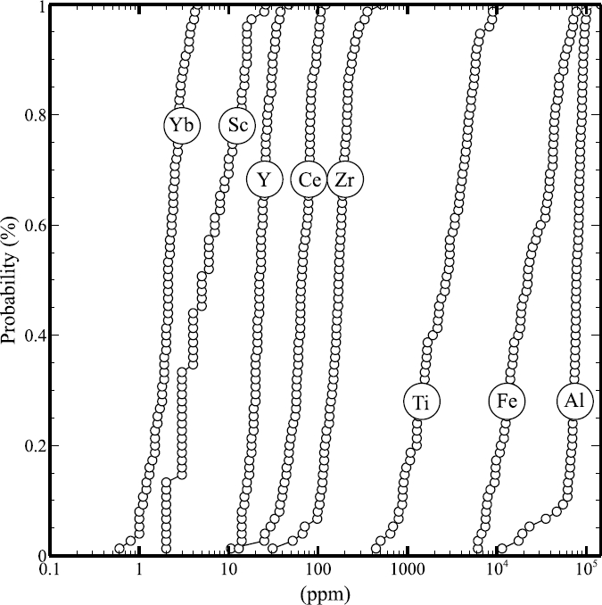
Conservative reference elements
Elements that are abundant in the Earth´s crust, and their concentrations are not substantially changed by human activities and the biogeochemical cycles, are referred to as conservative or reference elements (Galuszka and Migaszewski, 2011), which include Al, Zr, Sc, Cs, Ti, Y, Ce, among others. The coefficient of variation, defined as the ratio of the standard deviation () to the mean (x), is used to determine the conservative capability of an element (Reimann and de Caritat, 2005). However, some elements, traditionally considered as conservative, may display a similar or higher variability than certain elements considered as pollutants in environmental studies (Reimann and Garrett, 2005).
Commonly, the determination of environmental indexes (e.g. enrichment factor, geo-accumulation index, pollution index, concentration factor) is based on comparing the concentration of an element with a globally accepted reference, for instance, the continental crust (Monsalve et al., 2017; Saleem et al., 2018; Hasan et al., 2018). However, to obtain more realistic reference values, the using of elemental concentrations of either local or regional geochemical values is preferred by many authors (e.g.Kříbek et al., 2014; Wu et al., 2014; Zhang et al., 2014; Christou et al., 2017; Pan et al., 2017a; Pan et al., 2017b; Shang et al., 2017; Akopyan et al., 2018). Therefore, for the calculation of environmental indexes, particularly the enrichment factor, it is essential the using of conservative reference elements.
In the case of rocks of the Sonora river upper basin, the geochemical background shows a great variability in some elements due to the lithological diversity and the presence of locally altered and mineralized zones. According to the calculated coefficient of variation values (Figure 5), eight conservative reference elements were identified on the basis of their low coefficient of variation values (Sc, Y, Zr, Ce, Yb, Fe, Ti and Al). Therefore, these elements are recommended to assess contamination in environmental media (sediments, soils, surficial or underground water, etc.) to perform further studies in the Sonora river upper basin.
Regarding the elements commonly considered as potentially toxic, only As, Sb, Pb, W, Bi, Zn and Cu exhibit positive elemental anomalies in the geochemical background with respect to the UCC (Figure 4). Moreover, these elements are also characterized by having higher coefficient of variation values, as pointed out for soil samples from two large-scale geochemical studies in northern Europe (Reimann and de Caritat, 2005).
Implications for mining activities in Mexico
In Mexico, there is a lack of environmental regulations to establish a geochemical background prior to the development, or during the operation of a mine. As far as we know, this is the first large-scale study in Mexico that was carried out with the purpose of defining the geochemical background in a region, where mineralized areas are widespread, and mining industry is a priority activity. The establishment of the geochemical background should be considered as a basic tool to avoid misinterpretations of abnormally high elemental values, particularly those considered as potentially toxic, which can be wrongly attributed to mining activity instead of natural concentrations. For the case of the Sonora river upper basin, the geochemical background serves as a reference for the studied media in the region (e.g. soil, dust, sediments).
Conclusions
A geological survey was conducted in the Sonora river upper basin to establish its geochemical background. The basin was divided into three sectors, which represent the main three sub-basins. The rocks of the three sectors display similar geochemical patterns when normalized to the upper continental crust (Rudnick and Gao, 2003). These patterns define a narrow strip close to the reference line for the REE and relatively little variations for major elements. However, the data show that rocks from the three sectors exhibit naturally derived positive anomalies in some elements, particularly in Mn, Ca, P, Ba, Zn, As, Ag, Sb, W, Pb and Bi. Considering that soils and sediments are derived from surrounding rocks by weathering processes and pedogenesis, they may inherit the geochemical signature, which can be wrongly attributed to anthropogenic activities. Statistical data based on the coefficient of variation indicate that Sc, Y, Zr, Ce, Yb, Fe, Ti and Al can be considered as conservative reference elements, suggesting them as good candidates to determine environmental indexes in environmental studies in the upper Río Sonora basin.
As a summary of this study, the local geochemical background is preferred to the average values of the upper continental crust in environmental studies, because it takes into account the geological and lithological characteristics of the area. As a matter of fact, and considering that this is an important mining region at national scale, the obtained geochemical background sheds light regarding the natural concentration of some potentially toxic elements if released into the environment by natural and anthropogenic processes, that can be misinterpreted in environmental studies.

