


 nueva página del texto (beta)
 Inglés (pdf)
 Artículo en XML
 Referencias del artículo
 Enviar artículo por email
 Citado por SciELO
  Similares en
SciELO
Similares en
SciELO 
 Permalink
Introduction
According to Ricci Lucchi (1995), lacustrine deposits are ideal sites for paleoseismic investigations because they tend to contain a high percentage of fine grain material, which is very susceptible to shock-induced deformation, more than other grain sizes. These deposits record detailed and continuous geological-environmental events. Indeed, the analysis of detailed stratigraphy of deformation structures generated by earthquakes allows to establish correlations in different lacustrine environments (Sims, 1975).
In the Acambay graben, central Mexico, fault segments clearly show recent seismic activity. The most representative event is the Acambay earthquake of 1912, M = 6.9 (Urbina and Camacho, 1913). The lacustrine basin of San Pedro el Alto (SPA; Figures 1 and 2), immersed in the caldera of Temascalcingo Volcano (TV), is a major seismically active area of the Morelia-Acambay fault system, whose paleo-earthquakes are recorded as deformational structures (Garduño-Monroy et al., 2009; Rodríguez-Pascua et al., 2010). The sedimentary record includes lacustrine sediments interbedded with volcanic material wherein the seismic events were registered. The combination of the morphological, geological, seismo-tectonic and climatic factors of the zone, and the presence of soft-sediment deformational structures (SSDS or seismites), allow to deduce the behavior and the characteristics of the faults and structures generated by paleo-earthquakes that have formed the seismic landscape of the area (Michetti et al., 2000, 2005; Dramis and Blumetti, 2005; Audemard and Michetti., 2011). Sediments comprise both brittle and ductile deformation structures. The aim of this research is to describe the soft-sediment deformational structures recorded in the basin and to ellaborate about their possible seismic origin.


Geological-structural framework
The study area (Figure 1) comprises volcaniclastic and lacustrine sediments typical of central Mexico, a territory with major depressions and lacustrine basins. The morphology of the region presents various features such as semi-vertical slopes and escarpments with structural control of drainage and low degree of erosion. High resistance to weathering of recent dacitic rocks slows their disappearance (Martínez-Reyes and Nieto-Samaniego, 1990).
The Trans-Mexican Volcanic Belt (TMVB) shows a structural relationship between the alignment of volcanoes and cinder cones, and the fault structures trending between 40° and 110°. The Acambay graben is located 100 km northwest of Mexico City, is 40 km long and 15 km wide, shows an E-W-trending, and belongs to the Chapala -Tula Fault Zone (Suter et al., 1995). It is limited by the major Acambay-Tixmadejé fault to the north and the Pastores fault to the south.The Acambay graben contains the Central Faults System which strikes E-W with faults dipping up to 80° to the north and the south, and mainly affect the Temascalcingo Volcano (TV, Figures 1 and 2) (Martínez-Reyes and Nieto-Samaniego, 1990). Andesitic-basaltic lava cones are located at the edge of the caldera and on the flanks of the volcano. The caldera filling consists of stratified pyroclastic surges, volcanic breccias, reworked tuffs and lacustrine sediments (Roldán-Quintana et al., 2011). The rhyolite facies is apparently associated with ash fall deposits located on the SE flank of the TV; its age is 1.2 ± 0.13 Ma obtained by fission track dating (Mercer et al., 2002). The Pliocene-Quaternary TV belongs to an extensive system; climatic and environmental factors have contributed to its morphological evolution, mainly controlled by tectonic-earthquake activity, which dominates over surface erosion and sedimentation processes, allowing the preservation of coseismic deformation structures (Michetti and Hancock, 1997; Michetti et al., 2005; 2012). From 1593 to 1856, the caldera of the TV formed a natural lake; later, the San Pedro el Alto dam was built. The lacustrine deposits in the center of this basin consist of interbedded strata of ash and lapilli, and a few beds of coarser volcanic sediments. This material is in turn covered with lacustrine sediments composed of clays and silts, and locally with diatomite mixture. These deposits are often covered by fine volcanic ash that now is soil; according to structures observed, part of the sediments formed there could have recorded the secondary effects of seismic events and the faulting of the area.
Methodology
The analysis of deformational structures was performed with the coseismic stratigraphy approach (Garduño-Monroy et al., 2016). This method includes observation, analysis and characterization of the stratigraphic column and the seismic landscape. Trenching was carried out in three sites (Figure 2): two trenches, approximately 3 m deep, in the same fault segment, south of the dam inside the caldera, and the other trench to the north. The trenches were perpendicularly excavated to the fault trace. A grid of 1 m × 0.5 m was placed on both sides of each trench, allowing for a better identification, location and analysis of the geometry, stratigraphic units and coseismic structures. Using a gravity corer, we extracted three sediment cores: 85, 67, and 41.5 cm long, corresponding to the northern, central and southern part of the San Pedro el Alto dam, in order to study the lacustrine stratigraphy and the presence of soft-sediment deformational structures. A systematic description of the stratigraphic column was performed in outcrops, cores, and trenches. The sedimentary characteristics were also detailed recorded (texture, granulometry, roundness, thickness and continuity of strata, cyclicity, presence or absence of sedimentary structures). Additional data as size, material, shape, distribution and lateral continuity were described where soft-sediment deformational structures were identified.
Trenches and well cores
The excavation of trenches in deformation areas is the main source of information for paleoseismological studies (McCalpin, 2009). The sub-surface analysis enables the observation and identification of the main features that compose the stratigraphic column of the zone and allows the recognition of the secondary structures originated from past seismic events. For this reason, we carried out the analysis of soft-sediment deformation structures, which were identified by the opening and the study of the three trenches in two fault segments; two of them in the Temascalcingo fault, and one in the San Pedro fault. The deformational structures identified in the sedimentary well cores could be the result of similar events to those identified in the trenches. However, since there was no well core dating, it has not been possible to correlate the deformation structures of the dam with those identified in the trenches. Nevertheless, the age of the material that fills the cracks in both TRSPA1 and TRSPA2 has been correlated through 14C analysis.
TRSPA1
The trench (Figures 2 and 3) was excavated with a N-S orientation in the creep and escarpment formed in 1912 at the southern part of the San Pedro el Alto dam (Urbina and Camacho, 1913). The sedimentary sequence of the TRSPA1 (Figures 4, 5) is mainly composed of a mixture of volcanic material with some layers of silt and clay with low or zero diatomite content. However, the material of the layer that fills neptunian dikes or filled cracks shows a large number of diatom valves at its top, predominantly of benthic species with a mixture of planktonic diatom valves in lesser quantities. This indicates a shallow lacustrine environment. It should be noted that the diatomaceous valves also show a high fracturing degree, suggesting a high energy event that caused the mixing and rupture of valves. The stratigraphic column of the trench (Figures 4 and 5) is composed of three large sedimentary sequences, each of which includes several strata or units, mostly affected by fault activity with SSDS. From bottom to top this column consists of: 1) Fine volcanic material (ash) interbedded with thicker volcanic material (lapilli of 1-3 mm), 1.24 m-thick; 2) Alternation of volcanic material with clayey-silt, 1.32 m-thick. Most of the deformational structures were identified in this sequence, and, 3) A sequence of clay interbedded with silt, organic matter and very fine volcanic ash, 1.09 m-thick.
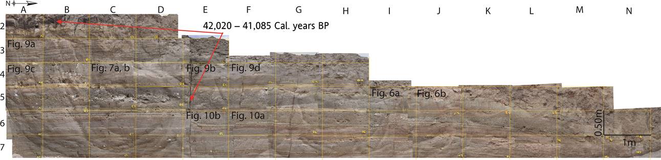
Figure 3 Section of the TRSPA1 indicating the location of some SSDS figures caused by seismic shocks, identified and described in this work.

Figure 4 Stratigraphic columns of TRSPA 1, 2, 3 and core 1 of the dam. Affected levels with soft-sediment deformational structures.

The analyzed sediments revealed soft-sediment deformational structures, probably generated by paleoseismic events. The most evident effects correspond to the surface escarpment linked to the 1912 seismic event, described as a crack by Urbina and Camacho (1913), and structures generated by older events: the walls of the trench showed a 22 cm vertical displacement of the sediments and its antithetic fault with a similar displacement. In addition, deformational structures were identified which will be described below.
TRSPA2
This trench was originally dug by locals to build a greenhouse. This excavation (Figure 2) encompasses an outcrop where the San Pedro fault is exposed with a 66 cm vertical displacement. The outcrop is part of a normal fault, trending ENE-WSW and dipping southward; evidences of the trace of this fault are strata displacement and ground cracking. The sedimentary succession is composed of lacustrine sediments with intercalation of volcanic material (Figure 4). We identified seven units affected by the fault activity with vertical displacement and cracks. Fractures and vertical displacement were observed in all layers of the trench. The plasticity of the clay permitted to fill the cracks produced by the seismic event, and even the continuity of the original layer was clearly identified. This suggests a sedimentary environment in which the sediments are not totally saturated at the time of their deformation; rather they are semi-consolidated sediments that behave in a mainly fragile manner. This trench features the effects of a single paleoseismic event, since the material that fills the cracks has an age of 41,500 Cal. years BP, the same age as the material that fills the cracks on the TRSPA1; also, faulting lifted the sedimentary succession. This event, older than the 1912 earthquake, is evidenced by the 66 cm, vertical displacement of strata of the sedimentary sequence of the trench. However, the actual fault displacement has been erased by the excavation for the construction of the current greenhouse at the top.
TRSPA3
This trench was carved in an extension of the Temascalcingo fault, near the San Pedro dam where TRSPA1 was dug. This area (Figure 2) has been described as a fracture resulting from the 1912 earthquake by Urbina and Camacho (1913). The outstanding structure of the trench is a crack filled with current soil material, as well as a large clay injection on the eastern wall, which is ductile, sedimentary material that was not fully consolidated at the time of the seismic event. Eight lithological clay units were identified in TRSPA3, including the material that fills the crack which is mixed with material from the layers that broke (Figure 4). The 1912 earthquake was the only paleoseismic event identified, and, as mentioned above, it generated the crack that is currently filled with clay material.
Although the SSDS are present throughout the study area, most were found in the walls of TRSPA1, near the SPA dam. It is in TRSPA1 that several strata with different types of SSDS were identified. One explanation could be that because the nearness to the dam, the water-saturated material is more susceptible to deformation and preservation of different structures. On the other hand, the other two trenches, which are further away from the dam, the material shows a different behavior and only the vertical displacement and the filled cracks have been preserved; the filling material became part of the soil at the time of the seismic event.
Well Cores
Three cores were recovered from the north, south and center of the SPA dam (Figure 2). Each core was divided into two parts; pictures were taken of each succession. The stratigraphic description of the sediments included identification of deformation structures. The sediments are composed of layers of clayey silt; the darker layers are the thinnest. These sediments are typical of relatively deep lacustrine environments, which is corroborated by the presence of diatoms, predominantly of planktonic species belonging to genera Aulacoseira, Cyclotella and Stephanodiscus. The association of these populations also suggests a not quite calm environment, because the Aulacoseira genus is central, planktonic, and indicative of turbid waters (Gasse, 1980), with phases of stress evidenced by sponge spicules and fragmented diatomaceous frustules. Particularly, the well core number 1, 85 cm long (Figure 4), which was taken from the northern part of the dam, shows slump type structures, as observed in the TRSPA1 strata.
Soft-sediment deformational structures
According to the criteria established by Seilacher (1969), the term "seismites" corresponds to a layer with structures formed in soft, sandy sediment due to overpressure or water saturation resulting from seismic vibration (Bowman et al., 2004; Montenat et al., 2007). However, the susceptibility to sediment deformation greatly depends on the size and arrangement of the sediment particles (Guiraud and Plaziat, 1993). The identification of the seismites is hampered by the fact that sometimes earthquakes may be just one among several trigger mechanisms sediment deformation (Mazumder et al., 2006). The structures identified in the SPA basin are not described in stratigraphic order but according to the type of structure.
Slumps
This kind of structures (Figure 4) were identified in four beds of the stratigraphic column of trench no. 1, in San Pedro el Alto (TRSPA1; Figures 3, 4, 5, 6 and 7b, 7c). The first, at 0.56 m from the base, is a 7 cm-thick monocline-like fold (Figure 6c), composed of ocher-colored volcanic ash and lapilli, 1 cm in diameter, in a thin layer of gray volcanic ash. This layer is fractured and displays vertical displacement in the walls of the trench.


Figure 7 Deformational structures corresponding to: a) load-flame structures, pseudonodules and, b) and c) slump-like identified in sediments of TRSPA1.
Another layer shows slump structures (Figure 6a, 6b) at 1.29 m from the bottom; it is 7 cm-thick and consists of pink silty clay interbedded with fine volcanic ash. Brittle behavior was observed in this layer; the slump structure is exposed in a zone of the trench with a 2 cm vertical displacement. An asymmetrical fold was observed in the trench: the hinge lines of the eastern and western walls appear in opposed directions; the hinge line of the W-wall shows northwards orientation, whereas the same structure on the E-wall strikes southwards. According to Alsop and Marco (2011), the explanation could be that during a progressive shearing, when the folds are forming, fold hinges and axial planes may undergo rotation.
Another layer of the same column (Figure 4), at 1.72 m from the base, includes a small slump, approximately 6 cm thick, composed of brown lapilli, brown volcanic ash and pink clay (Figure 7c). At the top of the layer, we found a mixture of fine lapilli and pink and brown clay. Small slumps and folds were observed at 1.51 m of the stratigraphic column (Figures 4, 7b).
The degree of disruption of the original lamination and the sediment mixing are generally mild in all of the slump structures that were observed, without becoming homogenites (Montenat et al., 2007). It is possible to recognize undeformed layers below the slump structures.
The sediment cores also show two slump structures. These small structures are generated in depositional environments, where there are no trace of slopes, and commonly observed in lacustrine deposits that display varved lamination (Montenat et al., 2007). The longest well core (Figures 4, 8) was extracted from the north side of the dam (Figure 2), near the artificial dike, in a water depth of 3.5 m. The core is 85 cm long, composed of clayey silt layers; between 14 and 17 cm, a small 1.6 cm-thick slump structure was found, similar to the one reported by Ezquerro et al. (2015) in the Jiloca and Teruel graben, Spain; the material forms structures with folds. The strata below and above of this structure are perfectly horizontal. Also, a more deformed structure, confined between horizontal strata, 4.2 cm high and between 38 and 40 cm, was observed.

Figure 8 Type slump structures in sediment of core 1, composed of layers of clayey silt from the San Pedro El Alto dam.
Interpretation
Slumps are associated to gravitational instabilities of sediments, mainly lateral driving-force systems (Moretti and Sabato, 2007), related to down-slope movements, even with low degree slopes. If the material is affected by an earthquake shock or by high sedimentary supply, shear strength is surpassed (Nichols, 2009) or displacement may occur, affecting the horizontality of the layer due to the break in the original slope. According to Rodríguez-Pascua et al. (2000), slumps can be generated by tectonic/sedimentary causes such as external drag mass overflow, tilted platforms by sediment overload, or earthquakes, among others. In a low degree slope as in the San Pedro el Alto zone (< 5°), the deformation could have started only after a reduction of the shear strength in the partially consolidated deposits (Owen, 1987; Martín-Chivelet et al., 2011). Therefore, the possible trigger agent could be an earthquake, because the slumps of this zone are generated on almost horizontal planes where the gravity would have an almost negligible effect. Furthermore, these structures, like the other ones described here, are well constrained because the upper and lower layers, remain horizontal with no deformation.
The lack of knowledge about the age of the different materials impedes the correlation of the structures. However, the presence of multiple slumps indicates a local trigger source such as an earthquake (Monecke et al., 2004), which can be used as a record of the sequence of seismic events (Montenat et al., 2007). Moreover, the fact that the same structure is also faulted and presents approximately 2 cm of vertical displacement (Figure 6b) may indicate that a second seismic event affected the slump previously formed by a first event.
The ESI-2007 (Michetti et al., 2007) was used to assess the intensity of the seismic event that might have generated each of the analyzed structures. ESI-2007 considers earthquake environmental effects (EEE) in twelve intensity degrees, and allows a comparison of contemporary events with historical records.
According to the characteristics of the ground, the kind of material and the thickness of the stratum, which is only between 6 and 7 cm, according to ESI 2007 scale (Michetti et al., 2007), the effect for these structures corresponds to intensity VIII.
Load-flame Structures
These structures are found in trench TRSPA1, in a 5 cm-thick silt-clay layer with a mixture of dark brown fine volcanic sand (Figure 7a). Their size varies between 0.5 and 4 cm in height; these are similar and related to load structures, as observed by Topal and Öskul (2014) in the Denizly Basin, Turkey. They consist of deformed layers covered by denser sediments of diverse size grain. Earthquakes of magnitudes 5 can originate flame structures in large areas; the liquefaction of silt caused by seismic shock results in the upward flow of the silt particles, introduced in upper layers, forming flame structures (Ambraseys, 1988; Audemard and De Santis, 1991; Rodríguez-Pascua et al., 2000). Earthquakes of lower magnitude do not last long enough to generate such structures (Rodríguez-Pascua et al., 2000).
Interpretation
Some researchers (e.g.Nichols, 2009) suggest that flame structures are inherently connected with load casts. Others (Ezquerro et al., 2015) propose that the phenomenon is a partial gravitational re-adjustment associated with load structures, when a low density material is covered by a mass of greater density, which causes instability and overpressure in the lower layer. Their behavior is due to differences in dynamic viscosity between sediments or to their reaction as diapiric intrusions (Topal and Öskul, 2014). The material tends to escape to the surface, distorting its top and intruding the overlying layer. However, in the case of the flame structures identified in our study area, the difference in density does not appear to be the cause or the only cause of the formation of flame structures, because the silty dark brown layer is covered by a less dense layer of very fine volcanic ash (Figure 7a). Taking into account this observation and the fact that the San Pedro el Alto dam is not a high energy lake and that does not have steep slopes, these structures could be linked to a seismic origin, even if silty material is more susceptible to liquefaction than ash. According to Newerth et al. (2006), uneven loading probably acted as a driving force, because there is no a big difference in densities, and the force is associated with variations in the distribution of sediment load when the substrate is liquefied and loses its supporting capacity. The stratum could be part of a sequence that records indirect evidence of an earthquake, which also includes the upper layer with pseudonodules (Figure 7a). The estimated intensity for these structures is VII on ESI 2007.
Pseudonodules
Common sediments in the study area include volcanic ash and fine sand. There are pseudonodules (deformational, composite, isolated structures) in sediment mass of various morphologies, embedded in a layer of different density (Rodríguez-Pascua et al., 2000).
The pseudonodules were identified in TRSPA1 (Figures 7a; 9a, 9b, 9c) in three stratigraphic levels (Figure 4); the deepest pseudonodules are composed of volcanic ash, are just over 10 cm length, and are included in volcanic sand (Figure 9b). The next level includes pseudonodules over 50 cm in length with the same lithology (Figure 9a). At the top layer, these structures are generally between 2 and 4 cm long (few reaching more than 5 cm). A series of clastic dikes separate and encloses a set of pseudonodules-like deformational bodies (Figure 9c), made of silt and sand; the stratification is cut by the dikes. The corners of the basal surface are rounded upwards (a feature that differentiates it from pillow structures), and the top is a flat surface covered by an even layer of brown, elutriated material.

Figure 9 Deformational structures considered sesimites, corresponding to a) and b) pseudonodules (ESI2007-VIII); c) and d) clastic dikes (ESI2007-VIII), all of these, identified in TRSPA1; e) diapir-like, large injection of pink clay into volcanic material (ESI2007-VIII), identified in TRSPA3.
Interpretation
This kind of structures are related to density difference between two layers. Normally, in the case of a seismic shock or sudden loading, the denser material sinks into the lower density material when the grains are re-accommodated by liquefaction. In the structures observed in SPA, the enclosed material made of fine volcanic ash and silt is less dense than where it is immersed in sand and sandy-silt. Here, unlike the cases described in the literature (where the denser material sinks into the less dense, becoming enclosed), it seems that it is the injection of the lower layer which ascends and forms dikes by fluidification, which cut and surrounds the volcanic ash, without folding upwards as in the pillow structures, but rather forms pseudonodules of lower density than the layer that now includes them.
A likely explanation is possible at the moment of seismic shaking when denser materials decrease their bulk density and shear strength by liquefaction effect, allowing the less dense material to sink (Rodríguez-Pascua et al., 2000); a similar process was proposed for the pseudonodules formed in the Híjar Basin in Spain: a diatomaceous marl, a sediment with lower density than a turbidite marlstone, includes pseudonodules. According to Rodríguez-Pascua et al. (2000), the pseudonodules could be formed by seismic events of M ≥ 6. In our case, fine volcanic ash was enclosed in a mixture of volcanic sand with clay of higher density than the ash. The interpretation of the seismic intensity deduced from these structures corresponds to VIII in ESI 2007.
Clastic Dikes
In SPA, clastic dikes were observed in the TRSPA1. The dikes form discordant and vertical conduits that cross the horizontal sedimentary laminae (Figure 9c). The sediment filling the conduits is composed of a mixture of silt and dark brown, fine volcanic sand. The dimensions of classic dikes ranges from 2 to 5 cm in height, and 1 to 2 cm in width. Upper parts of dikes end forming fine laminae at the base of the upper bed, composed of fine volcanic sand, which form rounded-upwards corners. These structures are related with the pseudonodules structures described above. Another clastic dike was identified in TRSPA1, involving sandy material with clayey silt mixture introduced into fine volcanic ash (Figure 9d); its length only reaches about 5 cm.
Interpretation
The main mechanism that forms dikes in lacustrine environments is hydraulic fracturing (Olson, et al., 2005). These structures can be formed when the sands are liquefied, possibly as the consequence of a seismic shock. The water-saturated material (sand and silt in the case of SPA) moves upward with high pore water pressure (Topal and Öskul, 2014). Based on the description of similar dikes given by different authors, Rodríguez-Pascua et al., (2000; 2010) conclude that these structures related to local seismicity have been generated by seismic events ranging between M = 5 and M = 8. The structures described here correspond to intensities between VII and VIII on ESI 2007.
Diapir-like or “Large Injection Structure”
This structure involves the liquefaction of a large body of sediment that results in the formation of a diapir (Figure 9e) of almost one meter in length in TRSPA3. The structure is composed of a pink clayey silt material which was injected up to the surface. Due to the type and size of the structure and the affected material, and taking into account the other effects analyzed in the area and described in this work, the diapir-like structure suggests a VIII intensity on ESI 2007.
Interpretation
This kind of structure is formed by mobilization of unconsolidated, overpressured sediments (Owen et al., 2011) by expulsion of pore water or gas. The introduction of material from the surface towards the base increases the pore pressure and gives way to the injection of material from the base towards the top. According to Owen et al. (2011), the movement of these sediments are driven by gravitational processes, even if they are not directly related to the surface, and their mobility is similar to surficial processes.
Filled Cracks or Neptunian dikes
The fracturess in SPA are mainly filled with dark clays cutting layers of fine sand, silt, and volcanic ash (Figure 10a, 10b, 10c). Clay, which functions as the fill material, moves from an inferior layer to the current soil. The majority of the cracks are filled at the base of the trench, at about 3.50 m, and their width or openings range from 1 to 3 cm, except for TRSP3, in which the crack is more than 30 cm wide. In most cases the dikes are vertical, introduced in fine, volcanic ash; the longest dike cuts the entire volcano-lacustrine sequence.

Figure 10 a), b) Vertical displacement and filled cracks with recent material in TRSPA1; c) filled crack or neptunian dike in TRSPA3; d) displacement of the San Pedro fault. Structures corresponding to intensities VII-X in ESI-2007.
Interpretation
The cracks are openings that occur on the surface due to seismic activity or by dissolution in a karst process (Nichols, 2009). They can also be the result of extension, escarpment relaxation, overload, or lateral spreading, that in some cases need a trigger mechanism such as an earthquake. According to Nichols (2009), cracks are distinguished from dikes because the former taper towards the base, can be filled with any size of clasts (common breccia), and can display multiple phases of opening and filling when related to earthquakes. However, neptunian dikes, filled from the top to the bottom, are the result of extension in cohesive sediments (Moretti and Sabato, 2007). In this case, after their opening, the cracks or neptunian dikes were filled by dark clay from an upper layer. The cracks of both TRSPA1 and TRSPA2 are filled with material of 41,000- 41,500 Cal. years BP, suggesting that they have been generated by the same event. Since the observed cracks are usually less than 10 cm wide, according to ESI 2007 these structures according to ESI 2007 scale these structures correspond to VII-VIII intensity.
Fault scarps
This kind of deformation affects several strata in the study area, in a range of some decimeters of vertical displacement. In trenches and outcrops, these structures (Figure 10a, 10b, 10d) are displaced between 2 to 66 cm. The lithology of the affected units involves intercalations of volcano-lacustrine material. In some of the sites they are associated with the filled cracks previously described.
Interpretation
These structures occur when the material does not have enough plasticity and the liquefaction of the sediments is impossible. The poorly consolidated and water-saturated sediments show a ductile deformation, or brittle deformation if there is a loss of fluids or volume, whereas those that are more consolidated and compact, with less saturation of water, behave like fragile sediment (Neuwerth et al., 2006). The result, during a seismic event, is brittle behavior, which is prominent in some areas. If we take into consideration the displacement that caused the surface rupture reported by Urbina and Camacho (1913) for the earthquake of 1912 in the area of San Pedro el Alto, and the displacement of strata analyzed in this work, which reaches 66 cm, according to ESI 2007 scale, these structures correspond to an intensity of IX-X.
Discussion
The stratigraphic analysis and identification of soft-sediment deformational structures were performed in three trenches and sediment cores recovered from the reservoir of San Pedro el Alto dam (Table 1).
Table 1 Earthquake environmental effects (EEE) and their correlation with event and intensity values in the ESI-2007 scale.
| EEE ID | Event | Location | EEE | Distribution | Intensity (ESI-2007) |
|---|---|---|---|---|---|
| 1 | I | TRSPA1 | Slump | Local | VIII |
| 1 | LL | TRSPA1 | Slump | Local | VIII |
| 2 | II, III | TRSPA1 | Load-flame structures | Local | VII-VIII |
| 3 | II | TRSPA1 | Pseudonodules | Local | VIII |
| 4 | II | TRSPA1 | Clastic dikes | Local | VIII |
| 5 | III | TRSPA3 | Diapir-like | Local | VIII |
| 6 | II, III | TRSPA1,2,3 | Filled cracks | Whole area | VII-VIII |
| 7 | II, III | TRSPA1,2,3 | Displacement | Whole area | VIII-X |
Deformational structures in the study area are principally produced by liquefaction and fluidization of sediments with different densities and loads as main driving forces. The morphology of the deformation structures mainly depends on the lithology of the stratigraphic column and its rheology, and on the deformation mechanism (Owen and Moretti, 2011; Ezquerro et al., 2015). However, the trigger mechanism that initiates the deformation of such materials provides important information on the prevailing conditions of the activity and evolution of the basins (Owen and Moretti, 2011). Among the most common trigger mechanisms, we can refer to ice-induced stresses, waves, sediment loading, storms, and seismicity. The latitudinal position of Mexico discards deformational structures by glacial environments. Shear stresses associated with tidal currents (e.g. Greb and Archer, 2007) need deep lake environments; the SPA lake is shallow and does not allow the formation of waves or currents produced by storms. In order to generate storm waves to produce liquefaction, the waves need to be more than 6 m high (Alfaro et al., 2002; Schillizzi et al., 2010). No sedimentary structures such as cross stratification caused by strong currents or waves were observed; also, the possibility of deformational structures originated by impacts such as volcanic bombs and rock drops, storm or current drag capable of producing liquefaction and fluidization of sediments is excluded. The best explanation of a trigger mechanism, in the present case, is seismic activity. An additional indicator is the occurrence of the structures in a continuous horizon. Earthquakes facilitate the destabilization of the phreatic level, and cause increased friction and destruction of the materials cohesion. In addition, earthquakes can cause the fluidization of granular solids, evidenced by the presence of flames and slip structures (slumps) characterized by deformation and fractures (Schillizzi et al., 2010).
Therefore, considering the seismic landscape (sensuMichetti et al., 2005) of the region and the characteristics of the deformational structures listed below, it is concluded that the most probable trigger mechanism was seismic activity. Structures described in this paper are similar to those deformational structures reported by several researchers in other areas (Montenat et al., 2007; Nichols, 2009; Schilizzi et al., 2010). Their development is associated with basins in an extensional environment with normal faults that control their evolution and geomorphology. Dikes and pseudonodules found in SPA are particularly similar to structures reported by Rodríguez-Pascua et al. (2010) in Tierras Blancas, where they are related to seismic events generated by the major fault structures of the Acambay graben, associated to magnitudes ≥ 5. The intensity of the effects generated by the Acambay 1912 earthquake on ESI 2007 is estimated between VIII-X, with significant destructive impact on the populations of the macroseismic area (Rodríguez-Pascua et al., 2012).
Furthermore, there are several criteria in accordance with Bowman et al. (2004) that suggest that the structures of San Pedro el Alto could be considered seismites. The following conditions were established to consider the structures as having been generated by seismic activity (Allen, 1986; Obermeier, 1996):
1) Our study area is located in the Acambay graben, one of the most important seismic areas of central Mexico (Ortuño et al., 2012), where several fault segments have left record of recent seismic activity and are part of the central fault system in the same graben.
2) The sedimentary succession consists of lacustrine sediments intercalated with unconsolidated volcanic material, which has led to mainly ductile-type deformation, recorded in sediments by liquefaction and fluidization. It should be noted that, although we are in a volcanic zone, only distal deposits of explosive volcanic activity are observed. This discards the possibility that the structures were generated by tremors of volcanic activity, which are generally of M < 5. Although the study area is located in the TV caldera, its activity is dated as 1 Ma (Roldán-Quintana et al., 2011). There are no recent, active volcanoes close enough to generate the identified structures.
3) There is similarity with structures produced experimentally in laboratory; seismic vibrations induced experimentally or artificially have been reported as seismic evidence (Hempton and Dewey 1983; Scott and Price, 1988). Additionally, there is similarity with structures reported by Rodríguez-Pascua et al. (2010) in Tierras Blancas, located within the same Acambay graben.
4) Most of our deformational structures were found where the slope is low (< 5), so their formation due to slip sediment without an earthquake as trigger mechanism is excluded.
5) The stratigraphy and its planar structure are affected only where seismites are located; the roof and floor strata remain horizontal.
6) The horizontal deformation of the affected layers has only been identified in distances of hundreds of meters. However, faults and deformation structures are observed throughout the area, in the three trenches, and in the sediments of the dam.
7) Cyclicity or recurrence of the seismic events. The stratigraphic column contains deformational structures and layers of the same composition that do not show deformation or disturbance. Identification of affected sedimentary sequences indicates at least three events in which the central fault system disturbed such sedimentary package.
Considering that the paleogeographic context of the area during sedimentation, and so far, has been tectonically active, the suggestion of the seismic origin of the structures seems logical. One of the strongest arguments to argue that deformation was induced by seismic effects is that layers with deformational structures alternate with undeformed horizontal layers. Interleaving material with similar characteristics and similar grain size is repeated in the same stratigraphic column, which rules out the influence of density difference as the only possible origin.
The reconstruction of the sedimentary succession in three trenches studied in the area of San Pedro el Alto, shows structural and sedimentological evidence of, at least, three earthquakes (Table 1, Figure 11). The ages of affected materials dates from 42,020 - 41,085 Cal years BP to 760 - 675 Cal years BP. The most probable age of the earthquakes was based on the stratigraphic and structural relationships. From the analysis of the sedimentary succession in the three trenches and one outcrop of the San Pedro fault on the Atlacomulco - Acambay highway, it is possible to correlate the seismic events that have affected the zone (Figure 11, Table 1). This correlation of events is mainly based on the similar age of the affected materials, defined by 14C analysis. The results obtained from the observation of diatoms in the massive stratum of organic matter of TRSPA1 stands out; the fragments of diatom valves, together with the location of the escarpment in which they are found, suggest an event previous to the 1912 earthquake, which generated breaking and lifted sediments, and caused the breaking of the valves. The age of the stratum (42,020 to 41,085 Cal years BP) suggests that it could have been a seismic event, the same that caused the displacement of sediments in this zone and the displacement of strata in the northern zone of the dam (TRSPA2). The ages of the earthquakes according to the dates of the material could correspond to the oldest earthquake reported in the Pastores fault (Langridge et al., 2013) and the Acambay fault of 1912 (Urbina and Camacho, 1913), respectively (Figure 11).

Figure 11 Spatial-temporal distribution of paleo-earthquakes in the Acambay graben. (Modified from Sunye-Puchol et al., 2015). The numbers in the San Pedro and Temascalcingo faults represent the identified earthquake environmental effect (EEE) kind (see Table 1). The black, horizontal lines indicate the maximum age range of the events; red horizontal bars indicate the preferential age range. Vertical, colored lines are the seismic events at the likely time according to the age data.
The analysis of secondary structures and their spatio-temporal distribution, identified in the San Pedro el Alto basin (Table 1), implies the existence of active faults belonging to the central system of the Acambay graben. The value of the macroseismic intensity ESI-07 within this zone, according to the studies structures ranges between VII and X. These structures and their intensity are tools that can be used to delineate hazard zones.
Conclusions
The stratigraphic analysis in the basin of San Pedro el Alto and the central fault system of the Acambay graben allowed the identification of seven, different soft-sediment deformation structures in disturbed layers, interpreted as seismites, according to their potential origin in earthquake shocks, and recorded in the proximal volcano-lacustrine sediments. Such structures correspond to at least three earthquakes. The seismites of the study area are associated to a morphological E-W tectonic control, and correspond to folds and slumps, load-flame structures, pseudonodules, clastic dikes, filled cracks, diapir-like, large-injection structures, and fault scarps. Such structures are identified, analyzed and described for the first time in this work.
The use of coseismic stratigraphy proved to be very successful to relate and evaluate the secondary seismic effects, which are not merely of sedimentary origin.
According to the analysis of such structures and in comparison with structures reported within the graben, and described in the literature for other regions of the world in addition to those generated in the laboratory (Ambraseys, 1988; Galli, 2000; Owen and Moretti, 2011), the minimum magnitude of seismic events required to generate the seismites identified in the area is M = 5. The analysis of these seismites on ESI 2007 corresponds to intensities between VII and X.
The results should be considered for evaluation of seismic hazard in the region. They suggest that earthquakes of similar magnitude could occur, as shown by the Acambay 1912 (Urbina and Camacho, 1913) and Maravatío 1979 (Astíz-Delgado, 1980) earthquakes, affecting one of the most densely populated areas of the country.
Thus, in this area of the Morelia-Acambay fault system there are solid evidences of earthquakes generated by these faults with magnitudes between 5 and 7. This is corroborated by the deformational structures and correlated with ESI 2007 with intensities between VII and X, whereby seismic hazard zones can be defined for the area.

