


Servicios Personalizados
Revista
Articulo
 Inglés (pdf)
 Artículo en XML
 Referencias del artículo
 Enviar artículo por email
Indicadores
-
 Citado por SciELO
 -
 Accesos
Links relacionados
-
 Similares en
SciELO
Similares en
SciELO
Compartir

 Permalink
Revista mexicana de ciencias geológicas
versión On-line ISSN 2007-2902versión impresa ISSN 1026-8774
Rev. mex. cienc. geol vol.32 no.1 Ciudad de México abr. 2015
Seismicity in the southwestern Gulf of Mexico: evidence of active back arc deformation
Sismicidad en el Sudoeste del Golfo de México: Evidencia de deformación activa tras-arco
Gerardo Suárez1,* and Astrid López2
1 Instituto de Geofísica, Universidad Nacional Autónoma de México, Ciudad Universitaria, C.P. 04510, México D.F., Mexico.*gerardo@geofisica.unam.mx
2 Posgrado en Ciencias de la Tierra, Universidad Nacional Autónoma de México, Ciudad Universitaria, C.P. 04510, México D.F., Mexico.
Manuscript received: May 20, 2014
Corrected manuscript received: July 28, 2014
Manuscript accepted: July 31, 2014
ABSTRACT
The earthquakes of 23 May 2007 (Mw 5.6) and 29 October 2009 (Mw 5.7) that occurred in the southern continental margin of the Gulf of Mexico were studied by conducting a full wave inversion of teleseismic P waves. In this region, there is a band of shallow seismicity along the continental margin that extends from the Isthmus of Tehuantepec to the city of Veracruz, Mexico. The focal mechanism of the 2009 event shows reverse faulting at a high angle and is very similar to that of the 1959 Jáltipan earthquake (Mw 6.4) and to the 1973 Veracruz event (Mw 5.3). The focal depths between 22 and 27 km of these three earthquakes are unusually deep for continental events. The location of this band of seismic activity and the focal mechanisms suggest a process of crustal shortening of the southern margin of the Gulf of Mexico. This compressive regime appears to be induced by the subduction of the Cocos plate to the south, in a manner that is reminiscent of the crustal shortening process observed in the Andes. The 2007 earthquake took place north of this region, seaward of the city of Tuxpan. The focal mechanism shows strike slip faulting and the hypocentral depth obtained from the body wave inversion is approximately 7 km. The source mechanism of this earthquake and the depth in the upper crust where it took place suggest a different tectonic process than the one observed near the Isthmus of Tehuantepec.
Key words: Gulf of Mexico, tectonics, crustal deformation, intraplate seismicity, seismic hazard.
RESUMEN
Los sismos del 23 de mayo de 2007 (Mw 5.6) y del 29 de octubre de 2009 (Mw 5.7) que tuvieron lugar en la margen continental sur del Golfo de México fueron estudiados haciendo una inversión formal de las ondas P registradas a distancias telesísmicas. En esta región existe una banda de actividad sísmica somera a lo largo de la costa que se extiende desde el Istmo de Tehuantepec hasta la ciudad de Veracruz, México. El mecanismo focal del sismo de 2009 muestra un mecanismo de fallamiento inverso de alto ángulo que es muy similar al observado en los sismos de Jáltipan de 1959 (Mw 6.4) y de Veracruz en 1973 (Mw 5.3). Las profundidades focales de estos tres sismos, que se encuentran entre los 22 y los 27 km, son inusuales para sismos que ocurren dentro de los continentes. La ubicación de esta banda de actividad sísmica y los mecanismos focales observados sugieren un proceso de acortamiento tectónico de la margen sur del Golfo de México. Este régimen compresional parece ser resultado de la subducción de la placa de Cocos hacia el sur. Este proceso geológico es similar al régimen tectónico compresivo observado en la margen oriental de los Andes. El sismo de 2007 tuvo lugar al norte de esta región, frente a las costas de la ciudad de Tuxpan. El mecanismo focal de este sismo muestra una falla transcurrente. La profundidad focal obtenida en la inversión es de aproximadamente 7 km. El mecanismo focal de este sismo y la profundidad dentro de la corteza superior, sugiere que aquí existe un proceso tectónico diferente al observado cerca del Istmo de Tehuantepec.
Palabras clave: Golfo de México, Tectónica, deformación cortical, sismicidad intraplaca, riesgo sísmico.
INTRODUCTION
The Gulf of Mexico has been considered traditionally as a passive margin and practically aseismic. Nonetheless, some infrequent earthquakes of moderate size have taken place in the gulf, mostly along the continental margins. In the northern Gulf of Mexico the magnitude of earthquakes has not exceed Mw 5.8 in instrumental times. In the southwestern Gulf of México, in the Isthmus of Tehuantepec, along the coast of the state of Veracruz, seismic activity is more frequent than in the rest of this basin and earthquakes with magnitudes as large as Mw 6.4 have been recorded.
Based on geological observations, De Cserna (1984) proposed that the southwestern Gulf of Mexico is undergoing a process of active tectonic deformation. He based his conclusion on the physiographic features of the coast. De Cserna (1984) argued that the cordillera Ordoñez is sharply truncated to the south of 20.50 N. Furthermore, the continental platform shows several anticlines that were presumably originated by compressional stresses (Moore and Del Castillo, 1974). De Cserna (1984) suggested that in this region of the Isthmus of Tehuantepec, the seafloor of the Gulf of Mexico subducts beneath the continental margin. However, there are none of the features that characterize a subduction zone. More likely, this zone is an area of intraplate, compressional tectonic deformation.
It is important to understand the reasons why these relatively large earthquakes occur in the southwestern corner of the Gulf of Mexico. In the last thirty years, the Mexican national oil company (PEMEX) has developed a vast and strategic infrastructure in this part of the country. In fact, the more important refineries and oil processing facilities of Mexico are located along the coast of the Isthmus of Tehuantepec. As a result of this industrial growth, the population has increased rapidly during the last 30 years. Assessing the seismic activity of this region and understanding its tectonic origin is fundamental in estimating the local seismic hazard. In this paper, the seismicity and the recent earthquakes taking place in the Isthmus of Tehuantepec are reassessed to determine their seismic source characteristics. This information is used to interpret the deformation of this back arc region.
SEISMICITY OF THE GULF OF MEXICO
The seismicity in the Gulf of Mexico is sparse and shows differing characteristics and tectonic origins (Figure 1). In the central part, few earthquakes occur and the majority of them are of small magnitude, M ≤ 5. Along the northern coast of the Gulf of Mexico, offshore the coasts of Louisiana and Mississippi in the United States, a few moderate sized earthquakes have been recorded. Frohlich (1982) studied an event, which took place in this region on 24 July 1978. Despite its low magnitude mb 5.0, Frohlich (1982) was able to determine the focal mechanism and depth of this earthquake. He interpreted this unusual event showing a reverse-faulting focal mechanism as evidence of lithospheric warping caused by the accumulation of sediments from the Mississippi River. The resulting focal depth of 15 km is near the base of the crust, in the region where Frohlich (1982) postulated an accumulation of stresses due to the warping of the lithosphere under the load of the sediment pile.
A few years later, a sequence of events occurred between February and September of 2006, offshore the coast of Louisiana (Nettles, 2006), not far from the 1978 earthquake reported by Frohlich (1982). Three earthquakes with magnitudes Mw 4.6, Mw 5.2 and Mw 5.8 took place in this region of intense hydrocarbon production and exploration. Based on a finite-element mechanical model, Gangopadhyay and Sen (2008) explained the occurrence of these earthquakes as resulting from shear stress build-up in the salt deposits. Gangopadhyay and Sen (2008) argued that these tabular and allochtonous salt deposits (Rowan, 1995; Orange et al., 2004) are strong enough to produce brittle failure under the appropriate conditions. Thus, the prevailing interpretation for the presence of these earthquakes in the northern Gulf of Mexico is the stress induced by the static load of the sediments of the Mississippi River delta in the lithosphere. The thick pile of sediments presumably causes large enough deviatoric stresses that induce seismic activity of relatively moderate magnitude (Frohlich, 1982; Nunn, 1985; Gangopadhyay and Sen, 2008).
The situation in the southwestern coast of the Gulf of Mexico is different from that to the north. Although the seismicity is not as frequent as it is along active plate boundaries, earthquakes that occur along the coast of the Isthmus of Tehuantepec are more frequent and of greater magnitude than in the rest of the Gulf of Mexico. Here, shallow earthquakes occur along the continental margin of the southwestern gulf, from the cities of Ciudad del Carmen to Veracruz (Figure 1). The rate of seismicity and the magnitude of these shallow earthquakes peak in the Isthmus of Tehuantepec and decreases away from it (Figure 1), suggesting that the largest stress concentrations are in the central part of the Isthmus.
In the instrumental period, the largest earthquake recorded in this region is the Jáltipan earthquake of 26 August 1959. At the time, this event Mw 6.4 caused relatively little damage for a shallow earthquake of this magnitude. The current industrial complex did not exist and the population was low. Nonetheless, it caused twenty casualties and widespread damage to constructions in the towns of Jáltipan and Acayucan in the state of Veracruz, including the incipient development of the sulfate processing industrial facilities. The only reference to earthquakes in pre-instrumental times comes from Acayucan where in December 1887 a newspaper report (La Estrella del Istmo, 1887) describes the presence of small and frequent earthquakes in the vicinity of the city, accompanied by underground noises (García Acosta and Suárez, 1996).
Suárez (2000) studied the two largest seismic events in the Isthmus of Tehuantepec for which a focal mechanism could be determined through the formal inversion of the P and S waves. His results showed that the earthquakes of 1959 in Jáltipan (Mw 6.4) and 1973 beneath the coast of the city of Veracruz event (Mw 5.3), share a similar mechanism consisting of reverse faulting at a high angle with the axes of maximum compression oriented northwest‐southeast. A remarkable feature of these two earthquakes is that the focal depths determined were 27 and 22 km deep, respectively. These depths are very unusual for intraplate earthquakes. Several authors show that intraplate earthquakes occur in the upper crust, at focal depths that are less than about 15 km (e.g., Chen and Molnar, 1983; Maggi et al., 2000).
ANALYSIS OF RECENT EVENTS ON THE CONTINENTAL MARGIN OF THE GULF OF MEXICO
A review of the seismicity along the Gulf of Mexico shows that two more earthquakes that are large enough to be able to obtain a reliable focal mechanism have taken place recently (Suárez and López, 2011). One of these earthquakes occurred on 29 October 2009 (Mw 5.7) offshore the coast of the town of Alvarado, and the other on 23 May 2007 (Mw 5.6) to the northeast of the city of Tuxpan (Figure 1).
For both the 2007 and 2009 earthquakes, records of P waves recorded in worldwide stations were collected (http://www.iris.edu) to apply the inversion scheme proposed by Nabelek (1984) and adapted by McCaffrey et al. (1991). The algorithm inverts the full waveforms of the P and S waves to the best fitting focal mechanism. The inversion is performed at different trial depths and the minimum in the variance between the results of the inversion and the observed seismograms is used to determine the best fitting source mechanism. The crustal model proposed by Moore and Del Castillo (1974) was used in the inversion to calculate the travel times of the body waves in the crust.
In the case of the 29 October 2009 earthquake, a total of 10 seismic stations were selected in the inversion process. Successive inversions at different trial depths indicate a clear minimum in variance at a depth of approximately 27 km between the synthetic and the observed seismograms (Figure 2). This minimum is assumed to be the focal depth of this earthquake offshore the city of Alvarado, Veracruz. The resulting focal mechanism is similar to the one reported by the Global Centroid Moment Tensor Catalog (Dziewonski et al., 1981; Ekström et al., 2012). The focal mechanism of the 2009 earthquake and a comparison between the observed and the synthetic seismograms are shown on Figure 3. The type of faulting and the depth of the 2009 event are very similar to those determined for the 1959 Jáltipan and 1967 Veracruz events (Suárez, 2000).

The earthquake of 23 May 2007, offshore the city of Tuxpan, was not as well recorded by the worldwide network of seismic stations as the 2009 event. In this case, there were not many clearly recorded long-period P waves. The signals recorded at six teleseismic stations were used in the inversion algorithm. As described before, the inversion was conducted at different trial depths. The maximum variance reduction was obtained at a depth of approximately 7 km (Figure 2). At this depth, the fit between the synthetic seismograms generated using the resulting focal mechanism match the observed waveforms (Figure 4).
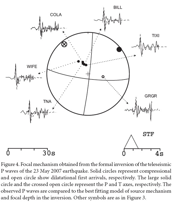
The resulting source mechanism for the 2007 earthquake is different from those determined further south for the 1959, 1967 and 2009 events. The 2007 earthquake is much shallower than the events further south and shows strike-slip faulting with the axes of maximum compression oriented northeast-southwest. Furthermore, this earthquake lies offshore and not along the coastline as the other earthquakes farther south.
TECTONIC INTERPRETATION
The tectonic deformation of the continental margin of the southern Gulf of México, as evidenced by the presence of shallow crustal seismicity and moderate sized earthquakes is concentrated in the southwestern coast of the Gulf, between the cities of Ciudad del Carmen and Veracruz (Figures 1 and 5). To the east of Ciudad del Carmen and to the north of Veracruz, the seismicity decreases sharply and the average magnitudes of the earthquakes are smaller. In particular, the cluster of small magnitude seismic events located north of Ciudad del Carmen may be due to stress changes induced by fluid extraction during oil and gas production. A phenomenon observed in Texas under similar conditions (e.g., Davis et al., 1995).
The earthquake that took place on 23 May 2007 (M5.6), offshore the city of Tuxpan, shows a strike-slip focal mechanism (Figure 4). Although the source mechanism is different to the earthquakes to the south, the axes of maximum compression are also oriented in northeast‐southwest direction (Table 1). This event took place beneath the Cordillera Ordoñez at a focal depth of 7 km. This shallow focal depth is in sharp contrast to the deeper earthquakes to the south. It is difficult to know, with the information on hand, whether these two groups of earthquakes have the same tectonic origin. The shallow depth of the 2007 Tuxpan earthquake indicates that this earthquake occurred in the upper crust. This focal depth and the paucity of events in this region suggest this event may be due to a different tectonic process than that present farther south. Furthermore, the 2007 earthquake took place about 70 km offshore, in the Cordillera Ordoñez, and not beneath the continental margin.
The larger events of this band of shallow earthquakes along the coastal margin of the Gulf of Mexico occur between the city of Veracruz and Coatzacoalcos. Seismic coverage in the area has been traditionally poor (Franco et al., 2013). The sparse seismic coverage, coupled to the small number of earthquakes that are large enough to generate a reliable focal mechanism from teleseismic data, have hindered the study of the tectonic behavior of this region. In the last 55 years, only three earthquakes have occurred in this zone with magnitudes large enough to generate a reliable fault plane solution using teleseismic data from global seismic stations. The three earthquakes located show focal mechanisms that are very similar. In all cases, the axes of maximum compression of the source mechanism indicate the presence of a compressional tectonic regime oriented northeast southwest.
The earthquake offshore the city of Alvarado of 2009, (Mw 5.7) is not far from the 1973 Veracruz earthquake (Figure 5) with a high-angle reverse faulting as focal mechanism and focal depth of about 27 km (Suárez, 2000) (Table 1). This event shares the direction of maximum compression in a northeast to southwest direction, as the Jáltipan and Veracruz events, and a relatively deep hypocenter for an intraplate event. The high‐angle reverse faults observed for the three events in the southern Gulf of Mexico suggest that a compressional tectonic regime is active in this region. This tectonic regime suggests deep crustal deformation probably induced by the subduction of the Cocos plate to the south.
The focal depths reported for the 1959, 1973 and 2009 earthquakes are unusual for intraplate events (Table 1). Global studies of intraplate earthquakes indicate that the majority of these events located away from plate boundaries have depths shallower than 15 km (e.g., Chen and Molnar, 1983; Maggi et al., 2000). These observations have been used to model the rheological behavior of the crust. Maggi et al. (2000) suggest that the lower crust does not support brittle failure. These authors suggest that intraplate earthquakes deeper than approximately 15 km occur in the upper mantle.
The crustal thickness along the continental margin of the southern Gulf of Mexico has been determined on the basis of seismic refraction experiments, the calculation of receiver functions from teleseismic data and gravity surveys. All of these studies suggest that the crustal thickness decreases rapidly from about 45 km in central Mexico towards the coastal plains (Valdes et al., 1986; Nava et al., 1988; Molina-Garza and Urrutia-Fucugauchi, 1993; Campos-Enríquez and Sánchez-Zamora, 2000; Melgar and Pérez-Campos, 2011). Most of these studies suggest that the crust near the coast of the Gulf of Mexico is about 30 km thick. However, it is unclear how rapidly it thins offshore the continental margin, where the earthquakes reported here are located. Thus it is unclear whether these earthquakes in the southern gulf take place in the lower crust or in the mantle.
The presence of reverse-faulting earthquakes in the back arc of the Middle American subduction zone and the relatively deep location of these earthquakes, as compared to other intraplate events, is reminiscent of observations made in the back arcs of other subduction zones. In South America, for example, there is an active seismic zone to the east of the Andes beneath the sub-Andean margin that separates the high Andes from the Amazonian shield. In this region, the earthquakes show high-angle reverse faulting mechanisms at focal depths ranging approximately from 30 to almost 50 km (Suárez et al., 1983; 1990; Sébrier et al., 1985; Dorbath et al., 1991).
These earthquakes have been interpreted as reflecting the deformation of the back arc of the Andean subduction zone due to the compressional stress exerted by the subduction zone to the west (Suárez et al., 1983; 1990; Sébrier et al., 1985; Dorbath et al., 1991; Lamb, 2000). Crustal shortening and the eastwards growth of the Andes take place as a result of the underthrusting of the Brazilian shield beneath the eastern margin of the mountain range (Suárez et al., 1983; Dorbath et al., 1991). The seismic activity in the sub-Andean margin reflects this deformation and takes place in the crust of the Brazilian shield underthrust beneath the mountain belt. Lyon-Caen et al. (1985) demonstrated that the flexure of the Brazilian shield as it underthrusts the Andes is clearly reflected as a gravity anomaly. Lyon-Caen et al. (1985) estimate that up to 100 km of shortening have taken place.
We suggest that a scenario of crustal shortening, similar to the one in the Andean region, may be taking place in the Gulf of Mexico. The compressional earthquakes in this back arc region of the Cocos subduction zone appear to reflect crustal shortening induced by the subduction process. The presence of the Tehuantepec Ridge, a topographic high now being subducted by the Middle American Trench, along the Pacific coast of the Isthmus of Tehuantepec, probably increases the horizontal stresses induced by the subduction process. These intraplate events in the back arc of the Isthmus of Tehuantepec reflect the tectonic deformation induced by the subduction to the south. The anticlines reported by Moore and Del Castillo (1974) may represent the surface expression of this compressive regime.
Alternatively, it is possible that the compressive regime we see today is a present day remnant of the collision and subduction of the Yucatan block that presumably took place during the Miocene (Chen and Clayton, 2012).
Additional evidence of the underthrusting beneath the coast of the southern Gulf of Mexico comes from the studies of anisotropy in this region. Based on numerical studies Schellart and Moresi (2013) suggest that a driving mechanism potentially inducing a compressional regime in the back arc is favored by poloidal asthenospheric flow in the mantle wedge. León-Soto and Valenzuela-Wong (2013) measure shear-wave splitting using S waves from local earthquakes recorded near the coast of the Gulf of Mexico in the Isthmus of Tehuantepec. A geometrical distribution of earthquakes and seismic stations allowed a detailed sampling of the mantle wedge. The results of León-Soto and Valenzuela-Wong (2013) indicate the presence of poloidal flow in the mantle wedge above the Cocos slab. If this were true, the poloidal flow observed in the mantle wedge may induce the compressional regime in the back arc that we observe along the southeastern coast of the Gulf of Mexico.
SUMMARY AND CONCLUSIONS
There is a band of shallow seismicity along the continental margin of the southern Gulf of Mexico. This band of activity extends from the city of Ciudad del Carmen to the city of Veracruz. The rate of seismic activity in this region is very low by comparison to active plate boundaries. Nevertheless, this shallow seismic activity observed in the Isthmus of Tehuantepec is the more active zone of intraplate seismicity in Mexico.
The number of earthquakes recorded during the past forty years in the southern gulf shows a much higher rate of occurrence than the seismicity to the north and in the center of it. The seismic activity in the northern part of the Gulf of Mexico has been attributed to the load of the sedimentary pile deposited on the Mississippi River delta. To the south, the tectonic behavior appears to be different. Here, the magnitude of the larger earthquakes and the rate of seismic activity are higher than it is in the northern gulf.
Earthquakes in the crescent of seismic activity in the southwestern corner of the gulf show source mechanisms reflecting reverse faulting at a high angle. The focal depths are unusually deep for continental earthquakes. Here, the crustal thickness is not well known and it is unclear whether they take place in the crust or in the mantle. This tectonic environment showing continental shortening in the back arc of an active subduction zone is similar to that observed in the Andes, where the sub-Andean margin undergoes a process of crustal shortening due to the compressive stress induced by the subduction of the Nazca plate to the west. The focal mechanisms of earthquakes in the sub-Andes that reflect this process of crustal shortening are similar to those observed in the southern Gulf of Mexico. In both cases, it appears that the continental back arc is undergoing a process of active compressional deformation due to the horizontal stresses induced by the subduction. In Mexico, this state of stress appears to increase due to the subduction of the Tehuantepec Ridge, a topographic high now being subducted in the trench.
As de Cserna (1984) pointed out, geological evidence offshore suggests that a process of continental shortening and deformation is taking place in the southwestern Gulf of Mexico. The anticlines observed offshore in this region may be evidence of this tectonic process (Moore and Del Castillo, 1974). Detailed geodetic surveys, seismic reflection and refraction profiles and a better seismic coverage in this area would help to discern in more detail the origin and tectonic structure of this zone of intraplate seismic activity. These earthquakes, albeit of moderate magnitude, represent a seismic hazard to the local population and to the oil infrastructure now present in the area.
ACKNOWLEDGEMENTS
The authors acknowledge grant number 082821 from the Mexican Council of Science and Technology (CONACYT) for support in conducting this work. Astrid López thanks CONACYT for an undergraduate thesis fellowship. A. Iglesias helped us in developing the computer programs. D. Novelo-Casanova read the manuscript and provided valuable comments. The authors are grateful for the constructive comments and suggestions made by G. León-Soto and an anonymous reviewer. Their input greatly improved the manuscript.
REFERENCES
Campos-Enríquez, J.O., Sánchez-Zamora O., 2000, Crustal Structure across southern Mexico inferred from gravity data: Journal of South American Earth Sciences, 13, 479-489, doi:10.1016/S0895-9811(00)00045-6. [ Links ]
Chen, W.P., Molnar P., 1983, Focal depths of intracontinental and intraplate earthquakes and their implications for the thermal and mechanical properties of the lithosphere: Journal of Geophysical Research, 88(B5), 4183-4214, doi:10.1029/JB088iB05p04183. [ Links ]
Chen, T., Clayton, R.W., 2012, Structure of central and southern Mexico from velocity and attenuation tomography: Journal of Geophysical Research, 117, doi: 10.1029/2012JB009233. [ Links ]
Davis, S.D., Nyffenegger P.A., Frohlich C., 1995, The 9 April 1993 earthquake in south-central Texas: Was it induced by fluid withdrawal?: Bulletin of the Seismological Society of America, 85, 1888-1895. [ Links ]
De Cserna, Z., 1984, Margen de Colisión Activo en la parte Suroccidental del Golfo de México: Revista del Instituto de Geología, 5, 255-261. [ Links ]
Dorbath, L., Dorbath, C., Jiménez, E., Rivera, L., 1991, Seismicity and tectonic deformation in the Eastern Cordillera and the Sub-Andean zone of central Peru: Journal of South American Earth Sciences, 4, 13-24, doi:10.1016/0895-9811(91)90015-D. [ Links ]
Dziewonski, A.M., Chou, T.A, Woodhouse, J.H., 1981, Determination of earthquake source parameters from waveform data for studies of global and regional seismicity: Journal of Geophysical Research, 86, 2825-2852, doi:10.1029/JB086iB04p02825. [ Links ]
Ekström, G., Nettles M., Dziewonski A.M., 2012, The global CMT project 2004-2010: Centroid-moment tensors for 13,017 earthquakes: Physics of the Earth and Planetary Interiors, 200, 1-9, doi:10.1016/j.pepi.2012.04.002. [ Links ]
Franco, S.I., Canet C., Iglesias A., Valdés-González C., 2013, Seismic Activity in the Gulf of Mexico. A preliminary analysis: Boletín de la Sociedad Geológica Mexicana, 65, 447-455. [ Links ]
Frohlich, C., 1982, Seismicity of the central Gulf of Mexico: Geology, 10(2), 103-106, doi: 10.1130/0091-7613. [ Links ]
Gangopadhyay, A., Sen M.K., 2008, A possible mechanism for the spatial distribution of seismicity in northern Gulf of Mexico: Geophysical Journal International, 175, 1141–1153, doi: 10.1111/j.1365-246X.2008.03952.x. [ Links ]
García Acosta, V., Suárez, G., 1996, Los sismos en la historia de México: Fondo de Cultura Económica, México D.F., 718 pp. [ Links ]
Lamb, S., 2000, Active deformation in the Bolivian Andes, South America: Journal of Geophysical Research, 105(B11), 25,627-25,653, doi:10.1029/2000JB900187. [ Links ]
León-Soto, G., Valenzuela-Wong, R.W., 2013, Corner flow in the Isthmus of Tehuantepec, Mexico inferred from anisotropy measurements using local intraslab earthquakes, Geophysical Journal International, 195, 1230-1238, doi: 10.1093/gji/ggt291. NOT CITED [ Links ]
Lyon-Caen, H., Molnar P., Suárez G., 1985, Gravity anomalies and flexure of the Brazilian Shield beneath the Andes: Earth and Planetary Science Letters, 75, 81-92. doi:10.1016/0012-821X(85)90053-6 [ Links ]
Maggi, A., Jackson J.A., McKenzie D.M., Priestly K., 2000, Earthquakes, focal depths, effective elastic thickness, and the strength of the continental lithosphere: Geology, 28, 495‐498, doi:10.1130/0091-7613. [ Links ]
McCaffrey, R., Abers G., Zwick P., 1991, Inversion of Teleseismic Body Waves, in Lee, W.H.K. (ed.), Digital Seismogram Analysis and Waveform Inversion: IASPEI Software Library, 3, IASPEI/SSA, 81-166. [ Links ]
Melgar, D., Pérez-Campos, X., 2011, Imaging the Moho and subducted oceanic crust at the Isthmus of Tehuantepec, Mexico, from receiver functions: Pageoph, 168, 1449-1460, doi: 10.1007/s00024-010-0199-5. [ Links ]
Moore, G.W., Del Castillo L., 1974, Tectonic evolution of the southern Gulf of Mexico: Geological Society of America Bulletin, 85(4), 607-618. [ Links ]
Molina-Garza, R., Urrutia-Fucugauchi J., 1993, Deep crustal structure of central Mexico derived from interpretation of Bouguer gravity anomaly data: Journal of Geodynamics, 17, 181-201, doi:10.1016/0264-3707(93)90007. [ Links ]
Nábelek, J.L., 1984, Determination of earthquake source parameters from inversion of body waves: Cambridge, Mass., USA, Massachusetts Institute of Technology, Ph.D Thesis, 280 pp. [ Links ]
Nava, F., Núñez-Cornú F., Córdoba D., Mena M., Ansorge J., González J., Rodríguez M., Banda E., Mueller S., Udías A., García-García M., Calderón G., 1988, Structure of the Middle America Trench in Oaxaca: Tectonophysics, 154, 241-251. [ Links ]
Nettles, M., 2006, Analysis of the 10 February 2006: Gulf of Mexico earthquake from global and regional seismic data: Houston Texas, USA, Offshore Technology Conference. Proceedings, paper no. 19099, 2007. [ Links ]
Nunn, J.A., 1985, State of stress in the northern Gulf of Mexico, Geology, 13, 429-432. [ Links ]
Orange, D.L., Angell, M.M., Brand J.R., Thomson J., Buddin T., Williams M., Hart W., Berger III W.J., 2004, Geologic and shallow salt tectonic setting of the Mad Dog and Atlantis fields: relationship between salt, faults, and seafloor geomorphology: Leading Edge, 23, 354-365. [ Links ]
Rowan, M.G., 1995, Structural styles and evolution of allochthonous salt, Central Louisiana Outer Shelf and Upper Slope: AAPG Memoir, 65, 199-228. [ Links ]
Schellart, W. P., Moresi, L. 2013, A new driving mechanism for backarc extension and backarc shortening through slab sinking induced toroidal and poloidal mantle flow: Results from dynamic subduction models with an overriding plate: Journal of Geophysical Research, 118, 3221-3248, doi: 10.1002/jgrb.50173. [ Links ]
Sébrier, M., Mercier J.L., Mégard F., Laubacher G., Carey-Gailhardis E., 1985, Quaternary normal and reverse faulting and the state of stress in the central Andes of south Peru: Tectonics, 4(7), 739-780, doi:10.1029/TC004i007p00739. [ Links ]
Suárez, G., 2000, Reverse faulting in the Isthmus of Tehuantepec: Backarc deformation induced by the subduction of the Tehuantepec ridge, in Delgado, H., Aguirre, G., Stock, J., (eds), Cenozoic Tectonics and Volcanism of Mexico: Geological Society of. America Special Paper, 334, 263‐268. [ Links ]
Suárez, G., López, A., 2011, Crustal deformation in the southwestern Gulf of Mexico - Evidence for thrust faulting induced by the subduction of the Cocos plate, in Simposio Dr. Zoltan de Cserna: sesenta años geologizando en México: México, Distrito Federal, México, Instituto de Geología, Universidad Nacional Autónoma de México, 145. [ Links ]
Suárez, G., Molnar P., Burchfiel B.C., 1983, Seismicity, fault plane solutions, depth of faulting, and active tectonics of the Andes of Peru, Ecuador, and southern Colombia: Journal of Geophysical Research, 88(B12), 10, 403-10,428, doi:10.1029/JB088iB12p10403. [ Links ]
Suárez, G., Gagnepain J., Cisternas A., Hatzfeld D., Molnar P., Ocola L., Roecker S.W., Viodé J.P., 1990, Tectonic deformation of the Andes and configuration of the subducted slab in central Peru: results from a microseismic experiment: Geophysical Journal International, 103(1), 1-12. doi: 10.1111/j.1365-246X.1990.tb01747. [ Links ]
Valdes, C.M., Mooney W.D., Singh S.K., Meyer R. P., Lomnitz C., Luetgert J.H., Helsley C.E., Lewis B.T.R., Mena M., 1986, Crustal structure of Oaxaca, Mexico, from seismic refraction measurements: Bulletin of the Seismological Society of America 7, 547-563. [ Links ]

