


Serviços Personalizados
Journal
Artigo
 Inglês (pdf)
 Artigo em XML
 Referências do artigo
 Enviar este artigo por email
Indicadores
-
 Citado por SciELO
 -
 Acessos
Links relacionados
-
 Similares em
SciELO
Similares em
SciELO
Compartilhar

 Permalink
Revista mexicana de ciencias geológicas
versão On-line ISSN 2007-2902versão impressa ISSN 1026-8774
Rev. mex. cienc. geol vol.31 no.3 Ciudad de México Dez. 2014
Artículos regulares
Structural deformation in central Cuba and implications for the petroleum system: new insights from 3D inversion of gravity data
Deformación estructural en Cuba central e implicaciones para el sistema petrolero: nuevo modelo a partir de la inversión 3D de datos gravimétricos
José Alberto Batista-Rodríguez1*, Marco Antonio Pérez-Flores2, Jesús Blanco-Moreno3 y Luis Fernando Camacho-Ortegón1
1 Universidad Autónoma de Coahuila. Escuela Superior de Ingeniería. "Lic. Adolfo López Mateos", Blvd. Lic. Adolfo López Mateos s/n. Nueva Rosita, Coahuila, México, C.P. 26830. *josebatista@uadec.edu.mx
2 División de Ciencias de la Tierra, Centro de Investigación Científica y de Educación Superior de Ensenada (CICESE), Carretera Tijuana-Ensenada 3918, zona Playitas, Ensenada, B.C., México, C.P. 22860.
3 Instituto Superior Minero Metalúrgico de Moa, Las Coloradas. s/n. Moa, Holguín, Cuba.
Manuscript received: October 31, 2013
Corrected manuscript received: June 22, 2014
Manuscript accepted: June 26, 2014
ABSTRACT
We propose a new structural framework for Central Cuba based on the 3D inversion of gravity data and constrained by deep boreholes and surface geology. The proposed 3D density model defines structural highs that could work like oil traps for further exploration. This possibility is affirmed by oil wells that are presently productive and that are located on the top of the structural highs in our model. The model also shows the boundaries of several synorogenic basins (Central and Cabaiguán basins) originated by the convergence between the North American and Caribbean plates from the Late Campanian to Late Eocene. The model indicates the location of several sub-basins to the south, as well as the depths and thicknesses variations of the main lithological groups, comprising reservoir and source rocks. The structural framework reflects the geological evolution of the region characterized by the collision and overthrust of ophiolitic rocks and the Cretaceous volcanic arc over the carbonate rocks of the Bahamas passive paleomargin. These geological processes controlled the spatial position and geometry of the different lithological groups, faults and basins.
Key words: 3D inversion; gravity anomalies; central Cuba; petroleum system.
RESUMEN
Proponemos un nuevo modelo estructural para el centro de Cuba, basado en la inversión 3D de datos gravimétricos y constreñido por pozos profundos y geología superficial. El modelo 3D de densidad define altos estructurales que podrían funcionar como trampas de hidrocarburos para una exploración posterior. Esta posibilidad se confirma con los pozos petroleros actualmente en producción y que están localizados en la cima de los altos estructurales. El modelo también muestra los límites de varias cuencas synorogénicas (cuencas Central y Cabaiguán), originadas por la convergencia entre las placas Caribeña y Norte Americana, que datan del Campaniano Tardío al Eoceno Tardío. El modelo indica la ubicación de varias sub-cuencas hacia el Sur, así como las profundidades y variaciones de espesor de los principales grupos litológicos, que comprenden las rocas madre y reservorios. El modelo estructural refleja la evolución geológica de la región, caracterizada por la colisión y el cabalgamiento de rocas ofiolíticas y del arco volcánico Cretácico, sobre rocas carbonatadas del paleomargen pasivo de Bahamas. Estos procesos geológicos controlaron la posición espacial y geometría de los diferentes grupos litológicos, fallas y cuencas.
Palabras clave: inversión 3D; anomalías gravimétricas; Cuba Central; sistema petrolero.
INTRODUCTION
The study area (Central Cuba, Figure 1) belongs to the Central Cuban Orogenic Belt (Cruz-Orosa et al., 2012). The orogenic belt was originated by the convergence of the North American and Caribbean plates from the Late Campanian to Late Eocene (Mann et al., 1995). This process involves three major tectonic units: the North American continental margin (Meyerhoff and Hatten, 1968, 1974; Pszczolkowski and Myczynski, 2003, 2010; Saura et al., 2008; Van Benthem et al., 2014), the Zaza terrane (Hatten et al., 1958; Rosencrantz and Pardo, 1993; Draper and Barros, 1994) and the Caribeana terrane (García-Casco et al., 2008). In central Cuba, the Central and Cabaiguán basins are examples of basins originated during this geological process (Figures 1, 2 and 3). This process also produced favorable conditions for oil and gas accumulation inside the created basins (Blanco, 1999; Magnier et al., 2004).
Geological and geophysical surveys have identified several oil fields in central Cuba (Central basin, Figure 3): e.g. The Cristales and Pina oil fields (Hatten et al., 1958; Sánchez-Arango, 1977; Linares, 1978; Millán, 1986; Álvarez-Castro, 1994). These surveys indicate one or several petroleum systems not fully surveyed in these basins. Fortunately, the Cuban territory is covered entirely by gravimetric studies. Particularly in the area of Central and Cabaiguán basins there are gravity data in scale 1:50,000 (Ipatenko, 1968). These gravimetric studies can reveal the major structural elements of a region. The density models, can in turn form the basis for future oil studies, such as 2D and 3D seismic surveys. In this paper, we used these gravimetric data to create a 3D density model of the Central Cuba area. This model proposes a new structural framework. Furthermore, we located and characterized some elements of the petroleum systems in the Central and Cabaiguán Basins. We identified the depth and thickness of the presumable source rocks, reservoir and seal rocks, as well as structures, that may be part of the oil traps.
GEOLOGICAL SETTING AND PETROLEUM SYSTEM IN CENTRAL CUBA
This Cuban orogen results from the accretion and collision of three major tectonic units belonging to North American and Caribbean plates. The first unit, the North American continental margin, includes the Bahamas and Yucatán borderlands (Meyerhoff and Hatten, 1968, 1974; Pszczolkowski and Myczynski, 2003, 2010; Saura et al., 2008; Van Benthem et al., 2014). The second unit is the Zaza terrane, which formed part of the Caribbean plate and embraces a portion of the Caribbean Volcanic Arc and its associated oceanic crust (Hatten et al., 1958; Rosencrantz and Pardo, 1993; Draper and Barros, 1994). The third unit is the Caribeana terrane, characterized by Mesozoic sedimentary rocks of the proto-Caribbean with features similar to those of the North American margin (García-Casco et al., 2008).
The southern continental margin of the North American Plate began to develop in the Middle-Late Jurasic, after the western Pangaea rifting (Pindell and Dewey, 1982; Iturralde-Vinent, 2006; Pindell et al., 2006), giving rise to the Yucatán and Bahamas borderlands. The former is only present in western Cuba whereas the latter crops out in the northern part of central Cuba (identified as Paleomargin rocks in the northern portion of the study area; Figure 3).
The Zaza terrane in the Las Villas block thrusted northeastward onto the Bahamas borderland (Hatten et al., 1958; Pardo, 1975; Draper and Barros, 1994). According to Cruz-Orosa et al. (2012) from north to south, it is constituted by the northern ophiolite belt, the volcanic-sedimentary complex, the plutonic complex and the Mabujina complex (Figure 2).
The Caribeana terrane in the Las Villas block comprises only the Escambray complex, which crops out in a tectonic window below the Zaza terrane (Figure 2; Cruz-Orosa et al., 2012).
The structural relationships between the three major tectonic units belonging to North American and Caribbean plates are shown in Figure 2. The section shown in the Figure 2 is located in the NW end of the study region (Figure 1), crossing the Cabaiguán basin. Sedimentary rocks of the basin are overlying on volcanic rocks, and these in turn on ophiolites and the paleomargin rocks.
In western and central Cuba, these accretion and collision processes included (1) the Aptian-early Campanian subduction of the proto-Caribbean oceanic lithosphere and development of the Caribbean Volcanic Arc; (2) the subduction and accretion of the Caribeana terrane, cessation of volcanic activity and deposition of a syntectonic cover on the extinct arc during the late Campanian-Maastrichtian; and (3) Palaeocene-Eocene frontal-oblique collision between the Caribbean and North American plates and origin of large, intervening synorogenic basins. These tertiary basins cover the orogen, displaying varied relations and position with respect to it. Their infills record a sudden deepening and evolution from an arc-related to a collision-related setting (Cruz-Orosa et al., 2012).
According to the most accepted geological models, during Late Campanian to Late Eocene, the Cretaceous Volcanic Arc and its associated oceanic crust (ophiolites) collided with the Bahamas continental paleomargin plate in an oblique angle (Ross and Scotese, 1988; Pindell et al., 1988; Pindell, 1994; Mann et al., 1995). This event caused the overthrust of the marginal sea ophiolites and the Cretaceous Volcanic Arc from the Late Cretaceous to Middle Eocene (Mann et al., 1995). As a result, ophiolitic and volcanic rocks are shown overthrusting to the Bahamas (Figure 2). Usually, in this region the volcanic rocks are overthrusting to the ophiolites. Along this process, folds and thrusts were developed with different displacement magnitudes, generating a slip fault in their tensional basins direction (Figure 4). Piggybacks, foreland and extensional basins were formed due to this overthrusting process. Currently, these basins have great importance in the exploration of oil and gas because they can store some of the oil that migrated during these geological processes (Blanco, 1999). Central and Cabaiguán basins are examples of foreland basins developing during the deformation processes mentioned.
The Central basin has several volcanic formations of Early-Late Cretaceous overlying to ophiolitic rocks of Early Cretaceous (Figure 4). Overlying volcanic rocks are interbedded with sedimentary rocks of Coniacian-Maastrichtian age. The latest Cretaceous synorogenic sequence in the Central basin is constituted by these sedimentary rocks and others mentioned below. These sedimentary rocks may have several hundred meters of thickness.
Black shale was deposited in the post-Cenomanian-Campanian old sandstone and conglomerate of Guayos Fm. (Millán, 1986). Pyrite bearing coal is observed in this geological formation, indicating a restricted and anoxic environment of deposition.
In the Campanian-Maastrichtian, terrigenous-clay facies were deposited with little carbonate rocks (Eloisa and Catalina Fm.). It shows conglomerates, sandstone and calcareous tuff aleurolite. Clasts and fossils belonging to the Eloisa Fm. indicate a depositional environment varying from fluvial to shallow sea and deep water fans. Thick terrigenous-clastic-carbonate sequences are also observed with dark and black colors belonging to the Catalina Fm., and overlying the Guayos Fm.
Tertiary sedimentary infill of the Central basin may exceed 3000 m in thickness and includes a lower synorogenic and an upper post-orogenic sequence separated by an unconformity (Cruz-Orosa et al., 2012). Terrigenous-carbonate-clay facies are deposited in the Paleocene (Taguasco Fm.). Terrigenous-clay-carbonates are later deposited with thicknesses of hundreds of meters of conglomerate, sandstone, polymictic aleurolite and calcareous clay argillite (Loma Iguará Fm.). Terrigenous-clay-carbonate facies continued their deposition during the Middle Eocene (Zaza and Vertientes Fm.; Sánchez-Arango, 1977; Millán, 1986). Also, terrigenous-carbonate-clay facies are deposited in the Oligocene (Jatibónico, Chambas and Tamarindo Fm). Carbonate facies forming the Paso Real Fm. are deposited during the Miocene.
The Central basin is developed on the Zaza terrane and is structurally related to the La Trocha fault (Figures 1 and 3). This basin has a half-graben geometry associated with a normal displacement in the La Trocha fault (Cruz-Orosa et al., 2012). The structure of the Central basin varies considerably along the SW-NE strike, following one of the main directions of the Cuba tectonic system (Puscharovsky et al., 1989). The Jatibónico 78 borehole supports the existence of a structural high. Northeastward, the basin is raised and the sedimentary infill is not as thick as in the southwestern part of the basin (Cruz-Orosa et al., 2007).
Cruz-Orosa et al. (2012) show an interpreted NW-SE seismic section located in the limit SW of the Central basin (Figure 5). This section shows half-graben geometry associated with the La Trocha fault. The synorogenic and postorogenic sequences are deepening northeastward and are slightly deformed by some syn-sedimentary folds that gradually attenuate upwards.
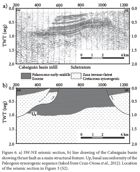
The Cabaiguán basin extends westward from the Central basin and onto the volcanic-sedimentary complex of the Zaza terrane. The basin has a longitudinal axis striking E-W (Figure 3). The latest Cretaceous synorogenic sequence is equivalent to those in the Central basin. The Tertiary sedimentary infill is constituted only by the Paleogene synorogenic sediments that exceed 1500 m in thickness in the eastern part of the basin, becoming thinner towards the west (Cruz-Orosa et al., 2012).
The boundary between the Cabaiguán and Central basins is not clearly defined, but is probably affected by faults (Cruz-Orosa et al., 2012). The basin is limited to the west by a SSE-NNW fault (Linares et al., 1985) and to the south by an E-W fault (Figure 3).
Cruz-Orosa et al. (2012) show an interpreted SW-NE seismic section located in the approximate center of the Cabaiguán basin (Figure 6). This section shows thrust faults and folding affecting the Paleocene to Early-Middle Eocene beds.
Elements of the petroleum system in central Cuba: Source rocks, reservoir and seals
Bahamas paleomargin carbonates are considered the main source rocks of the Cuban oil system (outcropping northward the study area, Figure 3). They are formed at deep-water with organic-rich carbonate mudstones (Upper Jurassic and Lower Cretaceous age). Geochemical analyses and sample interpretations confirm the oil and gas potential of this group of rocks (Maksimov et al., 1986; Lopez-Quintero et al., 1994; Lopez-Rivera et al., 2003a, 2003b; Moretti et al., 2003a, 2003b; López-Rivera and López-Quintero, 2004; Magnier et al., 2004; Domínguez and López-Quintero, 2005).
Even though Guayos and Catalina Formations are Upper Cretaceous, they show some evidence of source rocks (Navarrete-Reyes et al., 1994; Moretti et al., 2003b; Schenk, 2008). The Eloisa Formation (Upper Cretaceous) is constituted of oil reservoir conglomerate sections. At the Central basin, the Eloisa Formation has a considerable clay thickness that work like seal rocks (Álvarez-Castro, 1994). These three geological formations (Guayos, Catalina and Eloisa) are included in the Upper Cretaceous group of deep-water carbonate mudstones, also defined within the North Cuba Basin (Maksimov et al., 1986; Lopez-Quintero et al., 1994; Lopez-Rivera et al., 2003a, 2003b; Moretti et al., 2003a, 2003b; López-Rivera and López-Quintero, 2004; Magnier et al., 2004; Domínguez and López-Quintero, 2005).
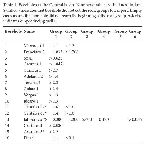
At the Central basin, various exploratory wells are located; some of them are productive in the Cristales and Pina oil fields (Figure 3; Table 1). All volcanic and sedimentary sequences (Upper Cretaceous to Eocene age), are potential reservoir rocks. Carbonated reservoirs not belonging to the paleomargin have been found at the Cristales oil field (Cristales 5, 57 and 63 boreholes). Volcano-sedimentary reservoirs are present in the Pina oil field (Figure 3; Table 1).
METHODOLOGY AND DATA
The inverse modeling is based on Gallardo et al. (2003, 2005) and was applied to different targets in Pérez-Flores et al. (2004) and Batista et al. (2007, 2012, 2013). With a set of vertical prisms, we simulate the upper and lower topography of a rock group. The goal of the inverse process is to estimate the depth to the upper and lower limit of each prism. We can simulate many rock groups with many sets of prisms pasted one over the other. In this way, the inverse process estimates the top and bottom 3D topography for every rock group. Gravity is sensitive to density contrasts, so we sometimes put together one or more vertically contiguous geological formations with similar densities and we call this a rock group. We assume the depths for every prism as unknown and density contrasts for every rock group as known. In order to reduce the inherent non-uniqueness of the gravity inverse problems, we add surface geology and borehole information as constraints. To introduce surface geology, the geological map is divided into cells of equal size, representing the upper limit of prisms (view Figure 3). Each of these prisms is assigned a rock group depending on the rock group that covers more space within the area occupied by the prism. If a deep rock group outcrops, the upper prisms collapses theirs thickness to zero. Borehole information is introduced by the depth where the borehole cuts the lower and upper part of every group, giving some uncertainty because the prism area is 3 km x 3 km and the borehole area is negligible in comparison.
The gravity data used in the 3D inversion were measured at 1:100, 000 scale (Figure 7; Ipatenko, 1968). The gravimetric survey contains 8,708 measured data, in an area of 8,577.88 km2 with an accuracy measured of 0.051 mGal.
In this study, a geological map at 1:500,000 scale was used (modified from Linares et al., 1985) as well as data from 16 boreholes (Table 1; Hatten et al., 1958; Sánchez-Arango, 1977; Linares, 1978; Millán, 1986; Álvarez-Castro, 1994; Blanco, 1999). Both sets of information contributed to the constraint of the 3D model. A flat topography was assumed in the model.
A physical-geological model is a simplification of the geological and physical characteristics of the investigated area. For this reason, despite the complex geology of the study area, especially at its NW limit (Figure 3), a model that included six rock groups was used (Table 2), classified by the densities and the stratigraphic positions of the geological formations. The volcanic rocks were subdivided into two groups, based on the results of Díaz de Villalvilla (1988). Group 1 includes all sedimentary rocks outcropping in the investigated area with age from Late Cretaceous (Campanian-Maastrichtian age) to Neogene. Group 2 contains Late Cretaceous volcanic rocks. Group 3 includes Late Jurassic to Early Cretaceous volcanic rocks (Zurrapandilla y Cabaiguán Fm.) and felsic intrusive rocks. Both levels of volcanic rocks (lower and upper) are different in densities because of the composition and so were separated into the two different groups 2 and 3. Ophiolitic rocks (basic and ultrabasic rocks) belong to the group 4. Group 5 comprises carbonate rocks of the Bahamas paleomargin. Group 6 includes metamorphic basement rocks.

In the study area 980 prisms were used for each of the six groups of rocks, i.e. 5,880 prisms in total. Figure 3 illustrates the assignment of every prism to a rock group. The first prisms (e.g. 1 to 242) were assigned to group 1, whereas that the prism 243 is assigned to group 3, the lower level of volcanic rocks.
The Jatibónico 78 borehole is the most informative for the 3D inversion process. This is located at the center of the Central basin and its depth exceeds 4 km with a larger thickness within Group 3. It also indicates the absence of paleomargin rocks.
The 3D inversion algorithm used tends to smooth the real tectonic deformation (folds and faults). Therefore, real deformations could be slightly larger than the present estimated ones.
DISCUSSION
Basins framework
After 10 iterations, gravity data and the model resembled each other very well (Figure 8). There is a loss of high frequency features on the gravity response because we are using prisms with 3 km x 3 km area. Data and response differences are plotted on Figure 8c. Figure 9 shows the bottom depth for every rock group and Figure 10 their thicknesses. For further information, we made nine cross-sections (five with N-S direction and four with E-W direction) over the resulting 3D model. Figure 8b shows the locations.
Gravity data and response resemble each other very well with 97.4 % fitting (Figures 8a and 8b), and their differences are almost random and averaging less than 2 mGals. Despite the inherent non-uniqueness, the surface geology and boreholes increase the geological certainty of the model.
Zero mGal isoline shows approximately the boundary between Central and Cabaiguán basins (Figures 8a and 8b). The Central and Cabaiguán basins look elongated. The first has SW-NE direction and the second E-W. Most of the area occupied by both basins corresponds to negative gravity values (Figure 8a). Gravity highs are observed suggesting structural highs. Some of these gravity highs are correlated with known wells (e.g. near Jatibónico 78 borehole; Figures 8 and 11). These gravity highs are of great interest for oil exploration.
Group 1 (sedimentary rocks) exceeds 5 km depth in the SW and S of the Central basin (letter A in Figure 9a), defining sub-basins located south of the Central basin (letter B in Figure 9a). These rocks deepen up to 2.5 km at the easternmost area of the Cabaiguán basin (letter C in Figure 9a). The depth variations of this group reveal the 3D geometry of the two basins (Central and Cabaiguán basins) and the structural high locations (letters D1 to D15 in Figure 9a). These structural highs cause the decrease in the depths of groups 3 and 4 and consequently generate gravity highs (Figure 11). Recent investigations on the Central basin reported stored oil and gas in the contact between Cretaceous tuff and sedimentary rocks (groups 1 and 2). The oil and gas stored in this contact justifies the importance of determining the bottom surface of the sedimentary rocks (group 1) and of defining such structural highs.
The basins' shape and boundaries are controlled by NE-SW and NW-SE faults (as seen on Figure 3). Both directions correspond with the directions of the main Cuban tectonic system (Puscharovsky et al., 1989). The bottom of group 2 (upper level of volcanic rocks) deepens 11 km at the southwestern end of the Central basin (letter E, at Figure 9b). Knowing the depth variations of the rock group is very important because such volcanic sequences may be potential reservoir rocks. Ophiolites and paleomargin carbonate rocks approach the surface defining structural highs (Figures 9c, 9d and 9e). Paleomargin rocks are located at 5 km depth in the vicinity of high Jatibónico (Jatibónico 78 well position). The larger thicknesses in group 2 are observed in both limits of Central basin (SW and NE) and westward Cabaiguán basin (Figure 10a). Paleomargin rocks increase their thickness at the northward end of Central basin (Figure 10d).
The basement relief of the Central and Cabaiguán basins is better observed through cross-sections (Figures 11 and 12). Those cross-sections also show the structural highs and the fault characteristics like shape, direction, depth and lithology affected by the tectonic. The characterization of these faults systems is very important, not only to assess the geological evolution of the study area, but also to determine the probable hydrocarbon migration paths.
The south limit of cross-section 1 (Figure 12) shows the geometry of the bottom of the sedimentary infill of the Central basin. This geometry is similar to that observed in the interpreted seismic section by Cruz-Orosa et al. (2012) (Figure 5).
The 3D isometric representation shows better the depth and thickness for every geologic group, underground faults and their projection on surface (Figure 13). This isometric representation also shows the basin shape and the structural highs.
It is interesting to see the correlation between some of the structural highs and productive wells (11, 12 and 15 borehole with the structural high D7, and the 16 borehole with the structural high D9; Figure 9).
The structural patterns identified in the proposed 3D density model help to know details of the petroleum system in the region, showing boundaries of basins and structural highs that could relate to possible oil traps. The model also suggests locations of fault systems that could act as migration pathways within the petroleum system.
Paleogeographical indicators
Large tectonic deformation is observed northward the Central and Cabaiguán basins, in which the majority of the rock groups described in the model are outcropping (Figure 3) or are relatively shallow (Cross-sections 1, 2 and 3 in Figures 11 and 12). Volcanic, ophiolitic and paleomargin thickness varies in the NW-SE direction (see Figures 10b, 10c and 10d), following one of the main faulting directions (Puscharovsky et al., 1989; Peña-Reyna et al., 2007). The large tectonic deformations described as well as the variations of thickness of the rocks groups following the faults system indicate the relationship of the analyzed rocks with collision and overthrust processes that occurred during the Late Cretaceous (Campanian-Maastrichtian) to Middle Eocene (Ross and Scotese, 1988; Pindell et al., 1988; Pindell, 1994; Mann et al., 1995).
The results of these processes are shown on the N-S and E-W cross-sections (Cross-sections 1 to 5, 8 and 9 in Figures 11 and 12). The cretaceous volcanic arc is over ophiolites and these two are overthrusting the Bahamas Paleomargin. Moreover, this whole collection of rocks is also overthrusting the metamorphic basement.
The southern limit of the area is characterized by layering rocks with minimal structural changes and few faults, while the north limit shows much folding and many faults indicating that the northern region was more affected by the collision process and overthrust (Figure 13).
The results shown in this section indicate that the proposed 3D density model describes the main geological events that affected the area. The model shows the distribution of the structural deformations caused by these events.
Location of structural highs and probable oil traps
Because petroleum might have migrated from the source rocks to traps in the thrust belt and in the foreland basin (Lopez-Rivera et al., 2003a, 2003b), we identified structures related to those traps in the Central and Cabaiguán basins. Both basins were initially defined and then structural highs were obtained from the cross-sections as well as depth and thickness for the rocks groups. These structural highs are very important targets for the petroleum industry.
We identified 11 structural highs at group 1 and inside the Central basin (D1 to D11; Figure 9a). It is important to emphasize that in the structural highs D7 and D9, producing wells have already been located (wells Cristales 5, 57 and 63 in D7; well Pina in D9). Highs in the Cabaiguán basin (D12) and Central basin SE border (D13, D14, D15) are also considered as potential well sites. We identified other structural highs and designated them with letter F in Figures 11 and 12.
Cross-sections 8 and 9 (Figure 11) show that the producing wells Cristales 5 (15) and Pina (16) are drilling inside their corresponding structural high related with faults. Drilling is cutting deeper faults that connect the source rocks with the traps. This suggests that most of the highs are very similar. We argue that other wells (e.g. Adelaida 2 (6) and Júcaro 1 (10); cross-section 3 in Figure 11 and cross-section 6 in Figure 12) are properly located over their highs, but they did not reach the fault zone or the contact sediments and volcanic rocks group and so are not oil productive. The model also shows some wells are misplaced (e.g. Galata 1 (8) in cross-sections 2 and 9; Figure 11), generally on synclinal zones, which was probably the cause of their unproductiveness.
The structural highs identified above indicate areas to be studied more in detail using 2D or 3D seismic methods. These areas have the possibility of approaching the contact between group 1 and 2 which is likely to accumulate oil and gas within these structures.
We also recommend seismic studies in the identified sub-basins to corroborate the proposed boundaries of both basins (Central and Cabaiguán basins).
CONCLUSIONS
The presented 3D density model of central Cuba proposes new characteristics on the structural deformation inside the Central Cuba area which are considered to have implications for the petroleum system characterization for the Central and Cabaiguán basins and understanding of the geological evolution of the area. These new characteristics are about the basins geometry and the location of structural highs and probable hydrocarbon traps. The model shows the variations of the depths and thicknesses of the lithological groups. Within such groups are the source and reservoir rocks of Cuban petroleum system at this region. The geologic group's 3D reliefs, the location and geometry of every single structural high were determined based on the inversion of the gravity anomaly as well as the location of the faults (view diagrams of depths, cross-sections and isometric diagram). We also located several sub-basins and deeper structural highs to the south of the Central basin, suggesting that these basin boundaries were displaced S-SW. The identified structural highs are constituted by sedimentary rocks, volcanic, ophiolitic and carbonate rocks of paleomargin. Some of these rocks are considered source rocks (carbonate rocks of paleomargin) and reservoir (sedimentary and volcanic rocks). These proposed new features, related to structural deformation, contribute to future hydrocarbon exploration in this region. Based on the results of the obtained 3D density model, we propose areas for further investigations, mainly on the structural highs. The collision and overthrust processes of the Caribbean and American plate occurred from the Upper Cretaceous (Campanian-Maastrichtian) to Middle Eocene and they are well recognized in the model by folding and faulting. These processes caused that some faults systems are now the basin boundaries but also the rising of the mentioned structural highs. The geometry of the lithological groups suggests that rocks located northward to the Central basin are most affected by the collision and overthrust processes. In general, the model describes the main geological events that affected the study area and shows the distribution of the main structural deformations caused by the collision and overthrust processes.
ACKNOWLEDGMENTS
We thank to Joaquín Proenza for suggestions that allowed improving this work. Financial support was granted to the principal author through a scholarship from CONACYT. We thank Thierry Calmus and an anonymous referee for their constructive comments that helped to improve the manuscript.
REFERENCES
Álvarez-Castro, J., 1994, Evaluación del potencial de exploración del bloque #21. Región noreste de la cuenca central: CUPET (Cuba-Petróleo), Majagua, Reporte técnico, 78 pp. [ Links ]
Batista, J., Pérez-Flores, M.A., Quiroga-Goode, G., Gallardo, L.A., 2007, Geometry of ophiolites in Eastern Cuba from 3D inversion of aeromagnetic data, constrained by surface geology: Geophysics, 72(3), May-June, B81-B91. [ Links ]
Batista, J., Blanco, J.A., Pérez-Flores, M.A., Rodríguez-Infante, A., 2012, Structures and petroleum prospects of the Saramaguacán basin, Cuba, from 3D inversion of gravimetric data: Geofísica Internacional, 51(1), 51-61. [ Links ]
Batista, J., Pérez-Flores, M.A., Urrutia-Fucugauchi, J., 2013, Three-dimensional gravity modeling of Chicxulub Crater structure, constrained with marine seismic data and land boreholes: Earth Planets Space, 65, 973-983. [ Links ]
Blanco, J., 1999, Stratigraphy and paleogeography of piggyback basins eastern center Cuba: Instituto Superior Minero Metalúrgico de Moa, Cuba, PhD thesis, 271 pp. [ Links ]
Blanco, J., Proenza, J., 2000, Sistematización tectonoestratigráfica de Cuba centro oriental: Minería y Geología 3(1), 35-45. [ Links ]
Cruz-Orosa, I., Blanco-Moreno, J.A., Vázquez-Taset, Y.M., 2007, Análisis estructural a escala regional de la zona de falla La Trocha: Minería y Geología, 23, 1-24. [ Links ]
Cruz-Orosa, I., Sàbat, F., Ramos, E., Vázquez-Taset, Y.M., 2012, Synorogenic basins od central Cuba and collision between the Caribbean and North America plates: International Geology Review, 54(8), 876-906. [ Links ]
Díaz de Villalvilla, L., 1988, Caracterización geológica y petrología de las asociaciones vulcanógenas del arco insular cretácico de Cuba Central: La Habana, Cuba, PhD thesis, 112 pp. [ Links ]
Domínguez, Z., López-Quintero, J.O., 2005, Geochemical characterization of crude Cubans: classification based on saturated biomarkers in III Brazilian Congress P & D in Oil and Gas, 9-14. [ Links ]
Draper, G., Barros, A., 1994, Chapter 4: Cuba, in Donovan, S.K., Jackson, T.A. (eds.), Caribbean Geology: An Introduction, University of the West Indies Publishers Association, University of the West Indies Press, Kingston, Jamaica, 65-86. [ Links ]
Gallardo, L. A., Pérez-Flores, M.A., Gómez-Treviño, E., 2003, A versatile algorithm for joint 3- D inversion of gravity and magnetic data: Geophysics, 3(68), 1-11. [ Links ]
Gallardo, L.A., Pérez-Flores, M.A., Gómez-Treviño, E., 2005, Refinement of three-dimensional multilayer models of basins and crustal environments by inversion of gravity and magnetic data: Tectonophysics, 397, 37-54. [ Links ]
García-Casco, A., Iturralde-Vinent, M.A., Pindell, J.L., 2008, Latest Cretaceous collision/accretion between the Caribbean Plate and Caribeana: Origin of metamorphic terranes in the Greater Antilles: International Geology Review, 50, 781-809. [ Links ]
Hatten, C., Schooler, O., Giedt, N., Meyerhoff, A., 1958, Geology of central Cuba, eastern Las Villas and western Camagüey provinces: National Bureau of Mineral Resources, La Habana. Unpublished report. [ Links ]
Iturralde-Vinent, M.A., 1994, Cuban geology: a new plate tectonic synthesis: Journal of Petroleum Geology, 17, 39-69. [ Links ]
Iturralde-Vinent, M.A., 2006, Meso-Cenozoic Caribbean paleogeography: Implications for the historical biogeography of the region: International Geology Review, 48, 791-827. [ Links ]
Ipatenko, S., 1968, Informe sobre las investigaciones variométricas y gravimétricas llevadas a cabo en la provincia de Camagüey. Empresa Nacional de Geofísica, Cuba, 309 pp. [ Links ]
Linares, E., 1978, Posibilidades gasopetrolíferas del horst Jatibónico-Rubio-Cometa, yacimiento Catalina en la depresión central cubana: ISMM de Moa, Cuba, PhD tesis, 178 pp. [ Links ]
Linares, E., Osadchiy, P.G., Dovbnia, A.V, Gil, S., García, D., García, L., Zuazo, A., González, R., Bello, V., Brito, A., Bush, W.A., Cabrera, M., Capote, C., Cobiella, J.l., Díaz de Villalvilla, L., Eguipko, O.I., Evdokimov, Y.B., Fonseca, E., Furrazola, G., Hernández, J., Judoley, C.M., Kondakov, L.A., Markovskiy, B.A., Norman, A., Pérez, M., Peñalver, L., Tijomirov, I.N., Trofimov, V.A., Vtulochkin, A.L., Vergara, F., Zagoskin, A.M., Zelepuguin, V.N., 1985, Mapa geológico de la República de Cuba, 1: 500 000. [ Links ]
Lopez-Quintero, J.O., Campos-Jorge, P.G., Navarrete-Reyes, L.E., Principe Valdes, M.L., 1994, Cuban source rocks, in Mello, M.R., Trinidade, L.A.F., Hessel, M.H.R. (eds.): Bucaramanga, Colombia, Fourth Latin American Congress on Organic Geochemistry, Extended abstracts volume, 102-108. [ Links ]
López-Rivera, J.G., López-Quintero, J.O., 2004, The Main Scenarios for Petroleum Exploration in the Southeastern Part of the Gulf of Mexico, in AAPG International Conference. Mexico, p1. [ Links ]
Lopez-Rivera, J.G., Lopez-Quintero, J.O., Dominquez, B.R., Toucet, S., 2003a, Petroleum geology characterization and oil potential in the southwestern sector of the Cuban Exclusive Economic Zone (CEEZ) in the Gulf of Mexico (abstract), in Barcelona, Spain, American Association of Petroleum Geologists International Meeting, Official program book, pp. A56 (Poster summary provided at Conference). [ Links ]
Lopez-Rivera, J.G., Lopez-Quintero, J.O., Moretti, I., 2003b, Sistemas petroleros del sureste del Golfo de México y su geohistoria, en II Taller Internacional Sobre Geología y Potencial Petrolero del Golfo de México (Aguas Profundas), Habana, Cuba, one CD-ROM, 53-58. [ Links ]
Magnier, C., Moretti, A.I., Lopez-Quintero, J.O., Gaumet, F., Lopez, J.G., Letouzey, J., 2004, Geochemical characterization of source rocks, crude oils and gases of Northwest Cuba: Marine and Petroleum Geology, 21(2), 195-214. [ Links ]
Mann, P., Taylor, F., Lawrence, E., Ku, T., 1995, Actively evolving microplate formation by oblique collision and sideway motion along strike-slip faults: An example from the northeastern Caribbean plate margin: Tectonophysics, 246, 1-69. [ Links ]
Maksimov, S.P., Botneva, T.A., Pankina, R.G., Kleshchev, K.A., Shein, V.S., Yparraguirre, H., Lopez, H.O., 1986, Genetic oil types in the petroliferous basins of Cuba: International Geology Review, 28, 704-710. [ Links ]
Meyerhoff, A.A., Hatten, C.W., 1968, Diapiric structure in central Cuba: AAPG Memoir, 8, 315-357. [ Links ]
Meyerhoff, A.A., Hatten, C.W., 1974, Bahamas salient of North America: Tectonic framework, stratigraphy and petroleum potential: AAPG Bulletin, 58, 1201-1239. [ Links ]
Millán, G., 1986, Estratigrafía del área Catalina, Cueca Central de Cuba, basado en datos del subsuelo: Serie Geológica, 1, 18-30. [ Links ]
Moretti, I., Tenreyro-Perez, R., Linares, E., Lopez, J.G., Letouzey, J., Magnier, C., 2003a, Petroleum systems of the Cuban north-west offshore (abstract), in Havana, Cuba, Fifth Cuban Congress on Geology and Mineralogy, 62. [ Links ]
Moretti, I., Tenreyro, R., Linares, E., Lopez, J.G., Letouzey, J., Magnier, C., Gaumet, F., Lecomte, J.C., Lopez, J.O., Zimine, S., 2003b, Petroleum system of the Cuban northwest offshore zone, in Bartolini, C., Buffler, R.T., Blickwede, J.F., eds., The Circum-Gulf of Mexico and the Caribbean-Hydrocarbon habitats, basin formation, and plate tectonics: Tulsa, Okla., American Association of Petroleum Geologists Memoir 79, chap. 31, 125-128. [ Links ]
Navarrete-Reyes, L.E., Campos-Jorge, P.G., Lopez-Quintero, J.O., 1994, Depositional environments of Cuban oils determined by biological markers, in Mello, M.R., Trinidade, L.A.F., Hessel, M.H.R., (eds.), Fourth Latin American Congress on Organic Geochemistry: Bucaramanga, Colombia, Extended abstracts volume, 122-128. [ Links ]
Pardo, G., 1975, Geology of Cuba, in Nairn A.E.M., Stehli, F.G., (eds.), The ocean basins and margins, Volume 3, The Gulf of Mexico and the Caribbean: New York, Plenum, 553-615. [ Links ]
Pérez-Flores, M.A., Suárez-Vidal, F., Gallardo, L.A., González, A., Vázquez, R., 2004, Structural pattern of the Todos Santos Coastal Plain, based on geophysical data: Ciencias Marinas, 30(2), 349-364. [ Links ]
Peña-Reyna, A., Batista, J., Blanco, J., 2007, Nuevas regularidades estructurales de la Cuenca Central (Cuba) a partir de la interpretación cualitativa de datos gravimétricos: Minería y Geología, 23(1), 1-19. [ Links ]
Pindell, J.L., 1994, Evolution of the Gulf of Mexico and the Caribbean, in Donovan, S.K., Jackson, T.A. (eds.), Caribbean Geology: An Introduction, 13-39, University of the West Indies Publisher's Association, Kingston, Jamaica. QE 220 C34 1994. [ Links ]
Pindell, J.L., Dewey, J.F., 1982, Permo-Triassic reconstruction of western Pangea and the evolution of the Gulf of Mexico/Caribbean region: Tectonics, 1, 179-211. [ Links ]
Pindell, J.L., Cande, S., Pitman III, W.C., Rowley, D.B., Dewey, J.F., LaBrecque, J., Haxby, W., 1988, A plate-kinematic framework for models of Caribbean evolution: Tectonophysics, 155, 121-138. [ Links ]
Pindell, J.L., Kennan, L., Maresch, W.V., Stanek, K.P., Draper, G., 2006, Foundations of Gulf of Mexico and Caribbean evolution: Eight controversies resolved: Geologica Acta, 4, 303-341. [ Links ]
Pszczolkowski, A., Myczynski, R., 2003, Stratigraphic constraints on the Late Jurassic-Cretaceous paleotectonic interpretations of the Placetas belt in Cuba, in Bartolini, C., Buffler, R.T., Blickwede, J., (eds.), The circum-Gulf of Mexico and the Caribbean: Hydrocarbon habitats, basin formation, and the plate tectonics: AAPG Memoir, 79, 545-581. [ Links ]
Pszczolkowski, A., Myczynski, R., 2010, Tithonian- Early Valanginian evolution of deposition along the proto-Caribbean margin of North America recorded in Guaniguanico successions (western Cuba): Journal of South American Earth Sciences, 29, 225-253. [ Links ]
Puscharovsky, Y. M., Mossakovskiy, A.A., Suárez, J., 1989, Tectonic map of Cuba at 1:500 000 (4 sheets): Academy of Sciences of Cuba, Institute of Geology and Paleontology and Academy of Sciences of the USSR, Moscow. [ Links ]
Rosencrantz, E., Pardo, G, 1993, An overview of the Cuban Orogen, with an assessment of hydrocarbons potential: Austin, TX, University of Texas Institute for Geophysics, Technical Report No. 130. 47 pp. [ Links ]
Ross, M.I., Scotese, C.R., 1988, A hierarchical tectonic model of the Gulf of Mexico and Caribbean region: Tectonophysics, 155, 139-168. [ Links ]
Sánchez-Arango, J., 1977, Estudio bioestratigráfico del pozo Catalina #5: Minería en Cuba, 3(4), 15-26. [ Links ]
Saura, E., Vergés, J., Brown, D., Lukito, P., Soriano, S., Torrescusa, S., García, R., Sánchez, J.R., Sosa, C., Tenreyro, R., 2008, Structural and tectonic evolution of western Cuba fold and thrust belt: Tectonics, 27, TC4002. Doi: 10.1029/2007TC002237, 1-22. [ Links ]
Schenk, C. J., 2008, Jurassic-Cretaceous Composite Total Petroleum System and geologic models for oil and gas assessment of the North Cuba Basin, Cuba, in U.S. Geological Survey North Cuba Basin Assessment Team, Jurassic-Cretaceous Composite Total Petroleum System and geologic assessment of oil and gas resources of the North Cuba Basin, Cuba: U.S. Geological Survey Digital Data Series DDS-69-M, chap. 2, 94 pp. [ Links ]
Van Benthem, S., Govers, R. Wortel, R., 2014, What drives microplate motion and deformation in the northeastern Caribbean plate boundary region?: Tectonics, 33, 850-873. [ Links ]

