


Servicios Personalizados
Revista

Articulo
 Inglés (pdf)
 Artículo en XML
 Referencias del artículo
 Enviar artículo por email
Indicadores
 Citado por SciELO
 Links relacionados
-
 Similares en
SciELO
Similares en
SciELO
Compartir

 Permalink
Revista mexicana de ciencias geológicas
versión On-line ISSN 2007-2902versión impresa ISSN 1026-8774
Rev. mex. cienc. geol vol.27 no.3 Ciudad de México dic. 2010
Stratigraphic redefinition of the Zihuatanejo area, southwestern Mexico
Redefinición estratigráfica del área de Zihuatanejo, suroeste de México
Michelangelo Martini1*, Luca Ferrari2, Margarita López–Martínez3, and Victor Valencia4
1 Instituto de Geología, Universidad Nacional Autónoma de México, Ciudad Universitaria, México D.F. 04510, México. *Correo electrónico: mmartini@geologia.unam.mx
2 Centro de Geociencias, Universidad Nacional Autónoma de México, Campus Juriquilla, Blvd. Juriquilla 3001, 76230, Querétaro, México.
3 Laboratorio de Geocronología, División de Ciencias de la Tierra, CICESE, Carr. Ensenada–Tijuana 3918, 22860 Ensenada, Baja California, México.
4Department of Geosciences, University of Arizona, Tucson, Arizona 85721, USA. Present adress: Geoservices, 3389 NRiver Rapids Dr., Tucson, 85712, Arizona, USA.
Manuscript received: February 22, 2010.
Corrected manuscript received: August 3, 2010.
Manuscript accepted: August 13, 2010
ABSTRACT
The Mesozoic volcano–sedimentary successions exposed in southwestern Mexico have been traditionally grouped into the Guerrero terrane, and interpreted to represent an allochthonous long–lived island arc or a complex multi–arc system accreted to the continental margin of North America. However, the nature of these arcs (intraoceanic versus continental), as well as the timing of the supposed accretion, are still debated. One of the key regions in this debate is that of Zihuatanejo, where a Cretaceous island arc (Zihuatanejo arc) and associated accretionary complex (Las Ollas Complex) have been defined in the past. In this paper we present a redefinition of the stratigraphy of the Zihuatanejo region, based on field mapping supported by new 40Ar/39Ar and U–Pb geochronology, which has significant implications for the Cretaceous–Paleogene evolution of the Guerrero terrane. The lowermost stratigraphic levels of the Zihuatanejo region are represented by the pre–Cretaceous polydeformed and partly metamorphosed rocks of the Las Ollas Complex and Lagunillas Formation. These rocks are unconformably overlain by the Early Cretaceous shallow marine Playa Hermosa arc assemblage. Volcanic rocks of this assemblage are restricted to a few meters ofandesitic lavas interbedded with volcaniclastic sandstone and limestone, which suggests that the study area was in a peripheral position with respect to the main axis ofa magmatic arc. The rocks of the Playa Hermosa assemblage were uplifted by folding, eroded, and unconformably overlain by Upper Cretaceous continental to shallow marine rocks of the La Unión–Zihuatanejo assemblage, which are only gently folded. Similar continental rocks (Cutzamala Formation) are exposed in the Huetamo area, ~80 km northeast of Zihuatanejo, and are interpreted as overlapping successions of the Guerrero terrane. Based on this correlation, we propose that the Upper Cretaceous La Unión–Zihuatanejo assemblage is not part of the tectono–stratigraphic Guerrero terrane but rather constitute an overlap succession that post–dates the possible accretion of this terrane to nuclear Mexico. Finally, the Mesozoic rocks of the Zihuatanejo area are intruded by 48–40 Ma granitoids, and unconformably overlain by 41–39 Ma horizontally bedded volcanic and volcaniclastic rocks, which post–date the final contractile deformation in the Zihuatanejo area.
Key words: stratigraphy, Guerrero terrane, La Unión–Zihuatanejo assemblage, Zihuatanejo, Mexico.
RESUMEN
Las sucesiones volcanosedimentarias mesozoicas expuestas en el suroeste de Mexico han sido tradicionalmente agrupadas en el terreno compuesto Guerrero e interpretadas como productos de uno o más arcos insulares acrecionados a la margen continental de Norteamérica. Sin embargo, la naturaleza de estos arcos (intraoceánicos o continentales), así como la edad de la supuesta acreción siguen siendo debatidos. Una de las regiones cruciales para la definición del terreno Guerrero es la de Zihuatanejo, donde se ha propuesto la existencia de un arco insular marino del Cretácico Inferior (arco Zihuatanejo) asociado a un complejo de subducción (Complejo Las Ollas). En este trabajo presentamos una redefinición de la estratigrafía de la región de Zihuatanejo basada en una cartografía geológica detallada apoyada por nuevas edades 40Ar/39Ar y U–Pb, que implica cambios importantes para la evolución cretácico–paleógena del terreno Guerrero. En el área de Zihuatanejo, la base de la sucesión estratigráfica es constituida por rocas precretácicas polideformadas y parcialmente metamorfoseadas del Complejo Las Ollas y de la Formación Lagunillas. Estas rocas están cubiertas en discordancia por el conjunto Playa Hermosa, una sucesión marina somera del Cretácico Inferior. Las rocas volcánicas en este conjunto están limitadas a unos pocos metros de lavas andesíticas que se intercalan con areniscas volcánicas y calizas. Esto sugiere que la región de Zihuatanejo se encontraba en la zona periférica de un arco insular durante este periodo. Las rocas del conjunto Playa Hermosa fueron plegadas y levantadas, erosionadas y posteriormente cubiertas en discordancia por las rocas del conjunto La Unión–Zihuatanejo, el cual se encuentra sólo moderadamente plegado. Este conjunto es compuesto por una secuencia de ambiente continental a marino somero del Cretácico Superior. Sucesiones continentales similares a la del conjunto La Unión–Zihuatanejo se encuentran expuestas en la región de Huetamo, ~80 km al noroeste de Zihuatanejo, y han sido interpretadas como sucesiones de traslape del terreno Guerrero. Con base en esta correlación sugerimos que el conjunto La Unión–Zihuatanejo no es parte del terreno Guerrero sino constituye una secuencia de traslape que posdata su posible acreción al continente. Las rocas mesozoicas de Zihuatanejo son intrusionadas por granitoides con edades de 48 a 40 Ma, y están cubiertas en discordancia por una sucesión de rocas volcánicas y volcaniclasticas con edades entre 41 y 39 Ma que posdatan la deformación contráctil.
Palabras clave: estratigrafía, terreno Guerrero, conjunto La Unión–Zihuatanejo, Zihuatanejo, México.
INTRODUCTION
The Mesozoic volcano–sedimentary successions exposed in southwestern Mexico have been traditionally grouped into the Guerrero composite terrane (Campa and Coney, 1983), consisting, from west to east, of the Zihuatanejo, Arcelia, and Teloloapan terranes (Talavera–Mendoza et al., 2007) (Figure 1a). The paleogeography and geodynamic evolution of the Guerrero terrane has been a matter of debate during the last three decades (e.g., Tardy et al., 1994; Cabral–Cano et al., 2000; Elías–Herrera et al., 2000; Dickinson and Lawton, 2001; Talavera–Mendoza et al., 2007; Martini et al., 2009). Some authors interpreted these successions in terms of an allochthonous intraoceanic arc or multi–arc system formed in the paleo–Pacific domain, which was subsequently accreted to North America as a result of the subduction and closure of an oceanic basin (e.g., Tardy et al., 1994; Dickinson and Lawton, 2001; Keppie, 2004; Talavera–Mendoza et al., 2007) (Figure 1b). These allochthonous scenarios display large variations in the paleogeography, vergence of the subduction, and timing of accretion. Some authors have considered that the Guerrero terrane accreted during the latest Cretaceous – early Paleogene, triggering the Laramide deformation across the Mexican Pacific margin (e.g., Salinas–Prieto et al., 2000; Keppie, 2004; Talavera–Mendoza et al., 2007). Others proposed that the Guerrero accretion occurred during the late Early Cretaceous, before the development of the widespread Aptian–Cenomanian carbonate platform and reefal patches in southern Mexico (e.g., Tardy et al., 1994; Dickinson and Lawton, 2001). Alternatively, other authors favor the idea that the Guerrero terrane is composed of autochthonous or para–autochthonous successions developed above the extensionally thinned continental margin of Mexico (e.g., Lang et al., 1996; Cabral–Cano et al., 2000; Elías–Herrera et al., 2000; Martini et al., 2009) (Figure 1b). These contrasting models likely arise because detailed studies on the stratigraphy and deformation of the Mesozoic rocks of the Guerrero terrane are still scarce and limited to only a few localities (e.g., Elías–Herrera et al., 2000; Salinas–Prieto et al., 2000; Talavera–Mendoza et al., 2007; Martini et al., 2009). An important advance in the tectono–stratigraphic definition of the Guerrero terrane constituted the recognition that widespread Santonian– Maastrichtian continental rocks, previously considered part of this terrane, unconformably overlie the Zihuatanejo–Arcelia terrane boundary, and thus represent overlap successions that post–date the proposed terrane accretion (Centeno–García et al., 2008). In view of these data, a tectono–stratigraphic review of the Guerrero terrane is necessary in order to reconstruct more coherently the complex paleogeography of southwestern Mexico during the Mesozoic.
In this paper we present new stratigraphic data supported by 40Ar/39Ar and U–Pb ages for the Zihuatanejo region (Figure 1a). We do not intend to propose a comprehensive paleogeography or a geodynamic model for southwestern Mexico. However, the new data presented in this paper imply a revision of critical aspects of the statigraphy of the Guerrero terrane. In particular, we show that rocks previously considered part of the Guerrero terrane are actually overlap successions post–dating the Guerrero terrane possible accretion to nuclear Mexico. A study on the deformation phases affecting the Zihuatanejo region and their relation to the Laramide orogeny is presented in a companion paper (Martini and Ferrari, submitted).
PREVIOUS STRATIGRAPHY OF THE ZIHUATANEJO REGION
A regional synthesis of the stratigraphy and tectonic interpretations of the Zihuatanejo, Arcelia, and Teloloapan terranes has been presented in a recent work by Centeno–García et al. (2008). In Figure 2 and Table 1 we summarize only the relevant stratigraphic data presented in previous works for the Zihuatanejo terrane and present a comparison between them and the new stratigraphy proposed in this work.
Preliminary descriptions of the Zihuatanejo stratigraphy defined the Zihuatanejo Formation and the Las Ollas Complex (Vidal–Serratos, 1986; Talavera–Mendoza and Guerrero–Suástegui, 2000). The former was described as a 1,500 m–thick succession of andesite to dacite lava flows and volcaniclastic turbidites, interpreted to represent an intraoceanic arc (Vidal–Serratos, 1986; Talavera–Mendoza and Guerrero–Suástegui, 2000), capped by Albian limestone (Ixtapa member, Vidal–Serratos, 1986) interstratified with red beds (La Unión member, Vidal–Serratos, 1986) (Figure 2 and Table 1). Additionally, Vidal–Serratos (1986) recognized a succession of conglomerate and sandstone (Posquelite member) at the base of the Zihuatanejo Formation (Figure 2 and Table 1). The conglomerate is composed of clasts of deformed two–mica metagranite, quartzite, and gneiss (Vidal–Serratos, 1991). Similarly, Centeno–García et al. (2003) interpreted the Zihuatanejo Formation as an arc succession composed of andesitic lava flows, tuff and shallow marine volcaniclastic turbidite–like deposits. However, these authors pointed out that these rocks apparently overlie the Albian limestone of the Ixtapa member, and not vice versa as previously proposed. More recently, a main peak age at 85 Ma was reported for detrital zircons from a sandstone of the Zihuatanejo Formation (Talavera–Mendoza et al., 2007), which confirmed that these rocks are younger than the Albian carbonate strata. Previous authors inferred that the Zihuatanejo Formation is thrust over the Las Ollas Complex (Vidal–Serratos, 1986; Talavera–Mendoza, 2000), which consists of quartz–rich metaturbidites, locally containing blocks and slabs of pillow basalt, banded gabbro, amphibolite, chert, limestone, quartzite, tuff and partly to wholly serpentinized ultramafic rocks (Vidal–Serratos, 1986; Talavera–Mendoza, 2000). Talavera–Mendoza (2000) also reported a blueschist paragenesis for these rocks at Puerto Vicente Guerrero (Figure 1a), indicating P–T conditions of 5–7 kbars and 200–330 °C. Based on the block–in–matrix structure, the geochemistry of the mafic blocks and the blue–schist metamorphism, Talavera–Mendoza (2000) interpreted these rocks as the accretionary prism of the Cretaceous Zihuatanejo intraoceanic arc. However, the youngest U–Pb ages of detrital zircons from the Las Ollas metaturbidites are ~376 Ma (Talavera–Mendoza et al., 2007), implying that the Las Ollas Complex is much older than the Cretaceous Zihuatanejo Formation. Similar polideformed greenschist to amphibolite metamorphic rocks, which enclose blocks of pillow basalt, banded gabbro, chert, and limestone, have been grouped into the Arteaga Complex by Centeno–García et al. (1993). This complex is exposed in the Arteaga region, ~60 km NW of study area (Figure 1a), and has been interpreted as an Upper Triassic accretionary prism, constituting the basement of the Zihuatanejo terrane (Centeno–García et al., 1993; Centeno–García et al., 2008).
Finally, scattered exposures of sandstone and shale with abundant detrital muscovite have been assigned by Vidal–Serratos (1986) to the Lagunillas Formation. However, is not clear if these rocks belong to the Las Ollas Complex or they are part of the Cretaceous arc succession. In spite of these apparent inconsistencies and complexities, the stratigraphy of the Zihuatanejo area has not been revised since its original definition.
METHODOLOGY
The geological mapping of four 1:50,000 scale topographic maps (E14–4 A81 and E14–10 C11, C12, C22) published by the Instituto Nacional de Estadística y Geografía (INEGI), was carried out through several months of field–work. Geologic cartography was integrated with the interpretation of Landsat Thematic Mapper images and 1:75,000 scale aerial photos.
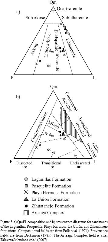
The composition of 19 samples of sandstone from different formations was determined by the Gazzi–Dickinson point–counting method, according to Dickinson (1970). Five hundred points were counted for each sample and the compositions are described in detail in the following section. The point–counting proportions and the recalculated parameters are presented in Table 2.
Two samples of volcanic rocks were analyzed by the 40Ar/39Ar method. A whole rock and a plagioclase–rich groundmass concentrate were irradiated in the uranium enriched research reactor of McMaster University in Hamilton (Ontario, Canada). The argon isotopic analysis was performed at the geochronologic lab of Centro de Investigación Científica y Educación Superior de Ensenada (CICESE), using both a MS–10 and a VG5400 mass spectrometers. The sample analyzed with the MS–10 was step–heated with a double wall Modifications Ltd Ta furnace, while in the experiments performed with the VG5400 mass spectrometer the argon extraction line uses a Coherent Innova 70C argon–ion laser to heat the sample. The age spectra, 37ArCa/39ArK vs 39Ar, and 36Ar/40Ar vs 39Ar/40Ar correlation diagrams, are given in the Geochronology section. Errors are reported at 1 –sigma level for all samples. Details of the experiments are shown in Table A1 of the electronic supplement. The argon isotopes were corrected for discrimination, blank, decay of 37Ar and 39Ar and interference contributions of argon isotopes derived from Ca, Cl and K. The decay constants recommended by Steiger and Jäger (1977) were used in the age calculations. All linear regressions were performed with the equations presented by York et al. (2004).
Zircons separated from three samples of intrusive rocks were dated by the U–Pb method. Mineral separation was carried out at the mineral separation facility of Centro de Geociencias, Universidad Nacional Autónoma de México (UNAM). To assist interpretation, zircons were observed and imaged under cathodoluminescence, using an ELM3R luminoscope connected to a digital camera. Individual zircon ages of the three intrusive rocks (samples MIKE 14–1–1, MIKE 11–1–3, and MIKE 23–1–2) were obtained by laser ablation multicollector inductively coupled plasma mass spectrometry (LA–MC–ICPMS) at the Laser Chron Center of the University of Arizona (Tucson). Ablation of zircons was performed with a New Wave/Lambda Physik DUV193 Excimer laser, operating at a wavelength of 193 nm, using a spot diameter of 35 microns for samples MIKE 14–1–1 and MIKE 23–1–2 and of 50 microns for sample MIKE 11–1–3. Common Pb correction is accomplished by using the measured 204Pb, and assuming an initial Pb composition from Stacey and Kramers (1975). Measurements of 204Pb are unaffected by the presence of 204Hg, because backgrounds are measured on peaks, and because very little Hg is present in the argon gas (Gehrels et al., 2008). Errors are reported to the 2–sigma level for all samples. Details of the experiments are presented in the Geochronology section 5 in Table A2 of the electronic supplement. The time scale reference of Walker and Geissman (2009) is adopted in this work.
Concentration of major and trace elements have been estimated for six samples of intrusive and five samples of volcanic rocks. Major elements were determined by X–ray fluorescence spectroscopy (XRF) using a Siemens SRS–3000 instrument in the Laboratorio Universitario de Geoquímica Isotópica (LUGIS), UNAM, using procedures of Lozano–Santa Cruz et al. (1995) and Verma et al. (1996). Trace element concentrations were obtained by inductively coupled plasma mass spectrometry (ICP–MS) at the Centro de Geociencias of Juriquilla, UNAM, using a Thermo Series Xii instrument, and procedure of Mori et al. (2007). Details of the measurements are given in the following section and in Table A3 of the electronic supplement.
STRATIGRAPHIC REDEFINITION OF THE ZIHUATANEJO AREA
We studied the area between the small town of Feliciano and the city of Zihuatanejo, in the eastern Michoacán and western Guerrero states (Figures 3 and 4). Based on field observation and the geometric relationships, we subdivide the Mesozoic and Cenozoic rocks of this region into three Cretaceous to Paleogene tectono stratigraphic assemblages, which unconformably overlie an undifferentiated pre–Cretaceous basement. We maintain when possible the names of the units proposed by previous authors. In the following we present a lithologic description of the stratigraphic units identified in this region, from the base to the top. A comparison between the previous stratigraphy and the new one proposed in this paper is given in Figure 2.
Pre–Cretaceous basement rocks
The oldest rocks exposed in the study area include the Las Ollas Complex and the Lagunillas Formation. These rocks display the same structural style and were intensely shortened and partly metamorphosed prior to the deposition of the Cretaceous–Paleogene tectono–stratigraphic assemblages. Therefore, they represent the basement on which the Cretaceous and Paleogene volcano–sedimentary successions developed. The Las Ollas Complex and the Lagunillas Formation are undifferentiated in the geologic maps of Figures 3 and 4, because a detailed stratigraphy and petrographic analysis of these rocks is beyond the scope of this work.
The Las Ollas Complex consists of a pile of tectonic nappes, which vary in size from the decameter to the kilometer scale. The lowermost structural levels are exposed at the cores of kilometric–scale anticlines and are composed of amphibolite schist finely interlayered with phyllite, quartzite, and scarce metatuff. Amphibolite schists are constituted by nematoblastic layers of green hornblende + titanite ± biotite ± oxides alternating with granoblastic layers of quartz ± muscovite. Amphibolites are overthrusted by greenschist to low greenschist metamorphic rocks, represented by actinolite schists finely interlayered with quartzite and phyllite. The former are composed by millimeter to centimeter nematoblastic levels of actinolite + titanite ± chlorite finely alternating with granoblastic levels of quartz ± muscovite. Metasedimentary rocks of the Las Ollas Complex enclose exotic blocks of banded metagabbro, amphibolite, serpentinite, metabasalt, dunite, plagiogranite, and quartzite, which vary in size from the decimeter to the kilometer scale. In the study area we did not find the blueschist paragenesis reported by Talavera–Mendoza (2000), perhaps due to pervasive retrograde metamorphism associated with the exhumation of these nappes. The metamorphic rocks of the Las Ollas Complex experienced polyphasic shortening, with a first NW–SE trending isoclinal folding that is not recorded in the overlying Cretaceous–Paleogene tectono–stratigraphic assemblages (Martini and Ferrari, submitted).
Rocks of the Lagunillas Formation were not differentiated from the Las Ollas Complex during mapping (Figures 3 and 4). The contact between the Lagunillas Formation and the metamorphic rocks of the Las Ollas Complex is not exposed in the study area. The Lagunillas Formation is composed of a rhythmic succession of finely bedded sandstone, shale, and scarce conglomerate, which is cut by several metric to decimetric sand dikes. Sandstones are fine– to coarse–grained, subangular to rounded, well sorted litharenites, which plot in the continental recycled field of the QmFL composition diagram (Figure 5). They are composed dominantly of mono– and polycrystalline quartz and detrital muscovite. Less amounts of lithics of chert, felsic intrusive, well foliated quartzite, quartz–muscovite schist, and phyllite are also present (see Table 2 for modal proportions). Conglomerates are matrix– to clast–supported, rounded to subangular, moderately sorted, and are made up of pebbles and cobbles of quartzite, foliated quartz–muscovite schist, and chert. Ripple marks, normal grading, and decimeter–scale channel–fill structures are locally observed in these rocks. Similar to the Las Ollas Complex, the sedimentary rocks of the Lagunillas Formation display NW–SE
Playa Hermosa assemblage
Rocks of this tectono–stratigraphic assemblage are exposed along a restricted NW–SE belt adjacent to the coast (Figure 3). They overlie unconformably the Las Ollas Complex and Lagunillas Formation, and display only NW–SE trending upright open folds. We subdivide the rocks of this assemblage into three different formations, which are, from the base to the top: the Posquelite, Playa Hermosa, and Ixtapa formations.
Posquelite Formation
Exposures of these rocks are restricted to a small area located 1 km NE of the Posquelite village (Figure 4b). This formation overlies the Las Ollas Complex; however, the contact is not clearly exposed in this area. The Posquelite Formation consists of ~100 m of polymictic conglomerate, rhythmically alternated with sandstone. Conglomerates are massive, matrix–supported, very poorly sorted, and are composed of angular to subrounded pebbles and cobbles of deformed two–mica metagranite, quartzite, gneiss, and polideformed amphibolite schists, which show a tightly folded foliation. Sandstones are partly recrystallized, probably because of the contact metamorphism induced by the nearby Eocene intrusions, which produced the crystallization of neoblasts of biotite + actinolite + quartz ± epidote. Less recrystallized parts show relics of the original composition and texture. Sandstones are fine– to medium–grained, angular to subangular, poorly sorted litharenites, which plot in the continental recycled field of the QmFL composition diagram (Figure 5). They are composed mostly of mono– and polycrystalline quartz. Less amounts of detrital muscovite, feldspar, and lithics of chert, quartz–rich sandstone, felsic intrusive, foliated quartzite, and quartz–muscovite schist are also observed (see Table 2 for modal proportions).
Playa Hermosa Formation
The Playa Hermosa Formation is exposed between the homonymous beach and the villages of Posquelite and La Salitrera, directly NW of Zihuatanejo (Figure 4b). In the Posquelite area, the Playa Hermosa Formation conformably overlies the Posquelite Formation. Nevertheless, in the surroundings of the village of La Salitrera, the Playa Hermosa Formation unconformably overlies the metamorphic rocks of the Las Ollas Complex (Figure 4b). Excellent exposures of this contact are present along a new roadcut near the village of La Salitrera. Here, the metamorphic polideformed rocks of the Las Ollas Complex are unconformably overlain by a ~3 m–thick conglomerate with boulders and cobbles of phyllite and actinolite schist, which are in turn overlain by the sedimentary rocks of the Playa Hermosa Formation, which display only NW–SE trending upright open folds. Scattered outcrops of the Playa Hermosa Formation are also exposed in the surroundings of the Troncones beach (Figure 3), where it unconformably overlies the polideformed rocks of the Lagunillas Formation. The Playa Hermosa Formation consists of sandstone, intercalated with uncommon conglomerate, and subordinate lava flows at the uppermost stratigraphic levels. Sandstones are fine– to coarse–grained, subangular, poorly sorted lithic arkoses, which plot in the transitional arc field of the QmFL composition diagram (Figure 5). They are composed of plagioclase, mono– and polycrystalline quartz, lithics of plagioclase phyric to micro–lithic mafic to intermediate lavas, and subordinate fragments of quartz plagioclase–phyric lava (see Table 2 for modal proportions). Conglomerates are mostly clast supported, poorly to moderately sorted, composed of subangular to subrounded pebbles of plagioclase–phyric lava, subordinate quartz–rich sandstone, and scarce andesitic outsize cobbles. Normal grading and clast imbrication are commonly observed in these rocks. Lava flows are restricted to the top of the Playa Hermosa Formation, where a 7 m–thick aphyric to plagioclase–phyric andesite flow caps the volcaniclastic rocks. Andesite display a vertical to subvertical axial plane cleavage, pervasive at the decimetric scale. The N–MORB normalized multi–element pattern for one sample of the andesite is characterized by the enrichment of the large ionic lithophile elements (LILE) relative to the high field strength elements (HFSE), and by pronounced negative Nb–Ta and Ti anomalies (Figure 6). Similarly, light rare earth elements (LREE) are enriched with respect to heavy rare earth elements (HREE) (La/Yb = 4.86), pointing to a typical supra subduction volcanic association (McCulloch and Gamble, 1991). The sedimentary and volcanic rocks of the Playa Hermosa Formation were affected by moderate to pervasive recrystallization and silicification, likely related to contact metamorphism induced by the nearby Eocene batholiths. Thermal effects produced the crystallization of biotite + actinolite + quartz ± epidote. As a result of the re–crystallization, sedimentary structures are rarely preserved. Bedding is recognizable only away from the contact with the intrusives. The thickness of this formation is strongly variable from a maximum of 1,000 m between the Playa Hermosa beach and the Posquelite village, to 0–40 m in the La Salitrera–Pantla region (Figure 4b), suggesting an irregular topography of the basement during the Early Cretaceous. No fossil fauna or isotopic ages are available for the Playa Hermosa Formation.
Ixtapa Formation
The Ixtapa Formation consists of ~250 m of massive limestone, calcareous shale and calcareous breccia with abundant rudist, gastropods, bivalves, and corals. These rocks experienced a moderate phase of shortening, which produced NW–SE trending upright open folds, from the metric to the kilometric scale. A detailed structural analysis of this region is presented in Martini and Ferrari (submitted). The Ixtapa Formation conformably overlies the Playa Hermosa Formation between the village of La Salitrera and the Playa Hermosa beach, whereas in the surroundings of the village of Pantla it unconformably overlies the polyde–formed rocks of the Lagunillas Formation (Figures 3 and 4). Vidal–Serratos (1986) reported an Albian age for the Ixtapa limestone, based on the paleontological determination of the fossil fauna.
La Unión–Zihuatanejo assemblage
The La Unión–Zihuatanejo assemblage consists of gently folded continental to shallow marine rocks, which unconformably overlie the Ixtapa Formation. We divide the rocks of this assemblage in two different units, the Zihuatanejo and La Unión formations, which are described in the following.
La Unión Formation
The La Unión Formation is extensively exposed in the northwestern part of the study area, between the villages of La Unión and Barranca de San Diego (Figure 4a), and in the surroundings of the village of La Salitrera, where it is exposed in the core of a kilometric syncline (Figure 4b). Rocks of this formation display NW–SE trending kilometric upright gentle folds, and unconformably overlie the open folded limestone of the Ixtapa Formation. The base of the La Unión Formation consists of a 2–10 m–thick matrix– to clast–supported conglomerate, composed of subangular to well rounded clasts of limestone with rudists, probably derived from the underlying Ixtapa Formation. Subordinate cobbles and boulders of porphyritic to aphyric andesite have also been observed. Best exposures of this conglomerate can be found along the Freeway 200, in the surroundings of the village of Pantla (Figure 4b). In the La Unión–Barranca de San Diego area, the basal conglomerate grades upward into coarse– to medium–grained, continental volcaniclastic rocks, made up of coarse– to medium–bedded red conglomerate, alternated with sandstone and shale. Sandstones are fine– to coarse–grained, subangular to rounded, moderately to well sorted lithic arkoses and feldspathic litharenites, and plot mainly in the dissected arc fields of the QmFL composition diagram (Figure 5), with the exception of one sample, which falls in the transitional arc field, near the boundary with the dissected arc field. The sandstones are composed of plagioclase, mono– and polycrystalline quartz, lithics of plagioclase–phyric andesite, tuff, well foliated quartzite, quartz–muscovite schist, and intraclasts of red shale and sandstone (see Table 2 for modal proportions). Conglomerates are matrix– to clast–supported, well to poorly sorted, composed of well rounded to subangular clasts of plagioclase–phyric to aphyric lava, tuff, intraclasts of reddish volcanoclastic sandstone and shale, and subordinate limestone fragments. Planar cross bedding, normal grading, clast imbrication, and meter to decimeter scale channel–fill structures are commonly observed in this succession. Toward the southeast, in the surroundings of the village of La Salitrera (Figure 4b), this succession grades laterally into coarse– to medium– grained red sandstones, alternating with shale and uncommon pebble conglomerate. Sandstone and conglomerate have the same composition and sedimentary structures as the red beds exposed in the La Unión–Barranca de San Diego area. Meter to decimeter thick tuff beds are interbedded within the clastic rocks of the La Unión Formation, indicating the occurrence of explosive volcanic activity during sedimentation. Young detrital zircon grain ages from a sandstone collected near the base of the La Unión Formation are ~88 Ma (Martini and Ferrari, 2009; Martini and Ferrari, submitted). Considering that volcanism was active during the deposition of the La Unión Formation, Martini and Ferrari (submitted) considered this age as a robust approximation of the beginning of the continental sedimentation in this region. A minimum thickness of 2000 m (top eroded) is estimated for the La Unión Formation.
Zihuatanejo Formation
The Zihuatanejo Formation is exposed only in a restricted area between the Zihuatanejo bay and the village of El Calabacalito (Figure 4b). Rocks of the Zihuatanejo Formation are only gently folded, and overlie the openly folded limestone of the Ixtapa Formation. The contact between these units, however, is not exposed in the study area. The Zihuatanejo Formation consists of sandstone, intercalated with pebble conglomerate, andesitic lava flows, volcanic breccia, and tuffs. At the base of this formation, sandstones are dominantly calcareous, alternate with marls, and contain abundant detrital muscovite. They grade upward to medium– to coarse–grained, angular to subangular, poorly to moderately sorted feldspathic litharenites, which plot in the mixed and dissected arc fields of the QmFL composition diagram (Figure 5). They are composed of plagioclase, mono– and polycrystalline quartz, and lithics of plagioclase–phyric to microlithic mafic to intermediate lavas, tuff, well foliated quartzite, quartz muscovite schist, and fragments of volcaniclastic shale and sandstone (see Table 2 for modal proportions). Conglomerates are subordinate and restricted to the middle and upper parts of the succession. They are matrix–supported, poorly– to medium–sorted, and locally present normal gradation. Clasts are composed of angular to subrounded grains of monocrystalline plagioclase, porphy–ritic to aphyric lava, and tuff. Sandstone and conglomerate are interbedded with some meter– to decimeter–thick levels of plagioclase and hornblende–phyric andesitic lava flows and tuff, which indicate that volcanism was active during the deposition of this unit. Rocks of the Zihuatanejo Formation underwent moderate to pervasive recrystallization and si–licification, probably produced by the emplacement of the Eocene coastal intrusives. Locally, planar cross bedding and normal gradation are preserved. A minimum thickness of 700 m (top eroded) is estimated for this formation. Talavera–Mendoza et al. (2007) reported detrital zircons ages from a sandstone of this unit, with a youngest peak at 85 Ma. Considering that magmatism was contemporaneous with the sedimentation of the volcaniclastic sandstone, those authors interpreted this age as the best approximation of time of deposition of the Zihauatanejo Formation.
El Camalote assemblage
We introduce the El Camalote assemblage to designate all the Eocene igneous rocks that cut or unconformably overlie the Mesozoic units.
El Camalote Formation
The El Camalote Formation consists of ~1,500 m of horizontally bedded volcanic and volcaniclastic rocks that unconformably overlie all the Mesozoic units. It is widely exposed along the Freeway 134, between the villages of El Camalote and Las Mesillas, and at the Zihuatanejo bay (Figure 4). It is composed of mafic to intermediate massive lava flows, autoclastic breccia, and volcaniclastic conglomerate. Lavas are dominantly andesite and basaltic andesite, with subordinate basalt and dacite. Andesite, basaltic andesite, and dacite are aphyric to porphyritic, with phenocrysts of plagioclase + hornblende ± clinopyroxene, in an aphanitic matrix composed of plagioclase ± clinopyroxene ± magnetite ± volcanic glass. Locally, dacites and andesites enclose amygdules, up to 4 mm in size, partially filled by secondary quartz and calcite. Basalts are dominantly aphyric to subaphyric, and are composed of microliths of plagioclase ± hornblende ± magnetite ± volcanic glass. Major and trace element contents for four samples of volcanic rock are reported in Table A3 of the electronic supplement. Analyzed samples vary from subalkaline basalt to andesite (Figure 6). Mg# ranges between 60 and 43, which indicates the crystallization of these rocks from low to moderately differentiated magmas. Multi–element patterns show enrichment of the LILE relative to the HFSE, and marked negative Nb–Ta and Ti anomalies (Figure 6). They also display a strong enrichment in the LREE relative to the HREE (La/Yb = 4.65 to 14.67), which is typical of subduction–related magmatic rocks (McCulloch and Gamble, 1991). Conglomerates are matrix supported, poorly to moderately sorted, and are composed of angular to subangular cobbles and boulders of mafic to intermediate lava and scarce red sandstone and shale. Imbricated clasts and normal gradation are commonly observed in these rocks.
Volcanic and volcaniclastic rocks of the El Camalote Formation were previously considered to be part of the Cretaceous marine volcano–sedimentary succession (Vidal–Serratos, 1986; Talavera–Mendoza and Guerrero–Suástegui, 2000; Centeno–García et al., 2003; Talavera–Mendoza et al. , 2007), however, no isotopic ages or clear stratigraphic evidence have been reported to support this inference. In the field, these lavas lack features characteristic of a submarine emplacement, such as pillow structures and hyaloclastite. In addition, these rocks are only affected by brittle lateral faults, in contrast with the volcanic rocks of the Playa Hermosa Formation, which show a penetrative subvertical axial plane cleavage. Furthermore, these lavas are mostly exposed at higher topographic position (up to 1,500 m in altitude) and are characterized by a more immature relief compared with the strongly dissected and gentler morphology of the volcano–sedimentary succession, which crops out from the sea level to a maximum altitude of 550 m. For all these reasons, we mapped these lavas as an overlapping volcanic assemblage, post–dating the deposition and folding of the Cretaceous volcano–sedimentary succession. As shown in the following section, this stratigraphic position has been confirmed by our 40Ar/39Ar isotopic ages.
Eocene intrusive rocks
All the Mesozoic stratigraphic units are intruded by four major batholiths. From NW to SE they are: the Agua Zarca, Colmeneros, Vallecitos de Zaragoza, and Zihuatanejo batholiths (Figure 3). They are quite heterogeneous in composition and texture. However, we mapped them as single undifferentiated batholiths, as a detailed zoning of these bodies is beyond the scope of this paper. They vary in composition from gabbro to granodiorite, the latter being the most abundant. Texturally they are holocrystalline, phaneritic, and coarse to finely crystalline. Locally, granites and grano–diorites show graphic textures, suggesting a relative shallow depth of emplacement. Major and trace element abundances have been obtained for six samples of the batholiths (Figure 6 and Table A3 of the electronic supplement). They vary from subalkaline gabbro–diorite to granite in the total alkali–silica (TAS) diagram (Figure 6). Mg# varies from 55 to 34, indicating that these rocks crystallized from magmas with a relatively large range of differentiation. Multi–element patterns show a strong enrichment in the LILE relative to the HFSE, with marked Nb–Ta and Ti negative anomalies, which are typical of subduction–related suites (McCulloch and Gamble, 1991). The chondrite–normalized REE pattern are quite homogeneous and are characterized by a typical arc–like enrichment in LREE relative to the HREE (La/Yb = 6.0 to 9.2), with almost flat HREE patterns (Gd/Yb = 1.3 to 2.0). Nevertheless, two samples (MIK 30–3–2 and MIK 30–9–1) show a marked HREE fractionation (La/Yb = 28.2 to 36.4).
GEOCHRONOLOGY
We report two new 40Ar/39Ar and three U–Pb ages for the volcanic and intrusive rocks of the El Camalote assemblage, which permit chronological control of the stratigraphy. Details of the experiments are given in Figure 7 and in Tables A1 and A2 of the electronic supplement. A summary of the results is given in Table 3.
40Ar/39Ar determinations
We dated two volcanic samples from the El Camalote Formation, which was previously considered to be part of the Cretaceous Zihuatanejo intraoceanic arc. Sample M 172–8 was collected along the Freeway 134, near the ranch of Las Mesillas (Figure 4b). It is an aphyric basaltic andesite, composed essentially of microliths of plagioclase and oxides. Two step–heating experiments were performed with the MS–10 mass spectrometer for a whole rock concentrate of this sample. Five and six gas fractions were collected between 600° and 1,310°C. In both experiments, we obtained identical argon releasing patterns, with plateau ages of 41.5 ± 0.7 and 41.5 ± 0.6 Ma (Figure 7). Additionally, three one–step fusion experiments were performed with the VG5400 mass spectrometer using whole rock fragments. The weighted mean of 41.0 ± 0.7 Ma, calculated with the three one–step experiments, is in very good agreement with the results obtained on the step heating analyses (Figure 7). The isochron age, calculated combining the gas fractions of all experiments, with the exception of the lowest temperature fractions, is 41.0 ± 1.3 Ma, which is statistically undistinguishable, within the (1o) analytical error, from the plateau and integrated ages (Figure 7). We take the 41.5 ± 0.6 Ma plateau age as the best estimation of the crystallization age of this sample.
Sample MIK 2–2–1 is a porphyritic andesite collected on the western side of the Zihuatanejo bay (Figure 4b). Three step–heating experiments were performed with the VG5400 mass spectrometer on a plagioclase groundmass concentrate. Eight, nine, and fourteen gas fractions were measured, for the corresponding heating experiments. A reproducible saddle–shaped spectrum was obtained for each experiment (Figure 7), providing evidence for the presence of excess argon in the plagioclase (Lanphere and Dalyrymple, 1976). Several authors agree in considering that the excess argon fractions are released first at low temperatures, and subsequently at the highest temperature, and that the age nearest the true age of crystallization is to be found at the intermediate temperatures, coinciding with the base of the saddle spectra (Kaneoka, 1974; Harrison and McDougall, 1981). For the first and the second experiments the base of the saddle is defined by four fractions, which yield mean ages of 39.5 ± 0.2 Ma and 39.3 ± 0.8 Ma, respectively. Three fractions define the base of the spectrum of the third experiment, indicating an age of 38.6 ± 0.4 Ma. These ages are statistically undistinguishable within the analytical error from the isochron age of 39.2 ± 0.3 Ma, calculated with the basal fractions of the three experiments. We take the 39.2 ± 0.3 Ma isochron age as the best approximation of the crystallization age of this sample.
U–Pb determinations
We dated three samples from the intrusive rocks of the El Camalote assemblage. Sample MIKE 14–1–1 was collected near the northern limit of the Agua Zarca batholith, 8 km north–east of the homonymous village (Figure 4a). It is a holocrystalline, phaneritic, granite, composed of K–feldspar, plagioclase, biotite, quartz, and oxides. About 1.5 g of zircons was separated from this sample. Zircons are colorless and vary in size from 80 to 230 um. They are euhedral, and have elongated to stubby prismatic forms, with a width/length ratio from 1:4 to 1:2. The CL images show an oscillatory zoning for all crystals. We performed 33 determinations on 22 grains, analyzing both the rim and the core of the zircons, in order to obtain possibly inherited components. Seventeen ages display a percentage of discordance <15 and are considered geologically meaningful. They define a 206Pb/238U weight average age of 45.8 ± 0.8 Ma (Figure 7), which is considered the best estimate of the age of emplacement of this granite. No inherited component was obtained for this sample.
Sample MIKE 11–1–3 is a fine grained, equigranular granodiorite (plagioclase, quartz, clinopyroxene, biotite, and oxides), collected at the southern boundary of the Colmeneros batholith, near the homonymous village (Figure 4a). This sample yielded abundant colorless to yellowish zircons, which vary in size from 80 to 320 um. They are mainly euhedral, prismatic, with a width/length ratio from 1:5 to 1:2. CL images show an oscillatory zoning in almost all crystals, developed around homogeneous non–zoned cores. We performed 23 measurements on 17 single grains. Fourteen ablation analyses yielded acceptable concordant to very slightly discordant ages (percentage of discordance <15), which define a 206Pb/238U weight average age of 40.1 ± 0.7 Ma (Figure 7). This is considered the best estimate of the age of emplacement of this granodiorite.
Sample MIKE 23–1–2 was collected at the eastern part of the Zihuatanejo batholith, near the village of Potrerillos (Figure 3). It is a coarse grained, phaneritic granite, composed of K–feldspar, plagioclase, quartz, biotite, hornblende, and oxides. This rock yielded abundant colorless and yellowish zircons, from 120 to 200 um in size. They are mainly euhedral, with lesser amounts of subhedral crystals, and show elongated to stubby prismatic forms, with a width/ length ratio from 1:4 to 1:2. CL images show an oscillatory zoning for all crystals. We performed 33 determinations on 27 single grains. Nineteen ages are concordant to slightly discordant (percentage of discordance <15), probably reflecting some contamination with common lead, and define a 206Pb/238U weight average age of 48.0 ± 0.8 Ma (Figure 7). We interpret this age as the best estimate for the emplacement of this granite.
DISCUSSION
Our new isotopic ages and stratigraphic data, in combination with the previous data of the Zihuatanejo region, allow us to propose a more coherent interpretation of stratigraphic record of this region.
Pre–Cretaceous basement rocks
The Las Ollas Complex and Lagunillas Formation display a complex polyphase deformation, with a first phase of NW–SE trending isoclinal folding that is not recorded in the overlying Cretaceous–Paleogene assemblages. The stratigraphic unconformity between the Las Ollas Complex–Lagunilla Formation and the Cretaceous volcano sedimentary successions implies that the former were shortened and partlymetamorphosed before the deposition of the latter. Thus, the Las Ollas Complex and Lagunillas Formation represent the stratigraphic basement of the Early Cretaceous Playa Hermosa assemblage. Based on the block–in–matrix structure and the presence of exotic blocks with oceanic and continental affinity, we agree with Talavera–Mendoza (2000) and consider the Las Ollas Complex as an accretionary prism. However, the stratigraphic relationships documented in this paper indicate that it is impossible for the Las Ollas Complex to be correlative with the Cretaceous volcano–sedimentary succession as previously inferred. Similar polydeformed metamorphic rocks with a block–in–matrix structure constitute the basement of the Cretaceous volcano–sedimentary successions in the vicinity of the Arteaga region, ~60 km NW of the study area (Figure 1). These rocks have been designated as the Arteaga Complex, and interpreted as an Early Triassic accretionary prism by Centeno–García et al. (1993). Based on the analogous lithologies, stratigraphic position, and the similar internal architecture, we tentatively consider the Las Ollas Complex as correlative with the Arteaga Complex in the Zihuatanejo area.
Sandstones of the Lagunillas Formation plot in the same field of the Arteaga Complex in the QmFL composition diagram (Figure 5). Furthermore, the Lagunillas Formation displays the same internal structure of the Las Ollas Complex, and is cut by several sand dikes. Considering that mud and sand diapirs have been typically observed in the frontal part of many accretionary prisms (e.g. Milkov, 2000), we propose preliminarily that the Lagunillas Formation could have been an integral part of the Las Ollas–Arteaga prism.
The Cretaceous assemblages
All the Cretaceous rocks exposed in the Zihuatanejo region were previously grouped into a single formation, and interpreted as a continuous stratigraphic record from the Posquelite Formation to the continental red beds of the La Unión Formation. However, data presented in this paper permit us to distinguish two different stages in the depositional history of this region, which will be discussed below.
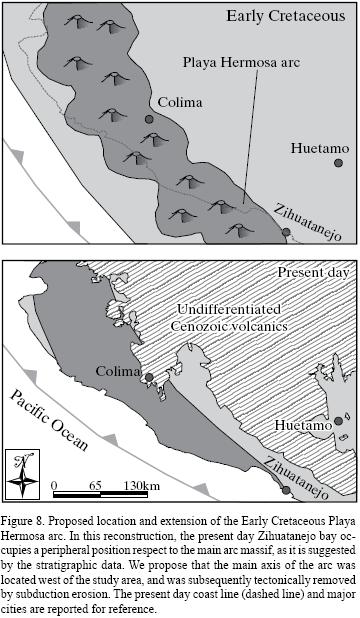
During the Early Cretaceous, the shallow marine rocks of the Playa Hermosa assemblage were deposited unconformably on top of the folded rocks of the Las Ollas Complex and Lagunillas Formation. The base of the Playa Hermosa assemblage is represented by the Posquelite Formation, which is composed of conglomerate and sandstone. Conglomerate is made up mostly of boulders and cobbles of metamorphic rocks similar to the lithotypes observed in the Las Ollas and Arteaga complexes. Moreover, sandstones of the Posquelite Formation plot in the same field of the Arteaga Complex and Lagunillas Formation in the QmFL composition diagram (Figure 5). On the basis of these considerations, we infer that the Posquelite Formation represents the product of the erosion of the pre–Cretaceous basement rocks. The Playa Hermosa Formation plots in the transitional arc field of the QmFL composition diagram (Figure 5) and marks the beginning of the volcanic activity in the Zihuatanejo area. Clasts of quartz, detrital muscovite, and metamorphic rocks decrease in abundance from the Posquelite to the Playa Hermosa formations, whereas plagioclase and fragments of lava increase significantly. This suggests that the pre–Cretaceous basement was widely blanketed by Early Cretaceous sediments during the deposition of the Playa Hermosa Formation, and that the main source of detritus was an arc massif. However, based on field evidence and our new isotopic ages, we have shown that the 1500 m–thick volcanic pile exposed in the study area does not belong to the Early Cretaceous marine volcano–sedimentary succession as previously inferred, but rather to a Middle Eocene overlapping unit. Ascribing these lavas to the Eocene drastically reduces the amount of Early Cretaceous volcanic rocks to only a few meters of andesite flows at the top of the Playa Hermosa Formation. This suggests that, during the Early Cretaceous, the Zihuatanejo basin was in a peripheral position with respect to the axis of the volcanic arc, which could have been located in a more westward position, and subsequently tectonically removed by subduction erosion (Figure 8). The Albian limestone of the Ixtapa Formation conformably overlies the Playa Hermosa Formation, pre–dating the beginning of the volcanic activity in the Zihuatanejo area.
During the Late Cretaceous, deposition occurred dominantly under continental conditions. The La Unión red beds were previously considered to be interbedded with the Albian Ixtapa limestone (Vidal–Serratos, 1986); however, we observed in the field that the continental rocks always overlie the Ixtapa Formation. Such stratigraphic relation is also supported by the ubiquitous presence of a conglomerate with boulders and cobbles of the Albian limestone at the base of the La Unión Formation, and by the ~88 Ma youngest detrital zircons from the basal beds of the continental succession (Martini and Ferrari, 2009; Martini and Ferrari, submitted). This age also indicate a stratigraphic hiatus of ~10 Ma between the deposition of the Albian Ixtapa Formation and the beginning of the continental sedimentation. In the vicinity of the Zihuatanejo bay, the continental rocks are lacking and the Ixtapa Formation is overlain directly by the shallow marine volcanic and sedimentary rocks of the Zihuatanejo Formation of early Late Cretaceous age (Talavera–Mendoza et al., 2007). The fact that the Zihuatanejo and La Unión formations occupy the same stratigraphic position, the lack of a clear stratigraphic contact between them, and the occurrence of comparable youngest detrital zircon populations in these units suggest that they are at least in part correlative (see Figure 2). Santonian–Maastrichtian red beds similar to the continental rocks of the La Unión Formation have been reported in the eastern Zihuatanejo terrane, in the vicinity of the city of Huetamo, ~80 km northeast of the study area, where they have been defined as Cutzamala Formation (Campa and Ramírez, 1979; Benammi et al., 2005; Centeno–García et al., 2008; Martini et al., 2009). In this region the continental rocks display only upright gently folds, and unconformably overlie folded Early Cretaceous–Cenomanian volcano–sedimentary marine successions of the Zihuatanejo and Arcelia terrane (Centeno–García et al., 2008; Martini et al., 2009). The continental rocks of the Cutzamala Formation are thus an overlap succession of the Guerrero terrane (Centeno–García et al. 2008), and postdate a regional folding event that has been related to the beginning of the Laramide shortening in this area (Martini et al., 2009). A similar scenario can be proposed for the study area. Five lines of evidence indicate that the Lower Cretaceous rocks of the Playa Hermosa assemblage were uplifted by folding, and subsequently eroded before the deposition of the La Unión Formation: 1) the abrupt change from the Early Cretaceous shallow marine to the Late Cretaceous dominantly continental rocks; 2) the unconformable contact between the Ixtapa and the La Unión formations; 3) the stratigraphic hiatus of ~10 Ma between the deposition of the Albian Ixtapa Formation and the beginning of the continental sedimentation; 4) the occurrence of clasts of the Ixtapa Formation in the basal conglomerate of the La Unión Formation; 5) the occurrence of decimetric to kilometric upright open folds in the Early Cretaceous shallow marine rocks, in contrast to the kilometric upright gentle folds observed in the La Unión Formation. Based on these considerations, we propose that the La Unión and Zihuatanejo Formation should not be included within the Guerrero terrane, but rather constitute overlap successions post–dating the possible accretion of this terrane to nuclear Mexico.
CONCLUSIONS
We propose a redefinition of the stratigraphy of the Zihuatanejo area based on new geologic mapping, pe–trographic study, and U–Pb and 40Ar/39Ar geochronology. From the base to the top of the structural and stratigraphic succession, we recognize:
1) a polydeformed and partly metamorphosed pre–Cretaceous basement, composed of the Las Ollas Complex and Lagunillas Formation;
2) the Lower Cretaceous shallow marine Playa Hermosa arc assemblage, which conformably overlies the Las Ollas Complex and the Lagunillas Formation;
3) the Upper Cretaceous continental to shallow marine La Unión–Zihuatanejo arc assemblage, which unconform–ably overlies the Early Cretaceous volcanic and sedimentary rocks;
4) the Eocene El Camalote arc assemblage, composed of an intrusive suite and the coeval El Camalote volcano–sedimentary Formation, which unconformably overlie all the Mesozoic rocks of the Zihuatanejo region.
Based on the regional correlation with the Upper Cretaceous continental succession exposed in the nearby Huetamo area, we propose that the La Unión–Zihuatanejo assemblage should not be considered part of the Guerrero terrane but rather as an overlap assemblage post–dating the possible accretion of this terrane to nuclear Mexico.
ACKNOWLEDGEMENTS
The research was funded by CONACyT (Consejo Nacional de Ciencia y Tecnología) grant SEP 2003–C02–42642 to Ferrari. Victor Pérez, Susana Rosas, and Miguel Angel García helped with the mineral separations, 40Ar–39Ar mass spectrometry measurements, and data processing at the CICESE Geochronologic laboratory. Juan Tomás Vasquez prepared thin sections. Ofelia Pérez Arvizu performed trace elements analysis. NSF–EAR 0443387 and 0732436 for support of the Arizona LaserChron Center. Reviews by W.R. Dickinson, R.S. Molina, and T.F. Lawton substantially improved the manuscript.
APPENDIX A. SUPPLEMENTARY DATA
Tables A1, A2 and A3 can be found at the journal web site <http://satori.geociencias.unam.mx/>, in the table of contents of this issue (electronic supplement 273–01).
REFERENCES
Benammi, M., Centeno–García, E., Martínez–Hernández, E., Morales–Gámez, M., Tolson, G., Urrutia–Fucugauchi, J., 2005, Presencia de dinosaurios en la Barranca Los Bonetes en el sur de México (Región de Tiquicheo, Estado de Michoacán) y sus implicaciones cronoestratigráficas: Revista Mexicana de Ciencias Geológicas, 22 (3), 429–435. [ Links ]
Cabral–Cano, E., Draper, G., Lang, H.R., Harrison, C.G.A., 2000, Constraining the Late Mesozoic and Early Tertiary tectonic evolution of southern Mexico: structure and deformation history of the Tierra Caliente region: The Journal of Geology, 108, 427–446. [ Links ]
Campa, M.F., Coney P. J., 1983, Tectono–stratigraphic terranes and mineral resource distribution in Mexico: Canadian Journal of Earth Sciences, 20, 1040–1051. [ Links ]
Campa, M.F., Ramírez, J., 1979, La evolución geológica y la metalogénesis del noroccidente de Guerrero: Universidad Autónoma de Guerrero, serie Técnico–Científica, 1, 101 pp. [ Links ]
Centeno–García, E., Ruiz, J., Coney, P.J., Patchett, P.J., Ortega–Gutiérrez, F., 1993, Guerrero terrane of Mexico: its role in the Southern Cordillera from new geochemical data: Geology, 21, 419–422. [ Links ]
Centeno–García, E., Corona–Chávez, P., Talavera–Mendoza, O., Iriondo, A., 2003, Geologic and tectonic evolution of the western Guerrero terrane – a transect from Puerto Vallarta to Zihuatanejo, Mexico, in Alcayde, M., Gómez–Caballero, A. (eds.), Geologic transects across Cordilleran Mexico, Guidebook for the field trips of the 99th Geological Society of America Cordilleran Section Annual Meeting, Puerto Vallarta, Jalisco, Mexico, April 4–7, 2003, Universidad Nacional Autónoma de México, Instituto de Geología, Special Paper 1, 201–228. [ Links ]
Centeno–García, E., Guerrero–Suastegui, M., Talvera–Mendonza, O., 2008, The Guerrero Composite Terrane of western Mexico: collision and subsequent rifting in a suprasubduction zone: Geological Society of America, Special Paper 436, 279–308. [ Links ]
Dickinson, W.R., 1970, Interpreting detrital modes of graywacke and arkose: Journal of Sedimentary Petrology, 40, 695–707. [ Links ]
Dickinson, W.R., 1985, Interpreting provenance relations from detrital modes of sandstones, in Zuffa, G.G. (ed.), Provenance of arenites: NATO Advanced Study Institute Series 148: Dordrecht, Netherlands, D. Reidel, p. 3–61. [ Links ]
Dickinson, W.R., Lawton, T.F., 2001, Carboniferous to Cretaceous assembly and fragmentation of Mexico: Geological Society of America Bulletin, 113, 1142–1160. [ Links ]
Elías–Herrera, M., Sánchez–Zavala, J.L., Macías–Romo, C., 2000, Geologic and geochronologic data from the Guerrero terrane in the Tejupilco area, southern Mexico: New constraints on its tectonic interpretation: Journal of South American Science, 13, 355–375. [ Links ]
Folk, R.L., 1974, Petrology of sedimentary rocks: Austin, Texas, Hemphill Publishing Company, 182 p. [ Links ]
Gehrels, G.E., Valencia, V.A., Ruiz, J., 2008, Enhanced precision, accuracy, efficiency, and spatial resolution of U–Pb ages by laser ablation–multicollector–inductively coupled plasma–mass spectrometry: Geochemistry, Geophysics, Geosystems, 9 (3), Q03017, doi:10.1029/2007GC001805. [ Links ]
Guerrero–Suástegui, M., 1997, Depositional History and Sedimentary Petrology of the Huetamo Sequence, southwestern Mexico, El Paso, University of Texas, Master Thesis, 95 p. [ Links ]
Harrison, T.M., McDougall, I., 1981, Excess 40Ar in metamorphic rocks from Broken Hill, New South Wales: implications for 40Ar/39Ar age spectra and thermal history of the region: Earth and Planetary Science Letters, 55, 123–149. [ Links ]
Kaneoka, I., 1974, Investigation of excess argon in ultramafic rocks from the Kola Peninsula by the 40Ar/39Ar method: Earth and Planetary Science Letters, 22, 145–156. [ Links ]
Keppie, D.J., 2004, Terranes of Mexico revisited: a 1.3 billion year odyssey: International Geology Review, 46, 765–794. [ Links ]
Lang H.R., Barros J.A., Cabral–Cano E., Draper G., Harrison C.G.A., Jansma P.E., Johnson C.A., 1996, Terrane deletion in northern Guerrero state: Geofísica Internacional, 35 (4), 349–359. [ Links ]
Lanphere, M.A., Dalrymple, G.B., 1976, Identification of excess 40Ar by the 40Ar/39Ar age spectrum tecnique: Earth and Planetary Science Letters, 32, 141–148. [ Links ]
Le Bas, M.J., Le Maitre, R.W., Streckeisen, A., Zanettin, B., 1986, A chemical classification of volcanic rocks based on the total alkali silica diagram: Journal of Petrology, 27, 745–750. [ Links ]
Lozano–Santa Cruz, R., Verma, S.P., Girón, P., Velasco–Tapia F., Morán–Zenteno, D., Viera, F., Chávez, G., 1995, Calibración preliminar de Fluorescencia de rayos X para análisis cuantitativo de elementos mayores en rocas ígneas: Actas INAGEQ, 1, 203–208. [ Links ]
Martini, M., Ferrari, L., 2009, Kinematics and chronology of the Laramide shortening in the Huetamo–Zihuatanejo area (southern Mexico): was it really related to the accretion of the Guerrero terrane?, Geological Society of America, Cordilleran Section Meeting, 7–9 May 2009, Kelowna, British Columbia, Canada, Abstracts with Programs. [ Links ]
Martini, M., Ferrari, L., submitted, Kinematics and geochronology of the Late Cretaceous shortening deformation in the Zihuatanejo area (south–western Mexico): implications for the timing and style of the Mexican Laramide orogeny: Geological Society of America Special Paper. [ Links ]
Martini, M., Ferrari, L., López–Martínez, M., Cerca–Martínez, M., Valencia, V., Serrano–Duran, L., 2009, Cretaceous–Eocene magmatism and Laramide deformation in Southwestern Mexico: no role for terrane accretion, in Kay, S.M., Ramos, V.A., Dickinson, W.R. (eds.), Backbone of the Americas: Shallow Subduction, Plateau Uplift, and Ridge and Terrane Collision: Geological Society of America Memoir 204, 151–182. [ Links ]
McCulloch, M.T., Gamble, J.A., 1991. Geochemical and geodynamical constraints on subduction zone magmatism: Earth and Planetary Science Letters, 102, 358–374. [ Links ]
McDonough, W.F., Sun, S.S., 1995, The composition of the Earth: Chemical Geology, 120, 223–253. [ Links ]
Milkov, A.V., 2000, Worldwide distribution of submarine mud volcanoes and associated gas hydrates, Marine Geology, 167, 29–42. [ Links ]
Mori, L., Gómez–Tuena, A., Cai, Y., Goldstein, S.L., 2007, Effects of prolonged flat subduction on the Miocene magmatic record of the central Trans–Mexican Volcanic Belt: Chemical Geology, 244, 452–473. [ Links ]
Pantoja–Alor, J., Gómez–Caballero, J.A., 2003, Geologic features and biostratigraphy of the Cretaceous of southwestern México (Guerrero Terrane), in Alcayde, M., Gómez–Caballero, A. (eds.), Geologic transects across Cordilleran Mexico, Guidebook for the field trips of the 99th Geological Society of America Cordilleran Section Annual Meeting, Puerto Vallarta, Jalisco, Mexico, April 4–7, 2003, Universidad Nacional Autónoma de México, Instituto de Geología, Special Paper 1, 229–260. [ Links ]
Salinas–Prieto, J.C., Monod, O., Faure, M., 2000, Ductile deformations of opposite vergence in the eastern parto f the Guerrero Terrane (SW Mexico): Journal of South American Earth Science, 13, 389–402. [ Links ]
Stacey, J.S., Kramers, J.D., 1975, Approximation of terrestrial lead isotope evolution by a two–stage model: Earth and Planetary Science Letters, 26, 207. [ Links ]
Steiger, R.H., Jäger, E., 1977, Subcommission on Geochronology: Convention on the use of decay constants in Geo and Cosmochronology: Earth and Planetary Science Letters, 36, 359–362. [ Links ]
Sun, S.S., McDonough, W.F., 1989, Chemical and isotopic systematics of oceanic basalts: implications for mantle composition and processes, in Saunders, A.D., Norry, M.J. (eds.) Magmatism in the ocean basins: Geological Society Special Publications, 42, 313–346. [ Links ]
Talavera–Mendoza, O., 2000, Mélange in southern Mexico: Geochemistry and metamorphism of the Las Ollas Complex (Guerrero Terrane): Canadian Journal of Earth Science, 13 (4), 337–354. [ Links ]
Talavera–Mendoza, O., Guerrero–Suástegui, M., 2000, Geochemistry and isotopic composition of the Guerrero Terrane (western Mexico): Implication for the tectono magmatic evolution of southwestern North America during the Late Mesozoic: Journal of South American Earth Science, 13, 297–324. [ Links ]
Talavera–Mendoza, O., Ruiz, J., Gehrels, G.E., Valencia, V.A., Centeno–García, E., 2007, Detrital zircon U/Pb geochronology of southern Guerrero and western Mixteca arc successions (southern Mexico): New insights for the tectonic evolution of the southwestern North America during the late Mesozoic: Geological Society of America Bulletin, 119, 1052–1065. [ Links ]
Tardy, M., Lapierre, H., Freydier, C., Coulon, C., Gill, J.B., Mercier De Lepinay, B., Beck, C., Martínez, J., Talavera–Mendoza, O., Ortiz, E., Stein, G., Bourdier, J.L., Yta, M., 1994, The Guerrero suspect terrane (western Mexico) and coeval arc terranes (the Greater Antilles and the Western Cordillera of Colombia): a late Mesozoic intra–oceanic arc accreted to cratonal America during the Cretaceous: Tectonophysiscs, 230, 49–73. [ Links ]
Valencia, V.A., Ducea, M., Talavera–Mendoza, O., Gehrels, G., Ruiz, J., Shoemaker, S., 2009, U–Pb geochronology of granitoids in the north–western boundary of the Xolapa terrane: Revista Mexicana de Ciencias Geológicas, 26 (1), 189–200. [ Links ]
Verma, S.P., Lozano–Santa Cruz, R., Girón, P., Velasco–Tapia, F., 1996, Calibración preliminar de Fluorescencia de rayos X para análisis cuantitativo de elementos traza en rocas ígneas: Actas INAGEQ, 2, 237–242. [ Links ]
Vidal–Serratos, R., 1986, Tectónica de la región de Zihuatanejo, Guerrero, Sierra Madre del Sur, Ciudad de México, México, Instituto Politécnico Nacional, Bachelor Thesis, 155 p. [ Links ]
Vidal–Serratos, R., 1991, El miembro Posquelite de la Formación Zihuatanejo, evidencia estratigráfica de un sustrato continental para el arco Albiano de Zihuatanejo, Estado de Guerrero: Convención sobre la evolución geológica de México, Primer Congreso Mexicano de Mineralogía, Pachuca, Memoirs, 228–229. [ Links ]
Walker, J. D., Geissman, J. W., 2009, Commentary: 2009 Geologic Time Scale: GSA Today, 19, 60–61. [ Links ]
Wilson, M., 1989, Igneous petrogenesis, a global tectonic approach: London, Unwin Hyman, 466 pp. [ Links ]
York, D., Evensen, N.M., López–Martínez, M., De Basabe–Delgado, J., 2004, Unified equations for the slope, intercept, and standard errors of the best straight line: American Journal of Physics, 73 (3), 367–375. [ Links ]

