


Services on Demand
Journal

Article
 English (pdf)
 Article in xml format
 Article references
 Send this article by e-mail
Indicators
 Cited by SciELO
 Related links
-
 Similars in
SciELO
Similars in
SciELO
Share

 Permalink
Revista mexicana de ciencias geológicas
On-line version ISSN 2007-2902Print version ISSN 1026-8774
Rev. mex. cienc. geol vol.27 n.2 Ciudad de México Aug. 2010
Arizpe sub–basin: A sedimentary and volcanic record of Basin and Range extension in north–central Sonora, Mexico
La subcuenca de Arizpe: Registro sedimentario y volcánico de la extensión de Sierras y Cuencas en el centro–norte de Sonora, México
Carlos M. González–León1*, Víctor A. Valencia2, Margarita López–Martínez3, Hervé Bellon4, Martín Valencia–Moreno1, and Thierry Calmus1
1 Estación Regional del Noroeste, Instituto de Geología, Universidad Nacional Autónoma de México, Apartado Postal 1039, 83000 Hermosillo, Sonora, México. * cmgleon@unam.mx
2 Geosciences Department, University of Arizona, Tucson, Arizona 85721, USA.
3 Departamento de Geología, Centro de Investigación Científica y de Educación Superior de Ensenada (CICESE), Km 107 Carretera Ensenada–Tijuana No. 3918, 22860 Ensenada, Baja California, México.
4 UMR 6538, Domaines Océaniques, IUEM, Université de Bretagne Occidentale, 6, Av. Le Gorgeu, Brest, 29285, France.
Manuscript received: July 31, 2009.
Corrected manuscript received: May 16, 2010.
Manuscript accepted: May 19, 2010.
ABSTRACT
The Arizpe sub–basin located in the northern part of the Río Sonora basin is a Basin and Range half–graben that initiated during Late Oligocene time in north–central Sonora. Its ~2.1 km–thick, east–dipping volcanic and sedimentary fill assigned to the Báucarit Formation is divided, from base upwards, into the following informal members. The La Cieneguita member composed ofinterbedded conglomerate, siltstone and gypsum beds which unconformably overlay older Cenozoic volcanic rocks; the El Toro Muerto basalt composed of basaltflows, basalt breccia and subordinate conglomerate beds; the Arzipe conglomerate composed of three fining–upwards conglomerate sequences that interdigitates with flows of the Tierras Prietas basalt in its lower part and the Agua Caliente basalt in its upper part; the Bamori member is a coarsening–upward succession of siltstone, sandstone and conglomerate that unconformably overlies the Arizpe conglomerate and it is unconformably overlain by the sedimentary El Catalán breccia. Basin accommodation started at ~25 Ma when deposition of the La Cieneguita member, followed by alkaline basaltic volcanism of the El Toro Muerto and contemporaneous rhyolitic volcanism, floored the area predating significant clastic deposition. The Agua Caliente basalt (~21 Ma) in the upper part of the basin fill indicates the basin was rapidly subsiding.
Multiple phases of normal faulting affected the Arizpe sub–basin. The main controlling structure may be the steep (80°), west–dipping, sub–parallel El Fuste and Granaditas normal faults that bound the Arizpe sub–basin at its present–day eastern margin, or there may be afault orfaults that were subsequently buried beneath younger basin fill near the eastern margin of the basin. The basin was disorganized by an even younger NW–SE phase of normal faulting represented by the southwest–dipping Crisanto and Tahuichopa faults. Growth strata within basin fill suggests that syntectonic deposition was active during all phases of normal faulting. However, punctuated tectonic activity on these faults may have controlled deposition of conglomerate sequences of the Arizpe conglomerate.
Geochemical data from the El Toro Muerto, the Tierras Prietas and the Agua Caliente basalt members indicate they are high–K, alkaline to subalkaline basaltic trachyandesites with light REE–enriched patterns, initial Sr ratios between 0.7069 and 0.7076, and εNd values between –3.76 and –4.88. Pb isotopic values from two samples of the El Toro Muerto basalt yielded very similar results, and along with the other geochemical data suggest an important participation of the continental lithosphere as magma source for this volcanism.
The data herein reported are supported by eight new geochronologic ages and they contribute to better document and constrain the timing of magmatism and extension in the Basin and Range tectonic province in Sonora.
Key words: magmatism, geochronology, Oligocene, Miocene, Basin and Range, Sonora, Mexico.
RESUMEN
La subcuenca de Arizpe, localizada en la parte norte de la cuenca del Río Sonora, es un medio graben que empezó a formarse durante el Oligoceno Tardío asociado a la deformación de Sierras y Valles Paralelos (Basin and Range). Su relleno volcánico y sedimentario de ~2.1 km de espesor, el cual buza hacia el oriente, se asigna a la Formación Báucarit y se divide, de la base a la cima, en los siguientes miembros informales. El miembro La Cieneguita, formado por conglomerado con intercalaciones de limolita y yeso, que sobreyace discordantemente a rocas volcánicas cenozoicas más antiguas; el basalto El Toro Muerto, formado por derrames de basalto, brecha basáltica y en menor proporción por conglomerado. El conglomerado Arizpe, formado por tres secuencias conglomeráticas grano decreciente hacia su cima y con interdigitaciones del basalto Tierras Prietas en su parte inferior y del basalto Agua Caliente en su parte superior. El miembro Bamori, formado por limolita, arenisca y conglomerado en secuencia grano–creciente hacia su cima, sobreyace en discordancia al conglomerado Arizpe y está a su vez sobreyacido discordantemente por la brecha El Catalán formada por clastos de basalto. La subcuenca Arizpe empezó a formarse hace ~25 Ma cuando la sedimentación terrígena del miembro La Cieneguita y el volcanismo alcalino del basalto El Toro Muerto precedieron a la sedimentación clástica del conglomerado Arizpe. La edad de ~21 Ma obtenida del basalto Agua Caliente, que ocurre en la parte superior del relleno de la cuenca, indica que ésta fue una cuenca de subsidencia rápida.
El fallamiento normal que inició a la cuenca tuvo lugar cerca de su actual margen oriental y controló el depósito de las secuencias conglomeráticas. En esa posición se ubican las fallas normales El Fuste y Granaditas que buzan al poniente, pero es probable que la falla principal se encuentre actualmente cubierta debajo de rocas más jóvenes del relleno de la cuenca. El fallamiento sinsedimentario fue importante y, después de su formación, la sub–cuenca Arizpe fue desorganizada por fallamiento normal de rumbo NW–SE representado por las fallas Crisanto y Tahuichopa.
Datos geoquímicos de los basaltos El Toro Muerto, Tierras Prietas y Agua Caliente indican que corresponden a traquiandesitas basálticas ricas en K, que varían de alcalinas a subalcalinas con un patrón de enriquecimiento en tierras raras ligeras, con relaciones isotópicas de Sr inicial entre 0.7069y 0.7076y valores iniciales de εNd entre –3.76 y –4.88. Análisis isotópicos de Pb en dos muestras del basalto El Toro Muerto arrojan valores muy parecidos y, en conjunto, estos datos sugieren una participación importante de la litósfera continental como fuente de los magmas de este volcanismo.
Los datos reportados se apoyan además en ocho nuevos fechamientos y contribuyen a documentar el tiempo del magmatismo y la extensión de la provincia tectónica de la Basin and Range en Sonora.
Palabras clave: magmatismo, tectónica, geocronología, Oligoceno, Mioceno, Basin and Range, Sonora, México.
INTRODUCTION
Although most of the state of Sonora is located within the late Cenozoic southern Basin and Range extensional province and the sedimentary and volcanic fill of numerous NNW–SSE–oriented basins that formed during this tectonic event are well exposed, only a few studies have been conducted to understand their sedimentary, magmatic and tectonic history. King (1939) first noted that the fills of these valleys in southern Sonora are mostly composed of a lower basaltic member and an upper conglomerate member that he named as the Báucarit Formation in outcrops at the town of Báucarit (Figure 1).
Other workers suggested that not all of the late Cenozoic extensional basins in Sonora share similar sedimentary and magmatic histories (Gans, 1997; McDowell et al, 1997) and applied different informal names to their fill deposits. The first attempts to understand the sedimentary history of some of these basins were conducted by Miranda– Gasca and DeJong (1992) and De la O–Villanueva (1993), who studied the Magdalena and the Río Yaqui basins (Figure 1), respectively. Other authors studied the Ures basin in central Sonora (Calles–Montijo, 1999; Vega–Granillo and Calmus, 2003). McDowell et al. (1997) and Gans (1997), however, studied in more detail the magmatism and tectonic development of the late Cenozoic basins in the Río Yaqui region and nearby areas of south central Sonora. Their results indicate that the fills of the Basin and Range basins are dominated by mafic flows in their lower parts and by conglomerate in their upper parts, and in most cases the name Báucarit Formation was applied to describe that succession.
The Río Sonora basin is an informal name that we apply to one of these N–S–elongated Basin and Range grabens located in the north–central part of Sonora, between the towns of Arizpe and Mazocahui (Figure 1). This basin is 100 km–long and 15 to 25 km–wide. Our results indicate that the Río Sonora basin is a tectonically and sedimentologically complex half–graben that is limited to the east and west by elevated mountains ranges composed of sedimentary, volcanic and plutonic rocks, which range in age from Proterozoic to Miocene. At its northern and southern boundaries, the Río Sonora basin is in fault contact with high mountainous ranges.
In this work, we present results for the northernmost part of the Río Sonora basin located near the town of Arizpe, which we name the Arizpe sub–basin. The well–exposed sedimentary and volcanic fill of this sub–basin allows for its stratigraphic and structural relationships to be easily studied. Our aim is to contribute to the understanding of the sedimentary and magmatic history of a typical, complexly–deformed graben located within the Basin and Range province of Sonora based on geologic mapping, detailed measurement of the entire basin stratigraphic section, and on geochronology, geochemical and radiogenic isotopic analyses of some of the interbedded volcanic flows.
GEOLOGIC SETTING
The Arizpe sub–basin is a N–S– striking half–graben filled by a Late Oligocene–Early Miocene, eastward thickening succession of interbedded mafic flows, subordinate ash–fall tuffs and ignimbrite, and clastic rocks that González–León et al. (2000) first assigned to the Arizpe conglomerate. The basin was developed over a basement composed of strata assigned to the Lower Cretaceous Bisbee Group and to Upper Cretaceous – Cenozoic volcanic rocks of the Tarahumara Formation (González–León et al, 2000) (Figure 2). A rhyolitic unit with minor basalt flows that crops out in the eastern part of the area might be correlative with the Cerro Cebadehuachi volcanic rocks, a unit of Oligocene age that was reported from its outcrops about 10 km north of the study area (González–León et al, 2000). Based on our more detailed stratigraphic study, we divide the basin–fill succession into seven members, restrict the term Arizpe conglomerate to one of them and reassign the whole succession to the Báucarit Formation.
From base upwards, the Báucarit Formation is composed of the following informal members: La Cieneguita member, El Toro Muerto basalt, the Arizpe conglomerate that laterally interfingers with the Tierras Prietas and Agua Caliente basalt members, the Bamori member and the El Catalán breccia (Figures 2 and 3).
The Báucarit Formation is exposed in the Arizpe valley but in this study the continuous stratigraphic thickness of the La Cieneguita member, El Toro Muerto basalt and the Arizpe conglomerate were measured with a Jacob's staff along the El Toro Muerto creek, between rancho La Cieneguita to the west and the town of Bamori to the east (Figure 2). The uppermost part of the Arizpe conglomerate was measured along Interstate road 89 from the Arroyo Agua Caliente to the town of Tahuichopa (Figure 2). Along the El Toro Muerto section the Arizpe conglomerate interdigitates in its lower part with the Tierras Prietas basalt, and in its upper part with the Agua Caliente basalt members (Figure 3). The thickness of the Tierras Prietas and Agua Caliente basalts were estimated from their more complete outcrops along the arroyo Tetuachi creek located about 6 km south of the El Toro Muerto Creek and along the gorge cut by the Río Sonora just south of the town of Bamori, respectively (Figure 2). The thickness of the Bamori member was measured in outcrops located just east of the town of Bamori, and the thickness of the Catalán breccias was estimated from outcrops along the Cañada Catalán located southeast of the town of Bamori. A 1:50,000–scale geologic mapping of the study area was refined from previous works by González–León et al. (2000) and González–Gallegos et al. (2003). To constrain the age of the Báucarit Formation we report four new Ar–Ar ages, three K–Ar ages and one U–Pb zircon age of mafic and rhyolite rocks. These data are complemented with two Ar–Ar ages reported by González–León et al. (2000) from the study area, as discussed below. Additionally, we include seven new geochemical analyses and three Sr–Nd–Pb isotopic analyses of volcanic rocks which are complemented with previous geochemical data reported in González–León et al. (2000).
STRATIGRAPHY
The La Cieneguita member (Figures 2 and 3) consists in its lower part of a 60 m–thick package of pebble conglomerate and coarse–grained sandstone that stratigraphically grades upwards into a 50 m–thick interval of reddish brown mudstone–siltstone, with interbedded gypsum (beds < 5 cm thick) and granule to fine–grained sandstone (thin to medium beds). This member unconformably rests on altered volcanic rocks assigned to the Tarahumara Formation or on rhyolitic tuffs of probable Oligocene age (not differentiated in Figure 2). The La Cieneguita member is not always present at the base of the Arizpe Conglomerate, probably because it was partly eroded after deposition or because it was deposited on an uneven erosional surface, and where this occurs, the El Toro Muerto basalt unconformably rests on the older rocks.
The El Toro Muerto basalt sharply overlies the La Cieneguita member, and consists of basalt flows, basalt breccia and subordinate conglomerate beds (Figures 2 and 3). The basalt flows are fine–grained and petrographically classify as porphyritic olivine basalt with phenocrysts of plagioclase and scarce augite pyroxene in a pseudotraquitic matrix of microlitic andesine (An 34–50). A local, 100 m–thick outcrop of a rhyolitic welded tuff exposed through a fault contact in the central part of the area and that we informally name the Tetuachi ignimbrite, is a probable interdigitation of the Tierras Prietas basalt, according to its geochronologic age (Figure 3). The El Toro Muerto basalt is in turn stratigraphically overlain by the Arizpe conglomerate, but toward the southwestern part of the study area these members are interbedded (Figure 2). The estimated thickness of this member is 200 m.
The stratigraphic column of the Arizpe conglomerate is 1,600 m–thick along the measured section of the El Toro Muerto creek. The lowermost part of the El Toro Muerto conglomerate consists of a 20 m–thick interval of massive, green to light gray siltstone, whereas the remainder upper part of the succession is predominantly conglomerate that forms three fining–upward sequences distinguished on the basis of their maximum clast sizes. These sequences are described below as the lower, middle and upper conglomerate sequences (Figure 3).
The lower conglomerate sequence is 340 m thick (Figure 3) and in its lower part consists of poorly–sorted, pebble to cobble conglomerate with clasts (mostly <10 cm long) of basalt (~60%), andesite (~20%), rhyolite (~15%) and scarce diorite (Figure 4a). The largest clasts are scattered cobbles of basalt up to 80 cm–long. A few beds of white, lithic– and crystal–rich ash–fall tuffs up to 3 m thick (Figure 4b) are interbedded within this part of the section, along with a 50 m–thick flow of the Tierras Prietas basalt. The middle and upper parts of this lower sequence mostly consists of poorly sorted, subangular to subrounded pebble–conglomerate in beds up to 3 m thick, but they more commonly occur in beds less than 60 cm thick, because of abundant reactivation surfaces. The conglomerate beds are mostly clast–supported and commonly have interbeds of thin, lenticular, coarse–grained to granule sandstone, which occasionally show fining–upward cycles. Planar cross–stratification and large–scale trough cross–stratification are locally present. In the upper part of this sequence, the largest clasts are of basalt and decrease in size to 20 cm.
The middle conglomerate sequence is 590 m thick and also has interdigitations of the Tierras Prietas basalt. Conglomerate beds in this cycle are up to 3 m thick but abundant reactivation surfaces (multistory) obliterate the original thicknesses of the fining–upward cycles. These beds are mostly pebble and rarely cobble, poorly sorted, subangular conglomerate with local, poorly–developed planar and trough cross–stratification. The largest clasts in this sequence are scattered fragments of basalt that reach up to 40 cm long in the lower part and are up to 6 cm long in its upper part. Near its upper part, the sequence has intervals up to 30 m thick of well stratified and well consolidated fine– to coarse–grained sandstone with interbedded yellow to reddish, bioturbated siltstone and white ash–fall tuffs beds (Figure 4c). The sequence ends with a 110 m thick pebble conglomerate (clasts <5 cm long) with interbeds of thin– to medium–bedded, lenticular, fine– to coarse–grained sandstone. Clast compositions in this sequence are of andesite (~50%), basalt (~35%) and rhyolite (~15%).
The upper conglomerate sequence is 650 m thick and consists of medium to thick, poorly defined beds of pebble conglomerate, sandy pebble conglomerate, pebble sandstone and more rarely cobble conglomerate in beds up to 4 m thick, with lenticular beds of coarse– to medium–grained sandstone. Beds composing fining–upward sequences can be present, but their upper parts are generally cut by abundant reactivation surfaces. The conglomerate is mostly clast–supported, but matrix–supported conglomerate also occur. Clasts are poorly sorted, subrounded to subangular, and consist of andesite (~50%), rhyolite (~40%) and basalt (~10%). Planar and trough cross stratification in bedsets up to 40 cm thick and crude horizontal stratification of clasts occasionally occurs. The largest clasts in the lower part of this sequence are of basalt and reach up to 35 cm in length. The uppermost 150 m of this sequence consists of poorly sorted, clast–supported, subrounded pebble conglomerate, with a rich matrix of pebble to granule sandstone that interbeds with fine– to coarse–grained, lenticular sandstone. These lithologies grade to the top of the sequence to well–stratified granule and coarse–grained sandstone. Reactivation surfaces are abundant in the upper part of the sequence, whereas sandstone beds up to 50 cm thick are more laterally continuous. Maximum clast sizes in this part of the sequence reaches 10 cm in length and consist of andesite (~50%), rhyolite (~30%), dacite (~10%) and basalt (~10%). At its middle and upper parts this sequence has interdigitations of the Agua Caliente basalt.
The Tierras Prietas basalt has a thickness of about 700 m estimated from outcrops along the Tetuachi creek, located south of the El Toro Muerto creek (Figure 2). This member consists of superimposed 50 to 100 m–thick, fine–grained flows of basalt and basaltic breccias, which in their upper parts develop reddish, altered intervals up to 20 m thick of probably pedogenic origin (Figure 4d). Petrographically, this rock is a porphyritic olivine basalt with phenocrysts of plagioclase (An38–50) and subordinate clinpyroxene (augite?), sorted in a rich pseudotraquitic matrix of microlitic plagioclase. Along the El Toro Muerto measured section, flows of the Tierras Prietas basalt laterally interdigitate with the lower and middle conglomerate sequences of the Arizpe conglomerate (Figure 3).
The Agua Caliente basalt has an estimated thickness of 300 m in outcrops along the Río Sonora gorge, just south of the town of Bamori (Figure 2). The Agua Caliente basalt consists of poorly stratified, fine–grained mafic flows and breccia. The basalt flows display abundant calcite–filled cavities and petrographically show an abundant pseudotraquitic matrix of microlitic plagioclase with scarce phenocrysts of plagioclase (An39–53), olivine and clynopyroxene.
The Bamori member is a 60 m–thick clastic interval that unconformably overlies the upper conglomerate sequence in outcrop exposed east of the Río Sonora (Figure 4e). It forms a thin, E–NE strip outcrop with shallow dips to the east. It is a coarsening–upward succession of massive, bioturbated siltstone and fine grained sandstone in its lower part, and massive, fine–grained sandstone with intercalations of medium–bedded, coarse–grained sandstone in cosets up to 5 m thick that show fining–upward successions in its middle part. The uppermost 20 m of this member consists of granule sandstone and lenticular, medium–bedded pebble conglomerate that are the lags of large–scale, epsilon cross–stratification.
The El Catalán breccia has an estimated thickness of 150 m and crops out in the eastern margin of the Arizpe basin. It is a coarse, crudely stratified breccia with clasts up to 2 m long (Figure 4f). The clasts are angular and poorly sorted, and most beds are matrix–supported. The matrix is a mixture of coarse sand and granules with occasional thin to medium, lenticular beds of granule conglomerate. The clasts are mostly derived from basalt (90%), but there are also clasts of andesite and rhyolite. This member shallowly dips to the west and unconformably overlies the Bamori member which dips to the east.
GEOCHRONOLOGY
A sample from the lowermost part of the El Toro Muerto basalt yielded a K–Ar age at 24.89 ± 0.64 Ma (sample 6–3–05–1; Tables 1 and 2, Figure 2), similar (within error) to an Ar–Ar (plateau age), sanidine age of 24.2 ± 0.4 Ma obtained from the Tetuachi ignimbrite (sample 10–10–06–1; Figure 5, Tables 1 and 3, Appendix). We also dated two basaltic samples from outcrops in the southeastern part of the area, which yielded similar Ar–Ar (plateau) ages at 23.3 ± 0.3 and 23.5 ± 0.2 Ma (samples 10–9–06–1 and 2–15–07–1; Figure 5; Tables 1 and 3). These basalt flows underlie, and are in fault contact with the El Catalán breccia and the Agua Caliente basalt (Figure 2) and we interpret them to belong to the upper part of the El Toro Muerto basalt on the basis of a similar age of 23.52 ± 0.17 Ma (Ar–Ar, sample A–101, Table 1, Figure 3) previously reported by González–León et al. (2000) from outcrops of that unit in the central part of the study area. González–León et al. (2000) also reported a 21.70 ± 0.20 Ma Ar–Ar age for a basalt flow from the middle part of the Tierras Prietas basalt (sample A–102D, Table 1, Figure 3). In this study, we obtained two K–Ar ages from two samples of the Agua Caliente basalt. The stratigraphi–cally lowermost of these samples yielded an age of 21.29 ± 0.55 Ma age (samples 6–3–05–3, Tables 1 and 2), while the stratigraphically uppermost one yielded an age of 21.51± 0.6 (sample 6–3–05–2, Tables 1 and 2) (Figure 3).
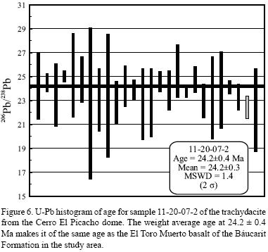
Furthermore, we herein report a U–Pb zircon age of 23.3 ± 0.6 Ma (sample 11–20–07–2, Tables 1 and 4, Figure 6) obtained from a sample of a rhyolite dome exposed at Cerro El Picacho, located at 11 km east of the town of Sinoquipe (Figure 2), which is contemporaneous with the El Toro Muerto basalt and could represent the source for the Tetuachi ignimbrite. Also, we report a 18.6 ± 0.2 Ma Ar–Ar, plateau age (sample 9–23–08–5, Tables 1 and 3, Figure 5) for a mafic flow informally named the El Pajarito basalt, which is interbedded in the upper part of the conglomeratic basin fill of the El Rodeo basin located east of the Arizpe sub–basin (Figure 1); these data help to constrain younger age of Basin and Range development in this region.
GEOCHEMISTRY AND ISOTOPIC RESULTS
In an effort to characterize the origin and nature of the source of the magmas of the study area, three samples from the El Toro Muerto basalt and one sample from the Agua Caliente basalt were analyzed for major and trace elements and Sr–Nd–Pb isotopic compositions (Tables 5 and 6; analytical procedures are described in the Appendix). We also analyzed major and trace elements from one sample of the Cerro El Picacho dome, one sample from the El Pajarito basalt and another one from the El Huarache basalt (Table 5); this last mafic flows comes from the basal part of the El Rodeo basin fill and we tentatively assume it to be equivalent in age to the El Toro Muerto basalt. The mafic samples from the Arizpe sub–basin plot mostly as alkaline basaltic trachyandesite in the total alkalies versus silica (TAS) diagram (Le Bas et al., 1986), similar to previous results obtained from three samples of the Tierras Prietas basalt (samples A–160, A–161 of González–León et al., 2000) (Figure 7). The El Huarache and the El Pajarito mafic flows classify as trachybasalt and alkaline trachyandesite, respectively, and the Cerro El Picacho dome is a subalkaline trachydacite (Figure 7). The REE–chondrite–normalized–patterns are very consistent for all these samples, showing an enrichment in the light REE, similar to data reported for the Tierras Prietas basalt by González–León et al. (2000) (Figure 8a), but the Cerro El Picacho displays a negative Eu anomaly (Figure 8a). The 87Sr/86Sr isotopic ratios of the El Toro Muerto and Agua Caliente basalts show initial values between 0.7069 and 0.7076, coupled with negative εNd values between –3.8 and –4.9 (Figure 8b). The Pb isotopic values for the two samples of the El Toro Muerto basalt show consistent 208Pb/204Pb ratios between 38.7 and 39, 207Pb/204Pb ratios near 15.7, and 206Pb/204Pb ratios between 18.7 and 19 (Figure 8c).

SEDIMENTARY AND STRUCTURAL BASIN DEVELOPMENT
On the basis of its regional location and age, and as indicated by its sedimentary, magmatic and structural record (discussed below), the Arizpe sub–basin is a typical half graben that developed during Late Oligocene–Early Miocene (Geological Society of America Time Scale, 2009) regional extension in the southern Basin and Range province. A maximum age for basin initiation is constrained to ~25 Ma (latest Oligocene) by contemporaneous bimodal volcanism of the El Toro Muerto basalt and the Tetuachi ignimbrite. The La Cieneguita member and El Toro Muerto basalt both floored the area prior to significant clastic deposition of the Arizpe conglomerate. The younger dated volcanic rocks in the Arizpe sub–basin is the Agua Caliente basalt (~21 Ma), which is interbedded in the upper part of the basin fill of the Báucarit Formation. These ages indicate that this was a rapidly subsiding basin as most of its sedimentary and volcanic accumulation occurred in a short period of time.
The Báucarit Formation is a 2.1 km–thick, east–dipping, clastic and volcanic succession whose tilting markedly decreases upsection from ~35° to 5–10°. The three fining–upward, multistoried pebble conglomerate sequences of the Arizpe conglomerate are interpreted to represent deposits of bed–load dominated streams in proximal braided rivers and/or mid alluvial fans. The sandstone and siltstone intervals in the upper parts of the middle and upper sequences indicate deposition in distal braidplains with associated development of lacustrine environments.
The factors controlling deposition of large–scale alluvial–fan sequences have been attributed to allocyclic forces such as tectonics and climate. We interpret that normal faulting that initiated subsidence of the downthrown block was the primary control on deposition of the fining–upward sequences in the Arizpe conglomerate, as well as relative uplift of the adjacent block to the east that fed detritus to the basin. This inference is based on the thickness of the succession, coarseness of the detritus, and unroofing of the source area as recorded by upward enrichment of volcanic clasts in the Arizpe conglomerate, derived from the Tarahumara Formation basement. The normal faulting that initiated the basin formation and subsequent basin development occurred close to the present eastern margin of this basin, as indicated by eastward tilting and internal growth strata geometry of the sedimentary fill. In this interpretation (following Einsele, 1992), active phases of normal faulting were responsible for deposition of each of the conglomerate sequences whereas the fine–grained intervals at their tops indicate periods of tectonic quiescence when retreat of the scarp front and lowering of relief of the source area occurred. Based on our geochronology, it appears that initially the basin subsided relatively slow, between ~25 and 23.5 Ma when deposition of the La
Cieneguita and El Toro Muerto basalt members occurred, and then subsidence rate became relatively faster by the time when the Arizpe conglomerate was being deposited (Figure 3b).
The most evident faults that crop out in the eastern margin of the basin are the El Fuste and the Granaditas faults (names according to González–Gallegos et al., 2003, and traces modified in this work), which are parallel, planar normal faults that dip 80° to the west. Although these faults cut the younger stratigraphic member of the basin fill (El Catalán member), they could be older faults that were reactivated during the final stages of basin evolution. Otherwise, the main controlling fault(s) could be a less steeply–dipping fault that was covered beneath younger basin–fill, someplace west of the present basin margin. The uplifted block of the El Toro Muerto basalt that underlies the El Catalán breccia near the basin margin (Figure 2 section A–B) may indicate that synsedimentary tectonism was significant during basin evolution.
Other interpreted synsedimentary faults include the normal, NW–SE La Cieneguita and the Tetuachi faults (Figure 2). The former one affected the La Cieneguita member before deposition of the Toro Muerto basalt, while the latter one was active following deposition of the Tierras Prietas basalt and produced the horst that exposes the Tetuachi ignimbrite (Figure 2). On the other hand, the La Cieneguita and Tetuachi faults may be reactivated structures of a widespread, although still little documented NW–SE–striking normal faulting event that occurred in north–central Sonora during Cenozoic time prior to Basin and Range tectonism (as reported by González–León et al., 2000).
After deposition of the Báucarit Formation ceased, the Arizpe sub–basin was disorganized by a younger phase of normal faulting. The most important faults associated with this event are the NW–striking Crisanto and Tahuichopa faults, and probably the Las Higueritas fault (Figure 2). The Crisanto fault, in the southern part of the basin, uplifted the Tarahumara basement forming the NW–SE–oriented horst of Lomas El Quemado (Figure 2) and its downthrown block formed a basin to the southwest that was filled by the Sinoquipe conglomerate. The Sinoquipe conglomerate (informal name) is a poorly consolidated conglomerate succession that we infer buries the Arizpe conglomerate in the Sinoquipe valley (Figure 2, section C–D). Evidence for this include the outliers of the El Toro Muerto basalt covered by this unit in the western margin of this sag, and the absence within it of the other basalt members of the Báucarit Formation that are present in the Arizpe sub–basin. The Tahuichopa fault deformed the Arizpe sub–basin in its northern part to form the Picacho de Arizpe horst, and its vertical displacement accounts for at least 2 km considering it exposes strata of the Bisbee Group and the Tarahumara Formation in this area (González–León et al., 2000).
ARIZPE SUB–BASIN AND REGIONAL CONTEXT
The data herein reported from the Arizpe sub–basin help to constrain the time of extension and magmatism associated with the Basin and Range event in Sonora and in this section our results are compared with data reported from similar basins in other parts of the state.
Geochronology of magmatism herein reported form the Arizpe sub–basin most probably indicate an incomplete record of basin evolution constrained between ~25 and 21 Ma. The younger age of duration of the Basin and Range in this region of north–central Sonora, however, can be constrained by the age at near 18 Ma that we obtained from the El Pajarito basalt interbedded in the upper part of the sedimentary fill of the El Rodeo basin (Figure 1). These data are consistent with the geochronology of volcanic rocks in basins of central and northern Sonora, which constrain basin initiation, between 27 to 25 Ma, to end at near 15 Ma. For instance, mafic rock of the Báucarit Formation in the Yécora basin were dated between ~24 and ~17 Ma (Cochemé and Demant, 1991), while at the Río Yaqui basin (Figure 1) the older volcanic rocks have ages between ~27 to 22 Ma and the younger are at ~17 Ma (McDowell et al, 1997). Late Oligocene–Early Miocene ages were also obtained by Gans (1997) for basaltic rocks in the Santa Rosa area (Figure 1) and, for the Sahuaripa basin (Figure 1), Blair and Gans (2003) reported ages ~28 Ma for basaltic flows at the base of the Báucarit Formation, ~25 Ma for interbedded mafic flows, and ~15 Ma for andesitic flows in the upper part of the basin fill. In northern Sonora, the lower conglomerate of the Bacanuchi basin (González–León et al., 2000) (Figure 1) interfingers with ~25 Ma rhyolitic tuffs of the "Mesa Pedregosa volcanic rocks" (González–León et al., 2000) and both units unconformably overly the dacitic to rhyolitic succession of the "Cerro Cebadéhuachi volcanic rocks" dated between 28 and 27 Ma (González–León et al., 2000). Basins associated to metamorphic core complexes such as the Magdalena, Tubutama and Ures basins (Figure 1) have interbedded mafic to rhyolitic volcanic rocks dated between ~27 and 15 Ma (Miranda–Gasca and DeJong, 1992; Miranda–Gasca et al., 1998; Vega–Granillo and Calmus, 2003; Wong and Gans, 2008).
Miocene magmatism along coastal Sonora with ages from ~23 and ~14 Ma is andesitic to rhyolitic, although its association to extensional basin development is not clearly documented. It occurs in the Sierra Santa Úrsula and in the San Carlos–Guaymas area (Mora–Álvarez and McDowell, 2000; Mora–Klepeis and McDowell, 2004) (Figure 1), in the Sierra Libre (MacMillan et al., 2003) (Figure 1) and between Bahía de Kino and Puerto Libertad, including the Isla Tiburón (Gastil and Krummenacher, 1977; Gastil et al., 1999) (Figure 1).
Most authors consider that the Sonoran Late Oligocene to Early Miocene magmatism was associated to extension that occurred in an intra–arc that developed during late stage subduction of the Farallon plate along the Pacific margin of northwest Mexico (e.g., Demant et al., 1989; Martin–Barajas, 2000; Gans, 1997; Umhoefer et al., 2001; Mora–Klepeis and McDowell, 2004; Vidal–Solano et al., 2008). Gans (1997) and Gans et al. (2007) also noted that major extensional deformation migrated from eastern Sonora, where it occurred between 28 and 24 Ma, to coastal Sonora where it took place between 12 and 9 Ma.
The mafic rocks of the Báucarit Formation in the Arizpe sub–basin classify in a narrow range of alkaline basaltic trachyandesite, similar to contemporaneous flows of the nearby Mesa Pedregosa volcanic rocks (sample A–168 in Figure 7 taken from González–León et al, 2000). Our samples from the El Rodeo basin and nearby areas reported by Paz–Moreno (1992) classify between trachybasalt and trachyandesite (Figure 7). Mafic flows in basins of the western Sierra Madre Occidental are alkaline trachybasalt and basaltic trachyandesite (Báucarit, Demant et al, 1989; Cochemé and Demant, 1991) (Figure 7), and contemporaneous volcanic rocks of the Río Yaqui basin range from basaltic trachyandesite to andesite (McDowell et al, 1997 (Figure 7). Similar rocks at the Bahía Kino–Puerto Libertad–Isla Tiburón region are mostly basalt and andesite (Gastil et al., 1979). However, a more complete geochemical data base of the mafic to intermediate volcanism from central Sonora with ages between ~28 and ~17 Ma, reported by Till et al. (2009), indicate a mostly subalkaline character with a compositional range from trachybasalt to andesite (Figure 7).
The REE chondrite–normalized patterns of our samples of the El Toro Muerto, Agua Caliente, El Huarache and El Pajarito basalts, and El Pichacho trachydacite (Figure 8a) plot in a narrow, consistent pattern along with the REE spectra obtained previously from the Tierras Prietas basalt and from the Mesa Pedregosa volcanic rocks (González–León et al., 2000) (Figure 8a). This pattern exhibit an enrichment in light REE and depletion in heavy REE; it is also similar but more differentiated than the REE spectra from the Cerro Cebadéhuachi volcanic rocks (Figure 8a), whose pattern resembles volcanic rocks (La Espuela and Mezquite formations) of the Sierra Santa Úrsula (Mora–Klepeis and McDowell, 2004) (Figure 8a). Our REE spectra are also similar to those of volcanic rocks from central Sonora with ages older than 14 Ma reported by Till et al. (2009).
Available regional isotopic data of nearly contemporaneous rocks are scarce and they are restricted to the Isla Tiburón, Sierra Santa Úrsula and El Pinacate areas. For the Isla Tiburón, Gastil et al. (1999) interpreted that Sr initial isotopic ratios varying between 0.7031 to 0.7055 in 20 to 15 M.y. old andesitic to dacitic rocks were compatible with a contaminated source in the mantle–wedge, without significant continental crust interaction. The Sr ratios reported by Mora–Klepeis and McDowell (2004) for the Sierra Santa Úrsula are low (87Sr/86Sr = 0.7039) for the older andesitic rocks (22 to 18 Ma), and more radiogenic for the younger dacitic rocks (18 to 15 Ma; 87Sr/86Sr = 0.7051 to 0.7055). The basalts from the study area have higher Sr initial ratios than the contemporaneous Isla Tiburón, Sierra Santa Úrsula, and the pre–Pinacate mafic rocks (20 to 19 Ma, Vidal–Solano et al., 2008), and when coupled with their negative εNd values they indicate that magmas were derived from partial melting of the attenuated continental lithosphere (Figure 8b). The Pb isotopic values of the El Toro Muerto basalt compare also with values of volcanic rocks of the sierra Santa Úrsula and the pre–Pinacate volcanics, and have signatures of continental rift basalts that form in the continental lithosphere (Figure 8c). In summary, the geochronology and geochemical data from the Arizpe sub–basin correlate well with interpretations on initiation, duration and magma composition of the Basin and Range regional setting, although no other basin in Sonora has been studied in detail regarding its sedimentary and volcanic fill.
CONCLUSIONS
The Arizpe sub–basin is a typical Basin and Range half–graben whose sedimentary and volcanic, east–dipping basin fill is the 2.1 km–thick Báucarit Formation that we divide into seven members. Basin duration is constrained between ~25 and ~21 Ma according to geochronology of the El Toro Muerto and Agua Caliente basalt members of its lower and upper parts, respectively. However, mafic flows interbedded in the upper part of the El Rodeo basin located just east of the study area may constrain age of duration of the Basin and Range event between ~25 and ~18 Ma in this region.
Normal faulting was probably the main controlling factor of basin subsidence and sedimentation. Subsidence was relatively slow between ~25 and 23.5 Ma during deposition of the La Cieneguita and El Toro Muerto basalt members, and then became relatively faster by the time the Arizpe conglomerate was being deposited. Faults that initiated basin formation are probably reactivated along the El Fuste and Granaditas faults, or they are buried beneath the younger fill of the basin. Synsedimentary and post–basin faults that disorganized the basin are NW–SE–, and N–S–striking normal faults.
Geochemical data indicate that magma composition of the older volcanic rocks in the basin is mafic and felsic. The El Toro Muerto, Tierras Priestas and Agua Caliente basalt members are mostly alkaline basaltic trachyandesite, and the ~23 Ma old, the El Picacho dome is trachydacite. This dome was the probably source of the Tetuachi ignimbrite. REE chondrite–normalized patterns of these rocks plot in a narrow, consistent pattern that exhibit enrichment in light REE and depletion in heavy REE which is consistent with contemporaneous magmatism of nearby basins. This pattern is also similar to the REE spectra of subalkaline volcanic rocks, basalt to dacite, with ages between 28 and 14 Ma reported by Till et al. (2009) from central Sonora.
Our geochemical data coupled with isotopic analyses of the El Toro Muerto and Agua Caliente basalt members most probably indicate that magmatism of the Arizpe sub–basin corresponds to continental rift basalts derived from partial melting at the base of the continental lithosphere.
ACKNOWLEDGMENTS
We acknowledge financial support from Consejo Nacional de Ciencia y Tecnología (CONACYT) through project No. 24893, and extend our thanks to Mihai Ducea and Brian Mahoney for permission to perform the isotopic analyses here reported at the Isotopic Laboratory of the Geosciences Department, University of Arizona. Our thanks to Sr. Jesús Elías Molina, of Arizpe, for granting permit for access to rancho La Cieneguita and other land properties. AZ LaserChron is partially supported by NSF–EAR 0443387 and 0732436. We are grateful to Cathy Busby, Scott Bennett and Carlos Pallares for critical reviews that helped to improve the manuscript, to Juan Pablo Bernal Uruchurtu and Rufino Lozano Santacruz who provided geochemical analyses and to Pablo Peñaflor Escarcega who made sample preparation for geochemical analyses.
REFERENCES
Blair, K., Gans, P.B., 2003, Stratigraphy of the Sahuaripa basin and preliminary comparison to the Río Yaqui basin, east–central Sonora, Mexico: Geological Society of America Abstracts with Programs, 34(6), 16–13. [ Links ]
Calles–Montijo, R.., 1999, Evolucion tectonosedimentaria de las cuencas terciarias: Porción sur cuenca de Ures y Punta de Agua, Sonora Central, Mexico: Universidad de Sonora, tesis de maestría, 67 pp. [ Links ]
Cochemé, J.J., Demant, A., 1991, Geology of the Yécora area, northern Sierra Madre Occidnetal, Mexico in Pérez–Segura, E., Jacques–Ayala, C. (eds.), Studies of Sonoran geology: Boulder, Colorado,Geological Society of America, Special Paper 254, 81–94. [ Links ]
De la O–Villanueva, M., 1993, Sedimentología y petrografía de la Formación Báucarit (Mioceno) en la cuenca de Tonichi–La Dura, Sonora, México: Universidad Autónoma de Nuevo León, Facultad de Ciencias de la Tierra, Tesis de Maestría, 88 pp. [ Links ]
Demant, A., Cochemé, J.J., Delpretti, P., Piguet, P., 1989, Geology and petrology of the Tertiary volcanics of the northwestern Sierra Madre Occidental, Mexico: Bulletin Societé Géologique France, 8, 737–748. [ Links ]
DePaolo, D.J., Daley, E.E., 2000, Neodymium isotopes in basalts of the southwest basin and range and lithospheric thinning during continental extension: Chemical Geology, 169(1), 157–185. [ Links ]
Ducea, M.N., Saleeby, J.B., 1998, The age and origin of a thick mafic ultramafic root from beneath the Sierra Nevada batholiths: Contributions to Mineralogy and Petrology, 133(1–2), 169–185. [ Links ]
Einsele, G., 1992, Sedimentary basins, evolution, facies and sediment budget: Germany, Springer–Verlag, 628 pp. [ Links ]
Galer, S.J.G., Abouchami, W., 2004, Mass bias correction laws suitable for MC–ICP–MS measurement (abstract), in 14th Annual Goldschmidt conference,: Geochimica et. Cosmochimica Acta, 68, A542. [ Links ]
Gans, P.B., 1997, Large–magnitude Oligo–Miocene extension in southern Sonora: implications for the tectonic evolution of northwest Mexico: Tectonics, 16(3), 388–408. [ Links ]
Gans, P., Wong, M., Blair, K., Macmillan, I., Roldán, J., Till, C., Herman, S., 2007, Cenozoic structural and magmatic evolution of Sonora: the transition from intra–arc extension to transtensional rifting: Ores and Orogenesis, A symposium honoring the career of William R. Dickinson: Tucson, Arizona, Geological Society of America, Program with Abstracts, 97–98. [ Links ]
Gastil, R.G., Krummenacher, D., 1977, Reconnaissance geology of coastal Sonora between Puerto Lobos and Bahia Kino: Geological Society of America Bulletin, 88(2), 189–198. [ Links ]
Gastil, R.G., Krummenacher, D., Minch, J., 1979, The record of Cenozoic volcanism around the Gulf of California: Geological Society of America Bulletin, 90(9), 839–857. [ Links ]
Gastil, R.G., Neuhaus, J., Cassidy, M., Smith, J.T., Ingle, J.C., Krummenacher, D., 1999, Geology and paleontology of southwestern Isla Tiburón, Sonora, Mexico: Revista Mexicana de Ciencias Geológicas, 16(1), 1–34. [ Links ]
Gehrels, G., Valencia, V., Pullen, A., 2006, Detrital Zircon Geochronology by Laser Ablation Multicollector ICPMS at the Arizona LaserChron Center, in Olszewski, T.D. (ed.), Geochronology: Emerging Opportunities: Paleontology Society Papers, 12, 67–76. [ Links ]
Geological Society of America, 2009, Geologic Time Scale: <http://www.geosociety.org/science/timescale/>. [ Links ]
González–Gallegos, A., Morales Morales, H., Orantes Contreras, V., 2003, Carta Geológico–Minera Arizpe H12B73, Sonora, escala 1:50,000: Consejo de Recursos Minerales, Gobierno Federal. [ Links ]
González–León, C., McIntosh, W.C., Lozano–Santacruz, R., Valencia–Moreno, M., Amaya–Martínez, R., Rodríguez Castañeda, J.L., 2000, Cretaceous and Tertiary sedimentary, magmatic, and tectonics evolution of north–central Sonora (Arizpe and Bacanuchi quadrangles), northwest Mexico: Geological Society of America Bulletin, 112(4), 600–611. [ Links ]
King, R.E., 1939, Geological reconnaissance in northern Sierra Madre Occidental of Mexico: Geological Society of America Bulletin, 50(11), 1625–1722. [ Links ]
Le Bas, M.J., Le Maitre, R.W., Streckeisen, A., Zanetti, B., 1986, A Chemicals classification of volcanic rocks based on the total alkalisilica diagram: Journal of Petrology, 27(3), 745–750. [ Links ]
MacMillan, I., Gans, P., Roldán, J., 2003, Mid–Miocene silicic volcanism and rapid extension in the Sierra Libre, Sonora, Mexico (abstract): Geological Society of America, Abstract with Programs, 35(4), p. 26. [ Links ]
Mahood, G., Drake, R.E., 1982, K–Ar dating young rhyolitic rocks: a case study of the Sierra La Primavera, Jallisco, Mexico: Geological Society of America Bulletin, 93(12), 1232–1241. [ Links ]
Martin Barajas, A., 2000, Volcanismo y extension en la Provincia Extensional del Golfo de California: Boletín de la Sociedad Geológica Mexicana, 53, 72–83. [ Links ]
Masliwec A., 1984, Applicability of the 40Ar/39Ar method to the dating of ore bodies: University of Toronto, Ph. D. Thesis. [ Links ]
McDowell, F.W., Roldán–Quintana, J., Amaya–Martínez, R., 1997, Interrelationship of sedimenary and volcanic deposits associated with Tertiary extension in Sonora, Mexico: Geological Society of America Bulletin, 109(10), 1349–1360. [ Links ]
Miranda–Gasca, M., DeJong, K.A., 1992, The Magdalena mid–Tertiary extensional basin, in Clark, K.F., Roldán–Quintana, J., Schmidt, R.H.(eds.), Geology and Mineral Resources of Northern Sierra Madre Occidental, Mexico: El Paso Geological Society, Field Conference, Guidebook, 377–384. [ Links ]
Miranda–Gasca, M., Gomez–Caballero, J.A., Eastoe, C.J., 1998, Borate deposits of northern Sonora, Mexico: stratigraphy, tectonics, stable isotopes, and fluid inclusions: Economic Geology, 93(4), 510–523. [ Links ]
Mora–Alvarez, G., McDowell, F.W., 2000, Miocene volcanism during late subduction and early rifting in the Sierra Santa Ursula of western Sonora, Mexico, in Delgado–Granados, H., Aguirre–Díaz, G., Stock, J.M. (eds.), Cenozoic tectonics and volcanism of Mexico: Geological Society of America, Special Paper 334, 123–141. [ Links ]
Mora–Klepeis, G., McDowell, F.W., 2004, Late Miocene calcalkalic volcanism in northwestern Mexico: an expression of rift or subduction–related magmatism?: Journal of South American Earth Sciences, 17(4), 297–310. [ Links ]
Paz Moreno, F.A., 1992, Le volcanisme Mio–Plio–Quaternaire de l'etat du Sonora (nord–ouest du Mexique): evolution spatiale et chronologique; implications petrogenetiques: Université de Droit, d'Economie et des Sciences d'Aix–Marseille, these Docteur en Sciences, 250 pp. [ Links ]
Steiger, R.H., Jager, E., 1977, Subcommission on Geochronology: Convention on the use of decay constants in Geo and Cosmochronology: Earth and Planetary Sciences Letters, 36(3), 359–362. [ Links ]
Thibodeau, A.M., Killick, D.J., Ruiz, J., Chesley, J.T., Deagan, K., Cruxent, J.M., Lyman, W., 2007, The strange case of the earliest silver extraction by European colonists in the New World: Proceedings of the National Academy of Sciences of the United States of America, 104(9), 3663–3666. [ Links ]
Till, C.B., Gans, P.B., Spera, F.J., MacMillan, I., Blair, K.D., 2009, Perils of petrotectonic modeling: A view from southern Sonora, Mexico: Journal of. Volcanology and Geothermal. Research, 186(3–4), 160–168. [ Links ]
Umhoefer, P. J., Dorsey, R.J., Willsey, S., Mayer, L., Renne, P., 2001, Stratigraphy and geochronology of the Comondú Group near Loreto, Baja California sur, Mexico: Sedimentary Geology, 144(1–2), 125–147. [ Links ]
Vega–Granillo, R., Calmus, T., 2003, Mazatan metamorphic core complex (Sonora, Mexico): structures along the detachment fault and its exhumation evolution: Journal of South American Earth Sciences, 16(4), 193–204. [ Links ]
Vidal–Solano, J.R., Demant, A., Paz Moreno, F.A., Lapierre, H., Ortega–Rivera, M.A., Lee, J.K:W., 2008, Insights into the tectonomagmatic evolution of NW Mexico: Geochronology and geochemistry of the Miocene volcanic rocks from the Pinacate area, Sonora: Geological Society of America Bulletin, 120(5–6), 691–708. [ Links ]
Wasserburg , G.J., Jacobsen, S.B., DePaolo, DJ., McCulloch, M.T., Wen, T., 1981, Precise determination of Sm/Nd ratios, Sm and Nd isotopic abundances in standard Solutions: Geochimica et Cosmochimica Acta, 45, 2311–2323. [ Links ]
Wilson, M., 2001, Igneous petrogenesis: The Netherlands, Kluger Academic Publishers, 466 pp. [ Links ]
Wong, M.S., Gans, P.B., 2008, Geologic, structural and thermochronological constraints on the tectonic evolution of the Sierra Mazatán core complex, Sonora, Mexico: New insighits into metamorphic core complex formation: Tectonics 27(TC4013), doi:10.1029/2007TC002173. [ Links ]
York, D., Evensen, N.M., López–Martínez, M., De Basabe–Delgado, J., 2004, Unified equations for the slope, intercept, and standard errors of the best straight line: American Journal of Physics, 73(3), 367–375. [ Links ]
Zartman, R.E, Doe, B.R.., 1981, Plumbotectonics–The model: Tectonophysics, 75(1–2), 135–162. [ Links ]

