


Serviços Personalizados
Journal

Artigo
 Inglês (pdf)
 Artigo em XML
 Referências do artigo
 Enviar este artigo por email
Indicadores
 Citado por SciELO
 Links relacionados
-
 Similares em
SciELO
Similares em
SciELO
Compartilhar

 Permalink
Revista mexicana de ciencias geológicas
versão On-line ISSN 2007-2902versão impressa ISSN 1026-8774
Rev. mex. cienc. geol vol.26 no.2 Ciudad de México Ago. 2009
The Tlaxcala basin paleosol sequence: a multiscale proxy of middle to late Quaternary environmental change in central Mexico
La secuencia de paleosuelo de la cuenca de Tlaxcala: Un indicador multiescalar del cambio ambiental en el Cuartenario medio a tardío en el centro de México
Sergey Sedov1,*, Elizabeth Solleiro–Rebolledo1, Birgit Terhorst2, Jesús Solé1, María de Lourdes Flores–Delgadillo1, Gerd Werner3, and Thomas Poetsch4
1 Instituto de Geología, Universidad Nacional Autónoma de México, Ciudad Universitaria, C.P. 04510, México D.F., Mexico. * sergey@geologia.unam.mx
2 Institute of Geography and Regional Research, University of Vienna, Althansstr. 14, A–1090, Vienna, Austria.
3 Center for International Development and Environmental Research (CIDER), Justus–Liebig–University of Giessen, Otto–Behaghel–Strasse 10, D–35394 Giessen, Germany.
4 Institut für Geographie, Universität Würzburg, Am Hubland, D–97074 Würzburg, Germany.
Manuscript received: September 9, 2008
Corrected manuscript received: March 3, 2009
Manuscript accepted: March 10, 2009
RESUMEN
La porción central de la Altiplanicie Mexicana Central aún carece de un escenario consistente de evolución ambiental del Cuaternario, especialmente para el periodo previo al último ciclo glacial/interglacial. En este trabajo se presenta una amplia secuencia tefra–paleosuelos (11 paleosuelos agrupados en tres unidades: Gris, Parda y Roja) cerca de la ciudad de Tlaxcala, en dos localidades (Tlalpan y Mamut) para obtener un proxy paleoclimático del Pleistoceno medio y del Holoceno. A partir de los datos de la localidad Tlalpan, se ha interpretado una tendencia paleoclimática general para los últimos 900,000 años (la base de la secuencia se fechó por el método de K/Ar), mientras que de la localidad del Mamut se obtuvo un registro más detallado, que comienza a partir de la etapa isotópica marina 3 (EIM 3), proporcionada por una serie de fechamientos de radiocarbón. Las características físicoquímicas y mineralógicas de todos los paleosuelos sepultados evidencian los procesos pedogéneticos típicos de ecosistemas húmedos: intemperismo, neoformación de arcillas kaoliníticas–haloisíticas, gleización e iluviación de arcillas. El suelo superficial del Holoceno tardío se caracteriza por la presencia de carbonatos, indicativos de un clima más seco. En Tlalpan, la Unidad Roja, en la parte baja de la secuencia, demuestra el fuerte desarrollo de los rasgos de intemperismo con una acumulación máxima de arcilla y cristalización de óxidos de hierro. Los paleosuelos sobreyacentes tienen un menor grado de intemperismo: la Unidad Parda, en la parte intermedia, muestra prominentes características de iluviación de arcilla mientras que en la Unidad Gris superior, hay marcadas propiedades reductomórficas. Se ha considerado que los paleosuelos de la Unidad Roja corresponden al periodo de la Transición Climática del Pleistoceno Medio, cuando una ciclicidad menos pronunciada glacial/interglacial permitió un mayor desarrollo del suelo a través de periodos más largos de estabilidad del paisaje. En el Mamut, el paleosuelo inferior posee propiedades vérticas, en tanto el intemperismo y la iluviación de arcilla son más frecuentes en el paleosuelo intermedio. Finalmente, en el suelo superior, incipiente, dominan las propiedades gléicas. Esta tendencia indica un cambio de clima más seco, con fuerte estacionalidad, en la segunda mitad de la EIM3, hacia condiciones húmedas y frías, uniformes, durante la mayor parte de EIM2 y posteriormente hacia un clima inestable con precipitaciones ocasionales pero excesivas e irregulares en el último glacial, las cuales promovieron la formación de un suelo sinsedimentario, en un ambiente pantanoso.
Palabras clave: paleosuelos volcánicos, paleoambientes, Cuaternario, centro de México.
ABSTRACT
The Central Mexican Highlands still lack a consistent scenario of Quaternary environmental evolution, especially for the period before the last glacial/interglacial cycle. We studied an extensive tephra–paleosol sequence near the city of Tlaxcala (11 paleosols grouped in 3 units: Grey, Brown and Red) in two sections (Tlalpan and Mamut) to obtain a paleoclimate proxy for the middle to late Pleistocene and the Holocene. A general paleoclimatic trend for the last 900,000 yr. is interpreted from the Tlalpan section (the base dated by K/Ar), and a more detailed record for the period starting with Marine Isotope Stage 3 (MIS3) from the Mamut section (provided with a set of 14C dates). Morphological, physico–chemical and mineralogical characteristics of all buried paleosols point to pedogenic processes typical for humid ecosystems, namely: weathering and neoformation of kaolinitic–halloysitic clay, gleization, and clay illuviation, whereas the surface late Holocene soil is characterized by precipitation of carbonates, indicative of a drier climate. In Tlalpan section, the lowest Red Unit demonstrates the strongest development of weathering features, together with maximum accumulation of clay and crystallized iron oxides. The overlying paleosols have lower weathering status; the intermediate Brown Unit shows prominent features of clay illuviation whereas the upper Grey Unit is marked by surface redoximorphic properties. We hypothesize that the Red Unit paleosols correspond to the period of the Mid Pleistocene Climate Transition, when less pronounced glacial/interglacial climate cyclicity permitted more advanced soil development through long periods of landscape stability. In the Mamut section vertic features are present in the lower paleosol, weathering and clay illuviation are more pronounced in the middle one, and the incipient upper soil is dominated by gleization features. This trend indicates the change from drier climate with strong seasonality in the second half of MIS3 to uniform cool humid conditions during major part of MIS2 and then to unstable climate with uneven, occasionally excessive precipitation in the late Glacial, which promoted local synsedimentary soil formation in a wetland environment.
Key words: volcanic paleosols, paleoenvironment, Quaternary, central Mexico.
INTRODUCTION
The climatic system of Mexico and Central America demonstrates a complex and heterogeneous response to global changes, being a result of the interplay of different factors. For instance, during the Last Glacial Maximum (LGM) rather humid conditions have been reconstructed for northern Mexico and the south–western USA (Thompson et al. 1993; Bradbury, 1997a; Lozano–García et al., 2002; Metcalfe et al., 2002), whereas the Caribbean presents evidence of aridity (Bush and Colinvaux, 1990; Leyden et al. 1993; Peterson et al., 2000; González et al., 2006). These records indicate rather strong past climatic gradients, which is different from the modern climate.
The Central Mexican Highland is located in the center of these present and past climatic gradients. Its late Quaternary environmental history is relatively well documented by palynological, diatom, rock magnetic and sedimentological records recovered from lacustrine sediments in mountain basins (Watts and Bradbury, 1982; Straka and Ohngemach, 1989; Lozano–García and Ortega–Guerrero, 1998; Caballero et al., 1999, 2002; Ortega–Guerrero et al., 2000; Lozano–García et al., 2005) and paleoglaciological data (White and Valastro, 1984; Heine, 1984, 1988; Vázquez–Selem, 1997, Vázquez–Selem and Heine, 2004). However, even the most detailed reconstructions for the last ~50,000 years based on lacustrine records are not free from contradictions, e.g., for the LGM both "cool humid" (Bradbury, 1997b, 2000) and "cool dry" (Lozano–García and Ortega–Guerrero, 1998; Ortega–Guerrero et al. 2000) scenarios have been proposed.
Much less knowledge exists about paleoclimates of the period before Marine Isotope Stage 3 (MIS3), for which no paleolimnlogical results currently exist. Some inferences are provided by rather fragmental glaciological proxies that register changes in the size of mountain glaciers (White and Valastro 1984; White, 1986; Heine 1988; Vázquez–Selem and Heine, 2004). However, there is a clear lack of paleoecological evidence for the intervals separating glacial advances.
These difficulties imply the necessity to search for additional and independent sources of paleoenvironmental information. Recently, paleosols embedded in volcanic materials of the Transmexican Volcanic Belt (TMVB) were used successfully to understand environmental change in central Mexico (Sedov et al., 2001, 2003; Solleiro–Rebolledo et al., 2003); in particular, these sequences seem to provide the paleoclimate proxies for the period before 50,000 yr BP. For the younger interval, the importance of paleosols for developing a regional paleoecological scenario consists in their intermediate landscape position between the two other major recorders of paleoenvironments: glacial deposits of the highest volcanoes and lacustrine sediments of basin floors. Thus the paleosol record provides a complementary source of information that links the two end–member archives and helps validate their interpretation. Another specific contribution of paleopedological research is the high spatial resolution of the paleosol records (Targulian and Goryachkin, 2004). Tephra–paleosol sequences, spread over the whole TMVB, allow documentation of paleoclimatic variability from regional to local scale.
In this work, we study a broad set of pedogenic properties of Tlaxcala paleosols with the goal of interpreting them as a proxy of the Quaternary environmental history at different time scales.
PHYSICAL SETTING OF THE STUDY AREA
The study area is located in the Tlaxcala block, which is part of the Transmexican Volcanic Belt, central Mexico (Figure 1). This block was uplifted in the early Miocene (Mooser, 1975). The block is bounded to the west by the Sierra Nevada, where two of the highest Mexican volcanoes are found, Iztaccíhuatl and the still active Popocatépetl, and to the east by Malinche volcano. During the Pliocene, the state of Tlaxcala was covered by large water bodies where saline lacustrine sediments accumulated. Overlying these sediments are diatomite deposits, which have an age estimated as Pliocene–Pleistocene (Rico et al., 1997; Vilaclara, et al., 1997). Basaltic lava flows overly diatomite sediments. The oldest unit of the Tlaxcala tephra–paleosol sequence that we investigated rests on the lava flows discordantly.
Modern environmental conditions in the study area correspond to a subhumid–temperate climate, with a mean annual temperature of 13 °C and an annual rainfall of 600–700 mm (García, 1988). Natural vegetation cover includes an oak–mixed–forest with Pinus oaxacana, Querqus crassipes, Querqus castanea, Querqus dentralis, Querqus obtuse and Arbutus glandulosa, in areas less disturbed (Klink et al., 1973). However, almost the whole region is cultivated and strongly affected by erosion.
This area has attracted the attention of different specialists since the 1960's. Cornwall (1968) found deeply buried thick red soils, which were used as stratigraphic markers. Parent material of many soils of the region was identified as reworked pyroclastic sediments similar to loess (Cornwall, 1969). During the 1970's, the area was extensively studied as part of the Puebla–Tlaxcala Project of the German Foundation for Scientific Research (DFG). Surface soils of the region were studied in detail, in particular Andosols of the higher altitudes of Sierra Nevada (Miehlich, 1991) and "barro" soils – Cambisols in the intermediate positions (Aeppli, 1973; Aeppli and Schönhals, 1975; Miehlich, 1978).
Heine (1974) developed the stratigraphy of the Puebla–Tlaxcala region using radiocarbon dates from paleosols. Three formations of tephra sediments have been recognized, and are referred to as T1, T2 and T3 (Heine and Schönhals, 1973; Aeppli and Schönhals, 1975; Miehlich, 1978). Heine and Schönhals (1973) proposed an eolian origin of these tephra. Between tephra layers, frequently indurated to form tepetate, fossil soils were described (Heine and Schönhals, 1973; Aeppli and Schönhals, 1975; Miehlich, 1991). On the regional scale, Heine (1975, 1994a) identified three paleosols formed during the late Pleistocene to Holocene: fBo1 (27 – 16 ka BP), fBo2 (12 – 10 ka BP) and fBo3 (5 – 8 ka BP). According to Heine (1975), development of these paleosols occurred within the intervals between the major advances of the mountain glaciers of the Central Mexican Highlands.
The Tlaxcala block (a tectonic landscape unit) in the northern part of Puebla–Tlaxcala basin has attracted major attention by soil scientists as the area of strongest and most variable tepetate development. A complete tepetate and paleosol stratigraphy was proposed by Hessmann (1992), who identified seven tepetate layers and described buried Cambisols and Luvisols between them. More recently, Ortega–Guerrero et al. (2004) and Rivas et al. (2006) characterized rock magnetic properties of paleosols in the Tlaxcala block, recognizing different patterns of the paleosol magnetic parameters related to different combinations of pedogenetic processes.
MATERIALS AND METHODS
Paleosol sections and field work
Two sections of the Tlaxcala paleosol sequence were described and sampled according to the criteria established by Retallack (1990). The sequences are located in the upper part of the slope near the watershed divide, in two different gullies: Tlalpan and Mamut.
The Tlalpan section (19°27'54''N, 98°18'37.2''W) is situated near the village of the same name, at an altitude of 2600 m. It is the thickest section of the Tlaxcala paleosol–sedimentary sequence with seven paleosols separated by tephra sediments. Mamut section (19°23'38.4''N, 98°17'1.9''W) was studied near the village San Tadeo Huiloapan, at an altitude of 2580 m. The location was named from remains of a mammoth found in the outcrop; it includes four paleosols (Figure 1).
Bulk samples for physical and chemical analyses as well as undisturbed samples for preparation of thin sections were collected from genetic horizons of paleosols and modern soils. We also took samples from selected horizons (containing organic matter) for radiocarbon dating and samples from underlying rocks for K/Ar dating.
Laboratory analyses
Soil colors were determined according to the Munsell Soil Color Charts (1975). Paleosol color characteristics in Tlalpan section show quite contrasting differences among the pedostratigraphic units, so we decided to determine colors of Bt horizons quantitatively with a Minolta 310 Chroma Meter, by using oven–dry (105°C) and finely milled samples. The results are presented in the coordinates of the CIE L*a*b* color system, assumed to be most suitable for the characterisation of pigmentation with ferric components in soils with low humus content (Barron and Torrent, 1986; Vodyanitskiy and Shishov, 2004). Organic carbon and Fe, Al and Si contents, extracted with dithionite–citrate–bicarbonate and oxalate solutions, were evaluated according to the USDA (1996). To establish particle size distribution, we separated quantitatively the sand fractions (2–0.02 mm) by sieving and silt (0.02–0.002) and clay (<0.002 mm) fractions by gravity sedimentation with preliminary destruction of aggregating agents: 10% H2O2 was used for organic matter and dithionite–citrate–bicarbonate extraction for iron oxides.
Clay minerals were identified by X–ray diffraction, using CuKα radiation in a Philips diffractometer Mod. 1130/96. X–ray diffraction patterns of the Mg–saturated clay were obtained for oriented specimens after the following pretreatments: air dry at room temperature, saturated with ethylene–glycol, after heating at 400 °C and 550 °C for 1 h. To estimate semi–quantitatively, based on the peak heights, the relative amounts of true kaolinite and dehydrated halloysite, we utilized the ratios between 7.2 Å and 4.4 Å peaks; the latter, being a non–basal maximum, is high for halloysite and very weak for kaolinite (Dixon and Weed, 1989).
Thin sections (30 μm thick) were prepared from undisturbed soil samples impregnated at room temperature with the resin Cristal MC–40, studied under a petrographic microscope and described, following the terminology of Bullock et al. (1985).
Paleosol dating
Age control for the upper part of both sequences is based on radiocarbon dating of paleosol humus and pedogenic carbonates. Conventional radiocarbon dates were obtained from humus of the TX2 paleosol of Tlalpan and Mamut sections (Figure 1) in the Institute of Geography, Russian Academy of Science, and in the 14C and 3H Laboratorium of Niedersächsisches Landesamt für Bodenforschung, Hannover, Germany. Age estimation of the paleosols TX1a and TX1b in Mamut section is based on Accelerator Mass Spectrometry (AMS) ages of soil organic matter recently obtained from Beta Analytic, which are supported by some conventional radiocarbon ages, obtained earlier. In the TX1b paleosol we managed to date organic materials not only in the AE but also in the Bt horizon, making use of the organic components included in illuvial clay coatings. AMS dating of CaCO3 concretions was made in the Laboratory for AMS Radiocarbon Preparation and Research of the University of Colorado at Boulder. We have not dated paleosols underlying TX2 because they lack humus and carbonates, and furthermore they are obviously older than the interval covered by radiocarbon dating (see chapter Results); also, the TX1 paleosol was not sampled for dating as its burial is very shallow and a large input of recent organic materials is evident.
To establish the maximum age of the sequence, we processed three samples of the underlying volcanic materials for K/Ar dating: 1) the lowest tephra material (C–horizon of the TX7 paleosol) in Tlalpan section– sample TLX–1; 2) the andesitic lava directly below the basal tephra and overlying the Pliocene–Pleistocene diatomites from the Barranca Blanca exposure (some 2 km from Mamut section – sample TLX–3; and 3) scoria found beneath a correlative tephra–paleosol sequence in the Tlaxco quarry (18 km to NE from the study area) – sample TLX–2. The samples were crushed, sieved and washed. The 300–500 μm fraction was selected as the most representative for dating purposes. A whole rock aliquot from TLX–2 and TLX–3 and a plagioclase concentrate from TLX–1 were cleaned and purified from phenocrysts and the most magnetic fraction was separated with a Frantz magnetic separator. A noble gas mass spectrometer (MM1200B) was used for argon determination using both isotope dilution and spikeless techniques. Potassium was determined by X–ray fluorescence analysis following the method described by Solé and Enrique (2001). The ages were calibrated with the international standards LP–6 and HD–B1 biotites. We used the constants recommended by Steiger and Jäger (1977) and compared our data with the available regional knowledge about the chronology of the volcanic and sedimentary bodies to develop a time scale of maximum precision and reliability currently available.
RESULTS
Field description of modern soil and paleosols
On the basis of morphological characteristics, the study sequence was divided into four different units: the modern soil (youngest), the Grey, the Brown, and the Red Units (oldest) (Figure 1). Each unit is constituted by two or more paleosols separated by volcanic materials, and in some cases they are pedocomplexes. Tlalpan section is the most profound and contains all units. In Mamut section, only the modern soil and the Grey Unit are present, however, the Grey Unit is thicker and provides greater temporal resolution with four paleosols.
Modern soil in Tlalpan and Mamut sections
The modern soil has a greyish–brown Ah horizon, up to 30 cm–thick, with a weak, very coarse subangular blocky structure, containing abundant artifacts (ceramic fragments, obsidian tools, etc.). It is separated from the underlying unit by an abrupt, erosional boundary. Sometimes it becomes thicker, and in addition to an A horizon, a pale B horizon is present. Downslope, the soil merges into a 5 m–thick colluvial stratum with at least two buried incipient Ah horizons. In the uplands, it is classified as a Molli–calcic Cambisol (IUSS Working Group WRB, 2006)
Grey Unit in Tlalpan section (30–303 cm)
This unit includes two grey paleosols (10YR 5/1, 2.5 Y7/2, dry) TX1 and TX2, separated by an indurated Cx horizon (tepetate). TX1 has an Ah–Bt–Cx profile, 178 cm thick, while TX2 is partly truncated, and exhibits only a Bt, 60 cm–thick. Bt horizons are characterized by a well developed subangular blocky–prismatic structure with thin illuvial clay (in PT2 – darker humus–clay) coatings over ped surfaces and abundant redoximorphic features (represented in TX1 by hard rounded black Fe–Mn concretions). Secondary carbonates are common in the upper part of this unit, forming hard concretions in the Bt horizons of TX1.
Brown Unit in Tlalpan section (303–1168 cm)
The Brown Unit is comprised of three similar brown paleosols TX3, TX4 and TX5 (10YR5/3, 10YR6/2, dry), consisting of well developed Bt horizons, underlain by tepetates (Cx). TX4 is better preserved and it is possible to recognize EB–Bt–BCm horizons. Bt horizons have well developed prismatic and subangular blocky structure; illuvial clay coatings on ped surfaces, and Fe–Mn nodules and mottles are frequent. Tepetates have brown color, paler than that of Bt horizons. These paleosols were defined as Duric Haplic Luvisols.
Red Unit in Tlalpan section (1168–1528 cm)
This unit, 360 cm–thick, includes pedocomplex TX6, which consists of two well developed Bt horizons (TX6 and TX6a) underlain by thin BC horizons, already affected by pedogenic processes. Paleosol TX7 is constituted by the thickest and most mature Bt horizon in all the study sequence and is underlain by a basal sandy tepetate (Cx) layer. All Bt horizons of the Red Unit have a reddish–brown color (5YR4/3, 5YR5/3) and very well developed prismatic structure with thick clay coatings over prism surfaces. TX6 and TX7 are classified as Chromic Luvisols.
Grey Unit in Mamut section (20–620 cm)
In this section, the most complete variant of the Grey Unit is found. It includes paleosols TX1 and TX2 similar to those in the Tlalpan section, however unlike Tlalpan, it has two additional paleosols: TX1a and TX1b. TX1, 20–205 cm, includes a grey Bt horizon, with a well expressed subangular blocky–prismatic pedality, few illuvial clay coatings and Fe–Mn nodules. TX1a has a shallow Ahg–BCg profile with weakly developed structure. Fe–Mn spots and concretions are very common in a BCg horizon. We classified this profile as a Gleysol. TX1b (287–447 cm) has a AE– Bt profile with a well developed grey Bt horizon demonstrating a prismatic structure and frequent illuvial dark grey clay–humus coatings. TX1a and TX1b are separated by compact, laminated, colluvial organo–mineral sediment (260–287 cm).
The paleosol TX2 (447–620), with an Ah–Bt–BC profile, lies in the base of the sequence. It has a well developed prismatic and subangular blocky structure. Vertical and horizontal cracks are frequent; they often cross at 30–40° and are covered by dark grey humus–clay coatings. TX1, TX1b and TX2 were classified as Stagnic Luvisols.
Soil micromorphology
Observations in thin sections showed that the mineralogical composition of coarse (sand and silt) material in all soils is rather similar; it is dominated by plagioclase, pyroxene, hornblende and volcanic glass, typical for andesitic tephra. However, the relative amounts of different minerals (especially glass content) and their weathering features differ considerably. In all BC and C horizons (tepetate) this coarse volcanic material is dominant; the grains have different sizes, ranging from coarse sand to silt, with predominantly angular or subangular shape.
In the surface soil volcanic glass is frequent and all primary minerals appear unweathered. The Ah horizon has high porosity and a complex structure: a combination of subangular blocks with coprogenic granules and crumbs. Only in this horizon we found specific illuvial coatings of highly heterogeneous composition (unsorted clay, humus and silt) with a very poor orientation of clay components (Figure 2a). However, in the B horizons of a more complete modern soil profile, a different type of coating is present, consisting of pure clay with relatively high birefringence and sharp extinction pattern (Figure 2b).
The AB and Bt horizons of the first paleosol TX1 of the Grey Unit in the Tlalpan section are much more compact than the modern soil, their structure is formed by subangular blocks, separated by cracks, which sometimes are delineated by thin clay coatings. Characteristic redoximorphic pedofeatures of this paleosol are rounded ferruginous nodules, some of them concentric (Figure 2c). A specific property of the second paleosol TX2 is the development of porostriated b–fabric (stress cutans). Weathering status of primary minerals in the Grey Unit is moderate, volcanic glass is still present but frequently shows substitution with clay.
The Grey Unit is more complete in the Mamut section, where it is represented by four paleosols, each showing a distinct micromorphological pattern. Luvisol TX1 is similar to the first paleosol of the Tlalpan section. The Bg horizon of the TX1a Gleysol is more compact with very few illuvial clay coatings (most probably they are the "roots" of clay illuviation from TX1 paleosol, that is deep clay illuviation from TX1). Here the rounded ferruginous nodules with sharp edges are most frequent. The Bt horizon of TX1b is quite different: it has higher porosity, formed by both channels and fissures. Illuvial clay pedofeatures are the most frequent among all Grey Unit paleosols. They are presented by undisturbed coatings and infillings, thinner in fissures, thick and laminated in channels, frequently containing humus inclusions. Weathering signs are also the most pronounced: glass particles are few, often substituted by oriented clay pseudomorphs. Pellicular alteration of pyroxene accounts for the loss of up to 50% of original grains (as seen from the size of the "shadow" pore, outlining the original grain limits) (Figure 2d). Paleosol TX2 contains fewer weathering features. Some illuvial clay pedofeatures are present; however, most of them are deformed and demonstrate low interference colors and diffuse extinction pattern. Often they are crossed by linear stress cutans with high birefringence; the latter are outlining the fissures that dissect illuvial pedofeatures (Figures 2e–2f).
In the Bt horizons of the Brown Unit illuvial clay coatings are most abundant; in some areas they compose up to 40% of the soil material. They are limpid and demonstrate high birefringence and sharp extinction pattern, evidence of perfect orientation of clay domains (Figure 2g). Some of them are partly colored by brown iron oxides. The grade of primary mineral alteration is moderate.
In the paleosols of the Red Unit we observed the most advanced development of weathering features. In the Bt horizons, volcanic glass is absent, plagioclase, pyroxene and amphibole crystals are etched, fractured and contain fine secondary products. The micromorphology of clay illuvial pedofeatures is very characteristic. Besides in situ clay coatings in pores, there are frequent small fragments of clay illuvial pedofeatures incorporated in the groundmass (clay papules) (Figure 2h). The latter are most abundant in the lower (TX7) Bt horizon. In this horizon we found rounded bodies enriched with fine material and pigmented with humus (Figure 2i). We interpret them as faunal excremental aggregates, welded with groundmass. In the Red Unit, contrary to the overlying part of the sequence, well pronounced weathering features are observed also in the indurated BC horizons (tepetates) (Figure 2j), where they are accompanied by major accumulation of iron–clayey fine material, giving rise to an open porphyric relative distribution pattern.
Physical, chemical and mineralogical characteristics of paleosols
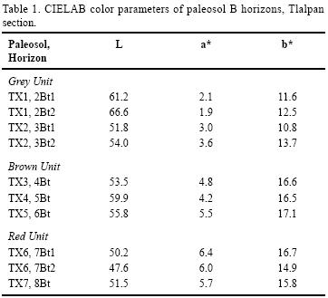
The color characteristics (Table 1) show clear differentiation within the Tlalpan sequence: the values of a* parameter (reflecting redness) increases from Grey to Brown Unit and reaches maximum in the Red Unit. The highest values of the b* (yellowness) parameter are registered in the Bt horizons of the Brown Unit. The Bt horizons of the Grey Unit have lowest values of both a* and b*, whereas L (lightness) is relatively high; this combination is typical for the mineral gleyic soils, poor in organic matter, where the color is determined mostly by the surfaces of the silicate particles, free of iron oxide coatings (Vodyanitskiy and Shishov, 2004).
Grain size distribution shows similar tendency of clay increase in the Bt horizons compared to tepetate in the three study units (Figure 3a). Clay content ranges from 41 to 57% in the paleosols, being higher in the Ah and Bt horizons than in tepetate. The highest values have been found in the Ah horizon of TX1, Bt of TX5 and Bt of TX7. In Mamut, clay content varies from 24.5 to 49.6%, similar values to those obtained in Tlalpan section, with high levels of accumulation in Bt horizons of TX1, TX1b and TX2 (Figure 3b).
The main differences in paleosol characteristics were found in the concentration of the Fed (Fe extracted by dithionite–citrate–bicarbonate solution) and Feo, Sio, Alo (Fe, Al, Si extracted by an oxalate solution). Fed values are relatively low in the Grey Unit (2 – 4.9 mg/g) while the highest ones are found in the Red Unit (9 to 12.1 mg/g), showing an elevated concentration of free (pedogenic) iron oxides. The Feo/Fed ratio, which provides an estimate of the proportion of poorly crystalline compounds within the total fine–grained pedogenic iron oxides, has very low values in the Red and the highest in the Grey Unit (Figure 3a and 3b). Sio and Alo exhibit similar values in the Brown and Red Units, however in the Grey Unit Sio content grows, reflecting the increase of the amorphous minerals. These values coincide with color characteristics.
Although Mamut paleosols demonstrate variation in the quantities of Fed, Feo, Alo, and Sio, they are within the same range of those obtained in the Grey Unit of Tlalpan section, supporting the correlation between both localities (Figure 3b).
X–ray diffraction patterns of clay fractions have clearly shown that the minerals of kaolinite group (1:1 type, identified by 7.2 Å peak) are dominant in all paleosols (Table 2). Traces of smectites (weak broad maximum at 14.5 Å, shifting to smaller angles in the specimen saturated with ethylene–glycol) have been found only in the uppermost paleosol of the Grey Unit (TX1); in all samples minor quantities of crystobalite and plagioclases are present, the latter showing a tendency to higher concentrations in BC and C horizons.
Within the 1:1 type, both dehydrated halloysite with poorer crystallinity (demonstrating high relative intensity of the non–basal maximum at 4.4 Å) and more crystallized kaolinite are present. We observed the following tendencies in the profile distribution of these components (Table 2):
1. Clay fractions of the Grey Unit paleosols are enriched with halloysite (this tendency is the clearest in the Mamut sequence), whereas kaolinite is more abundant in both Brown and Red Units.
2. Within each individual paleosol, kaolinite tends to accumulate in Bt horizons whereas indurated BC and C horizons (tepetate) contain more halloysite.
Instrumental dating of paleosols and parent materials
Radiocarbon dating of paleosol humus (Table 3) gave 14C ages of 38,160±5880 and >33,595 14C yr BP for TX2 paleosol in Tlalpan, whereas in Mamut section they are somewhat younger: 27,940±2,400 and 28,925±1,750 14C yr BP. In the overlying TX1b paleosol, the 14C ages of Bt horizons are 22,070±120 and 25,375±800 14C yr BP; in the AE horizon younger 14C ages 16,820±70 and 17,310±920 14C yr BP were obtained. In the Mamut section, radiocarbon ages from TX2 and TX1b paleosols are in clear agreement with their stratigraphic position; however, the 14C ages of TX1a paleosol (21,340±110 and 24,690±2,550 14C yr BP) are inverted; they are older than that of the underlying AE horizon of TX1b. Unexpectedly, pedogenic carbonates located within the Grey Unit produced a very young AMS date of 1,310±35 14C yr BP.
The K/Ar age from the lowest tephra (tepetate) sets the lower limit of the Tlaxcala sequence time scale at about 0.9 Ma (Table 4). The K/Ar ages of the underlying volcanic materials are older. In case of scoria from Tlaxco (1.35 and 1.39 Ma) the difference with the lowest tepetate is rather small (confidence intervals partly overlapping). On the contrary, the lava from Barranca Blanca is 1–1.5 Ma older than the lowest tepetate.
DISCUSSION
Paleosol chronology and correlation; record continuity.
Numerous pre–Hispanic artifacts indicate that the surface Holocene soil has a maximum age of about 3,500 yr BP – the time of the onset of cultural development in the Tlaxcala basin (Abascal et al. 1976; García–Cook 1976, Heine, 2003). The correlation between Grey Unit paleosols at Tlalpan and Mamut sections is supported by similarities of morphological, chemical and mineralogical characteristics of the TX2 paleosol as well as their stratigraphic relation to the underlying Brown Unit paleosols and tepetate. The radiocarbon dates of the TX2 paleosol differ in the two studied sections; however, taking into account the confidence interval, the difference could be just a few thousands years. Such variations of 14C ages are observed in some Holocene soils within a single soil profile (Alexandrovskiy and Chichagova, 1998). Considering that the radiocarbon dating of humus provides estimates of the minimum age of paleosols, we suggest that in Mamut, the TX2 paleosol was formed during MIS3, whereas TX1b formed during the first half of MIS2, including the Last Glacial Maximum. Regarding the inversion of 14C age in TX1a in relation to that of the underlying paleosol we suppose that the re–deposition of humus from older paleosols and its persistence in this very poorly developed soil is responsible for this phenomenon. We have detected numerous cases of 14C age inversions in Holocene profiles affected by intensive deposition of soil materials in the nearby Teotihuacan Valley (McClung de Tapia et al., 2005). A similar situation is proposed in the Mamut section, the site with evidence of higher sedimentation rates compared to Tlalpan. If this hypothesis is right, the development of TX1a corresponds to a short interval in the end of MIS2 whereas TX1 formation occurred in the early–middle Holocene. In Tlalpan section, the TX1 paleosol is most probably a pedocomplex that incorporates also TX1a and TX1b pedogenesis events in one soil body, due to restricted sedimentation in this site.
The AMS date of pedogenic carbonate: 1,310+35 yr shows that the timing of carbonate illuviation corresponds to the development of modern soil and not to the paleosols of the Grey Unit, although calcitic pedofeatures are located below the modern profile. Thus we consider this process within modern pedogenesis (see below) and associate it with the recent increase of aridity in the area, maybe synchronous with anthropogenic perturbation (Heine 2003).
The correlation of our pedostratigraphic scheme with the tephra stratigraphy developed for the Tlaxcala region by Heine and Schönhals (1973) and Aeppli and Schönhals (1975) yielded the following linkages: the tepetates of the Grey Unit (C horizons of TX1 and TX2) correspond to the tephra T2 (sub–units T2a and T2b respectively), whereas the upper tepetate of the Brown Unit (C–horizon of TX3) corresponds to T3. Major disagreement exists between the proposed chronologies: our age estimations are considerably older than 12,000 to 13,000 yr BP proposed for T2 (Miehlich 1978) and 20,000 – 40,000 yr BP for T3 (Werner et al., 1978). Regarding correlation with the regional pedostratigraphic scheme of Heine (1975, 1994a), we suppose that the TX1 paleosol is correlative to fBo3, TX1a – to fBo2 and TX1b – to fBo1. At the same time, the TX1a paleosol, its parent materials and the overlying sediments are supposed to be correlative with the Becerra Formation, developed in the Central Mexican Highlands during the terminal Pleistocene – early Holocene (Bryan, 1948), and identified in various localities of the Puebla–Tlaxcala Basin by Heine and Schönhals (1973).
New K/Ar dates allowed establishing a justified lower age limit for the Tlaxcala tephra–paleosol sequence. The age of 0.9 Ma (± 0.3) for the basal tepetate of the Red Unit establishes the time of sedimentation of paleosol parent material and the beginning of pedogenesis of the lowermost TX7 paleosol. Thus we assume that the Tlalpan sequence covers the whole middle and late Pleistocene and probably extends to the end of the early Pleistocene.
It should be noted that the dating of the Red Unit is consistent with the K/Ar dates from the volcanic rocks found below and fits well into the general context of the chronology and stratigraphy of the Tlaxcala block. In particular, the date 2.6 – 2.87 Ma for the andesitic lava from Barranca Blanca agrees well with the Pliocene–Pleistocene age of the underlying diatomites (Vilaclara et al., 1997). These authors report normal polarity for this lava, that according to our K/Ar dating we interpret as belonging to the Gauss Chron. Formation of the overlying tephra–paleosol sequence should have begun after some considerable delay following the termination of diatomite deposition and lava ejection. This delay is justified by 1–1.5 Ma lag between the K/Ar dates of andesite and Red Unit tephra as well as by geomorphological evidence. The orientation of tephra and paleosol strata conforms to the configuration of the major landforms of erosional relief of the Tlaxcala block. We conclude that the development of the studied sequence took place after the block uplift, which finished with the lacustrine environment and gave rise to the denudation geomorphic processes.
Decoding soil memory: pedogenetic and paleoenvironmental interpretation of paleosols
The set of pedogenetic processes in the modern soil and buried paleosols
Decoding of the paleopedological record implies first the pedogenetic interpretation of the soil and paleosol properties. The first step towards meeting this goal offers some difficulty, namely the comparison of buried paleosols with the surface Holocene soil. Strong and prolonged erosion, profound human disturbance, small thickness and "welding" with the underlying paleosol, among others, hamper a clear identification and classification of the modern soil profile. Thus, to compare modern soil with paleosol features we had to put together a puzzle of different observations and evidence.
The following phenomena were considered to be indicative of contemporary natural pedogenesis:
–Formation of a dark humus horizon, which in places fits the definition of mollic epipedon.
–Moderate clay content and occasional presence of thin illuvial clay coatings in B horizon (however never reaching the requirements for an Argic horizon).
–Presence of pedogenic carbonates. Although calcite concretions do occur in the TX1 paleosol below modern A and B horizons, the AMS age (1310 14C yr BP) indicates these features are the result of recent pedogenesis. It should be also taken into account that the TX1 groundmass is free of carbonates and that this paleosol has clay illuvial pedofeatures. It means that this paleosol had primarily been subjected to leaching and clay illuviation, whereas its recalcification occurred later.
These features point to the following set of pedogenetic processes: dark humus accumulation in the topsoil, weak weathering, leaching and clay illuviation in the middle part of the profile and carbonate precipitation below. In the WRB system (IUSS Working Group WRB, 2006) this profile corresponds to Molli–Calcic Cambisol. The evidences of deep long–term human impact (artifacts of different age, agrocutans, etc.) found in the study area are common for majority of surface soils of the Central Mexican Highlands.
Buried paleosols of the Tlalpan sequence differ significantly from the modern soil. None of them have evidence of carbonate neoformation or dark humus accumulation sufficient for the development of Mollic horizon. The main processes, clearly detectable in all these paleosols are:
–weathering of primary minerals, documented micromorphologically, together with the accumulation of the alteration products – pedogenic clay (mostly halloysite and kaolinite) and iron oxides;
–illuvial clay pedofeatures including: coatings and infillings, observed macromorphologically and in the thin sections;
–gleization (redoximorphic processes) also detected morphologically by the presence of ferruginous nodules, mottles, coatings.
Although the set of these pedogenetic processes was rather uniform throughout the Tlalpan sequence, their relative development differed greatly among the units.
Weathering as well as clay and iron oxide neoformation is most pronounced in the Red Unit, decreasing in the Brown and Grey Units. Micromorphological observations show that mineral alteration in the Red Unit paleosols extends over a thicker layer, affecting not only Bt, but also BC horizon (tepetate). The highest accumulation of pedogenic iron oxides is also registered in these paleosols. The neoformed iron oxides in the Red Unit have a high grade of crystallinity (lowest Feo/Fed ratio) and a larger proportion of haematite which gives the red color (highest a* values) to the soil mass. However, while the weathering grade of the Red Unit is highest of all these paleosols, it does not reach the advanced ferrallitic stage because there remain too many weatherable components and too little pedogenic iron oxide accumulated to qualify as a Ferralic horizon of IUSS Working Group WRB (2006). Alteration of primary minerals and accumulation of neoformed components in the Brown Unit is weaker compared to the Red Unit, however the differences are rather quantitative than qualitative, because in the Brown Unit the principal weathering products are also kaolinitic clay and crystalline iron oxides. The Grey Unit demonstrates quite different weathering status. The alteration products are less mature than in other units, with less crystallized halloysite dominant over kaolinite, elevated Sio content indicates higher amounts of amorphous minerals. In this unit Poetsch (2004) detected micromorphologically minor amounts of chemically precipitated opal.
Clay illuviation is best expressed in the Brown Unit, decreasing in the Grey and Red Units. However, we propose that in the Red Unit, the morphological results of illuviation are less abundant not because of the lower intensity of this process, but rather due to their partial destruction by pedoturbation. Besides fragmented clay pedofeatures (papules) this process is evidenced by excremental aggregates.
Gleization is strongest in the Grey Unit. In addition to numerous ferruginous pedofeatures, gleization is detected by color parameters and larger values of Feo/Fed that are known to increase in soils affected by redoximorphic processes. These results agree with the rock magnetic data of Ortega–Guerrero et al. (2004), who explain the minimum of magnetic susceptibility found in the Grey Unit by the destruction of magnetic minerals due to redoximorphic processes.
Morphological data from the Mamut sequence show clear variations of the set of pedogenetic processes within the Grey Unit. Gleization is pronounced in all Grey Unit paleosols with the strongest development in TX1a, which contrasts with its incipient weathering and clay illuviation. The latter processes are well expressed in TX1b and moderately expressed in TX1 and TX2. In the TX2 paleosol strong cracking, stress cutans and deformation of illuvial pedofeatures point to argillipedoturbation due to shrink–swell phenomena (Nettleton et al., 1969).
We propose that the differences in pedogenetic characteristics observed within the Tlaxcala paleosol sequence demonstrate the response of local pedogenesis to certain trends of global climate evolution as well as to regional scale natural and human–induced landscape processes.
Comparing surface soil and buried paleosols: the problem of the late Holocene aridity
Comparing the surface soil and all buried paleosols we observe contrasting qualitative differences in their pedogenesis that imply distinct bioclimatic conditions of soil formation. In the surface soil the set of the described pedogenetic processes fits well with the actual semihumid to semiarid seasonal climate.
In the buried paleosols, weathering and illuviation required a moist leaching soil environment whereas a prerequisite for redoximorphic processes is a period of water saturation. We conclude that during the whole middle and late Pleistocene and early Holocene soil development occurred under conditions much more moist than during the late Holocene. Within the Central Mexican Highlands, a similar trend was found in the volcanic paleosol sequence of the Teotihuacan Valley (Solleiro–Rebolledo et al. 2006) where late Pleistocene–early Holocene Luvisols are replaced by modern Kastanozems and Calcisols.
This pedological evidence could be correlated with the signals of pronounced late Holocene dry periods (or a set of droughts) in the interval 1400 to 800 14C yr BP (late Classic – early Postclassic period) and in the 17th to 19th centuries A.D. (coinciding with the Little Ice Age), which Metcalfe and Davies (2007) identified in a number of Central Mexican lacustrine records. Lozano–García et al. (2007) also detected a similar record in cores of Lago Verde in eastern Mesoamerica. The 14C date from the pedogenic carbonates at the top of the Tlaxcala sequence falls in the first interval.
Anthropogenic landscape transformation could also contribute to the development of "drier" pedogenesis in the late Holocene soils. The decline of trees and increase of herbs (Chenopodeacea and Amaranthacea) detected in the palynological spectra from the lake cores of Mexico (Lozano–García and Xelhuanzti–López, 1997) and Lerma basins (Lozano–García et al., 2005) together with high values of charcoal particles and presence of Zea mays pollen during the last ~3000 years are indicative of deforestation, frequent fires and land cultivation. In agreement with these data and with the archaeological reconstructions of population densities, Heine (2003) established human–induced acceleration of soil erosion and related downslope colluvial sedimentation in Puebla–Tlaxcala region. Large areas were eroded as early as 2000 years ago, whereas one of the major erosion maxima took place during the Texcalac and early Tlaxcala archaeological period, between 700 and 1300 yr AD, that coincide with the aridity interval proposed by Metcalfe and Davies (2007).
Strong soil erosion in the region should affect the soil moisture regime of the slopes and even watersheds through the following mechanisms: 1) sheet erosion producing loss of upper horizons, reduction of soil water holding capacity, increasing surface runoff; 2) linear erosion causing the development of gullies (barrancas) which should increase the drainage and lowers the groundwater level. Both mechanisms will decrease soil moisture and thus promote "drier" pedogenesis. The observed differences between the late Holocene soil and earlier paleosols in Tlaxcala sequence could be a result of a cumulative effect of natural climatic and human–induced environmental evolution trends.
Grey Unit paleosols: reconstructing the paleo–environmental dynamics during the Last Glaciation
A conspicuous feature of the Grey Unit when considered as a whole is its strong gleization despite the apparent well drained geomorphic position. Thus the reason for the redoximorphic processes is likely an excess of surface moisture, not groundwater saturation. Taking into account its low weathering status and immature neoformed components compared to the Brown and Red units, the most plausible reason for surface saturation is not an increase of precipitation but considerable decrease of evapotranspiration due to climate cooling. The domination of cool temperate forest ecosystems is a probable paleoecological scenario for the period of formation of the Grey Unit. This hypothesis is supported by the expression of the illuvial pedofeatures in the lower paleosols of the Grey Unit, namely the joint deposition of clay and dark humus in the Bt horizon, which is characteristic for Grey Forest soils (Greyic Luvisols in IUSS Working Group WRB [2006]), formed in the mixed forest and forest–steppe zones of Eurasia under mean annual temperatures 7 – 8 °C lower than that of Tlaxcala (Gerasimova et al., 1996; Miedema et al. 1999). Further evidence in favor of this scenario is provided by the palynological spectra from the Central Mexican Highlands which, despite the large scale fluctuations, demonstrate the domination of coniferous trees throughout MIS3–MIS2. Among them, besides Pinus and Abies, also Picea is recorded for different intervals within the period 50,000–10,000 yr BP (Lozano–García and Ortega–Guerrero, 1998; Caballero et al. 1999); the latter is a typical component of the coniferous boreal forests and is absent in the actual central Mexican flora.
The differences of pedogenesis within the Grey Unit allow tracing paleoclimatic changes during the upper late Pleistocene – early Holocene. The climate of the early–middle MIS3 (paleosol TX2) is believed to be drier, with the strongest seasonal variations of precipitation. These conditions could limit weathering and clay illuviation and promote vertic processes due to shrink–swell phenomena, which are linked to alternation of soil drying and wetting. In the Nevado de Toluca tephra–paleosol sequence, located some 100 km to the west of Tlaxcala at similar altitudes and corresponding to the same interval, well developed paleosols (PT2 and PT3) are present (Sedov et al., 2001). Although showing predominantly features of humid pedogenesis, these paleosols also have signs of wet/dry fluctuations recorded in the clay mineral assemblages and stable carbon isotope composition of humus (Sedov et al., 2003). Most lacustrine records demonstrate moderate to high lake levels and dominance of arboreal vegetation before 27,000 yr BP (Lozano–García and Ortega–Guerrero, 1998; Caballero et al. 1999) – again in good agreement with the paleopedological proxies. Regarding the regional glacial history, the TX2 paleosol formation period includes the M1 glacier advance (35,000 cal. yr BP) registered in various high volcanoes. Heine (1984, 1994b) proposed an extensive (~ 32–36 ka BP) period of geomorphic activity (accelerated erosion, deflation and eolian sedimentation) hampering soil formation at altitudes below 3000 m, associated with M1. Our observations apparently do not conform to this hypothesis. On the contrary, well developed Luvisol TX2 provides evidence of an extensive period of landsurface stability. However Poetsch (2004) reports in the BC horizon of TX2 a thin layer with micromorphological characteristics of sedimentation of "aquatic nature" at the base of the Grey Unit. According to the proposed chronostratigraphic scheme, these features could present a signal of enhancement of geomorphic processes corresponding to M1, perhaps rather short–term.
The TX1b paleosol displays major development of weathering and clay illuviation and absence of the vertic features during the Last Glacial Maximum (MIS2), which supports the concept of more uniform humidity than in the previous period. Other paleosols of the Central Mexican Highlands, formed during MIS2 at similar altitudes also demonstrate signs of humid forest pedogenesis. Paleosol fBo1 on the slopes of La Malinche (Heine, 1975), which yielded several 14C dates in the range 18,000 – 20,000 14C yr BP (Heine 1994a), is a thick Andosol that indicates moist climate and landsurface stability for several thousands years (Miehlich, 1991). In the Nevado de Toluca tephra–paleosol sequence, this period is documented by PT1 paleosol level, presented by Andosols and Cambisols (Sedov et al., 2001), which also show mostly signs of humid pedogenesis. In Teotihuacan (Solleiro–Rebolledo et al., 2006) in the upland positions, Luvisols were formed during this period, which are indicative of humid forest ecosystems.
These paleopedological proxies should be considered in connection with the existing controversy in the reconstruction of Last Glacial Maximum paleoclimate in Central Mexico. In a number of recent papers "cool and dry" conditions are attributed to this period based on the lacustrine and palynological records (e.g., Lozano–García and Ortega–Guerrero, 1998; Ortega–Guerrero et al., 2000). On the other hand Bradbury (1997b, 2000) proposed that this period was rather moist, with considerable winter rains and a predominantly Pacific source of atmospheric moisture. The data from the Tlaxcala sequence as well as the whole set of other paleopedological results (Sedov et al., 2001, 2003; Solleiro–Rebolledo et al., 2003, 2006) support the hypothesis of Bradbury.
Our explanation for the apparent discrepancies between paleopedological and lacustrine records for the Last Glacial Maximum consists of three main points:
1) patial variability of the paleoenvironments: Paleosols provide a highly site–specific record of local environmental conditions at elevated landforms (volcanic plateaus and higher slopes) with higher rates of humidity than in the valley bottoms.
2) Temporal variability of paleoenvironments: Soil memory has relatively low temporal resolution and often is not able to register short–term (below millennial scale) dry episodes.
3) Ambiguity of lacustrine records: some elements of the lacustrine records in central Mexico are not uniformly interpreted. For example, earlier studies of lake cores within the TMVB reported a lower ratio of arboreal to non–arboreal (AP/NAP) pollen as an important argument in favor of "drier" LGM (e.g., Ortega–Guerrero et al., 2000). However in a recent paper about the vegetation history of the Upper Lerma basin, although referring to LGM in central Mexico as being relatively dry, Lozano–García et al. (2005) state that "altitudinal fluctuation of the plant communities during the local glacial advances could explain the high percentages of grass pollen". They acknowledge that the increase of grass pollen in late Pleistocene strata could be due to the lowering of the tree line to about 3000 m.a.s.l. (currently close to 4000 m.a.s.l.) and the expansion of alpine meadows, thus presenting a temperature rather than humidity signal.
Red Unit paleosols – a record of the Mid Pleistocene Climatic Transition?
The Tlalpan sequence presents a proxy for the last ~ 900,000 years; the available sequence timescale is not sufficiently detailed to identify the local paleopedological responses to the periodic global climate fluctuations (i.e., glacial–interglacial cycles) within this period. However, it provides an opportunity (until now, unique) to trace the general tendency of regional environmental change throughout the middle and late Pleistocene and correlate it with the slow climatic transition registered within this period at the global scale.
Luvisols of the Red and Brown units demonstrate a set of soil forming processes typical for warm temperate to subtropical humid or subhumid forest ecosystems. However the higher weathering status of the Red Unit paleosols is not reproduced in the overlying soil units and must be reflecting some specific environmental conditions that favored mineral transformation and accumulation of secondary products.
The age of the tepetate at the base of the lowest TX7 paleosol allows us to link the beginning of Red Unit pedogenesis to the Mid Pleistocene Climatic Transition (MPT) – a pronounced global climate change, which is characterized by an increase of global ice volumes and the onset of the 100 ka cyclicity of glacial–interglacial cycles (Berger and Jansen, 1994) which were fully established around 650 ka (Mudelsee and Stattegger, 1997).
We hypothesize that the Red Unit paleosols reflect the environmental conditions of the MPT interim period in the Central Mexican Highlands. Their higher weathering status could be related not to much warmer and moister climate, but rather to the amplitude and intensity of climatic fluctuations. Low amplitude cyclicity of MPT provided a more stable environment and continuous uninterrupted pedogenesis over longer time intervals in the Red Unit. On the contrary the contrasting glacial/interglacial cycles with extensive cold phases would have promoted more dynamic environmental conditions that should break the continuity of pedogenetic processes during pedogenesis of the overlying younger paleosols. This change of the paleoclimate cyclicity is expected to especially effect weathering processes which are known to be one of the slowest pedogenetic processes, with a characteristic time of 105 – 106 yr (Targulian and Krasilnikov, 2007) – more than the duration of the 100 ka cycle. This implies that the advanced weathering stage needs environmental stability intervals longer than one glacial/interglacial cycle, which is why it was achieved during the MPT interim period and not reproduced within the post–MPT time.
ACKNOWLEDGEMENTS
This work was partially funded by several grants: DGAPA–PAPIIT IN104600 and IN110107; CONACyT 32337T, Conacyt–DFG MX00/014, and ICSU grant program 2003, project "Polygenetic models for Pleistocene paleosols". We thank E. Vallejo and A. González, for laboratory analyses; T. Pi for XRD data, J. Gama for field work assistance; M. Frechen and K. Heine for radiocarbon dating. We acknowledge the participation in the field work and fruitful discussions of all ICSU project participants. We are indebted to P. Jacobs for correcting English and for his useful review and comments on the manuscript. Thorough revision done by J.H. May and two anonymous reviewers helped a lot to improve the paper.
REFERENCES
Abascal, R., Dávila, P., Schmidt, P.J., De Dávila, D.Z., 1976, La arqueología del sur–oeste de Tlaxcala (primera parte): Puebla, México, Fundación Alemana para la Investigación Científica, Proyecto Puebla–Tlaxcala, Comunicaciones, 2, 74 pp. [ Links ]
Aeppli, H., 1973, Barroböden und Tepetate, Untersuchungen zur Bodenbildung in vulkanischen Aschen unter wechselfeuchtem, gemäβigtem Klima im zentralen Hochland von Mexiko: Giessen, Universität Giessen, Doctoral Thesis. [ Links ]
Aeppli, H., Schönhals, E., 1975, Los suelos en la cuenca de Puebla–Tlaxcala. Investigaciones acerca de su formación y clasificación: Wiesbaden, Franz Steiner Verlag, Das Mexiko–Projekt der Deutschen Forschungsgemeinschaft, 8, 153 p. [ Links ]
Alexandrovskiy, A.L., Chichagova, O.A., 1998, Radiocarbon age of Holocene paleosols of the East European forest–steppe zone: Catena, 34, 197–207. [ Links ]
Barron, V., Torrent, J., 1986, Use of the Kubelka–Munk theory to study the influence of iron oxides on soil color: Journal of Soil Science, 37, 499– 510. [ Links ]
Berger, W.H., Jansen, E., 1994, Mid–Pleistocene climate shift; the Nansen connection, in Johannessen, O.M., Muench, R.D., Overland, J.E. (eds.), The Polar Oceans and their Role in Shaping the Global Environment: The Nansen Centennial Volume: American Geophysical Union, Geophysical Monograph 85, 295–311. [ Links ]
Bradbury, J.P., 1997a, A diatom record of climate and hydrology for the past 200 ka from Owens Lake, California with comparison to other Great Basin lakes: Quaternary Science Reviews 16, 203–291. [ Links ]
Bradbury, J.P., 1997b, Sources of glacial moisture in Mesoamerica: Quaternary International, 43/44, 97–110. [ Links ]
Bradbury, J.P., 2000, Limnologic history of Lago de Pátzcuaro, Michoacán, Mexico for the past 48,000 years: impacts of climate and man: Palaeogeography, Palaeoclimatology, Palaeoecology, 163, 69–95. [ Links ]
Bryan, K., 1948, Los suelos complejos y fósiles de la altiplanicie de México, en relación a los cambios climáticos: Boletín de la Sociedad Geológica Mexicana, 13, 1–20. [ Links ]
Bullock, P., Fedoroff, N., Jongerius, A., Stoops, G., Tursina, T., Babel, U., 1985, Handbook for Soil Thin Section Description: Wolverhampton, Waine Research Publications, 152 p. [ Links ]
Bush, M.B., Colinvaux, P.A., 1990, A pollen record of a complete glacial cycle from lowland Panama: Journal of Vegetation Science 1, 105–118. [ Links ]
Caballero, M., Lozano–García, S., Ortega–Guerrero, B., Urrutia, J., Macías, J.L., 1999, Environmental characteristics of Lake Tecocomulco, northern basin of Mexico, for the last 50,000 years: Journal of Paleolimnology, 22, 399–411. [ Links ]
Caballero, M., Ortega–Guerrero, B., Valadez, F., Metcalfe, S., Macías, J.L., Sugiera, Y., 2002, Santa. Cruz Atizapan: a 22–ka lake level record and climatic implications in the Upper Lerma Basin, Central Mexico: Palaeogeography, Palaeoclimatology, Palaeoecology, 186, 217–235. [ Links ]
Cornwall, I.W., 1968, Outline of a stratigraphical "bridge" between the Mexico and Puebla basins, part I: Bulletin of the Institute of Archaeology, University of London, 7, 89–140. [ Links ]
Cornwall, I.W., 1969, Outline of a stratigraphical "bridge" between the Mexico and Puebla basins, part II: Bulletin of the Institute of Archaeology, University of London, 8, 1–54. [ Links ]
Dixon, J.B., Weed, S.B. (eds.), Minerals in soil environments: Madison, Wisconsin, USA, Soil Science Society of America, Book series, 2nd edition, 89 p. [ Links ]
García–Cook, A.G., 1976, El proyecto arqueológico Puebla–Tlaxcala: Puebla, México, Fundación Alemana para la Investigación Científica, Proyecto Puebla–Tlaxcala, Comunicaciones, 3. [ Links ]
García, E., 1988, Modificaciones al sistema de clasificación climática de Köppen: México, Universidad Nacional Autónoma de México, Instituto de Geografía, 217 p. [ Links ]
Gerasimova, M.I., Gubia, S.V., Shoba, S.A., 1996, Soils of Russia and Adjacent Countries: Geography and Micromorphology: The Netherlands, Van Gils, Wageningen Agricultural University, 204 pp. [ Links ]
González, C., Urrego, L.E., Martínez, J.I., 2006, Late Quaternary vegetation and climate change in the Panama Basin: Palynological evidence from marine cores ODP 677B and TR 163–38: Palaeogeography, Palaeoclimatology, Palaeoecology 234, 62–80. [ Links ]
Heine, K., 1974, Nuevas observaciones de la estratigrafía cuaternaria de la región del valle Puebla–Tlaxcala: Puebla, México, Fundación Alemana para la Investigación Científica, Comunicaciones 11, 1–4. [ Links ]
Heine, K., 1975, Studien zur jungquartären Glazialmorphologie mexikanischer Vulkane – mit einem Ausblick auf die Klimaentwicklung: Weisbaden, Franz Steiner Verlag, Das Mexiko–Projekt der Deutschen Forschungsgemeinschaft, 7, 178 pp. [ Links ]
Heine, K., 1984, The classical late Weichselian climatic fluctuations in Mexico, in Mörner, N.A., Karcén, W.D. (eds.), Climatic Changes on a Yearly to Millenial Basis. Geological, historical and instrumental records: Dordrecht, Reidel Publishing Company, 95–115. [ Links ]
Heine, K., 1988, Late Quaternary glacial chronology of the Mexican volcanoes: Die Geowissenschaften, 6, 197–205. [ Links ]
Heine, K., 1994a, The late–glacial moraine sequences in Mexico: is there evidence for the Younger Dryas event?: Palaeogeography, Palaeoclimatology, Palaeoecology, 112, 113–123. [ Links ]
Heine, K., 1994b, Present and past geocryogenic processes in Mexico: Permafrost and Periglacial Processes 5, 1–12. [ Links ]
Heine, K., 2003, Paleopedological evidence of human–induced environmental change in the Puebla–Tlaxcala area (Mexico) during the last 3,500 years: Revista Mexicana de Ciencias Geológicas, 20(3), 235–244. [ Links ]
Heine, K., Schönhals, E., 1973, Entstehung und Alter der "toba"–Sedimente in Mexiko: Eiszeitalter und Gegenwart, 23–24, 201–215. [ Links ]
Hessmann, R., 1992, Untersuchungen verhärteter Vulkanascheböden (Tepetate) in den Becken von Mexico und Tlaxcala (Mexico): Paris, Giessen, Bericht für die Kommission der Europäischen Gemeinschaft,. [ Links ]
Klink, H.J., Lauer, W., Ern, H., 1973, Erläuterungen zur vegetationskarte 1:2,000,000 des Puebla–Tlaxcala–Gebietes: Erkunde, 27, 225–229. [ Links ]
IUSS Working Group WRB, 2006, World Reference Base for Soil Resources 2006: Rome, Food and Agriculture Organization of the United Nations (FAO), World Soil Resources Reports No. 103, 2nd edition, 128 pp. [ Links ]
Leyden, B.W., Brenner, M., Hodell, D.A., Curtis, J.H., 1993, Late Pleistocene Climate in the Central American Lowlands, in Swart, P.K., Lohmann, K.C., McKenzie, J., Savin, S, Climate Change in Continental Isotopic Records: Washington, D.C., American Geophysical Union, Geophysical Monograph 78, 165–178. [ Links ]
Lozano–García, S., Ortega–Guerrero, B., 1998, Late Quaternary environmental changes of the central part of the Basin of Mexico; correlation between Texcoco and Chalco basins: Review of Palaeobotany and Palynology, 99, 77–93. [ Links ]
Lozano–García, S., Xelhuanzti, L.M.S., 1997, Some problems in the late Quaternary pollen records of central Mexico: Basin of Mexico and Zacapu: Quaternary International, 43–44, 117–123. [ Links ]
Lozano–García, S., Ortega–Guerrero, B., Sosa–Nájera, S., 2002, Mid– to Late–Wisconsin pollen record of San Felipe Basin, Baja California: Quaternary Research, 58, 84–92. [ Links ]
Lozano–García, S., Sosa–Nájera, S., Sugiera, Y., 2005, 23,000 yr of vegetation history of the Upper Lerma, a tropical high–altitude basin in Central México: Quaternary Research, 64, 70– 82. [ Links ]
Lozano–García, S., Caballero, M., Ortega–Guerrero, B., Rodríguez, A., Sosa, S., 2007, Tracing the effects of the Little Ice Age in the tropical lowlands of eastern Mesoamerica: Proceedings of the National Academy of Sciences of the United States of America (PNAS), 104(41), 16200–16203. [ Links ]
McClung de Tapia, E., Domínguez–Rubio, I., Gama–Castro, J., Solleiro–Rebolledo, E., Sedov, S., 2005, Radiocarbon dates from soil profiles in the Teotihuacan Valley, Mexico: indicators of geomorphological processes: Radiocarbon, 47(1), 159–175. [ Links ]
Metcalfe, S., Davies, S., 2007, Deciphering recent climate change in central Mexican lake records: Climatic Change, 83, 169–186. [ Links ]
Metcalfe, S., Say, A., Black, S., McCulloch, R., O'Hara, S., 2002, Wet Conditions during the Last Glaciation in the Chihuahuan Desert, Alta Babicora Basin, México: Quaternary Research, 57, 91–101. [ Links ]
Miedema, R., Koulechova, I.N., Gerasimova, M.I., 1999, Soil formation in Greyzems in Moscow district: micromorphology, chemistry, clay mineralogy and particle size distribution: Catena, 34(3–4), 315–347. [ Links ]
Miehlich, G., 1978, Eigenschaften und genese von Verhärtungslagen in Zentralmexiko ("tepetate"), in Miller, H. (ed.), Neuere Ergebnisse der geologischen Erforschung Latinamerikas: Münstersche Forschungen zur Geologie und Paläontologie, 44–45, 27–41. [ Links ]
Miehlich, G., 1991, Chronosequences of volcanic ash soils: Hamburg, Hamburger Bodenkundliche Arbeiten, 15, 207 pp. [ Links ]
Mooser, F., 1975, Historia geológica de la Cuenca de México: Memorias de las obras del sistema de drenaje profundo del Distrito Federal: México D.F., Departamento del Distrito Federal, Tomo I, 7–38. [ Links ]
Mudelsee, M., Stattegger, K., 1997, Exploring the structure of the mid–Pleistocene revolution with the advanced methods of time–series análisis: Geologische Rundschau, 86, 499–511. [ Links ]
Munsell Soil Color Charts, 1975, Macbeth, Division of Kollmorgen Corporation, Baltimore, Maryland. [ Links ]
Nettleton, W.D., Flach, K.W., Brasher, B.R., 1969, Argillic horizons without clay skins: Soil Science Society of America Procedures, 33, 121–125. [ Links ]
Ortega–Guerrero, B., Thompson, R., Urrutia–Fucugauchi, J., 2000, Magnetic properties of lake sediments from Lake Chalco, central Mexico, and their palaeoenvironmental implications: Journal of Quaternary Science, 15, 127–140. [ Links ]
Ortega–Guerrero, B., Sedov, S., Solleiro–Rebolledo, E., Soler, A., 2004, Magnetic mineralogy in the Barranca Tlalpan exposure paleosols, Tlaxcala, Mexico: Revista Mexicana de Ciencias Geológicas, 21(1), 120–132. [ Links ]
Peterson, L.C., Haug, G.H., Hughen, K.A., Röhl, U., 2000, Rapid changes in the hydrologic cycle of the tropical Atlantic during the last glacial: Science, 290(4598), 1947–1951. [ Links ]
Poetsch, T., 2004, Forms and dynamics of silica gel in a tuff–dominated soil complex: Results of micromorphological studies in the Central Highlands of Mexico: Revista Mexicana de Ciencias Geológicas, 21(1), 195–201. [ Links ]
Retallack, G.J., 1990, Soils of the past: an introduction to paleopedology: London, Wiley–Blackwell, second edition, 404 pp. [ Links ]
Rico, R., Vilaclara, G., Miranda, J., Cañetas, J., 1997, Origin of laminations in Tlaxcala paleolake, Mexico: Internationale Vereinigung für theoretische und angewandte Limnologie, Verhandlungen, 26(2), 838–841. [ Links ]
Rivas, J., Ortega, B., Sedov, S., Solleiro–Rebolledo, E., Sycheva, S., 2006, Rock magnetism and pedogenetic processes in Luvisol profiles: Examples from Central Russia and Central Mexico: Quaternary International, 156/157, 212–223. [ Links ]
Sedov, S., Solleiro–Rebolledo, E., Gama–Castro, J.E., Vallejo–Gómez, E., González–Velázquez, A., 2001, Buried paleosols of Nevado de Toluca: an alterative record of Late Quaternary environmental change in Central Mexico: Journal of Quaternary Science, 16(4), 375–389. [ Links ]
Sedov, S., Solleiro–Rebolledo, E., Morales–Puente, P., Arias–Herrería, A., Vallejo–Gómez E., Jasso–Castañeda, C., 2003, Mineral and organic components of the buried paleosols of the Nevado de Toluca/central Mexico as indicators of paleoenvironments and soil evolution: Quaternary International, 106–107, 169–184. [ Links ]
Solé, J., Enrique, P., 2001, X–ray fluorescence analysis for the determination of potassium in small quantities of silicate minerals for K–Ar dating: Analytica Chimica Acta, 440, 199–205. [ Links ]
Solleiro–Rebolledo, E., Sedov, S., Gama–Castro, J.E., Flores–Román, D., Escamilla–Sarabia, G., 2003, Paleosol–sedimentary sequences of the Glacis de Buenavista, central Mexico: interaction of Late Quaternary pedogenesis and volcanic sedimentation: Quaternary International, 106–107, 185–201. [ Links ]
Solleiro–Rebolledo, E., Sedov, S., McClung, E., Cabadas, H., Gama–Castro, J., Vallejo–Gómez, E., 2006, Spatial variability of environment change in the Teotihuacan valley during late Quaternary: paleopedological inferences: Quaternary International, 156–157, 13–31. [ Links ]
Steiger, R.H., Jäger, E., 1977, Subcomission on geochronology: Convention on the use of decay constants in geo– and cosmochronology: Earth and Planetary Science Letters, 36, 359–362. [ Links ]
Straka, H., Ohngemach, D., 1989, Late Quaternary vegetation history of the Mexican Highland: Plant Systematics and Evolution, 162, 115–132. [ Links ]
Targulian, V.O., Goryachkin, S.V., 2004, Soil memory: Types of record, carriers, hierarchy and diversity: Revista Mexicana de Ciencias Geológicas, 21(1), 1–8. [ Links ]
Targulian, V.O., Krasilnikov, P.V., 2007, Soil system and pedogenic processes: self–organization, time scales, and environmental significance: Catena 71(3), 373–381. [ Links ]
Thompson, R.S., Whitlock, C., Bartlein, P.J., Harrison, S.P., Spaulding, W.G., 1993, Climatic changes in the western United States since 18,000 yr BP, in Wright, H.E. Jr., Kutzbach, J.E., Webb, T. III, Ruddiman, W.F., Street–Perrott, F.A., Bartlein, P.J. (eds.), Global Climates Since the Last Glacial Maximum: Minneapolis, University of Minnesota Press, 468–513. [ Links ]
United States Department of Agriculture (USDA), 1996, Soil Survey Laboratory Methods Manual: U.S. Department of Agriculture, National Resources Conservation Services, National Soil Survey Centre, Soil Survey Investigations Report No. 42. [ Links ]
Vázquez–Selem, L., 1997, Late Quaternary glaciations of Téyotl volcano, Central Mexico: Quaternary International, 43–44, 67–73. [ Links ]
Vázquez–Selem, L., Heine, K., 2004, Late Quaternary glaciation of Mexico, in Ehlers, J., Gibbard, P.L. (eds.), Quaternary Glaciations– Extent and Chronology, Part III. South America, Asia, Africa, Australasia, Antarctica: Amsterdam, Elsevier, Developments in Quaternary Science, 2, 233–242. [ Links ]
Vilaclara, G., Rico, R., Miranda, J., 1997, Effects of perturbations on diatom assemblages in Tlaxcala paleolake, Mexico: Internationale Vereinigung für theoretische und angewandte Limnologie, Verhandlungen, 26(2), 846–851. [ Links ]
Vodyanitskiy, Yu.N., Shishov, L.L., 2004, Izuchenie nekotorih pochvennih processov po cvetu pochvi (Some soil processes and their study by using the soil colour): Moscow, Russia, Dokuchaev Soil Science Institute. [ Links ]
Watts, W.A., Bradbury, J.P., 1982, Paleoecological studies at Lake Patzcuaro on the West–Central Mexican Plateau and at Chalco in the Basin of Mexico: Quaternary Research, 17, 56–70. [ Links ]
Werner, G., Aeppli, H., Miehlich, G., Schönhals, E.. 1978, Los suelos de la cuenca alta de Puebla–Tlaxcala y sus alrededores. Comentarios a un mapa de suelos: Puebla, México, Fundación Alemana para la Investigación Científica, Proyecto Puebla–Tlaxcala, Comunicaciones, 6, 95 pp. [ Links ]
White, S.E., 1986, Quaternary glacial stratigraphy and chronology of Mexico: Quaternary Science Reviews, 5, 201–205. [ Links ]
White, S.E., Valastro, S.J., 1984, Pleistocene glaciation of Volcano Ajusco, Central Mexico, and comparison with standard Mexican glacial sequence: Quaternary Research, 21, 21–35. [ Links ]

